MaddenJulian Oscillation Recent Evolution Current Status and Predictions
- Slides: 21

Madden-Julian Oscillation: Recent Evolution, Current Status and Predictions Update prepared by: Climate Prediction Center / NCEP 11 December 2017

Outline Overview Recent Evolution and Current Conditions MJO Index Information MJO Index Forecasts MJO Composites

Overview The CPC velocity potential-based and RMM-based MJO indices indicate a MJO signal with the enhanced phase approaching the Western Hemisphere. This envelope is forecast to continue eastward over the next two weeks, although the propagation may be masked somewhat in the RMM index by a competing easterly signal in association with a Kelvin wave approaching the Indian Ocean at present. Equatorial Rossby wave activity in the Central Pacific may further muddy this perspective. The MJO is favored to continue propagating eastward over the West Pacific (Phase 7) for the majority of Week-1, before progressing into Phase-8 during Week-2. An active MJO over the West Pacific suggests a colder solution from the Northern Plains through the East in approximately two weeks. As the MJO envelope shifts into the Western Hemisphere, lagged impacts over the U. S. become less robust. Additional potential impacts across the global tropics and a discussion for the U. S. are available at: http: //www. cpc. ncep. noaa. gov/products/precip/CWlink/ghazards/index. php

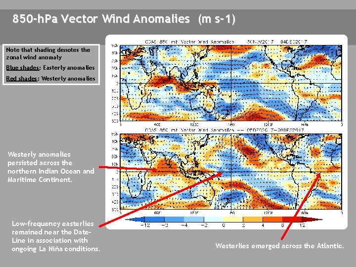
850 -h. Pa Vector Wind Anomalies (m s-1) Note that shading denotes the zonal wind anomaly Blue shades: Easterly anomalies Red shades: Westerly anomalies persisted across the northern Indian Ocean and Maritime Continent. Low-frequency easterlies remained near the Date. Line in association with ongoing La Niña conditions. Westerlies emerged across the Atlantic.

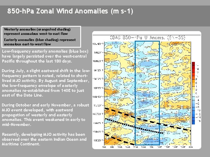
850 -h. Pa Zonal Wind Anomalies (m s-1) Westerly anomalies (orange/red shading) represent anomalous west-to-east flow Easterly anomalies (blue shading) represent anomalous east-to-west flow Low-frequency easterly anomalies (blue box) have largely persisted over the west-central Pacific throughout the last 180 days. During July, a slight eastward shift in the lowfrequency pattern is noted, related to shortlived MJO activity. By August and September, the low-frequency envelope of easterly anomalies re-established from 140 E to just east of the Date Line. During October and early November, a robust MJO event developed, with eastward propagation of westerly and easterly anomalies. This event weakened in early to mid-November. Recently, developing MJO activity has been observed over the eastern Indian Ocean and Maritime Continent.

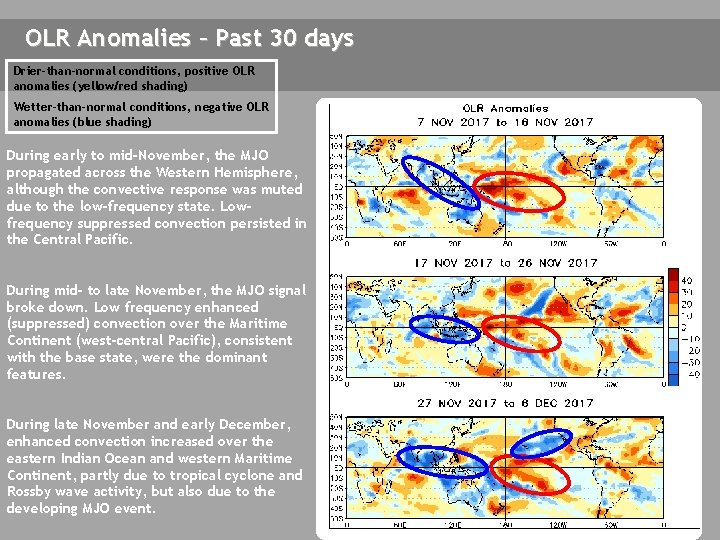
OLR Anomalies – Past 30 days Drier-than-normal conditions, positive OLR anomalies (yellow/red shading) Wetter-than-normal conditions, negative OLR anomalies (blue shading) During early to mid-November, the MJO propagated across the Western Hemisphere, although the convective response was muted due to the low-frequency state. Lowfrequency suppressed convection persisted in the Central Pacific. During mid- to late November, the MJO signal broke down. Low frequency enhanced (suppressed) convection over the Maritime Continent (west-central Pacific), consistent with the base state, were the dominant features. During late November and early December, enhanced convection increased over the eastern Indian Ocean and western Maritime Continent, partly due to tropical cyclone and Rossby wave activity, but also due to the developing MJO event.

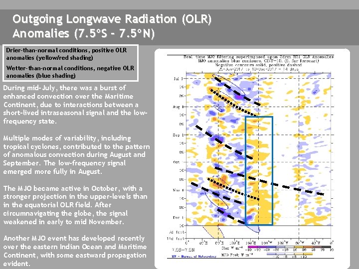
Outgoing Longwave Radiation (OLR) Anomalies (7. 5ºS - 7. 5ºN) Drier-than-normal conditions, positive OLR anomalies (yellow/red shading) Wetter-than-normal conditions, negative OLR anomalies (blue shading) During mid-July, there was a burst of enhanced convection over the Maritime Continent, due to interactions between a short-lived intraseasonal signal and the lowfrequency state. Multiple modes of variability, including tropical cyclones, contributed to the pattern of anomalous convection during August and September. The low-frequency signal emerged more fully in August. The MJO became active in October, with a stronger projection in the upper-levels than in the equatorial OLR field. After circumnavigating the globe, the signal weakened in early to mid November. Another MJO event has developed recently over the eastern Indian Ocean and Maritime Continent, with some eastward propagation evident.

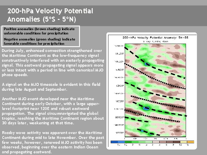
200 -h. Pa Velocity Potential Anomalies (5ºS - 5ºN) Positive anomalies (brown shading) indicate unfavorable conditions for precipitation Negative anomalies (green shading) indicate favorable conditions for precipitation During July, enhanced convection strengthened over the Maritime Continent as the low-frequency signal constructively interfered with an easterly propagating signal. This eastward propagating signal appears more or less intact with a period in line with canonical MJO phase speeds. A signal on the MJO timescale is evident in this field during late August and September. Another MJO event developed near the Maritime Continent during early October, with a large upperlevel footprint near 120 E and robust eastward propagation. The signal circumnavigated the global tropics, reaching the Maritime Continent region about 30 days later, weakening at that time. Rossby wave activity was apparent over the Maritime Continent during mid to late November. Over the past few weeks, however, renewed MJO activity has been observed, beginning over the eastern Indian Ocean and propagating eastward.

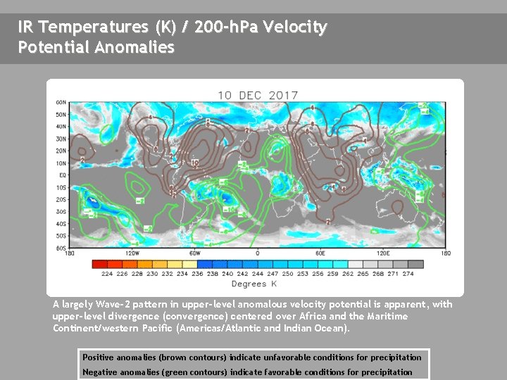
IR Temperatures (K) / 200 -h. Pa Velocity Potential Anomalies THIS SLIDE NOT UPDATED A largely Wave-2 pattern in upper-level anomalous velocity potential is apparent, with upper-level divergence (convergence) centered over Africa and the Maritime Continent/western Pacific (Americas/Atlantic and Indian Ocean). Positive anomalies (brown contours) indicate unfavorable conditions for precipitation Negative anomalies (green contours) indicate favorable conditions for precipitation

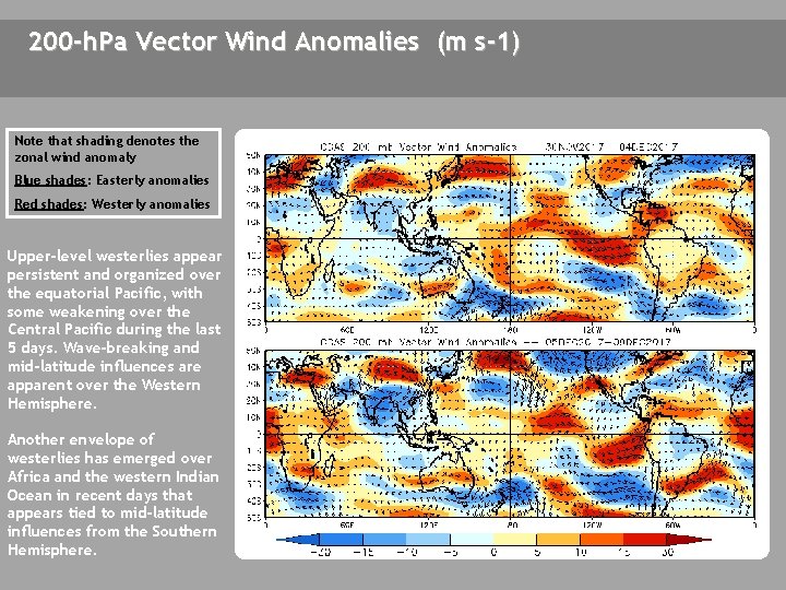
200 -h. Pa Vector Wind Anomalies (m s-1) Note that shading denotes the zonal wind anomaly Blue shades: Easterly anomalies Red shades: Westerly anomalies Upper-level westerlies appear persistent and organized over the equatorial Pacific, with some weakening over the Central Pacific during the last 5 days. Wave-breaking and mid-latitude influences are apparent over the Western Hemisphere. Another envelope of westerlies has emerged over Africa and the western Indian Ocean in recent days that appears tied to mid-latitude influences from the Southern Hemisphere. D C

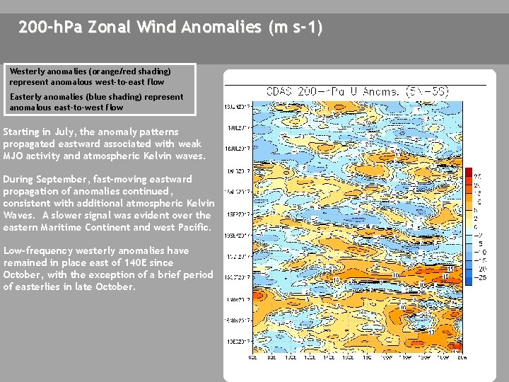
200 -h. Pa Zonal Wind Anomalies (m s-1) Westerly anomalies (orange/red shading) represent anomalous west-to-east flow Easterly anomalies (blue shading) represent anomalous east-to-west flow Starting in July, the anomaly patterns propagated eastward associated with weak MJO activity and atmospheric Kelvin waves. During September, fast-moving eastward propagation of anomalies continued, consistent with additional atmospheric Kelvin Waves. A slower signal was evident over the eastern Maritime Continent and west Pacific. Low-frequency westerly anomalies have remained in place east of 140 E since October, with the exception of a brief period of easterlies in late October.

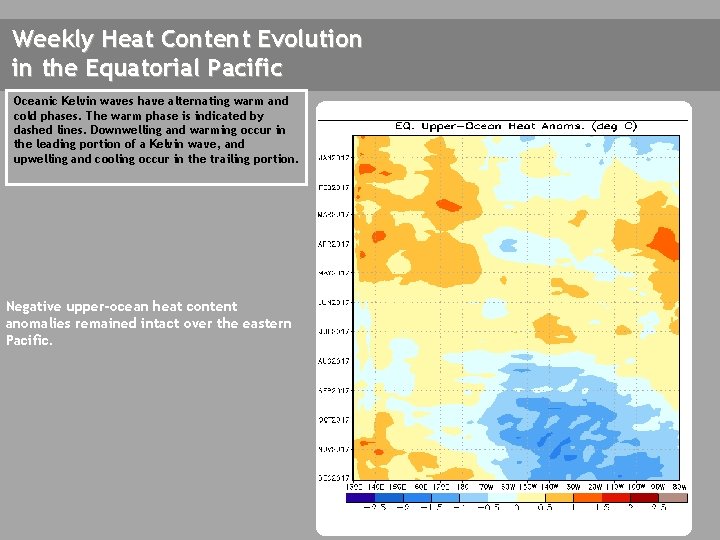
Weekly Heat Content Evolution in the Equatorial Pacific Oceanic Kelvin waves have alternating warm and cold phases. The warm phase is indicated by dashed lines. Downwelling and warming occur in the leading portion of a Kelvin wave, and upwelling and cooling occur in the trailing portion. Negative upper-ocean heat content anomalies remained intact over the eastern Pacific.

MJO Index -- Information The MJO index illustrated on the next several slides is the CPC version of the Wheeler and Hendon index (2004, hereafter WH 2004). Wheeler M. and H. Hendon, 2004: An All-Season Real-Time Multivariate MJO Index: Development of an Index for Monitoring and Prediction, Monthly Weather Review, 132, 1917 -1932. The methodology is very similar to that described in WH 2004 but does not include the linear removal of ENSO variability associated with a sea surface temperature index. The methodology is consistent with that outlined by the U. S. CLIVAR MJO Working Group. Gottschalck et al. 2010: A Framework for Assessing Operational Madden-Julian Oscillation Forecasts: A CLIVAR MJO Working Group Project, Bull. Amer. Met. Soc. , 91, 1247 -1258. The index is based on a combined Empirical Orthogonal Function (EOF) analysis using fields of near-equatorially-averaged 850 -h. Pa and 200 -h. Pa zonal wind and outgoing longwave radiation (OLR).

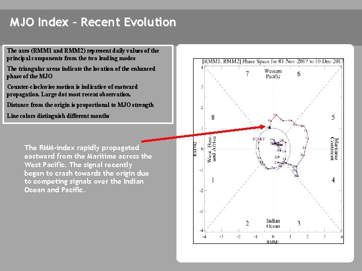
MJO Index – Recent Evolution The axes (RMM 1 and RMM 2) represent daily values of the principal components from the two leading modes The triangular areas indicate the location of the enhanced phase of the MJO Counter-clockwise motion is indicative of eastward propagation. Large dot most recent observation. Distance from the origin is proportional to MJO strength Line colors distinguish different months The RMM-index rapidly propagated eastward from the Maritime across the West Pacific. The signal recently began to crash towards the origin due to competing signals over the Indian Ocean and Pacific.

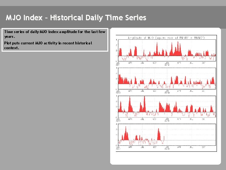
MJO Index – Historical Daily Time Series Time series of daily MJO index amplitude for the last few years. Plot puts current MJO activity in recent historical context.

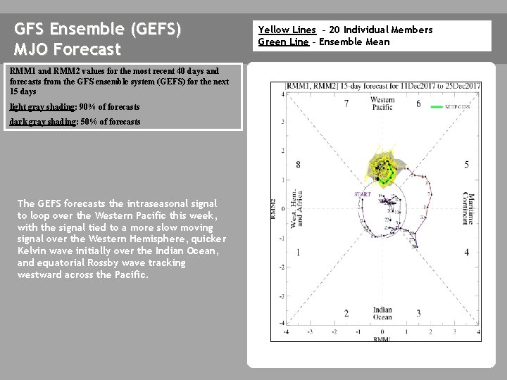
GFS Ensemble (GEFS) MJO Forecast RMM 1 and RMM 2 values for the most recent 40 days and forecasts from the GFS ensemble system (GEFS) for the next 15 days light gray shading: 90% of forecasts dark gray shading: 50% of forecasts The GEFS forecasts the intraseasonal signal to loop over the Western Pacific this week, with the signal tied to a more slow moving signal over the Western Hemisphere, quicker Kelvin wave initially over the Indian Ocean, and equatorial Rossby wave tracking westward across the Pacific. Yellow Lines – 20 Individual Members Green Line – Ensemble Mean

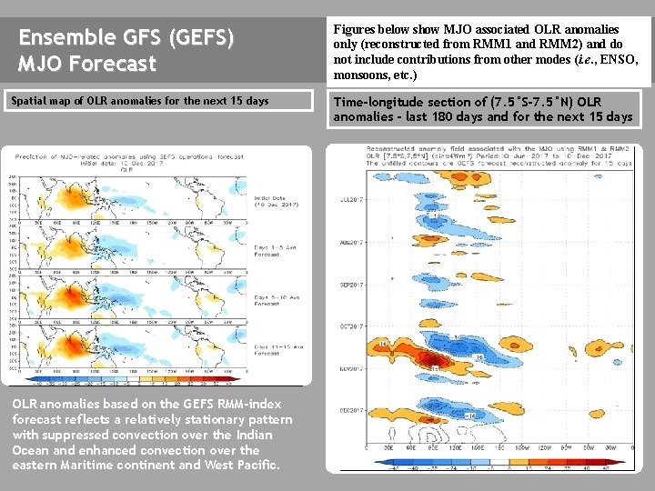
Ensemble GFS (GEFS) MJO Forecast Spatial map of OLR anomalies for the next 15 days The GEFS plot of MJO related OLR anomalies is unavailable at this time. OLR anomalies based on the GEFS RMM-index forecast reflects a relatively stationary pattern with suppressed convection over the Indian Ocean and enhanced convection over the eastern Maritime continent and West Pacific. Figures below show MJO associated OLR anomalies only (reconstructed from RMM 1 and RMM 2) and do not include contributions from other modes (i. e. , ENSO, monsoons, etc. ) Time-longitude section of (7. 5°S-7. 5°N) OLR anomalies - last 180 days and for the next 15 days The GEFS plot of MJO related OLR anomalies is unavailable at this time.

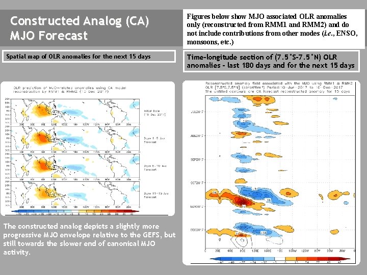
Constructed Analog (CA) MJO Forecast Figures below show MJO associated OLR anomalies only (reconstructed from RMM 1 and RMM 2) and do not include contributions from other modes (i. e. , ENSO, monsoons, etc. ) Spatial map of OLR anomalies for the next 15 days Time-longitude section of (7. 5°S-7. 5°N) OLR anomalies - last 180 days and for the next 15 days The GEFS plot of MJO related OLR anomalies is unavailable at this time. The constructed analog depicts a slightly more progressive MJO envelope relative to the GEFS, but still towards the slower end of canonical MJO activity.

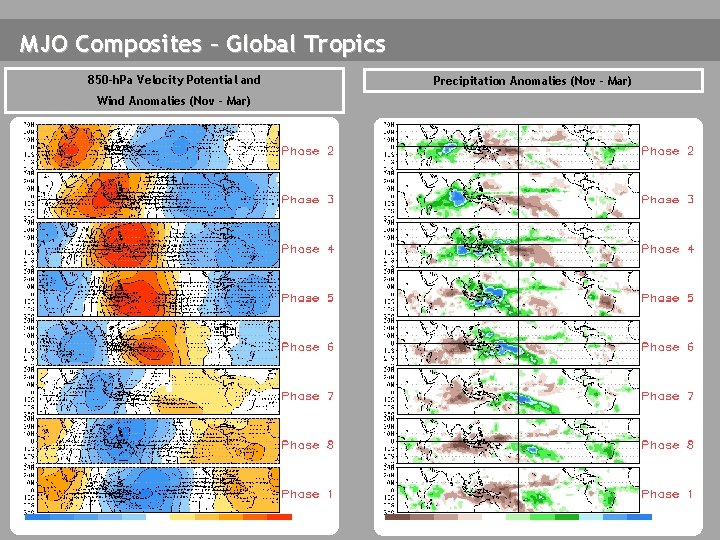
MJO Composites – Global Tropics 850 -h. Pa Velocity Potential and Wind Anomalies (Nov - Mar) Precipitation Anomalies (Nov - Mar)

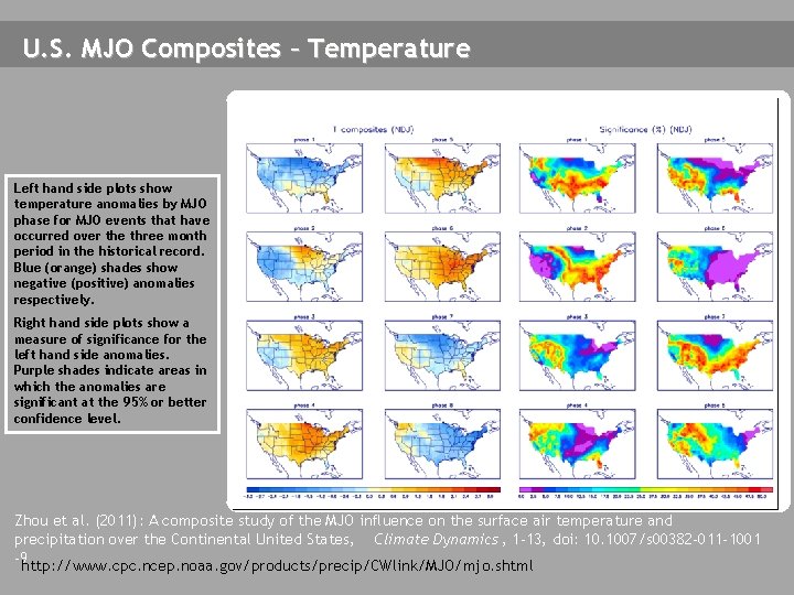
U. S. MJO Composites – Temperature Left hand side plots show temperature anomalies by MJO phase for MJO events that have occurred over the three month period in the historical record. Blue (orange) shades show negative (positive) anomalies respectively. Right hand side plots show a measure of significance for the left hand side anomalies. Purple shades indicate areas in which the anomalies are significant at the 95% or better confidence level. Zhou et al. (2011): A composite study of the MJO influence on the surface air temperature and precipitation over the Continental United States, Climate Dynamics , 1 -13, doi: 10. 1007/s 00382 -011 -1001 -9 http: //www. cpc. ncep. noaa. gov/products/precip/CWlink/MJO/mjo. shtml

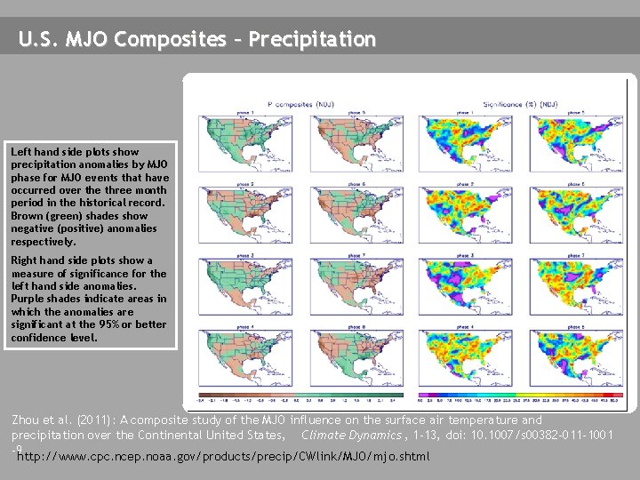
U. S. MJO Composites – Precipitation Left hand side plots show precipitation anomalies by MJO phase for MJO events that have occurred over the three month period in the historical record. Brown (green) shades show negative (positive) anomalies respectively. Right hand side plots show a measure of significance for the left hand side anomalies. Purple shades indicate areas in which the anomalies are significant at the 95% or better confidence level. Zhou et al. (2011): A composite study of the MJO influence on the surface air temperature and precipitation over the Continental United States, Climate Dynamics , 1 -13, doi: 10. 1007/s 00382 -011 -1001 -9 http: //www. cpc. ncep. noaa. gov/products/precip/CWlink/MJO/mjo. shtml