MaddenJulian Oscillation Recent Evolution Current Status and Predictions
- Slides: 21

Madden-Julian Oscillation: Recent Evolution, Current Status and Predictions Update prepared by Climate Prediction Center / NCEP May 2, 2011

Outline • Overview • Recent Evolution and Current Conditions • MJO Index Information • MJO Index Forecasts • MJO Composites

Overview • The MJO signal remained weak, despite a small amount of strengthening over the past week. Some eastward propagation was observed. • The dynamical model MJO index forecasts indicate an increase in strength during Week-1 with continued eastward propagation during the entire two week period. • The current signal is propagating faster than typical MJO activity, but model forecasts indicate a slowing signal during Week-2. • Based on the latest observations and majority of model forecasts, the MJO and other modes of tropical variability are expected to contribute to enhanced rainfall across the Maritime Continent and northern South America. The suppressed phase of the MJO should contribute to drying across the Indian Ocean during Week-2. Additional potential impacts across the global tropics are available at: http: //www. cpc. ncep. noaa. gov/products/precip/CWlink/ghazards/index. php

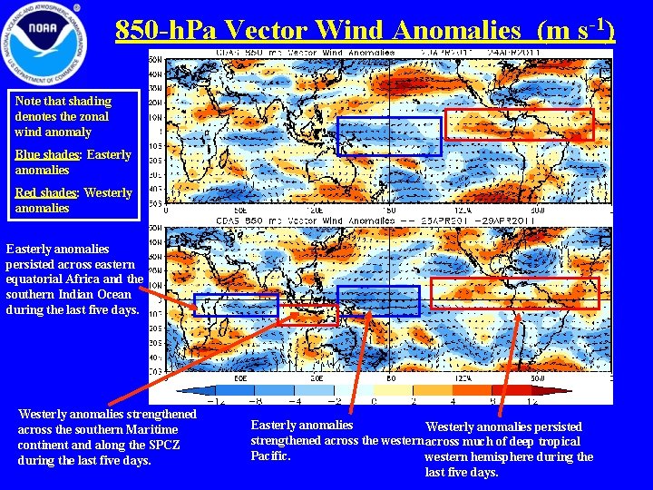
850 -h. Pa Vector Wind Anomalies (m s-1) Note that shading denotes the zonal wind anomaly Blue shades: Easterly anomalies Red shades: Westerly anomalies Easterly anomalies persisted across eastern equatorial Africa and the southern Indian Ocean during the last five days. Westerly anomalies strengthened across the southern Maritime continent and along the SPCZ during the last five days. Easterly anomalies Westerly anomalies persisted strengthened across the western across much of deep tropical Pacific. western hemisphere during the last five days.

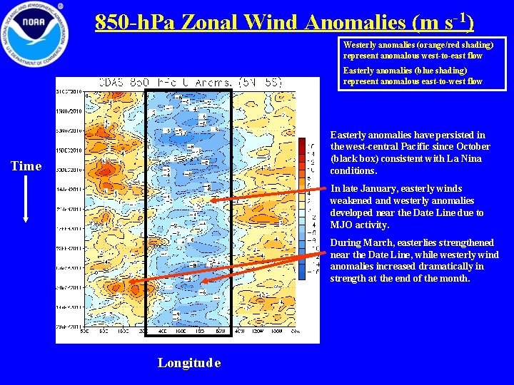
850 -h. Pa Zonal Wind Anomalies (m s-1) Westerly anomalies (orange/red shading) represent anomalous west-to-east flow Easterly anomalies (blue shading) represent anomalous east-to-west flow Easterly anomalies have persisted in the west-central Pacific since October (black box) consistent with La Nina conditions. Time In late January, easterly winds weakened and westerly anomalies developed near the Date Line due to MJO activity. During March, easterlies strengthened near the Date Line, while westerly wind anomalies increased dramatically in strength at the end of the month. Longitude

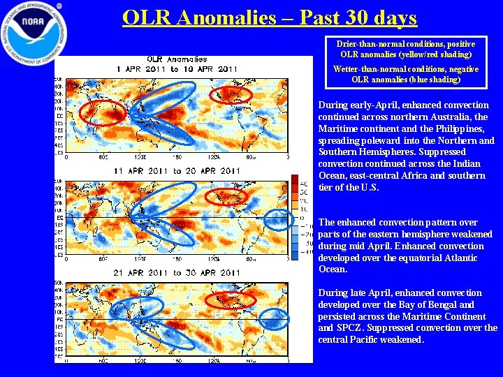
OLR Anomalies – Past 30 days Drier-than-normal conditions, positive OLR anomalies (yellow/red shading) Wetter-than-normal conditions, negative OLR anomalies (blue shading) During early-April, enhanced convection continued across northern Australia, the Maritime continent and the Philippines, spreading poleward into the Northern and Southern Hemispheres. Suppressed convection continued across the Indian Ocean, east-central Africa and southern tier of the U. S. The enhanced convection pattern over parts of the eastern hemisphere weakened during mid April. Enhanced convection developed over the equatorial Atlantic Ocean. During late April, enhanced convection developed over the Bay of Bengal and persisted across the Maritime Continent and SPCZ. Suppressed convection over the central Pacific weakened.

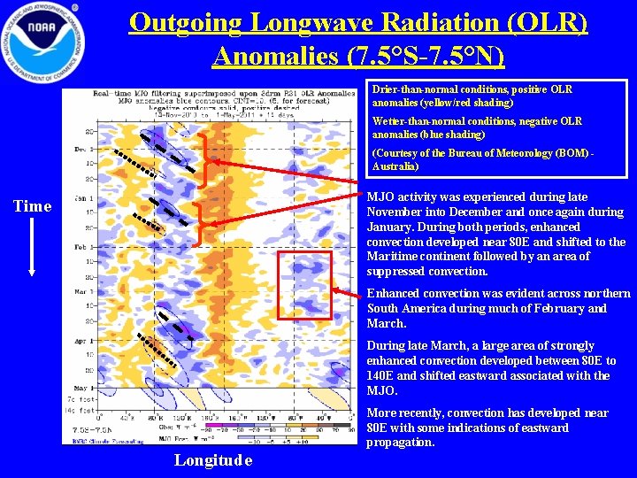
Outgoing Longwave Radiation (OLR) Anomalies (7. 5°S-7. 5°N) Drier-than-normal conditions, positive OLR anomalies (yellow/red shading) Wetter-than-normal conditions, negative OLR anomalies (blue shading) (Courtesy of the Bureau of Meteorology (BOM) Australia) MJO activity was experienced during late November into December and once again during January. During both periods, enhanced convection developed near 80 E and shifted to the Maritime continent followed by an area of suppressed convection. Time Enhanced convection was evident across northern South America during much of February and March. During late March, a large area of strongly enhanced convection developed between 80 E to 140 E and shifted eastward associated with the MJO. More recently, convection has developed near 80 E with some indications of eastward propagation. Longitude

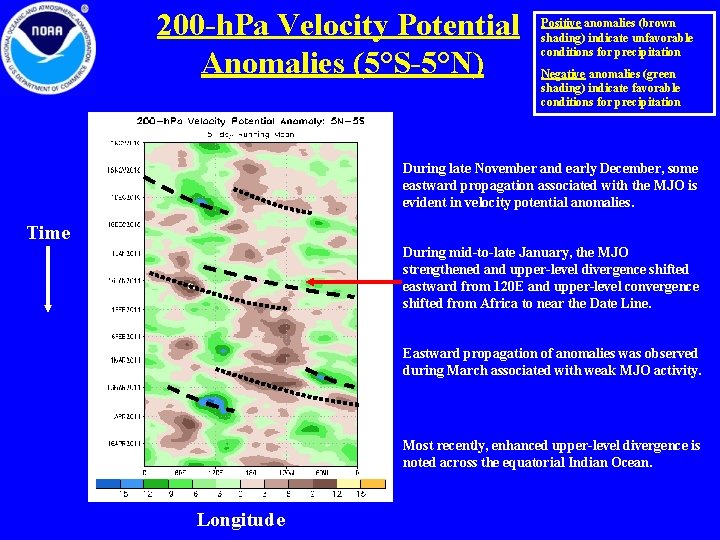
200 -h. Pa Velocity Potential Anomalies (5°S-5°N) Positive anomalies (brown shading) indicate unfavorable conditions for precipitation Negative anomalies (green shading) indicate favorable conditions for precipitation During late November and early December, some eastward propagation associated with the MJO is evident in velocity potential anomalies. Time During mid-to-late January, the MJO strengthened and upper-level divergence shifted eastward from 120 E and upper-level convergence shifted from Africa to near the Date Line. Eastward propagation of anomalies was observed during March associated with weak MJO activity. Most recently, enhanced upper-level divergence is noted across the equatorial Indian Ocean. Longitude

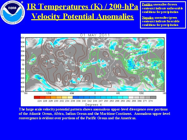
IR Temperatures (K) / 200 -h. Pa Velocity Potential Anomalies Positive anomalies (brown contours) indicate unfavorable conditions for precipitation Negative anomalies (green contours) indicate favorable conditions for precipitation The large scale velocity potential pattern shows anomalous upper-level divergence over portions of the Atlantic Ocean, Africa, Indian Ocean and the Maritime Continent. Anomalous upper-level convergence is evident over portions of the Pacific Ocean and the Americas.

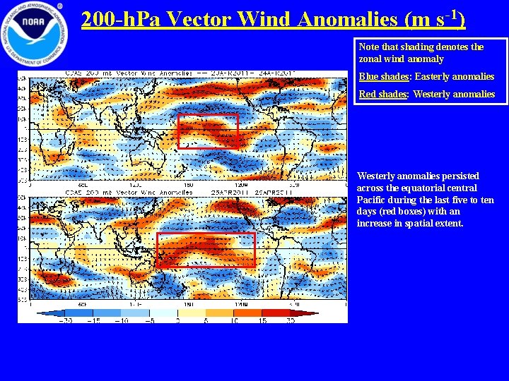
200 -h. Pa Vector Wind Anomalies (m s-1) Note that shading denotes the zonal wind anomaly Blue shades: Easterly anomalies Red shades: Westerly anomalies persisted across the equatorial central Pacific during the last five to ten days (red boxes) with an increase in spatial extent.

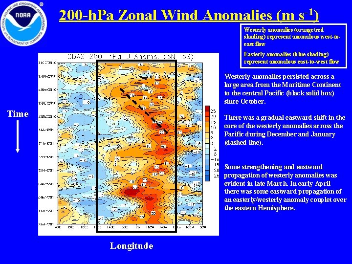
200 -h. Pa Zonal Wind Anomalies (m s-1) Westerly anomalies (orange/red shading) represent anomalous west-toeast flow Easterly anomalies (blue shading) represent anomalous east-to-west flow Westerly anomalies persisted across a large area from the Maritime Continent to the central Pacific (black solid box) since October. Time There was a gradual eastward shift in the core of the westerly anomalies across the Pacific during December and January (dashed line). Some strengthening and eastward propagation of westerly anomalies was evident in late March. In early April there was some eastward propagation of an easterly/westerly anomaly couplet over the eastern Hemisphere. Longitude

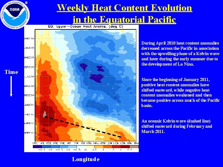
Weekly Heat Content Evolution in the Equatorial Pacific During April 2010 heat content anomalies decreased across the Pacific in association with the upwelling phase of a Kelvin wave and later during the early summer due to the development of La Nina. Time Since the beginning of January 2011, positive heat content anomalies have shifted eastward, while negative heat content anomalies weakened and then became positive across much of the Pacific basin. An oceanic Kelvin wave (dashed line) shifted eastward during February and March 2011. Longitude

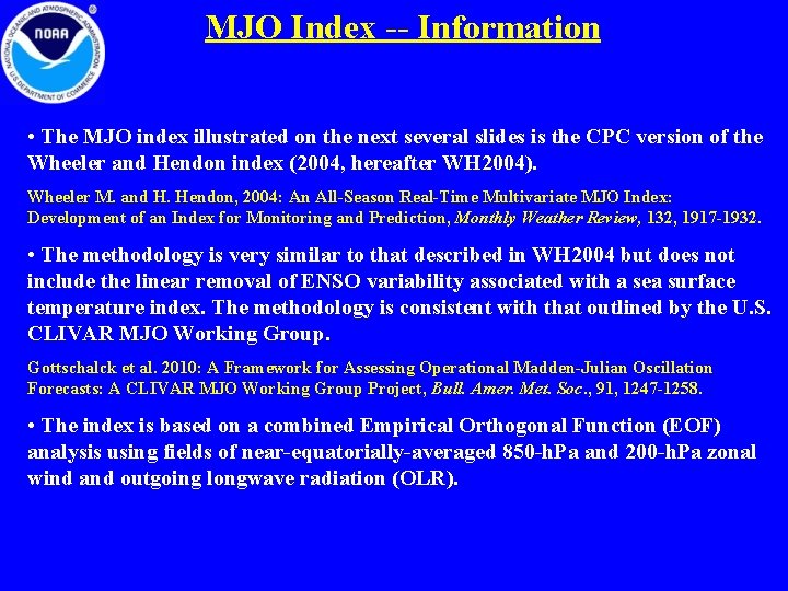
MJO Index -- Information • The MJO index illustrated on the next several slides is the CPC version of the Wheeler and Hendon index (2004, hereafter WH 2004). Wheeler M. and H. Hendon, 2004: An All-Season Real-Time Multivariate MJO Index: Development of an Index for Monitoring and Prediction, Monthly Weather Review, 132, 1917 -1932. • The methodology is very similar to that described in WH 2004 but does not include the linear removal of ENSO variability associated with a sea surface temperature index. The methodology is consistent with that outlined by the U. S. CLIVAR MJO Working Group. Gottschalck et al. 2010: A Framework for Assessing Operational Madden-Julian Oscillation Forecasts: A CLIVAR MJO Working Group Project, Bull. Amer. Met. Soc. , 91, 1247 -1258. • The index is based on a combined Empirical Orthogonal Function (EOF) analysis using fields of near-equatorially-averaged 850 -h. Pa and 200 -h. Pa zonal wind and outgoing longwave radiation (OLR).

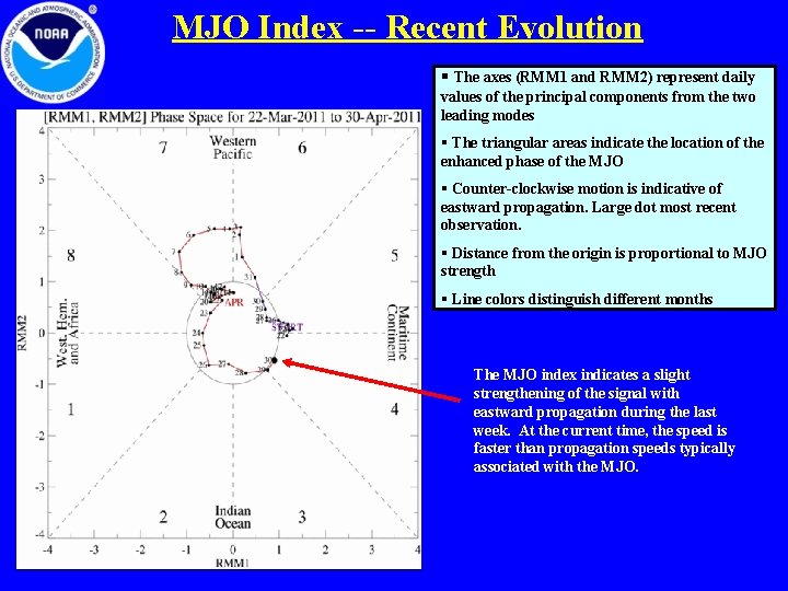
MJO Index -- Recent Evolution § The axes (RMM 1 and RMM 2) represent daily values of the principal components from the two leading modes § The triangular areas indicate the location of the enhanced phase of the MJO § Counter-clockwise motion is indicative of eastward propagation. Large dot most recent observation. § Distance from the origin is proportional to MJO strength § Line colors distinguish different months The MJO index indicates a slight strengthening of the signal with eastward propagation during the last week. At the current time, the speed is faster than propagation speeds typically associated with the MJO.

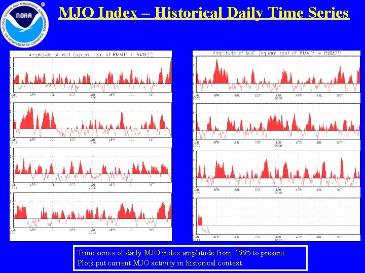
MJO Index – Historical Daily Time Series Time series of daily MJO index amplitude from 1995 to present. Plots put current MJO activity in historical context.

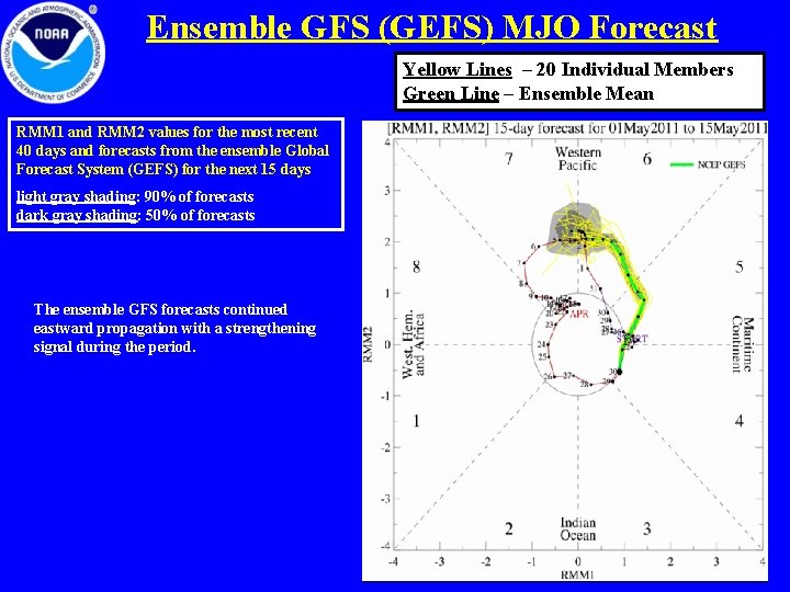
Ensemble GFS (GEFS) MJO Forecast Yellow Lines – 20 Individual Members Green Line – Ensemble Mean RMM 1 and RMM 2 values for the most recent 40 days and forecasts from the ensemble Global Forecast System (GEFS) for the next 15 days light gray shading: 90% of forecasts dark gray shading: 50% of forecasts The ensemble GFS forecasts continued eastward propagation with a strengthening signal during the period.

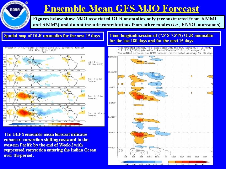
Ensemble Mean GFS MJO Forecast Figures below show MJO associated OLR anomalies only (reconstructed from RMM 1 and RMM 2) and do not include contributions from other modes (i. e. , ENSO, monsoons) Spatial map of OLR anomalies for the next 15 days The GEFS ensemble mean forecast indicates enhanced convection shifting eastward to the western Pacific by the end of Week-2 with suppressed convection entering the Indian Ocean over the period. Time-longitude section of (7. 5°S-7. 5°N) OLR anomalies for the last 180 days and for the next 15 days

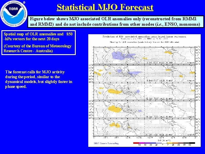
Statistical MJO Forecast Figure below shows MJO associated OLR anomalies only (reconstructed from RMM 1 and RMM 2) and do not include contributions from other modes (i. e. , ENSO, monsoons) Spatial map of OLR anomalies and 850 -h. Pa vectors for the next 20 days (Courtesy of the Bureau of Meteorology Research Centre - Australia) The forecast calls for MJO activity during the period, similar to the dynamical models, but slightly faster in phase speed.

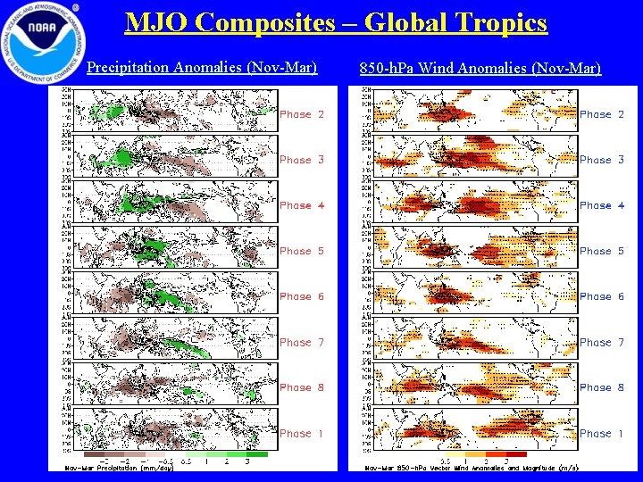
MJO Composites – Global Tropics Precipitation Anomalies (Nov-Mar) 850 -h. Pa Wind Anomalies (Nov-Mar)

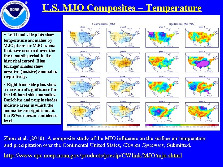
U. S. MJO Composites – Temperature § Left hand side plots show temperature anomalies by MJO phase for MJO events that have occurred over the three month period in the historical record. Blue (orange) shades show negative (positive) anomalies respectively. § Right hand side plots show a measure of significance for the left hand side anomalies. Dark blue and purple shades indicate areas in which the anomalies are significant at the 95% or better confidence level. Zhou et al. (2010): A composite study of the MJO influence on the surface air temperature and precipitation over the Continental United States, Climate Dynamics, Submitted. http: //www. cpc. ncep. noaa. gov/products/precip/CWlink/MJO/mjo. shtml

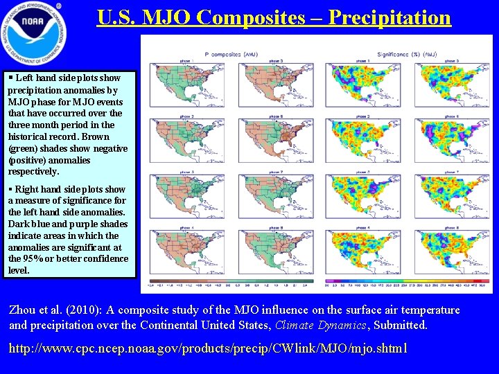
U. S. MJO Composites – Precipitation § Left hand side plots show precipitation anomalies by MJO phase for MJO events that have occurred over the three month period in the historical record. Brown (green) shades show negative (positive) anomalies respectively. § Right hand side plots show a measure of significance for the left hand side anomalies. Dark blue and purple shades indicate areas in which the anomalies are significant at the 95% or better confidence level. Zhou et al. (2010): A composite study of the MJO influence on the surface air temperature and precipitation over the Continental United States, Climate Dynamics, Submitted. http: //www. cpc. ncep. noaa. gov/products/precip/CWlink/MJO/mjo. shtml