MaddenJulian Oscillation Recent Evolution Current Status and Predictions
- Slides: 21

Madden-Julian Oscillation: Recent Evolution, Current Status and Predictions Update prepared by: Climate Prediction Center / NCEP 21 September 2015

Outline Overview Recent Evolution and Current Conditions MJO Index Information MJO Index Forecasts MJO Composites

Overview The MJO remained weak during the past week. Other types of variability, including the ongoing El Niño, remain the primary influences on the global tropical convective pattern. The consensus among dynamical and statistical models is that the ongoing El Niño remains the major contributor to anomalous convection. The MJO is not expected to play a major role in the pattern of tropical convection during the period. Additional potential impacts across the global tropics and a discussion for the U. S. are available at: http: //www. cpc. ncep. noaa. gov/products/precip/CWlink/ghazards/index. php

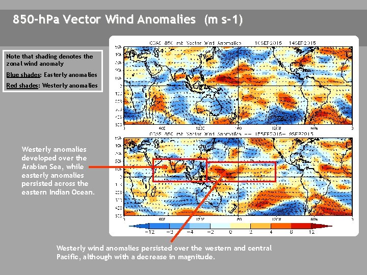
850 -h. Pa Vector Wind Anomalies (m s-1) Note that shading denotes the zonal wind anomaly Blue shades: Easterly anomalies Red shades: Westerly anomalies developed over the Arabian Sea, while easterly anomalies persisted across the eastern Indian Ocean. Westerly wind anomalies persisted over the western and central Pacific, although with a decrease in magnitude.

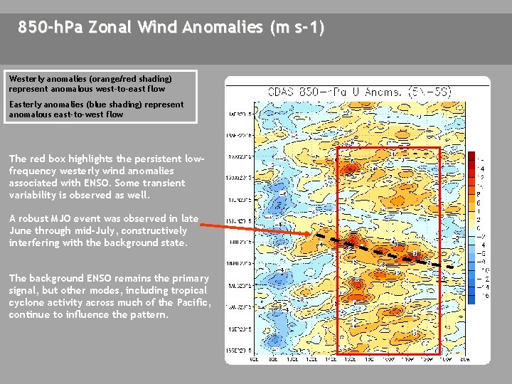
850 -h. Pa Zonal Wind Anomalies (m s-1) Westerly anomalies (orange/red shading) represent anomalous west-to-east flow Easterly anomalies (blue shading) represent anomalous east-to-west flow The red box highlights the persistent lowfrequency westerly wind anomalies associated with ENSO. Some transient variability is observed as well. A robust MJO event was observed in late June through mid-July, constructively interfering with the background state. The background ENSO remains the primary signal, but other modes, including tropical cyclone activity across much of the Pacific, continue to influence the pattern.

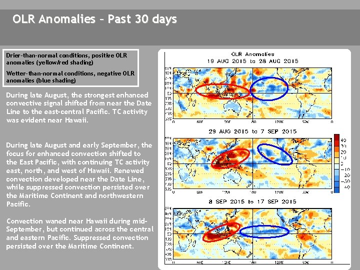
OLR Anomalies – Past 30 days Drier-than-normal conditions, positive OLR anomalies (yellow/red shading) Wetter-than-normal conditions, negative OLR anomalies (blue shading) During late August, the strongest enhanced convective signal shifted from near the Date Line to the east-central Pacific. TC activity was evident near Hawaii. During late August and early September, the focus for enhanced convection shifted to the East Pacific, with continuing TC activity east, north, and west of Hawaii. Renewed convection developed near the Date Line, while suppressed convection persisted over the Maritime Continent and northwestern Pacific. Convection waned near Hawaii during mid. September, but continued across the central and eastern Pacific. Suppressed convection persisted over the Maritime Continent.

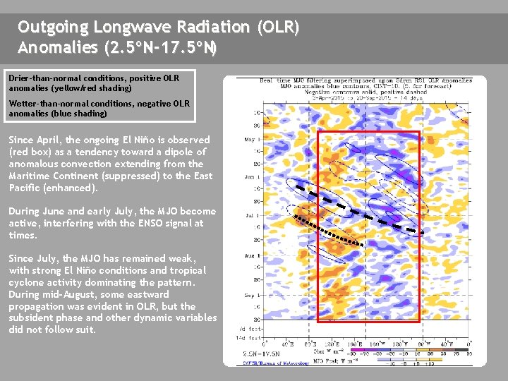
Outgoing Longwave Radiation (OLR) Anomalies (2. 5ºN-17. 5ºN) Drier-than-normal conditions, positive OLR anomalies (yellow/red shading) Wetter-than-normal conditions, negative OLR anomalies (blue shading) Since April, the ongoing El Niño is observed (red box) as a tendency toward a dipole of anomalous convection extending from the Maritime Continent (suppressed) to the East Pacific (enhanced). During June and early July, the MJO become active, interfering with the ENSO signal at times. Since July, the MJO has remained weak, with strong El Niño conditions and tropical cyclone activity dominating the pattern. During mid-August, some eastward propagation was evident in OLR, but the subsident phase and other dynamic variables did not follow suit.

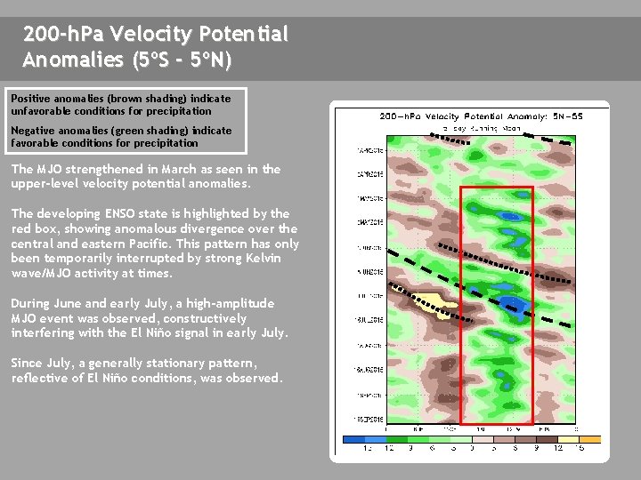
200 -h. Pa Velocity Potential Anomalies (5ºS - 5ºN) Positive anomalies (brown shading) indicate unfavorable conditions for precipitation Negative anomalies (green shading) indicate favorable conditions for precipitation The MJO strengthened in March as seen in the upper-level velocity potential anomalies. The developing ENSO state is highlighted by the red box, showing anomalous divergence over the central and eastern Pacific. This pattern has only been temporarily interrupted by strong Kelvin wave/MJO activity at times. During June and early July, a high-amplitude MJO event was observed, constructively interfering with the El Niño signal in early July. Since July, a generally stationary pattern, reflective of El Niño conditions, was observed.

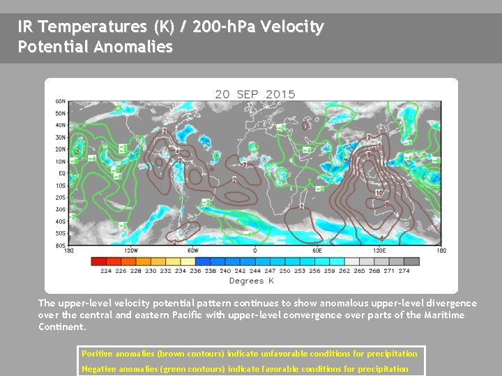
IR Temperatures (K) / 200 -h. Pa Velocity Potential Anomalies The upper-level velocity potential pattern continues to show anomalous upper-level divergence over the central and eastern Pacific with upper-level convergence over parts of the Maritime Continent. Positive anomalies (brown contours) indicate unfavorable conditions for precipitation Negative anomalies (green contours) indicate favorable conditions for precipitation

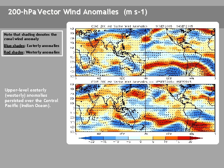
200 -h. Pa Vector Wind Anomalies (m s-1) Note that shading denotes the zonal wind anomaly Blue shades: Easterly anomalies Red shades: Westerly anomalies Upper-level easterly (westerly) anomalies persisted over the Central Pacific (Indian Ocean). A A

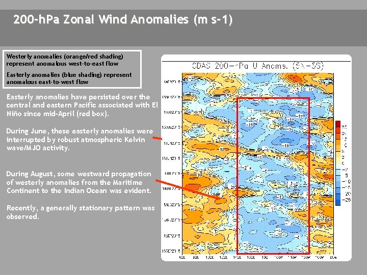
200 -h. Pa Zonal Wind Anomalies (m s-1) Westerly anomalies (orange/red shading) represent anomalous west-to-east flow Easterly anomalies (blue shading) represent anomalous east-to-west flow Easterly anomalies have persisted over the central and eastern Pacific associated with El Niño since mid-April (red box). During June, these easterly anomalies were interrupted by robust atmospheric Kelvin wave/MJO activity. During August, some westward propagation of westerly anomalies from the Maritime Continent to the Indian Ocean was evident. Recently, a generally stationary pattern was observed.

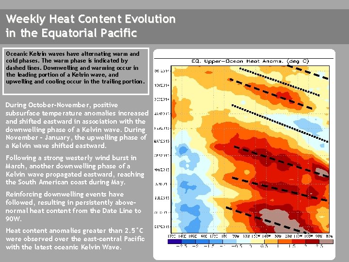
Weekly Heat Content Evolution in the Equatorial Pacific Oceanic Kelvin waves have alternating warm and cold phases. The warm phase is indicated by dashed lines. Downwelling and warming occur in the leading portion of a Kelvin wave, and upwelling and cooling occur in the trailing portion. During October-November, positive subsurface temperature anomalies increased and shifted eastward in association with the downwelling phase of a Kelvin wave. During November - January, the upwelling phase of a Kelvin wave shifted eastward. Following a strong westerly wind burst in March, another downwelling phase of a Kelvin wave propagated eastward, reaching the South American coast during May. Reinforcing downwelling events have followed, resulting in persistently abovenormal heat content from the Date Line to 90 W. Heat content anomalies greater than 2. 5°C were observed over the east-central Pacific with the latest oceanic Kelvin Wave.

MJO Index -- Information The MJO index illustrated on the next several slides is the CPC version of the Wheeler and Hendon index (2004, hereafter WH 2004). Wheeler M. and H. Hendon, 2004: An All-Season Real-Time Multivariate MJO Index: Development of an Index for Monitoring and Prediction, Monthly Weather Review, 132, 1917 -1932. The methodology is very similar to that described in WH 2004 but does not include the linear removal of ENSO variability associated with a sea surface temperature index. The methodology is consistent with that outlined by the U. S. CLIVAR MJO Working Group. Gottschalck et al. 2010: A Framework for Assessing Operational Madden-Julian Oscillation Forecasts: A CLIVAR MJO Working Group Project, Bull. Amer. Met. Soc. , 91, 1247 -1258. The index is based on a combined Empirical Orthogonal Function (EOF) analysis using fields of near-equatorially-averaged 850 -h. Pa and 200 -h. Pa zonal wind and outgoing longwave radiation (OLR).

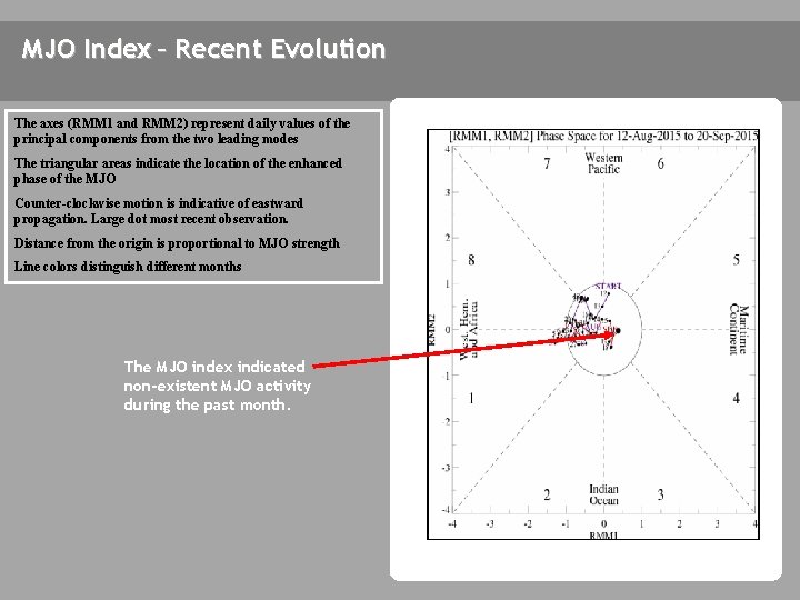
MJO Index – Recent Evolution The axes (RMM 1 and RMM 2) represent daily values of the principal components from the two leading modes The triangular areas indicate the location of the enhanced phase of the MJO Counter-clockwise motion is indicative of eastward propagation. Large dot most recent observation. Distance from the origin is proportional to MJO strength Line colors distinguish different months The MJO index indicated non-existent MJO activity during the past month.

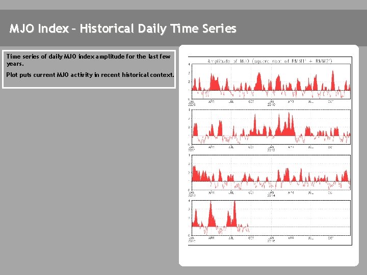
MJO Index – Historical Daily Time Series Time series of daily MJO index amplitude for the last few years. Plot puts current MJO activity in recent historical context.

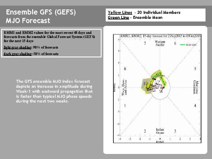
Ensemble GFS (GEFS) MJO Forecast RMM 1 and RMM 2 values for the most recent 40 days and forecasts from the ensemble Global Forecast System (GEFS) for the next 15 days light gray shading: 90% of forecasts dark gray shading: 50% of forecasts The GFS ensemble MJO index forecast depicts an increase in amplitude during Week-1 with eastward propagation that is faster than typical MJO phase speeds during the next two weeks. Yellow Lines – 20 Individual Members Green Line – Ensemble Mean

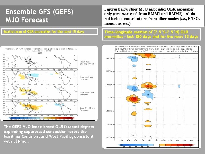
Ensemble GFS (GEFS) MJO Forecast Spatial map of OLR anomalies for the next 15 days The GEFS MJO index-based OLR forecast depicts expanding suppressed convection across the Maritime Continent and West Pacific, consistent with El Niño. Figures below show MJO associated OLR anomalies only (reconstructed from RMM 1 and RMM 2) and do not include contributions from other modes (i. e. , ENSO, monsoons, etc. ) Time-longitude section of (7. 5°S-7. 5°N) OLR anomalies - last 180 days and for the next 15 days

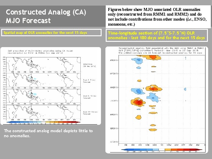
Constructed Analog (CA) MJO Forecast Figures below show MJO associated OLR anomalies only (reconstructed from RMM 1 and RMM 2) and do not include contributions from other modes (i. e. , ENSO, monsoons, etc. ) Spatial map of OLR anomalies for the next 15 days Time-longitude section of (7. 5°S-7. 5°N) OLR anomalies - last 180 days and for the next 15 days The constructed analog model depicts little to no anomalies.

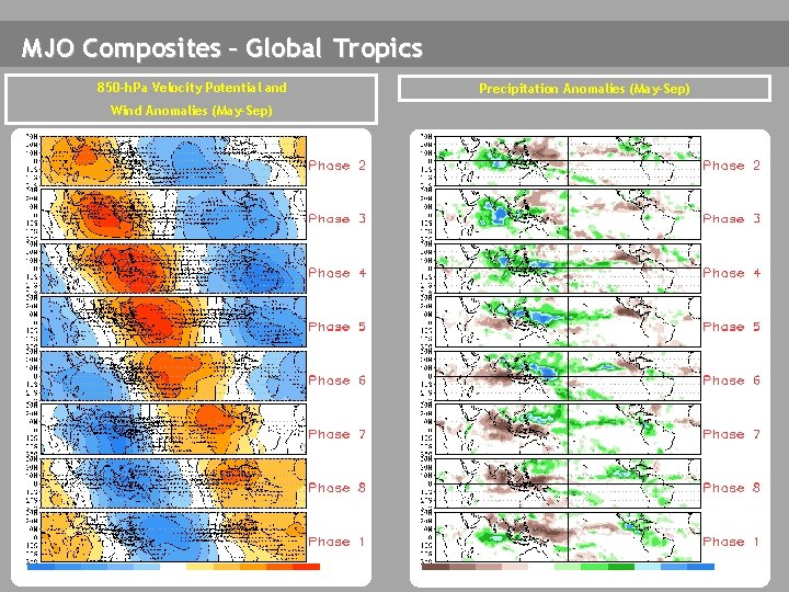
MJO Composites – Global Tropics 850 -h. Pa Velocity Potential and Wind Anomalies (May-Sep) Precipitation Anomalies (May-Sep)

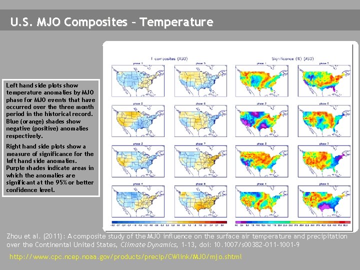
U. S. MJO Composites – Temperature Left hand side plots show temperature anomalies by MJO phase for MJO events that have occurred over the three month period in the historical record. Blue (orange) shades show negative (positive) anomalies respectively. Right hand side plots show a measure of significance for the left hand side anomalies. Purple shades indicate areas in which the anomalies are significant at the 95% or better confidence level. Zhou et al. (2011): A composite study of the MJO influence on the surface air temperature and precipitation over the Continental United States, Climate Dynamics, 1 -13, doi: 10. 1007/s 00382 -011 -1001 -9 http: //www. cpc. ncep. noaa. gov/products/precip/CWlink/MJO/mjo. shtml

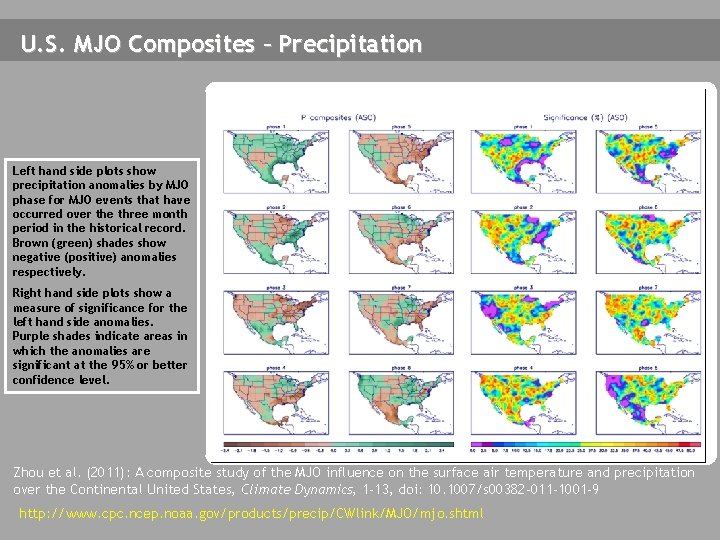
U. S. MJO Composites – Precipitation Left hand side plots show precipitation anomalies by MJO phase for MJO events that have occurred over the three month period in the historical record. Brown (green) shades show negative (positive) anomalies respectively. Right hand side plots show a measure of significance for the left hand side anomalies. Purple shades indicate areas in which the anomalies are significant at the 95% or better confidence level. Zhou et al. (2011): A composite study of the MJO influence on the surface air temperature and precipitation over the Continental United States, Climate Dynamics, 1 -13, doi: 10. 1007/s 00382 -011 -1001 -9 http: //www. cpc. ncep. noaa. gov/products/precip/CWlink/MJO/mjo. shtml