MaddenJulian Oscillation Recent Evolution Current Status and Predictions
- Slides: 21

Madden-Julian Oscillation: Recent Evolution, Current Status and Predictions Update prepared by: Climate Prediction Center / NCEP 19 September 2016

Outline Overview Recent Evolution and Current Conditions MJO Index Information MJO Index Forecasts MJO Composites

Overview The MJO indices indicated a strengthened MJO signal. The increased signal is related to increased coherence of the measured variables, though uncertainty about the signal maintaining structure while propagating eastward is moderate. Dynamical model forecasts of the RMM-based MJO index depict a continued signal over the Maritime Continent, though the strength and underlying cause are uncertain. Some models alias westward moving features into the MJO band while others propagate a coherent MJO signal to the western Pacific. A continued MJO signal is the most likely outcome through Week-1, with greater uncertainty after that. The interplay of the various modes of variability preclude statements about further out in time. Tropical cyclone formation is likely to be enhanced over the western Pacific, and to a lesser extent the Atlantic, through the rest of September. Additional potential impacts across the global tropics and a discussion for the U. S. are available at: http: //www. cpc. ncep. noaa. gov/products/precip/CWlink/ghazards/index. php

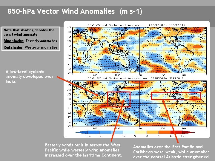
850 -h. Pa Vector Wind Anomalies (m s-1) Note that shading denotes the zonal wind anomaly Blue shades: Easterly anomalies Red shades: Westerly anomalies A low-level cyclonic anomaly developed over India. Easterly winds built in across the West Pacific while westerly wind anomalies increased over the Maritime Continent. Anomalies over the East Pacific and Caribbean were weak, while anomalies over the central Atlantic strengthened.

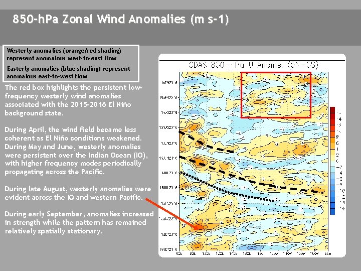
850 -h. Pa Zonal Wind Anomalies (m s-1) Westerly anomalies (orange/red shading) represent anomalous west-to-east flow Easterly anomalies (blue shading) represent anomalous east-to-west flow The red box highlights the persistent lowfrequency westerly wind anomalies associated with the 2015 -2016 El Niño background state. During April, the wind field became less coherent as El Niño conditions weakened. During May and June, westerly anomalies were persistent over the Indian Ocean (IO), with higher frequency modes periodically propagating across the Pacific. During late August, westerly anomalies were evident across the IO and western Pacific. During early September, anomalies increased in strength while the pattern has remained relatively spatially stationary.

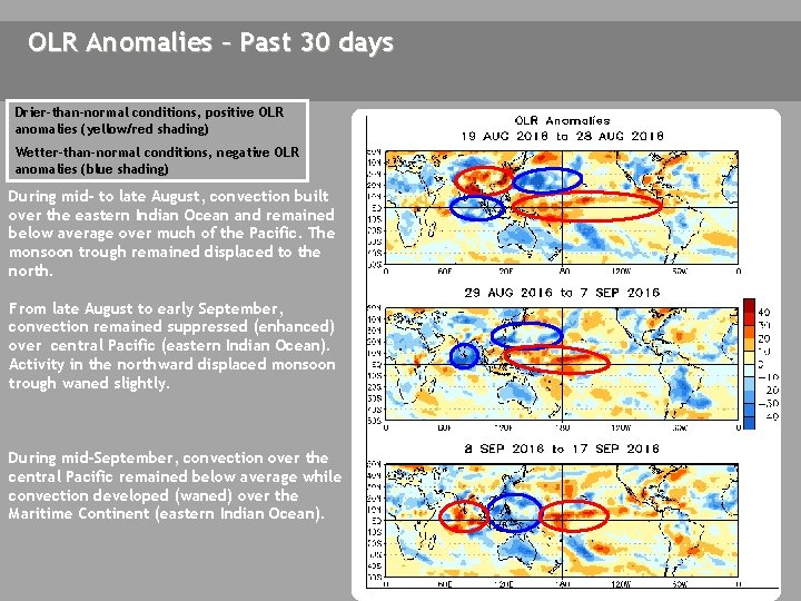
OLR Anomalies – Past 30 days Drier-than-normal conditions, positive OLR anomalies (yellow/red shading) Wetter-than-normal conditions, negative OLR anomalies (blue shading) During mid- to late August, convection built over the eastern Indian Ocean and remained below average over much of the Pacific. The monsoon trough remained displaced to the north. From late August to early September, convection remained suppressed (enhanced) over central Pacific (eastern Indian Ocean). Activity in the northward displaced monsoon trough waned slightly. During mid-September, convection over the central Pacific remained below average while convection developed (waned) over the Maritime Continent (eastern Indian Ocean).

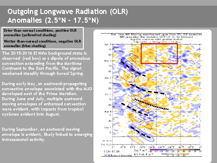
Outgoing Longwave Radiation (OLR) Anomalies (2. 5ºN - 17. 5ºN) Drier-than-normal conditions, positive OLR anomalies (yellow/red shading) Wetter-than-normal conditions, negative OLR anomalies (blue shading) The 2015 -2016 El Niño background state is observed (red box) as a dipole of anomalous convection extending from the Maritime Continent to the East Pacific. The signal weakened steadily through boreal Spring. During early May, an eastward-propagating convective envelope associated with the MJO developed east of the Prime Meridian. During June and July, multiple eastward moving envelopes of enhanced convection were evident, with impacts from tropical cyclones evident into August. During September, an eastward moving envelope is evident, likely linked to emerging intraseasonal activity.

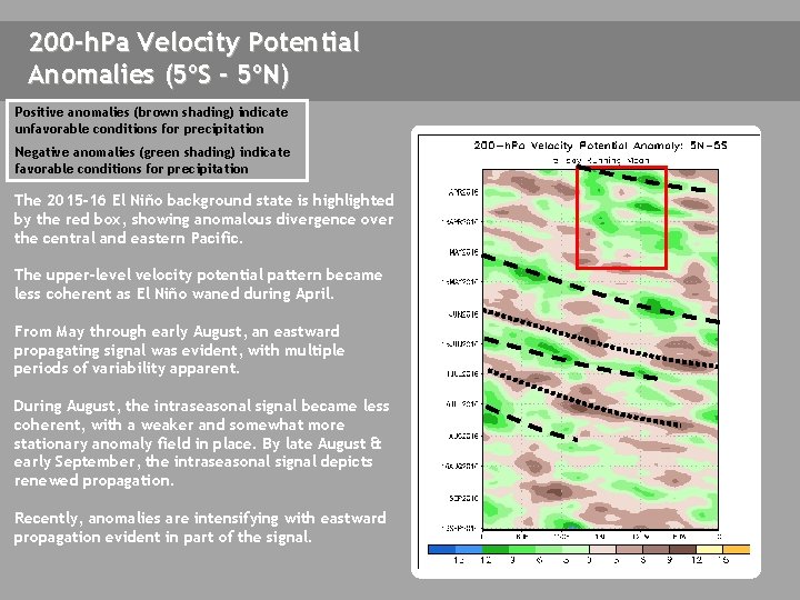
200 -h. Pa Velocity Potential Anomalies (5ºS - 5ºN) Positive anomalies (brown shading) indicate unfavorable conditions for precipitation Negative anomalies (green shading) indicate favorable conditions for precipitation The 2015 -16 El Niño background state is highlighted by the red box, showing anomalous divergence over the central and eastern Pacific. The upper-level velocity potential pattern became less coherent as El Niño waned during April. From May through early August, an eastward propagating signal was evident, with multiple periods of variability apparent. During August, the intraseasonal signal became less coherent, with a weaker and somewhat more stationary anomaly field in place. By late August & early September, the intraseasonal signal depicts renewed propagation. Recently, anomalies are intensifying with eastward propagation evident in part of the signal.

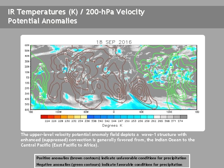
IR Temperatures (K) / 200 -h. Pa Velocity Potential Anomalies The upper-level velocity potential anomaly field depicts a wave-1 structure with enhanced (suppressed) convection is generally favored from, the Indian Ocean to the Central Pacific (East Pacific to Africa). Positive anomalies (brown contours) indicate unfavorable conditions for precipitation Negative anomalies (green contours) indicate favorable conditions for precipitation

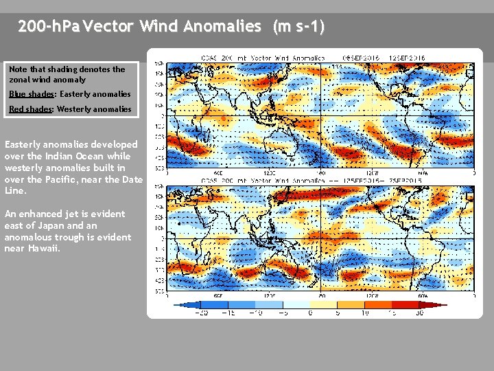
200 -h. Pa Vector Wind Anomalies (m s-1) Note that shading denotes the zonal wind anomaly Blue shades: Easterly anomalies Red shades: Westerly anomalies A A Easterly anomalies developed over the Indian Ocean while westerly anomalies built in over the Pacific, near the Date Line. An enhanced jet is evident east of Japan and an anomalous trough is evident near Hawaii. A A A

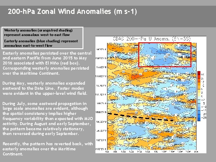
200 -h. Pa Zonal Wind Anomalies (m s-1) Westerly anomalies (orange/red shading) represent anomalous west-to-east flow Easterly anomalies (blue shading) represent anomalous east-to-west flow Easterly anomalies persisted over the central and eastern Pacific from June 2015 to May 2016 associated with El Niño (red box). Corresponding westerly anomalies persisted over the Maritime Continent. During May, westerly anomalies expanded eastward to the Date Line. Faster modes were evident in the upper-level wind field. During July, some eastward propagation in large scale anomalies are evident, although the spatial consistency implies higher frequency variability than expected with MJO activity. During August and early September, the pattern became relatively stationary, then reversed during early September. Recently, the pattern has reverted back, with easterly anomalies over the Maritime Continent.

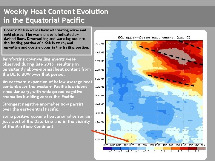
Weekly Heat Content Evolution in the Equatorial Pacific Oceanic Kelvin waves have alternating warm and cold phases. The warm phase is indicated by dashed lines. Downwelling and warming occur in the leading portion of a Kelvin wave, and upwelling and cooling occur in the trailing portion. Reinforcing downwelling events were observed during late 2015, resulting in persistently above-normal heat content from the DL to 80 W over that period. An eastward expansion of below average heat content over the western Pacific is evident since January, with widespread negative anomalies building across the Pacific. Strongest negative anomalies now persist over the east-central Pacific. Some positive oceanic heat anomalies remain just west of the Date Line and in the vicinity of the Maritime Continent.

MJO Index -- Information The MJO index illustrated on the next several slides is the CPC version of the Wheeler and Hendon index (2004, hereafter WH 2004). Wheeler M. and H. Hendon, 2004: An All-Season Real-Time Multivariate MJO Index: Development of an Index for Monitoring and Prediction, Monthly Weather Review, 132, 1917 -1932. The methodology is very similar to that described in WH 2004 but does not include the linear removal of ENSO variability associated with a sea surface temperature index. The methodology is consistent with that outlined by the U. S. CLIVAR MJO Working Group. Gottschalck et al. 2010: A Framework for Assessing Operational Madden-Julian Oscillation Forecasts: A CLIVAR MJO Working Group Project, Bull. Amer. Met. Soc. , 91, 1247 -1258. The index is based on a combined Empirical Orthogonal Function (EOF) analysis using fields of near-equatorially-averaged 850 -h. Pa and 200 -h. Pa zonal wind and outgoing longwave radiation (OLR).

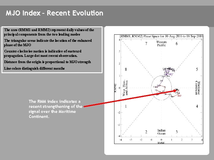
MJO Index – Recent Evolution The axes (RMM 1 and RMM 2) represent daily values of the principal components from the two leading modes The triangular areas indicate the location of the enhanced phase of the MJO Counter-clockwise motion is indicative of eastward propagation. Large dot most recent observation. Distance from the origin is proportional to MJO strength Line colors distinguish different months The RMM index indicates a recent strengthening of the signal over the Maritime Continent.

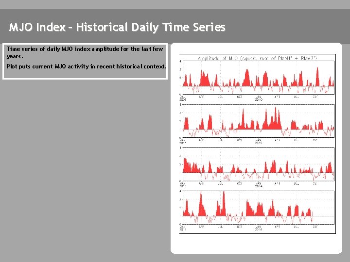
MJO Index – Historical Daily Time Series Time series of daily MJO index amplitude for the last few years. Plot puts current MJO activity in recent historical context.

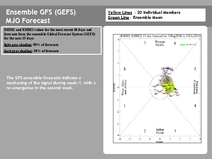
Ensemble GFS (GEFS) MJO Forecast RMM 1 and RMM 2 values for the most recent 40 days and forecasts from the ensemble Global Forecast System (GEFS) for the next 15 days light gray shading: 90% of forecasts dark gray shading: 50% of forecasts The GFS ensemble forecasts indicate a weakening of the signal during week-1, with a re-emergence in the second week. Yellow Lines – 20 Individual Members Green Line – Ensemble Mean

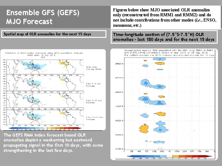
Ensemble GFS (GEFS) MJO Forecast Spatial map of OLR anomalies for the next 15 days The GEFS plot of MJO related OLR anomalies is unavailable at this time. The GEFS RMM Index forecast based OLR anomalies depict a weakening but eastward propagating signal in the first 10 days, with some strengthening in the last few days. Figures below show MJO associated OLR anomalies only (reconstructed from RMM 1 and RMM 2) and do not include contributions from other modes (i. e. , ENSO, monsoons, etc. ) Time-longitude section of (7. 5°S-7. 5°N) OLR anomalies - last 180 days and for the next 15 days The GEFS plot of MJO related OLR anomalies is unavailable at this time.

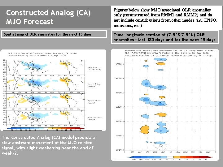
Constructed Analog (CA) MJO Forecast Figures below show MJO associated OLR anomalies only (reconstructed from RMM 1 and RMM 2) and do not include contributions from other modes (i. e. , ENSO, monsoons, etc. ) Spatial map of OLR anomalies for the next 15 days Time-longitude section of (7. 5°S-7. 5°N) OLR anomalies - last 180 days and for the next 15 days The Constructed Analog (CA) model predicts a slow eastward movement of the MJO related signal, with slight weakening near the end of week-2.

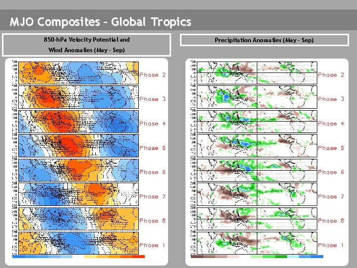
MJO Composites – Global Tropics 850 -h. Pa Velocity Potential and Wind Anomalies (May - Sep) Precipitation Anomalies (May - Sep)

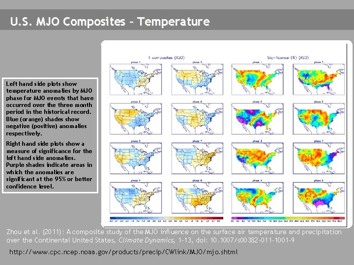
U. S. MJO Composites – Temperature Left hand side plots show temperature anomalies by MJO phase for MJO events that have occurred over the three month period in the historical record. Blue (orange) shades show negative (positive) anomalies respectively. Right hand side plots show a measure of significance for the left hand side anomalies. Purple shades indicate areas in which the anomalies are significant at the 95% or better confidence level. Zhou et al. (2011): A composite study of the MJO influence on the surface air temperature and precipitation over the Continental United States, Climate Dynamics, 1 -13, doi: 10. 1007/s 00382 -011 -1001 -9 http: //www. cpc. ncep. noaa. gov/products/precip/CWlink/MJO/mjo. shtml

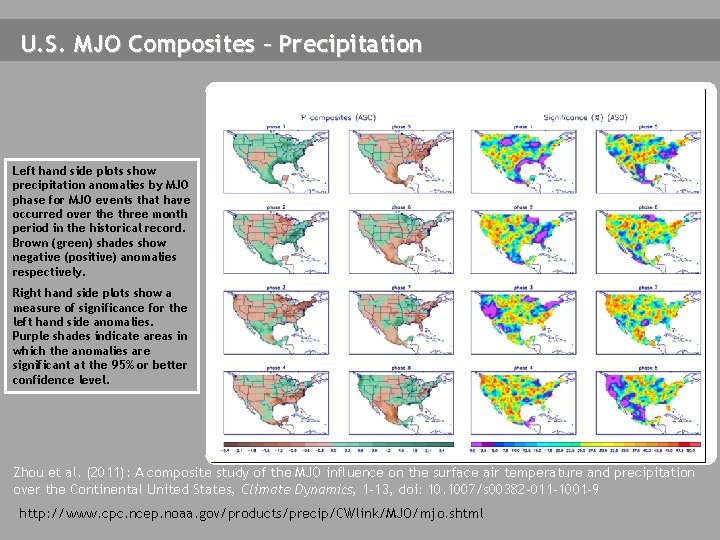
U. S. MJO Composites – Precipitation Left hand side plots show precipitation anomalies by MJO phase for MJO events that have occurred over the three month period in the historical record. Brown (green) shades show negative (positive) anomalies respectively. Right hand side plots show a measure of significance for the left hand side anomalies. Purple shades indicate areas in which the anomalies are significant at the 95% or better confidence level. Zhou et al. (2011): A composite study of the MJO influence on the surface air temperature and precipitation over the Continental United States, Climate Dynamics, 1 -13, doi: 10. 1007/s 00382 -011 -1001 -9 http: //www. cpc. ncep. noaa. gov/products/precip/CWlink/MJO/mjo. shtml