MaddenJulian Oscillation Recent Evolution Current Status and Predictions
- Slides: 21

Madden-Julian Oscillation: Recent Evolution, Current Status and Predictions Update prepared by: Climate Prediction Center / NCEP 5 June 2017

Outline Overview Recent Evolution and Current Conditions MJO Index Information MJO Index Forecasts MJO Composites

Overview Both the RMM and CPC velocity potential-based MJO indices depicted an MJO signal during the past week over the eastern Indian Ocean and Maritime Continent region. Most dynamical models predict a weak, incoherent signal during Week-1, and the possible re-emergence of a more substantial intraseasonal signal over the Indian Ocean during Week-2. Other modes of tropical variability (especially kelvin waves) are also likely to influence the pattern over the global tropics. Additional potential impacts across the global tropics and a discussion for the U. S. are available at: http: //www. cpc. ncep. noaa. gov/products/precip/CWlink/ghazards/index. php

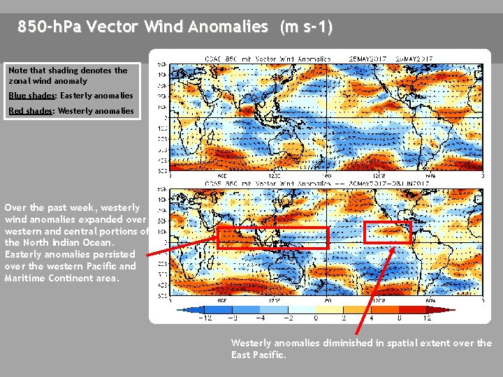
850 -h. Pa Vector Wind Anomalies (m s-1) Note that shading denotes the zonal wind anomaly Blue shades: Easterly anomalies Red shades: Westerly anomalies Over the past week, westerly wind anomalies expanded over western and central portions of the North Indian Ocean. Easterly anomalies persisted over the western Pacific and Maritime Continent area. Westerly anomalies diminished in spatial extent over the East Pacific.

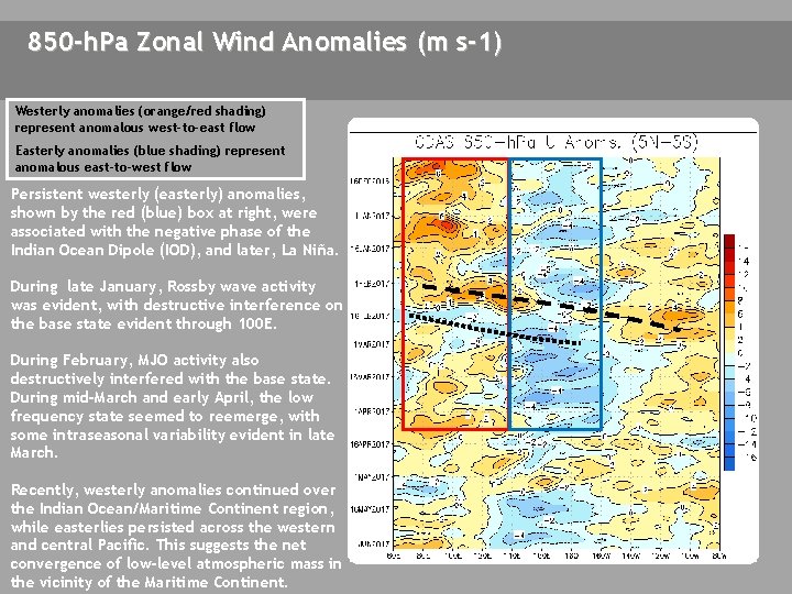
850 -h. Pa Zonal Wind Anomalies (m s-1) Westerly anomalies (orange/red shading) represent anomalous west-to-east flow Easterly anomalies (blue shading) represent anomalous east-to-west flow Persistent westerly (easterly) anomalies, shown by the red (blue) box at right, were associated with the negative phase of the Indian Ocean Dipole (IOD), and later, La Niña. During late January, Rossby wave activity was evident, with destructive interference on the base state evident through 100 E. During February, MJO activity also destructively interfered with the base state. During mid-March and early April, the low frequency state seemed to reemerge, with some intraseasonal variability evident in late March. Recently, westerly anomalies continued over the Indian Ocean/Maritime Continent region, while easterlies persisted across the western and central Pacific. This suggests the net convergence of low-level atmospheric mass in the vicinity of the Maritime Continent.

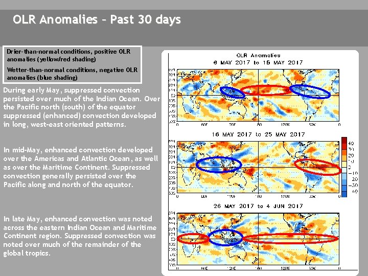
OLR Anomalies – Past 30 days Drier-than-normal conditions, positive OLR anomalies (yellow/red shading) Wetter-than-normal conditions, negative OLR anomalies (blue shading) During early May, suppressed convection persisted over much of the Indian Ocean. Over the Pacific north (south) of the equator suppressed (enhanced) convection developed in long, west-east oriented patterns. In mid-May, enhanced convection developed over the Americas and Atlantic Ocean, as well as over the Maritime Continent. Suppressed convection generally persisted over the Pacific along and north of the equator. In late May, enhanced convection was noted across the eastern Indian Ocean and Maritime Continent region. Suppressed convection was noted over much of the remainder of the global tropics.

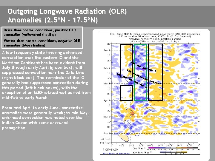
Outgoing Longwave Radiation (OLR) Anomalies (2. 5ºN - 17. 5ºN) Drier-than-normal conditions, positive OLR anomalies (yellow/red shading) Wetter-than-normal conditions, negative OLR anomalies (blue shading) A low frequency state favoring enhanced convection over the eastern IO and the Maritime Continent has been evident from July through early April (green box), with suppressed convection near the Date Line (right black box). The remainder of the IO generally had suppressed convection during this period (left black boxes), with the exception of an MJO-related wet period from mid-Feb to early March. From mid-April to early June, convective anomalies were generally weak; in mid-May, enhanced convection was noted over the Indian Ocean with some eastward propagation.

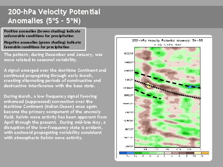
200 -h. Pa Velocity Potential Anomalies (5ºS - 5ºN) Positive anomalies (brown shading) indicate unfavorable conditions for precipitation Negative anomalies (green shading) indicate favorable conditions for precipitation The pattern, during December and January, was more related to seasonal variability. A signal emerged over the Maritime Continent and continued propagating through early March, creating alternating periods of constructive and destructive interference with the base state. During March, a low frequency signal favoring enhanced (suppressed) convection over the Maritime Continent (Indian Ocean) once again became the primary component of the anomaly field. Kelvin wave activity has been apparent from April through the present. During mid-late May, a disruption of the low-frequency state is evident, with eastward propagating variability consistent with atmospheric Kelvin wave activity.

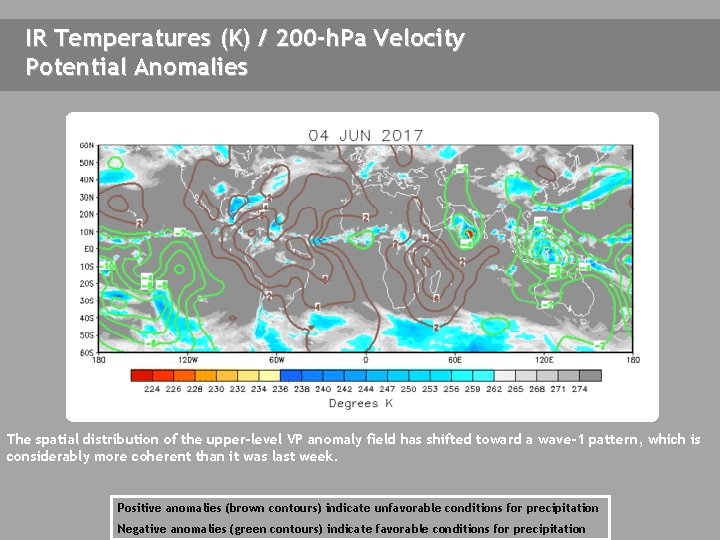
IR Temperatures (K) / 200 -h. Pa Velocity Potential Anomalies The spatial distribution of the upper-level VP anomaly field has shifted toward a wave-1 pattern, which is considerably more coherent than it was last week. Positive anomalies (brown contours) indicate unfavorable conditions for precipitation Negative anomalies (green contours) indicate favorable conditions for precipitation

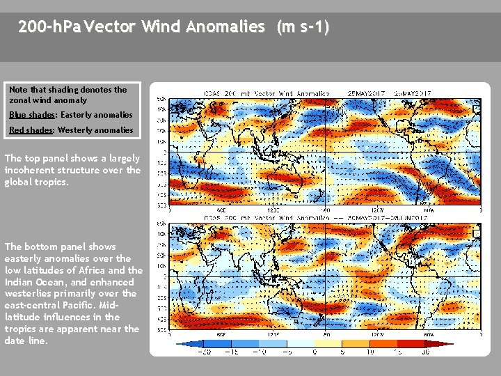
200 -h. Pa Vector Wind Anomalies (m s-1) Note that shading denotes the zonal wind anomaly Blue shades: Easterly anomalies Red shades: Westerly anomalies A The top panel shows a largely incoherent structure over the global tropics. The bottom panel shows easterly anomalies over the low latitudes of Africa and the Indian Ocean, and enhanced westerlies primarily over the east-central Pacific. Midlatitude influences in the tropics are apparent near the date line. C C

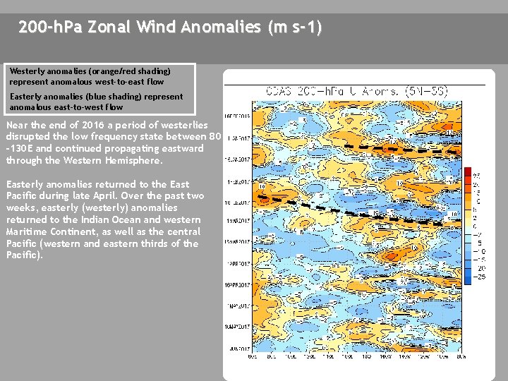
200 -h. Pa Zonal Wind Anomalies (m s-1) Westerly anomalies (orange/red shading) represent anomalous west-to-east flow Easterly anomalies (blue shading) represent anomalous east-to-west flow Near the end of 2016 a period of westerlies disrupted the low frequency state between 80 -130 E and continued propagating eastward through the Western Hemisphere. Easterly anomalies returned to the East Pacific during late April. Over the past two weeks, easterly (westerly) anomalies returned to the Indian Ocean and western Maritime Continent, as well as the central Pacific (western and eastern thirds of the Pacific).

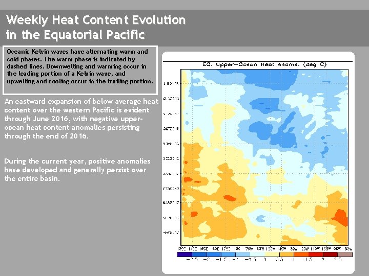
Weekly Heat Content Evolution in the Equatorial Pacific Oceanic Kelvin waves have alternating warm and cold phases. The warm phase is indicated by dashed lines. Downwelling and warming occur in the leading portion of a Kelvin wave, and upwelling and cooling occur in the trailing portion. An eastward expansion of below average heat content over the western Pacific is evident through June 2016, with negative upperocean heat content anomalies persisting through the end of 2016. During the current year, positive anomalies have developed and generally persist over the entire basin.

MJO Index -- Information The MJO index illustrated on the next several slides is the CPC version of the Wheeler and Hendon index (2004, hereafter WH 2004). Wheeler M. and H. Hendon, 2004: An All-Season Real-Time Multivariate MJO Index: Development of an Index for Monitoring and Prediction, Monthly Weather Review, 132, 1917 -1932. The methodology is very similar to that described in WH 2004 but does not include the linear removal of ENSO variability associated with a sea surface temperature index. The methodology is consistent with that outlined by the U. S. CLIVAR MJO Working Group. Gottschalck et al. 2010: A Framework for Assessing Operational Madden-Julian Oscillation Forecasts: A CLIVAR MJO Working Group Project, Bull. Amer. Met. Soc. , 91, 1247 -1258. The index is based on a combined Empirical Orthogonal Function (EOF) analysis using fields of near-equatorially-averaged 850 -h. Pa and 200 -h. Pa zonal wind and outgoing longwave radiation (OLR).

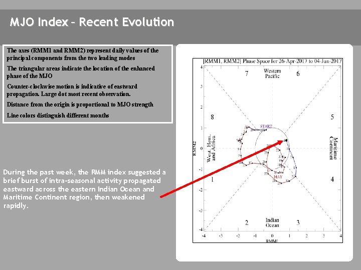
MJO Index – Recent Evolution The axes (RMM 1 and RMM 2) represent daily values of the principal components from the two leading modes The triangular areas indicate the location of the enhanced phase of the MJO Counter-clockwise motion is indicative of eastward propagation. Large dot most recent observation. Distance from the origin is proportional to MJO strength Line colors distinguish different months During the past week, the RMM index suggested a brief burst of intra-seasonal activity propagated eastward across the eastern Indian Ocean and Maritime Continent region, then weakened rapidly.

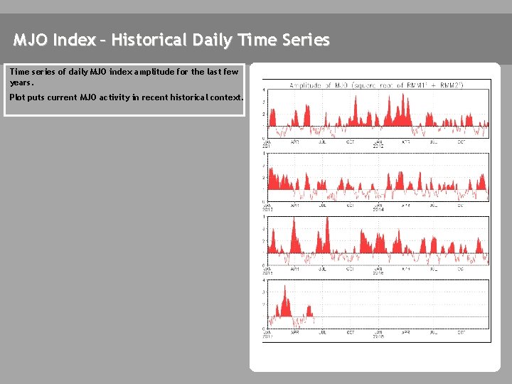
MJO Index – Historical Daily Time Series Time series of daily MJO index amplitude for the last few years. Plot puts current MJO activity in recent historical context.

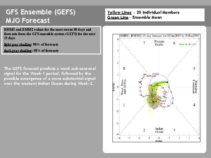
GFS Ensemble (GEFS) MJO Forecast RMM 1 and RMM 2 values for the most recent 40 days and forecasts from the GFS ensemble system (GEFS) for the next 15 days light gray shading: 90% of forecasts dark gray shading: 50% of forecasts The GEFS forecast predicts a weak sub-seasonal signal for the Week-1 period, followed by the possible emergence of a more substantial signal over the western Indian Ocean during Week-2. Yellow Lines – 20 Individual Members Green Line – Ensemble Mean

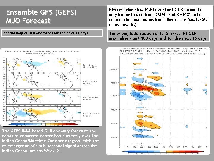
Ensemble GFS (GEFS) MJO Forecast Spatial map of OLR anomalies for the next 15 days The GEFS plot of MJO related OLR anomalies is unavailable at this time. The GEFS RMM-based OLR anomaly forecasts the decay of enhanced convection currently over the Indian Ocean/Maritime Continent region; with the re-emergence of a sub-seasonal signal across the Indian Ocean later in Week-2. Figures below show MJO associated OLR anomalies only (reconstructed from RMM 1 and RMM 2) and do not include contributions from other modes (i. e. , ENSO, monsoons, etc. ) Time-longitude section of (7. 5°S-7. 5°N) OLR anomalies - last 180 days and for the next 15 days The GEFS plot of MJO related OLR anomalies is unavailable at this time.

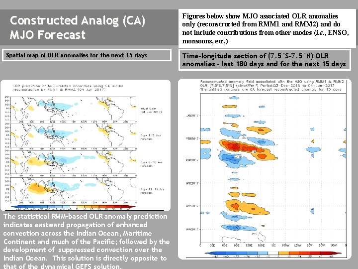
Constructed Analog (CA) MJO Forecast Figures below show MJO associated OLR anomalies only (reconstructed from RMM 1 and RMM 2) and do not include contributions from other modes (i. e. , ENSO, monsoons, etc. ) Spatial map of OLR anomalies for the next 15 days Time-longitude section of (7. 5°S-7. 5°N) OLR anomalies - last 180 days and for the next 15 days The statistical RMM-based OLR anomaly prediction indicates eastward propagation of enhanced convection across the Indian Ocean, Maritime Continent and much of the Pacific; followed by the development of suppressed convection over the Indian Ocean. This solution is directly opposite to that of the dynamical GEFS solution.

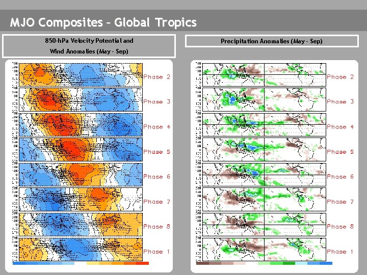
MJO Composites – Global Tropics 850 -h. Pa Velocity Potential and Wind Anomalies (May - Sep) Precipitation Anomalies (May - Sep)

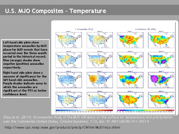
U. S. MJO Composites – Temperature Left hand side plots show temperature anomalies by MJO phase for MJO events that have occurred over the three month period in the historical record. Blue (orange) shades show negative (positive) anomalies respectively. Right hand side plots show a measure of significance for the left hand side anomalies. Purple shades indicate areas in which the anomalies are significant at the 95% or better confidence level. Zhou et al. (2011): A composite study of the MJO influence on the surface air temperature and precipitation over the Continental United States, Climate Dynamics, 1 -13, doi: 10. 1007/s 00382 -011 -1001 -9 http: //www. cpc. ncep. noaa. gov/products/precip/CWlink/MJO/mjo. shtml

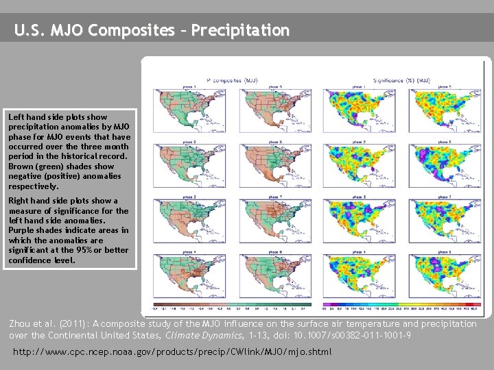
U. S. MJO Composites – Precipitation Left hand side plots show precipitation anomalies by MJO phase for MJO events that have occurred over the three month period in the historical record. Brown (green) shades show negative (positive) anomalies respectively. Right hand side plots show a measure of significance for the left hand side anomalies. Purple shades indicate areas in which the anomalies are significant at the 95% or better confidence level. Zhou et al. (2011): A composite study of the MJO influence on the surface air temperature and precipitation over the Continental United States, Climate Dynamics, 1 -13, doi: 10. 1007/s 00382 -011 -1001 -9 http: //www. cpc. ncep. noaa. gov/products/precip/CWlink/MJO/mjo. shtml