MaddenJulian Oscillation Recent Evolution Current Status and Predictions
- Slides: 21

Madden-Julian Oscillation: Recent Evolution, Current Status and Predictions Update prepared by: Climate Prediction Center / NCEP 9 January 2017

Outline Overview Recent Evolution and Current Conditions MJO Index Information MJO Index Forecasts MJO Composites

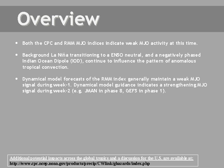
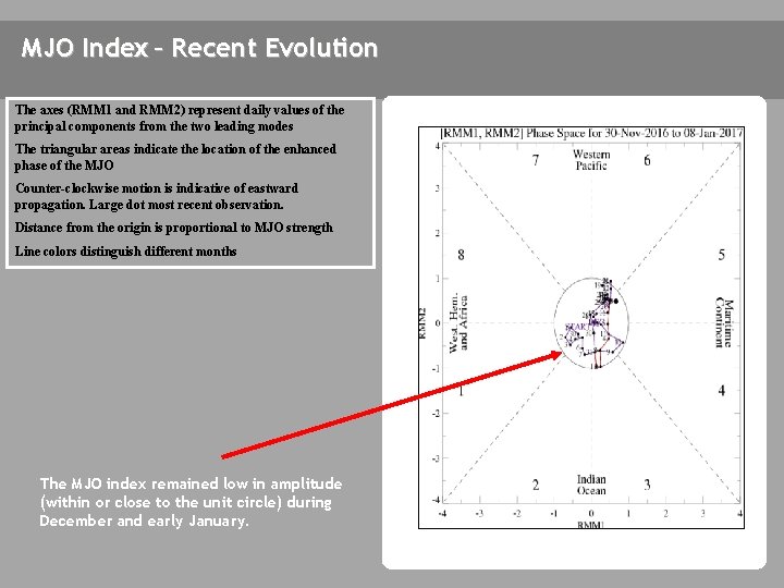
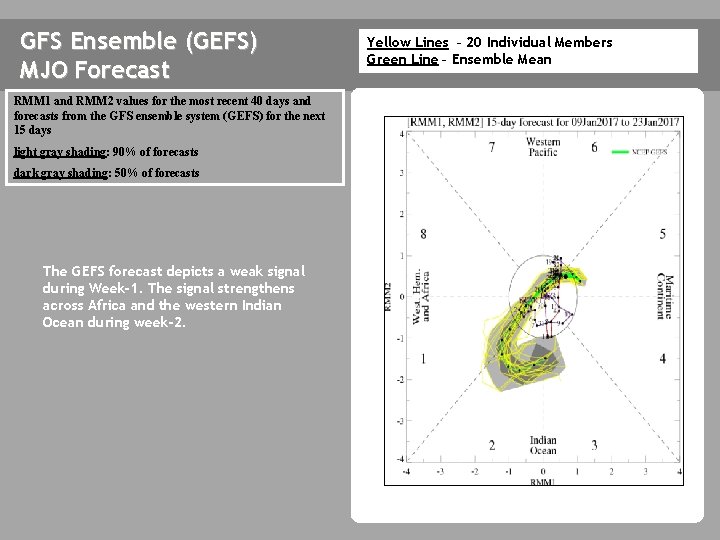
Overview Both the CPC and RMM MJO indices indicate weak MJO activity at this time. Background La Niña transitioning to a ENSO neutral, and a negatively phased Indian Ocean Dipole (IOD), continue to influence the pattern of anomalous tropical convection. Dynamical model forecasts of the RMM index generally maintain a weak MJO signal during week-1. Dynamical model guidance indicates a strengthening MJO signal during week-2 (e. g. JMAN in phase 8, GEFS in phase 1). Additional potential impacts across the global tropics and a discussion for the U. S. are available at: http: //www. cpc. ncep. noaa. gov/products/precip/CWlink/ghazards/index. php

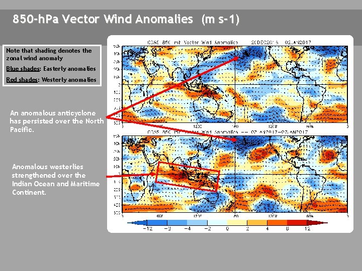
850 -h. Pa Vector Wind Anomalies (m s-1) Note that shading denotes the zonal wind anomaly A Blue shades: Easterly anomalies Red shades: Westerly anomalies An anomalous anticyclone has persisted over the North Pacific. A Anomalous westerlies strengthened over the Indian Ocean and Maritime Continent.

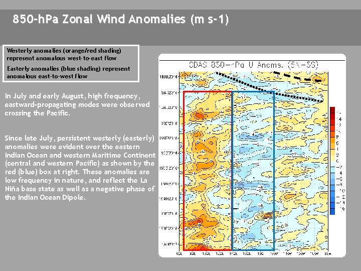
850 -h. Pa Zonal Wind Anomalies (m s-1) Westerly anomalies (orange/red shading) represent anomalous west-to-east flow Easterly anomalies (blue shading) represent anomalous east-to-west flow In July and early August, high frequency, eastward-propagating modes were observed crossing the Pacific. Since late July, persistent westerly (easterly) anomalies were evident over the eastern Indian Ocean and western Maritime Continent (central and western Pacific) as shown by the red (blue) box at right. These anomalies are low frequency in nature, and reflect the La Niña base state as well as a negative phase of the Indian Ocean Dipole.

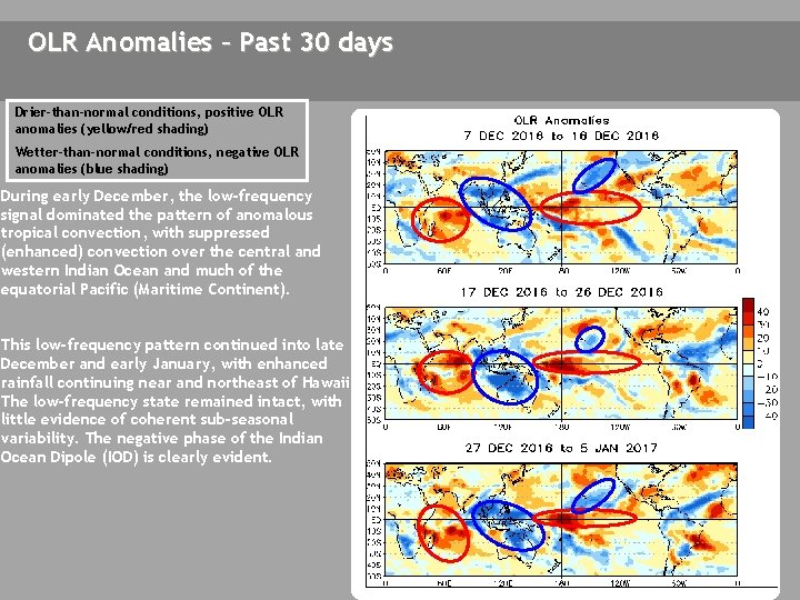
OLR Anomalies – Past 30 days Drier-than-normal conditions, positive OLR anomalies (yellow/red shading) Wetter-than-normal conditions, negative OLR anomalies (blue shading) During early December, the low-frequency signal dominated the pattern of anomalous tropical convection, with suppressed (enhanced) convection over the central and western Indian Ocean and much of the equatorial Pacific (Maritime Continent). This low-frequency pattern continued into late December and early January, with enhanced rainfall continuing near and northeast of Hawaii. The low-frequency state remained intact, with little evidence of coherent sub-seasonal variability. The negative phase of the Indian Ocean Dipole (IOD) is clearly evident.

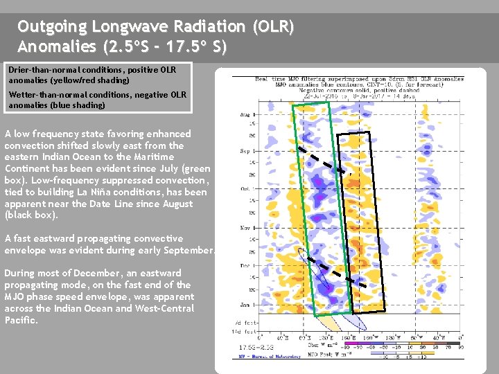
Outgoing Longwave Radiation (OLR) Anomalies (2. 5ºS - 17. 5º S) Drier-than-normal conditions, positive OLR anomalies (yellow/red shading) Wetter-than-normal conditions, negative OLR anomalies (blue shading) A low frequency state favoring enhanced convection shifted slowly east from the eastern Indian Ocean to the Maritime Continent has been evident since July (green box). Low-frequency suppressed convection, tied to building La Niña conditions, has been apparent near the Date Line since August (black box). A fast eastward propagating convective envelope was evident during early September. During most of December, an eastward propagating mode, on the fast end of the MJO phase speed envelope, was apparent across the Indian Ocean and West-Central Pacific.

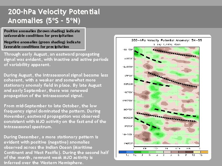
200 -h. Pa Velocity Potential Anomalies (5ºS - 5ºN) Positive anomalies (brown shading) indicate unfavorable conditions for precipitation Negative anomalies (green shading) indicate favorable conditions for precipitation Through early August, an eastward propagating signal was evident, with inactive and active periods of variability apparent. During August, the intraseasonal signal became less coherent, with a weaker and somewhat more stationary anomaly field in place. By late August and early September, there was renewed propagation of the intraseasonal signal. From mid-September to late October, the low frequency signal dominated the pattern. During November, eastward propagation was observed consistent with MJO activity on the fast end of the intraseasonal spectrum. During December, a more stationary pattern is evident with positive (negative) anomalies observed across the Indian Ocean (Maritime Continent and West Pacific). During the second half of the month, remnant weak MJO activity is inferred over the Western Hemisphere.

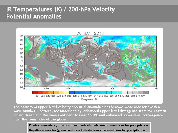
IR Temperatures (K) / 200 -h. Pa Velocity Potential Anomalies The pattern of upper-level velocity potential anomalies has become more coherent with a wave number 1 pattern, characterized by enhanced upper-level divergence from the eastern Indian Ocean and Maritime Continent to near 150 W, and enhanced upper-level convergence over the remainder of the globe. Positive anomalies (brown contours) indicate unfavorable conditions for precipitation Negative anomalies (green contours) indicate favorable conditions for precipitation

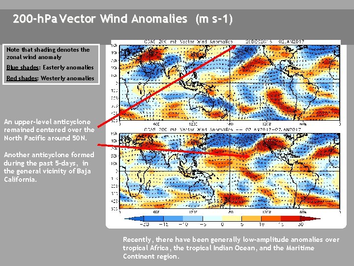
200 -h. Pa Vector Wind Anomalies (m s-1) Note that shading denotes the zonal wind anomaly Blue shades: Easterly anomalies Red shades: Westerly anomalies An upper-level anticyclone remained centered over the North Pacific around 50 N. Another anticyclone formed during the past 5 -days, in the general vicinity of Baja California. Recently, there have been generally low-amplitude anomalies over tropical Africa, the tropical Indian Ocean, and the Maritime Continent region.

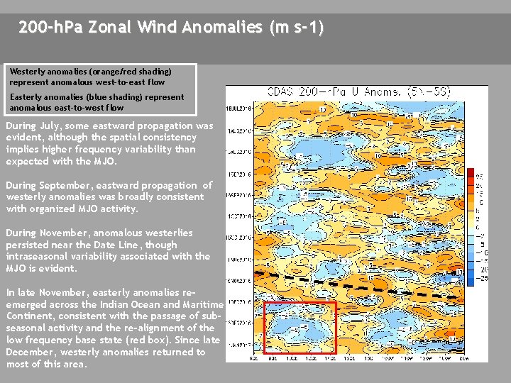
200 -h. Pa Zonal Wind Anomalies (m s-1) Westerly anomalies (orange/red shading) represent anomalous west-to-east flow Easterly anomalies (blue shading) represent anomalous east-to-west flow During July, some eastward propagation was evident, although the spatial consistency implies higher frequency variability than expected with the MJO. During September, eastward propagation of westerly anomalies was broadly consistent with organized MJO activity. During November, anomalous westerlies persisted near the Date Line, though intraseasonal variability associated with the MJO is evident. In late November, easterly anomalies reemerged across the Indian Ocean and Maritime Continent, consistent with the passage of subseasonal activity and the re-alignment of the low frequency base state (red box). Since late December, westerly anomalies returned to most of this area.

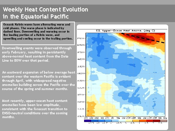
Weekly Heat Content Evolution in the Equatorial Pacific Oceanic Kelvin waves have alternating warm and cold phases. The warm phase is indicated by dashed lines. Downwelling and warming occur in the leading portion of a Kelvin wave, and upwelling and cooling occur in the trailing portion. Downwelling events were observed through early February, resulting in persistently above-normal heat content from the Date Line to 80 W over that period. An eastward expansion of below average heat content over the western Pacific is evident through April, with widespread negative anomalies building across the Pacific over the course of the spring and summer months. Most recently, upper-ocean heat content anomalies have been low amplitude, consistent with the forecast transition to ENSO-neutral conditions over the coming months.

MJO Index -- Information The MJO index illustrated on the next several slides is the CPC version of the Wheeler and Hendon index (2004, hereafter WH 2004). Wheeler M. and H. Hendon, 2004: An All-Season Real-Time Multivariate MJO Index: Development of an Index for Monitoring and Prediction, Monthly Weather Review, 132, 1917 -1932. The methodology is very similar to that described in WH 2004 but does not include the linear removal of ENSO variability associated with a sea surface temperature index. The methodology is consistent with that outlined by the U. S. CLIVAR MJO Working Group. Gottschalck et al. 2010: A Framework for Assessing Operational Madden-Julian Oscillation Forecasts: A CLIVAR MJO Working Group Project, Bull. Amer. Met. Soc. , 91, 1247 -1258. The index is based on a combined Empirical Orthogonal Function (EOF) analysis using fields of near-equatorially-averaged 850 -h. Pa and 200 -h. Pa zonal wind and outgoing longwave radiation (OLR).

MJO Index – Recent Evolution The axes (RMM 1 and RMM 2) represent daily values of the principal components from the two leading modes The triangular areas indicate the location of the enhanced phase of the MJO Counter-clockwise motion is indicative of eastward propagation. Large dot most recent observation. Distance from the origin is proportional to MJO strength Line colors distinguish different months The MJO index remained low in amplitude (within or close to the unit circle) during December and early January.

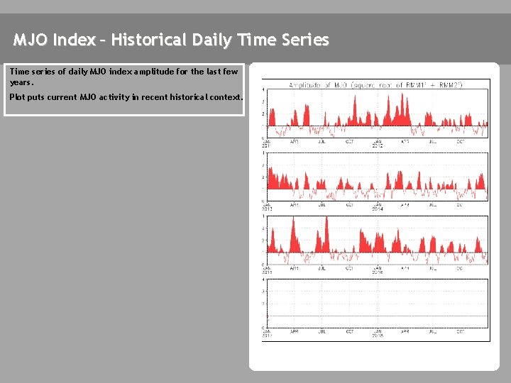
MJO Index – Historical Daily Time Series Time series of daily MJO index amplitude for the last few years. Plot puts current MJO activity in recent historical context.

GFS Ensemble (GEFS) MJO Forecast RMM 1 and RMM 2 values for the most recent 40 days and forecasts from the GFS ensemble system (GEFS) for the next 15 days light gray shading: 90% of forecasts dark gray shading: 50% of forecasts The GEFS forecast depicts a weak signal during Week-1. The signal strengthens across Africa and the western Indian Ocean during week-2. Yellow Lines – 20 Individual Members Green Line – Ensemble Mean

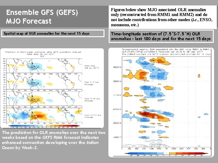
Ensemble GFS (GEFS) MJO Forecast Spatial map of OLR anomalies for the next 15 days The GEFS plot of MJO related OLR anomalies is unavailable at this time. The prediction for OLR anomalies over the next two weeks based on the GEFS RMM forecast indicates enhanced convection developing over the Indian Ocean by Week-2. Figures below show MJO associated OLR anomalies only (reconstructed from RMM 1 and RMM 2) and do not include contributions from other modes (i. e. , ENSO, monsoons, etc. ) Time-longitude section of (7. 5°S-7. 5°N) OLR anomalies - last 180 days and for the next 15 days The GEFS plot of MJO related OLR anomalies is unavailable at this time.

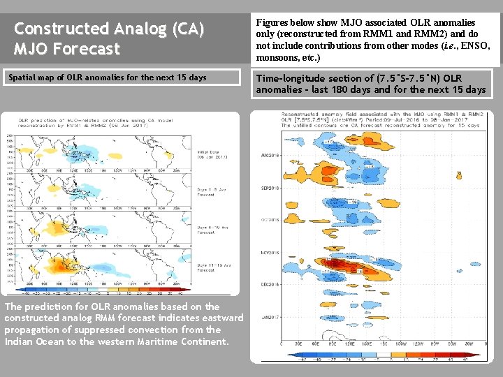
Constructed Analog (CA) MJO Forecast Figures below show MJO associated OLR anomalies only (reconstructed from RMM 1 and RMM 2) and do not include contributions from other modes (i. e. , ENSO, monsoons, etc. ) Spatial map of OLR anomalies for the next 15 days Time-longitude section of (7. 5°S-7. 5°N) OLR anomalies - last 180 days and for the next 15 days The prediction for OLR anomalies based on the constructed analog RMM forecast indicates eastward propagation of suppressed convection from the Indian Ocean to the western Maritime Continent.

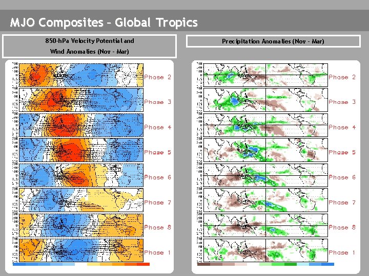
MJO Composites – Global Tropics 850 -h. Pa Velocity Potential and Wind Anomalies (Nov - Mar) Precipitation Anomalies (Nov - Mar)

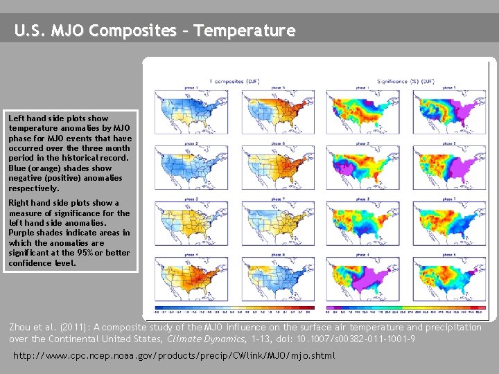
U. S. MJO Composites – Temperature Left hand side plots show temperature anomalies by MJO phase for MJO events that have occurred over the three month period in the historical record. Blue (orange) shades show negative (positive) anomalies respectively. Right hand side plots show a measure of significance for the left hand side anomalies. Purple shades indicate areas in which the anomalies are significant at the 95% or better confidence level. Zhou et al. (2011): A composite study of the MJO influence on the surface air temperature and precipitation over the Continental United States, Climate Dynamics, 1 -13, doi: 10. 1007/s 00382 -011 -1001 -9 http: //www. cpc. ncep. noaa. gov/products/precip/CWlink/MJO/mjo. shtml

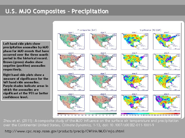
U. S. MJO Composites – Precipitation Left hand side plots show precipitation anomalies by MJO phase for MJO events that have occurred over the three month period in the historical record. Brown (green) shades show negative (positive) anomalies respectively. Right hand side plots show a measure of significance for the left hand side anomalies. Purple shades indicate areas in which the anomalies are significant at the 95% or better confidence level. Zhou et al. (2011): A composite study of the MJO influence on the surface air temperature and precipitation over the Continental United States, Climate Dynamics, 1 -13, doi: 10. 1007/s 00382 -011 -1001 -9 http: //www. cpc. ncep. noaa. gov/products/precip/CWlink/MJO/mjo. shtml