MaddenJulian Oscillation Recent Evolution Current Status and Predictions
- Slides: 14

Madden-Julian Oscillation: Recent Evolution, Current Status and Predictions Update prepared by the Climate Prediction Center / NCEP 25 November 2019

Overview The MJO remains active, though at low amplitude, with the enhanced phase centered over the Indian Ocean. Dynamical Model forecasts suggests the MJO is likely to remain weak during the early to mid portions of Week-1 with possible reemergence and eastward propagation over the Indian Ocean by Week-2. Tropical cyclogenesis remains likely over the Western Pacific in association with forecast equatorial Rossby wave activity and over the Indian Ocean tied to the presence of the enhanced phase of the MJO. A discussion of potential impacts for the global tropics and those related to the U. S. are updated on Tuesday at: http: //www. cpc. ncep. noaa. gov/products/precip/CWlink/ghazards/index. php

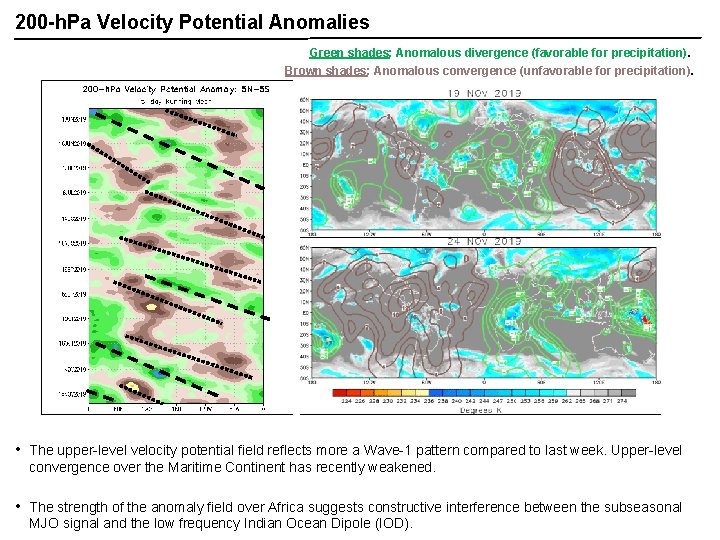
200 -h. Pa Velocity Potential Anomalies Green shades: Anomalous divergence (favorable for precipitation). Brown shades: Anomalous convergence (unfavorable for precipitation). • The upper-level velocity potential field reflects more a Wave-1 pattern compared to last week. Upper-level convergence over the Maritime Continent has recently weakened. • The strength of the anomaly field over Africa suggests constructive interference between the subseasonal MJO signal and the low frequency Indian Ocean Dipole (IOD).

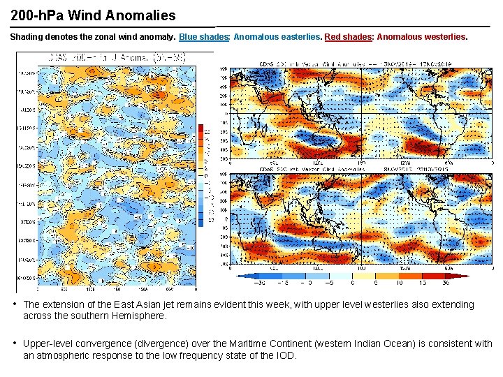
200 -h. Pa Wind Anomalies Shading denotes the zonal wind anomaly. Blue shades: Anomalous easterlies. Red shades: Anomalous westerlies. A A • The extension of the East Asian jet remains evident this week, with upper level westerlies also extending across the southern Hemisphere. • Upper-level convergence (divergence) over the Maritime Continent (western Indian Ocean) is consistent with an atmospheric response to the low frequency state of the IOD.

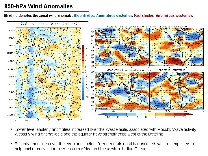
850 -h. Pa Wind Anomalies Shading denotes the zonal wind anomaly. Blue shades: Anomalous easterlies. Red shades: Anomalous westerlies. • Lower-level easterly anomalies increased over the West Pacific associated with Rossby Wave activity. Westerly wind anomalies along the equator have strengthened west of the Dateline. • Easterly anomalies over the equatorial Indian Ocean remain notably enhanced, which is expected to help anchor convection over eastern Africa and the western Indian Ocean.

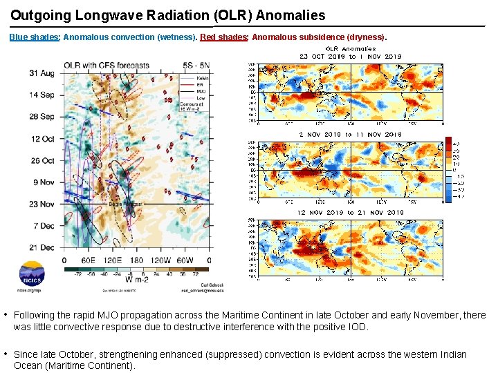
Outgoing Longwave Radiation (OLR) Anomalies Blue shades: Anomalous convection (wetness). Red shades: Anomalous subsidence (dryness). • Following the rapid MJO propagation across the Maritime Continent in late October and early November, there was little convective response due to destructive interference with the positive IOD. • Since late October, strengthening enhanced (suppressed) convection is evident across the western Indian Ocean (Maritime Continent).

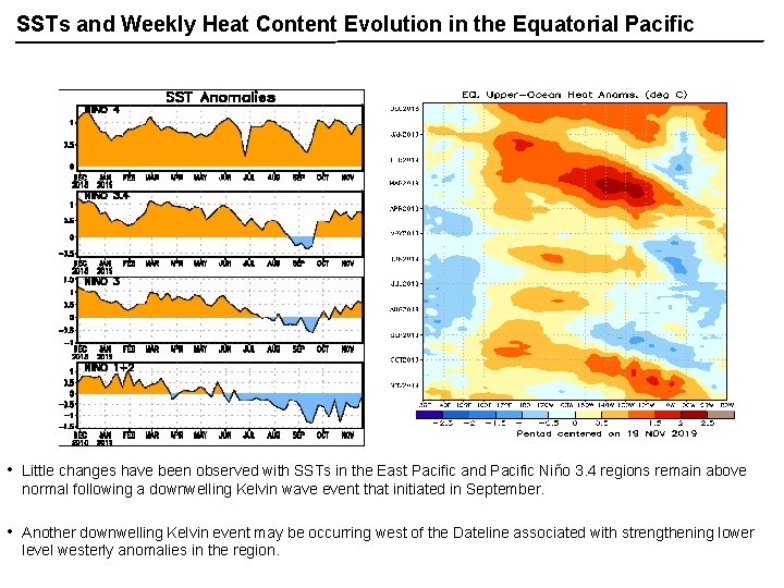
SSTs and Weekly Heat Content Evolution in the Equatorial Pacific • Little changes have been observed with SSTs in the East Pacific and Pacific Niño 3. 4 regions remain above normal following a downwelling Kelvin wave event that initiated in September. • Another downwelling Kelvin event may be occurring west of the Dateline associated with strengthening lower level westerly anomalies in the region.

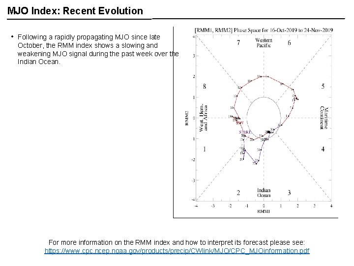
MJO Index: Recent Evolution • Following a rapidly propagating MJO since late October, the RMM index shows a slowing and weakening MJO signal during the past week over the Indian Ocean. For more information on the RMM index and how to interpret its forecast please see: https: //www. cpc. ncep. noaa. gov/products/precip/CWlink/MJO/CPC_MJOinformation. pdf

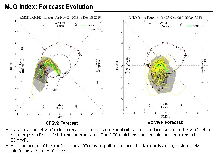
MJO Index: Forecast Evolution CFSv 2 Forecast • • ECMWF Forecast Dynamical model MJO index forecasts are in fair agreement with a continued weakening of the MJO before re-emerging in Phase-8/1 during the next week. The CFS maintains a faster solution compared to the ECMWF. A strengthening of the low frequency IOD may be pulling the index back towards Africa, destructively interfering with the MJO signal.

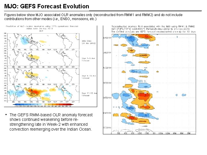
MJO: GEFS Forecast Evolution Figures below show MJO associated OLR anomalies only (reconstructed from RMM 1 and RMM 2) and do not include contributions from other modes (i. e. , ENSO, monsoons, etc. ) • The GEFS RMM-based OLR anomaly forecast shows continued weakening before restrengthening late in Week-2 with enhanced convection reemerging over the Indian Ocean.

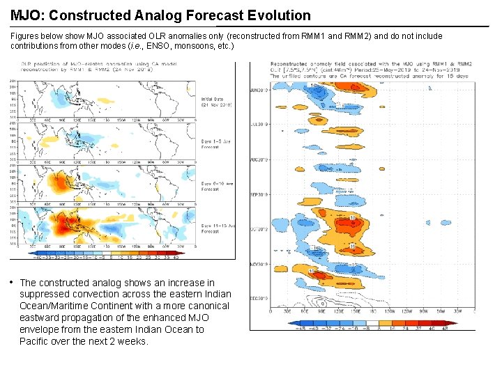
MJO: Constructed Analog Forecast Evolution Figures below show MJO associated OLR anomalies only (reconstructed from RMM 1 and RMM 2) and do not include contributions from other modes (i. e. , ENSO, monsoons, etc. ) • The constructed analog shows an increase in suppressed convection across the eastern Indian Ocean/Maritime Continent with a more canonical eastward propagation of the enhanced MJO envelope from the eastern Indian Ocean to Pacific over the next 2 weeks.

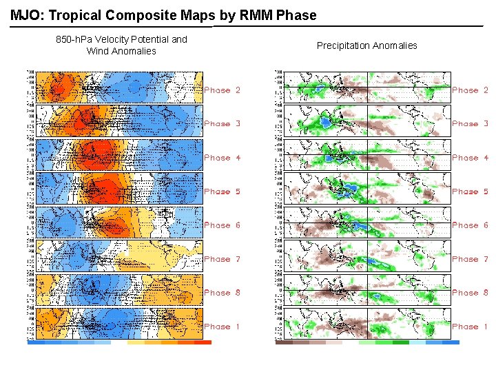
MJO: Tropical Composite Maps by RMM Phase 850 -h. Pa Velocity Potential and Wind Anomalies Precipitation Anomalies

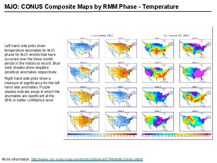
MJO: CONUS Composite Maps by RMM Phase - Temperature Left hand side plots show temperature anomalies by MJO phase for MJO events that have occurred over the three month period in the historical record. Blue (red) shades show negative (positive) anomalies respectively. Right hand side plots show a measure of significance for the left hand side anomalies. Purple shades indicate areas in which the anomalies are significant at the 95% or better confidence level. More information: http: //www. cpc. ncep. noaa. gov/products/precip/CWlink/MJO/mjo. shtml

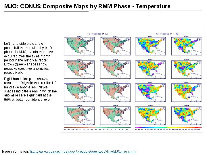
MJO: CONUS Composite Maps by RMM Phase - Temperature Left hand side plots show precipitation anomalies by MJO phase for MJO events that have occurred over the three month period in the historical record. Brown (green) shades show negative (positive) anomalies respectively. Right hand side plots show a measure of significance for the left hand side anomalies. Purple shades indicate areas in which the anomalies are significant at the 95% or better confidence level. More information: http: //www. cpc. ncep. noaa. gov/products/precip/CWlink/MJO/mjo. shtml