MaddenJulian Oscillation Recent Evolution Current Status and Predictions
- Slides: 21

Madden-Julian Oscillation: Recent Evolution, Current Status and Predictions Update prepared by: Climate Prediction Center / NCEP 5 March 2018

Outline Overview Recent Evolution and Current Conditions MJO Index Information MJO Index Forecasts MJO Composites

Overview The MJO continued across the Indian Ocean during the past week while showing signs of weakening. The signal appears most tied to anomalous upper-level divergence and to a lesser extent upper-level zonal winds and low-level anomalous westerlies. Tropical Cyclone Dumazile in the southern Indian Ocean may be partially responsible for the apparent character of the aforementioned wind fields by enhancing upper-level divergence and convection over the Indian Ocean but encouraging low-level easterlies near the equator. Low-level easterlies over the Pacific have also been relatively weak. Dynamical models continue to propagate the intraseasonal signal eastward during the next two weeks but at reduced amplitude, suggesting a possible return to a weak MJO state after active conditions during the past 3+ months. Additional potential impacts across the global tropics and a discussion for the U. S. are available at: http: //www. cpc. ncep. noaa. gov/products/precip/CWlink/ghazards/index. php

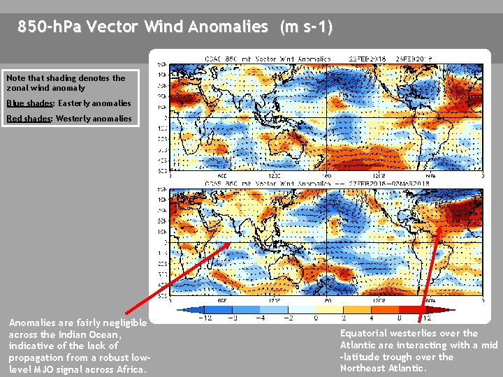
850 -h. Pa Vector Wind Anomalies (m s-1) Note that shading denotes the zonal wind anomaly Blue shades: Easterly anomalies Red shades: Westerly anomalies Anomalies are fairly negligible across the Indian Ocean, indicative of the lack of propagation from a robust lowlevel MJO signal across Africa. Equatorial westerlies over the Atlantic are interacting with a mid -latitude trough over the Northeast Atlantic.

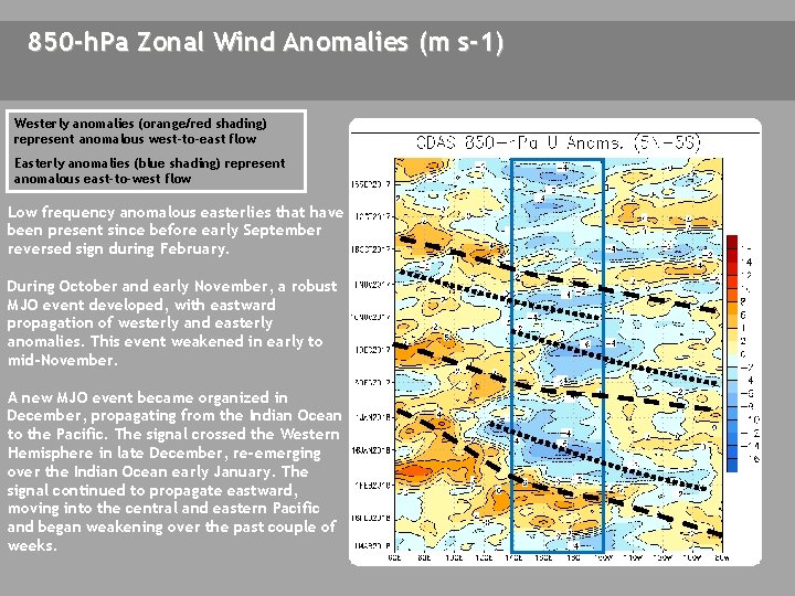
850 -h. Pa Zonal Wind Anomalies (m s-1) Westerly anomalies (orange/red shading) represent anomalous west-to-east flow Easterly anomalies (blue shading) represent anomalous east-to-west flow Low frequency anomalous easterlies that have been present since before early September reversed sign during February. During October and early November, a robust MJO event developed, with eastward propagation of westerly and easterly anomalies. This event weakened in early to mid-November. A new MJO event became organized in December, propagating from the Indian Ocean to the Pacific. The signal crossed the Western Hemisphere in late December, re-emerging over the Indian Ocean early January. The signal continued to propagate eastward, moving into the central and eastern Pacific and began weakening over the past couple of weeks.

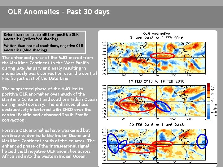
OLR Anomalies – Past 30 days Drier-than-normal conditions, positive OLR anomalies (yellow/red shading) Wetter-than-normal conditions, negative OLR anomalies (blue shading) The enhanced phase of the MJO moved from the Maritime Continent to the West Pacific during late January and early resulting in anomalously weak convection over the central Pacific just east of the Date Line. The suppressed phase of the MJO led to positive OLR anomalies over much of the Maritime Continent and southern Indian Ocean during mid-February. The enhanced phase destructively interfered with ENSO over the central Pacific and enhanced South Pacific convection. Positive OLR anomalies have weakened but continue to dominate the Indian Ocean and Maritime Continent south of the equator. The enhanced phase of the intraseasonal signal helped yield negative OLR anomalies across Africa and into the western Indian Ocean.

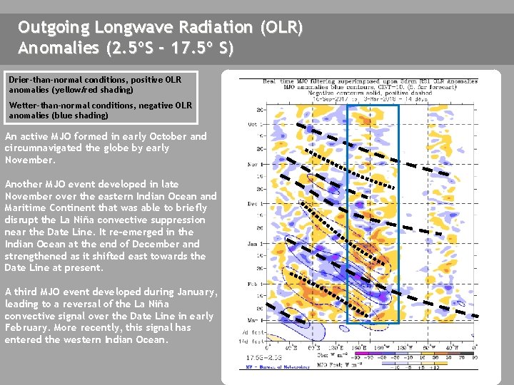
Outgoing Longwave Radiation (OLR) Anomalies (2. 5ºS - 17. 5º S) Drier-than-normal conditions, positive OLR anomalies (yellow/red shading) Wetter-than-normal conditions, negative OLR anomalies (blue shading) An active MJO formed in early October and circumnavigated the globe by early November. Another MJO event developed in late November over the eastern Indian Ocean and Maritime Continent that was able to briefly disrupt the La Niña convective suppression near the Date Line. It re-emerged in the Indian Ocean at the end of December and strengthened as it shifted east towards the Date Line at present. A third MJO event developed during January, leading to a reversal of the La Niña convective signal over the Date Line in early February. More recently, this signal has entered the western Indian Ocean.

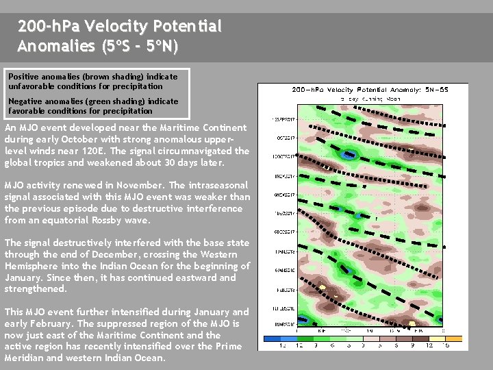
200 -h. Pa Velocity Potential Anomalies (5ºS - 5ºN) Positive anomalies (brown shading) indicate unfavorable conditions for precipitation Negative anomalies (green shading) indicate favorable conditions for precipitation An MJO event developed near the Maritime Continent during early October with strong anomalous upperlevel winds near 120 E. The signal circumnavigated the global tropics and weakened about 30 days later. MJO activity renewed in November. The intraseasonal signal associated with this MJO event was weaker than the previous episode due to destructive interference from an equatorial Rossby wave. The signal destructively interfered with the base state through the end of December, crossing the Western Hemisphere into the Indian Ocean for the beginning of January. Since then, it has continued eastward and strengthened. This MJO event further intensified during January and early February. The suppressed region of the MJO is now just east of the Maritime Continent and the active region has recently intensified over the Prime Meridian and western Indian Ocean.

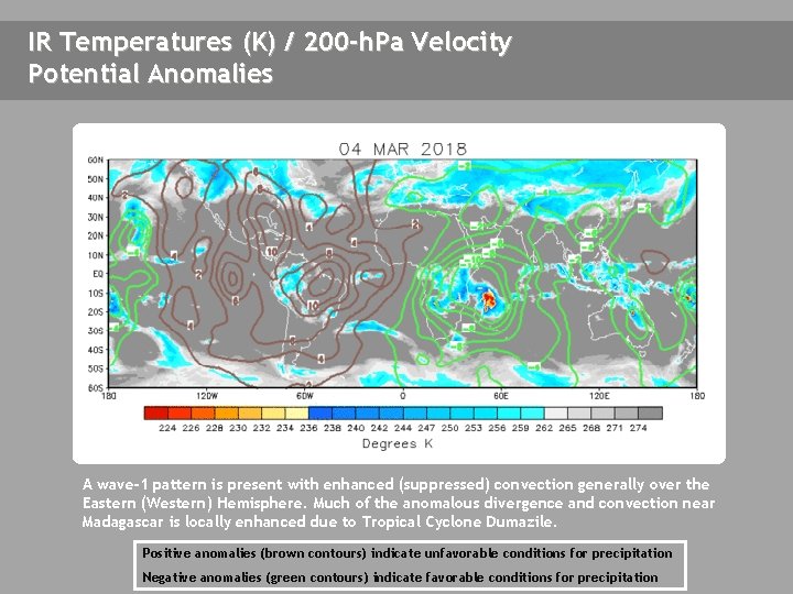
IR Temperatures (K) / 200 -h. Pa Velocity Potential Anomalies THIS SLIDE NOT UPDATED A wave-1 pattern is present with enhanced (suppressed) convection generally over the Eastern (Western) Hemisphere. Much of the anomalous divergence and convection near Madagascar is locally enhanced due to Tropical Cyclone Dumazile. Positive anomalies (brown contours) indicate unfavorable conditions for precipitation Negative anomalies (green contours) indicate favorable conditions for precipitation

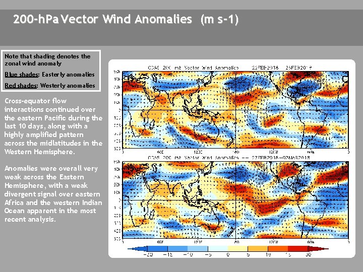
200 -h. Pa Vector Wind Anomalies (m s-1) Note that shading denotes the zonal wind anomaly Blue shades: Easterly anomalies Red shades: Westerly anomalies Cross-equator flow interactions continued over the eastern Pacific during the last 10 days, along with a highly amplified pattern across the midlatitudes in the Western Hemisphere. Anomalies were overall very weak across the Eastern Hemisphere, with a weak divergent signal over eastern Africa and the western Indian Ocean apparent in the most recent analysis. T D R C

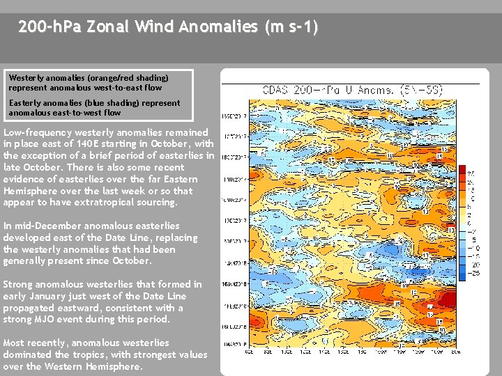
200 -h. Pa Zonal Wind Anomalies (m s-1) Westerly anomalies (orange/red shading) represent anomalous west-to-east flow Easterly anomalies (blue shading) represent anomalous east-to-west flow Low-frequency westerly anomalies remained in place east of 140 E starting in October, with the exception of a brief period of easterlies in late October. There is also some recent evidence of easterlies over the far Eastern Hemisphere over the last week or so that appear to have extratropical sourcing. In mid-December anomalous easterlies developed east of the Date Line, replacing the westerly anomalies that had been generally present since October. Strong anomalous westerlies that formed in early January just west of the Date Line propagated eastward, consistent with a strong MJO event during this period. Most recently, anomalous westerlies dominated the tropics, with strongest values over the Western Hemisphere.

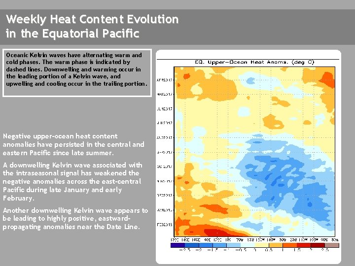
Weekly Heat Content Evolution in the Equatorial Pacific Oceanic Kelvin waves have alternating warm and cold phases. The warm phase is indicated by dashed lines. Downwelling and warming occur in the leading portion of a Kelvin wave, and upwelling and cooling occur in the trailing portion. Negative upper-ocean heat content anomalies have persisted in the central and eastern Pacific since late summer. A downwelling Kelvin wave associated with the intraseasonal signal has weakened the negative anomalies across the east-central Pacific during late January and early February. Another downwelling Kelvin wave appears to be leading to highly positive, eastwardpropagating anomalies near the Date Line.

MJO Index -- Information The MJO index illustrated on the next several slides is the CPC version of the Wheeler and Hendon index (2004, hereafter WH 2004). Wheeler M. and H. Hendon, 2004: An All-Season Real-Time Multivariate MJO Index: Development of an Index for Monitoring and Prediction, Monthly Weather Review, 132, 1917 -1932. The methodology is very similar to that described in WH 2004 but does not include the linear removal of ENSO variability associated with a sea surface temperature index. The methodology is consistent with that outlined by the U. S. CLIVAR MJO Working Group. Gottschalck et al. 2010: A Framework for Assessing Operational Madden-Julian Oscillation Forecasts: A CLIVAR MJO Working Group Project, Bull. Amer. Met. Soc. , 91, 1247 -1258. The index is based on a combined Empirical Orthogonal Function (EOF) analysis using fields of near-equatorially-averaged 850 -h. Pa and 200 -h. Pa zonal wind and outgoing longwave radiation (OLR).

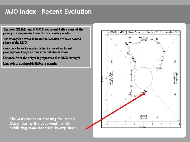
MJO Index – Recent Evolution The axes (RMM 1 and RMM 2) represent daily values of the principal components from the two leading modes The triangular areas indicate the location of the enhanced phase of the MJO Counter-clockwise motion is indicative of eastward propagation. Large dot most recent observation. Distance from the origin is proportional to MJO strength Line colors distinguish different months The MJO has been crossing the Indian Ocean during the past week, while exhibiting some decrease in amplitude.

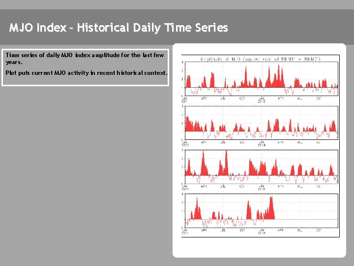
MJO Index – Historical Daily Time Series Time series of daily MJO index amplitude for the last few years. Plot puts current MJO activity in recent historical context.

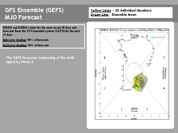
GFS Ensemble (GEFS) MJO Forecast RMM 1 and RMM 2 values for the most recent 40 days and forecasts from the GFS ensemble system (GEFS) for the next 15 days light gray shading: 90% of forecasts dark gray shading: 50% of forecasts The GEFS forecasts weakening of the MJO signal by Week-2. Yellow Lines – 20 Individual Members Green Line – Ensemble Mean

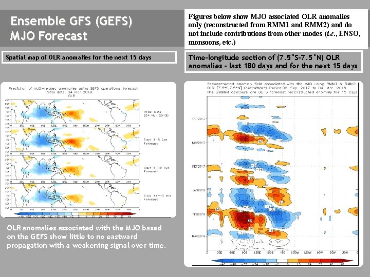
Ensemble GFS (GEFS) MJO Forecast Spatial map of OLR anomalies for the next 15 days The GEFS plot of MJO related OLR anomalies is unavailable at this time. OLR anomalies associated with the MJO based on the GEFS show little to no eastward propagation with a weakening signal over time. Figures below show MJO associated OLR anomalies only (reconstructed from RMM 1 and RMM 2) and do not include contributions from other modes (i. e. , ENSO, monsoons, etc. ) Time-longitude section of (7. 5°S-7. 5°N) OLR anomalies - last 180 days and for the next 15 days The GEFS plot of MJO related OLR anomalies is unavailable at this time.

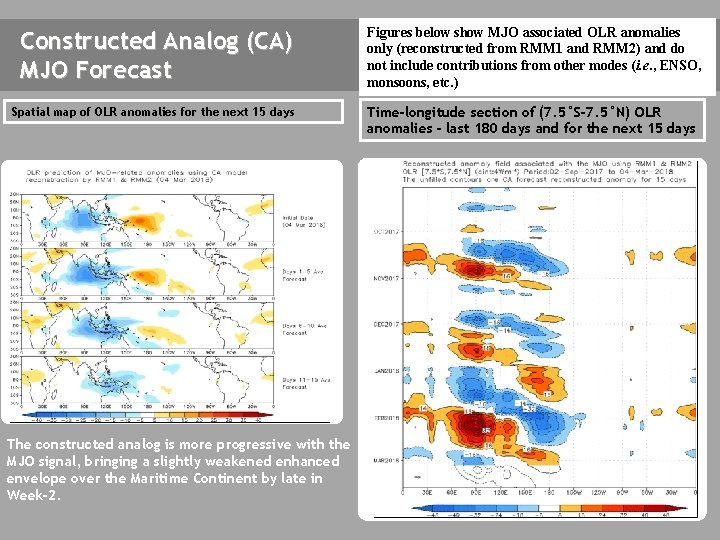
Constructed Analog (CA) MJO Forecast Spatial map of OLR anomalies for the next 15 days Figures below show MJO associated OLR anomalies only (reconstructed from RMM 1 and RMM 2) and do not include contributions from other modes (i. e. , ENSO, monsoons, etc. ) Time-longitude section of (7. 5°S-7. 5°N) OLR anomalies - last 180 days and for the next 15 days The GEFS plot of MJO related OLR anomalies is unavailable at this time. The constructed analog is more progressive with the MJO signal, bringing a slightly weakened enhanced envelope over the Maritime Continent by late in Week-2.

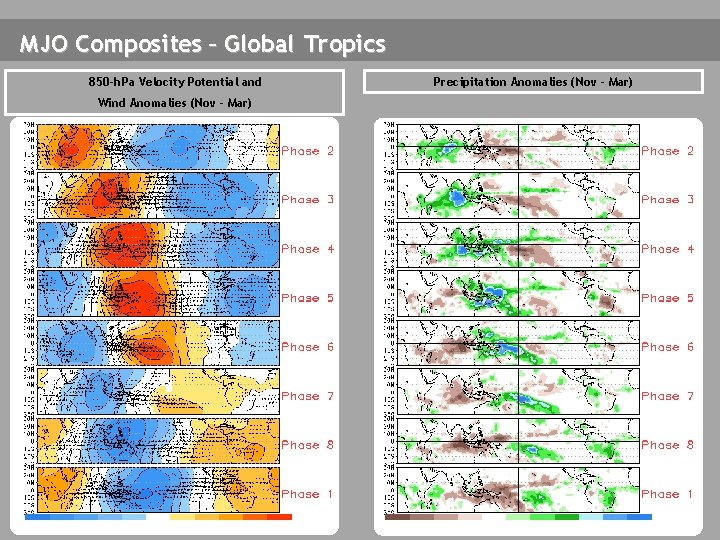
MJO Composites – Global Tropics 850 -h. Pa Velocity Potential and Wind Anomalies (Nov - Mar) Precipitation Anomalies (Nov - Mar)

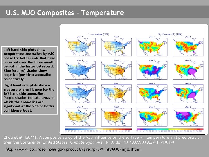
U. S. MJO Composites – Temperature Left hand side plots show temperature anomalies by MJO phase for MJO events that have occurred over the three month period in the historical record. Blue (orange) shades show negative (positive) anomalies respectively. Right hand side plots show a measure of significance for the left hand side anomalies. Purple shades indicate areas in which the anomalies are significant at the 95% or better confidence level. Zhou et al. (2011): A composite study of the MJO influence on the surface air temperature and precipitation over the Continental United States, Climate Dynamics, 1 -13, doi: 10. 1007/s 00382 -011 -1001 -9 http: //www. cpc. ncep. noaa. gov/products/precip/CWlink/MJO/mjo. shtml

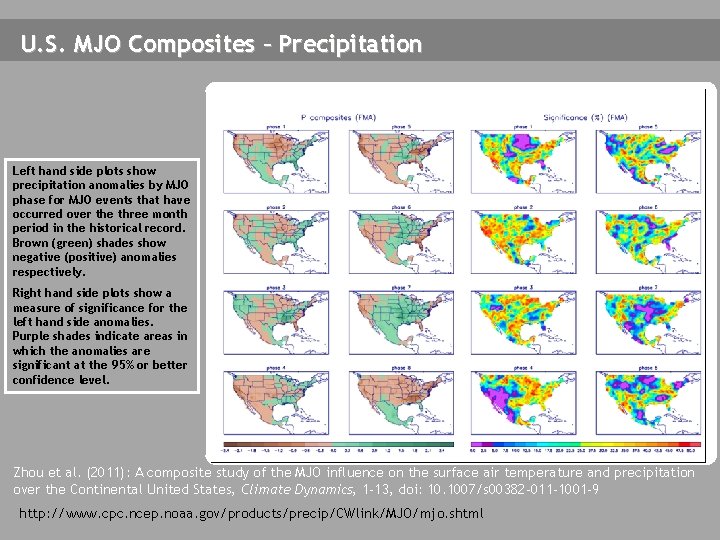
U. S. MJO Composites – Precipitation Left hand side plots show precipitation anomalies by MJO phase for MJO events that have occurred over the three month period in the historical record. Brown (green) shades show negative (positive) anomalies respectively. Right hand side plots show a measure of significance for the left hand side anomalies. Purple shades indicate areas in which the anomalies are significant at the 95% or better confidence level. Zhou et al. (2011): A composite study of the MJO influence on the surface air temperature and precipitation over the Continental United States, Climate Dynamics, 1 -13, doi: 10. 1007/s 00382 -011 -1001 -9 http: //www. cpc. ncep. noaa. gov/products/precip/CWlink/MJO/mjo. shtml