MaddenJulian Oscillation Recent Evolution Current Status and Predictions
- Slides: 14

Madden-Julian Oscillation: Recent Evolution, Current Status and Predictions Update prepared by the Climate Prediction Center / NCEP 30 September 2019

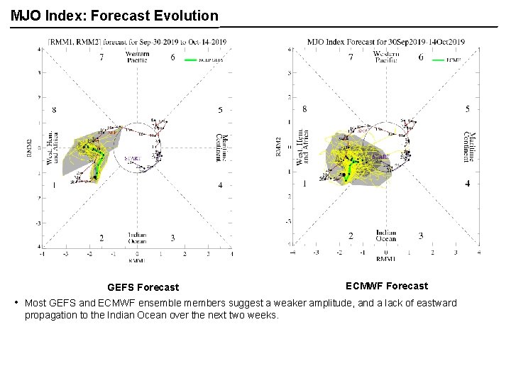
Overview The MJO has been present primarily in the upper-level velocity potential field during much of September but has weakened over the past few days. Dynamical and statistical model guidance show no evidence of eastward propagation of the MJO signal during Week-1, with some potential for re-emergence during Week-2. While RMM analyses support the MJO being active over the Western Hemisphere, caution has to be exhibited as the developing positive phase of the Indian Ocean Dipole event across the Eastern Hemisphere appears to be erroneously projecting onto the MJO being in Phase-1 due to the robust easterlies across the Indian Ocean. If an active MJO is present, it is at least likely being overdone given the low frequency state in the Eastern Hemisphere. A discussion of potential impacts for the global tropics and those related to the U. S. are updated on Tuesday at: http: //www. cpc. ncep. noaa. gov/products/precip/CWlink/ghazards/index. php

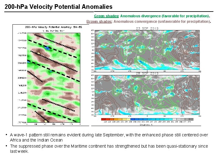
200 -h. Pa Velocity Potential Anomalies Green shades: Anomalous divergence (favorable for precipitation). Brown shades: Anomalous convergence (unfavorable for precipitation). • • A wave-1 pattern still remains evident during late September, with the enhanced phase still centered over Africa and the Indian Ocean The suppressed phase over the Maritime continent has strengthened but has been quasi-stationary since last week.

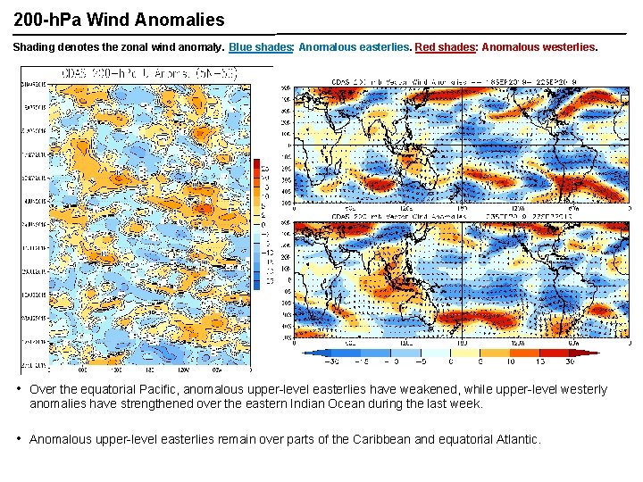
200 -h. Pa Wind Anomalies Shading denotes the zonal wind anomaly. Blue shades: Anomalous easterlies. Red shades: Anomalous westerlies. A A • Over the equatorial Pacific, anomalous upper-level easterlies have weakened, while upper-level westerly anomalies have strengthened over the eastern Indian Ocean during the last week. • Anomalous upper-level easterlies remain over parts of the Caribbean and equatorial Atlantic.

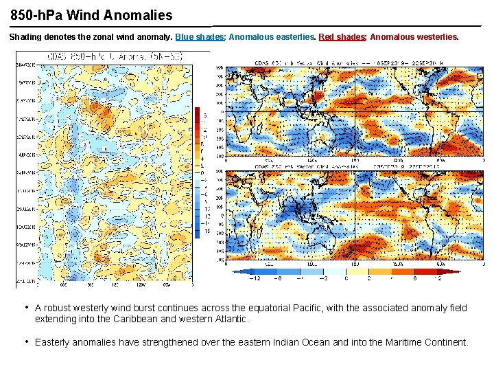
850 -h. Pa Wind Anomalies Shading denotes the zonal wind anomaly. Blue shades: Anomalous easterlies. Red shades: Anomalous westerlies. • A robust westerly wind burst continues across the equatorial Pacific, with the associated anomaly field extending into the Caribbean and western Atlantic. • Easterly anomalies have strengthened over the eastern Indian Ocean and into the Maritime Continent.

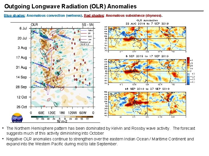
Outgoing Longwave Radiation (OLR) Anomalies Blue shades: Anomalous convection (wetness). Red shades: Anomalous subsidence (dryness). • • The Northern Hemisphere pattern has been dominated by Kelvin and Rossby wave activity. The forecast suggests much of this activity diminishing into October Negative OLR anomalies continue to strengthen over the eastern Indian Ocean / Maritime Continent and expand into the Western Pacific during mid to late September.

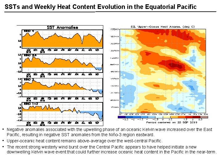
SSTs and Weekly Heat Content Evolution in the Equatorial Pacific • • • Negative anomalies associated with the upwelling phase of an oceanic Kelvin wave increased over the East Pacific, resulting in negative SST anomalies from the Niño-3 region eastward. Upper-oceanic heat content remains above-average over the west-central Pacific. The recent strong westerly wind burst over the Central Pacific appears to have helped initiate a new downwelling Kelvin wave event that could further increase oceanic heat content in the Pacific in the near-term.

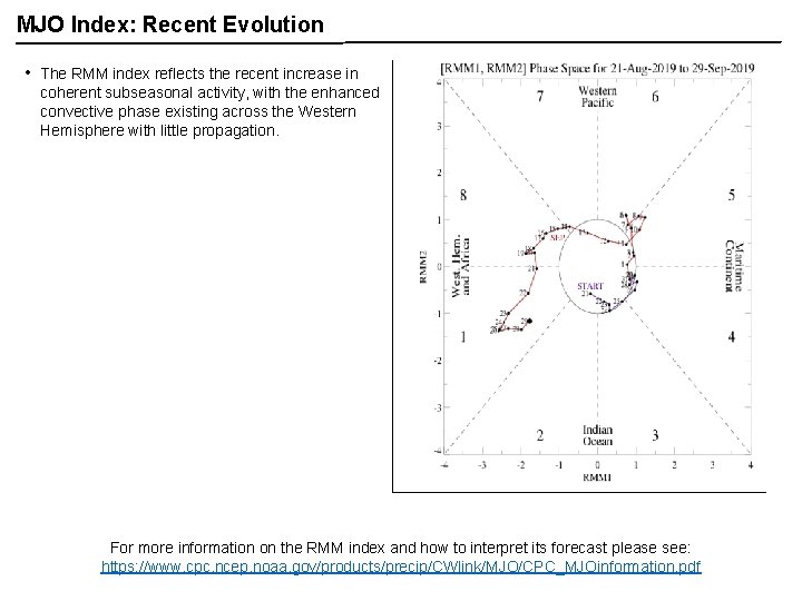
MJO Index: Recent Evolution • The RMM index reflects the recent increase in coherent subseasonal activity, with the enhanced convective phase existing across the Western Hemisphere with little propagation. For more information on the RMM index and how to interpret its forecast please see: https: //www. cpc. ncep. noaa. gov/products/precip/CWlink/MJO/CPC_MJOinformation. pdf

MJO Index: Forecast Evolution GEFS Forecast • ECMWF Forecast Most GEFS and ECMWF ensemble members suggest a weaker amplitude, and a lack of eastward propagation to the Indian Ocean over the next two weeks.

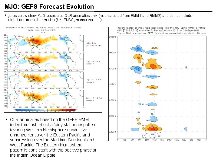
MJO: GEFS Forecast Evolution Figures below show MJO associated OLR anomalies only (reconstructed from RMM 1 and RMM 2) and do not include contributions from other modes (i. e. , ENSO, monsoons, etc. ) • OLR anomalies based on the GEFS RMM index forecast reflect a fairly stationary pattern favoring Western Hemisphere convective enhancement over the Eastern Pacific and suppression over the Maritime Continent and West Pacific. The Eastern Hemisphere pattern is consistent with the positive phase of the Indian Ocean Dipole.

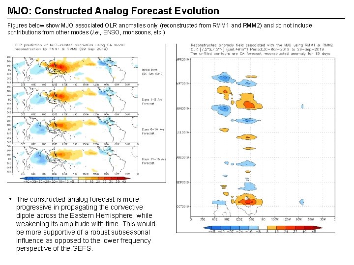
MJO: Constructed Analog Forecast Evolution Figures below show MJO associated OLR anomalies only (reconstructed from RMM 1 and RMM 2) and do not include contributions from other modes (i. e. , ENSO, monsoons, etc. ) • The constructed analog forecast is more progressive in propagating the convective dipole across the Eastern Hemisphere, while weakening its amplitude with time. This would be more supportive of a robust subseasonal influence as opposed to the lower frequency perspective of the GEFS.

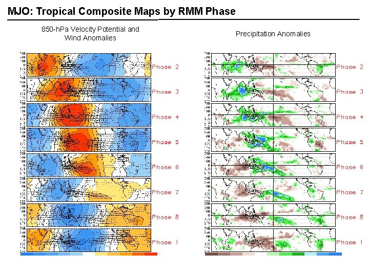
MJO: Tropical Composite Maps by RMM Phase 850 -h. Pa Velocity Potential and Wind Anomalies Precipitation Anomalies

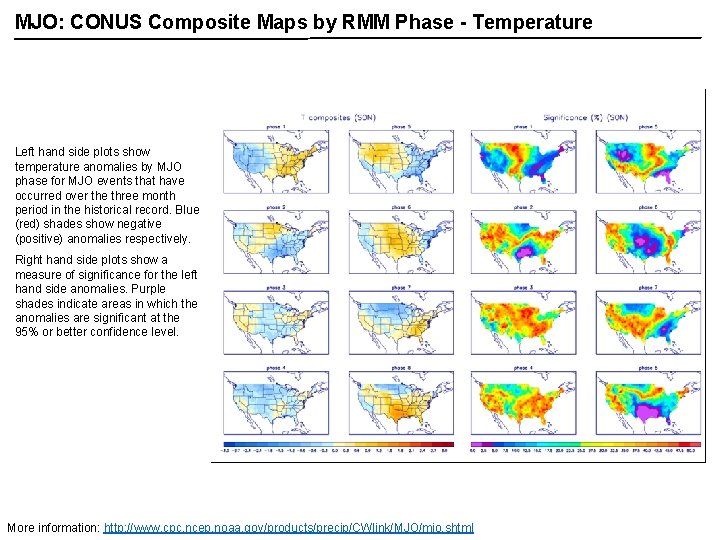
MJO: CONUS Composite Maps by RMM Phase - Temperature Left hand side plots show temperature anomalies by MJO phase for MJO events that have occurred over the three month period in the historical record. Blue (red) shades show negative (positive) anomalies respectively. Right hand side plots show a measure of significance for the left hand side anomalies. Purple shades indicate areas in which the anomalies are significant at the 95% or better confidence level. More information: http: //www. cpc. ncep. noaa. gov/products/precip/CWlink/MJO/mjo. shtml

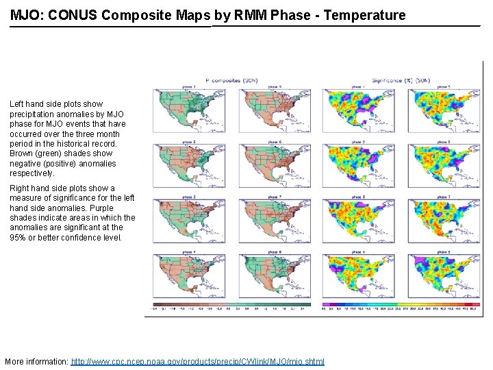
MJO: CONUS Composite Maps by RMM Phase - Temperature Left hand side plots show precipitation anomalies by MJO phase for MJO events that have occurred over the three month period in the historical record. Brown (green) shades show negative (positive) anomalies respectively. Right hand side plots show a measure of significance for the left hand side anomalies. Purple shades indicate areas in which the anomalies are significant at the 95% or better confidence level. More information: http: //www. cpc. ncep. noaa. gov/products/precip/CWlink/MJO/mjo. shtml