MaddenJulian Oscillation Recent Evolution Current Status and Predictions
- Slides: 14

Madden-Julian Oscillation: Recent Evolution, Current Status and Predictions Update prepared by the Climate Prediction Center / NCEP 15 April 2019

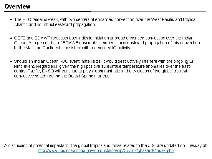
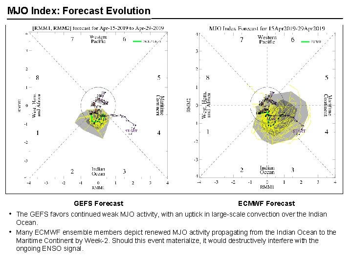
Overview The MJO remains weak, with two centers of enhanced convection over the West Pacific and tropical Atlantic and no robust eastward propagation. GEFS and ECMWF forecasts both indicate initiation of broad enhanced convection over the Indian Ocean. A large number of ECMWF ensemble members show eastward propagation of this convection to the Maritime Continent, consistent with renewed MJO activity. Should an Indian Ocean MJO event materialize, it would destructively interfere with the ongoing El Niño event. Regardless, given the high positive subsurface temperature anomalies over the eastcentral Pacific, ENSO will continue to play a dominant role in the evolution of the global tropical convective pattern during the Boreal Spring months. A discussion of potential impacts for the global tropics and those related to the U. S. are updated on Tuesday at: http: //www. cpc. ncep. noaa. gov/products/precip/CWlink/ghazards/index. php

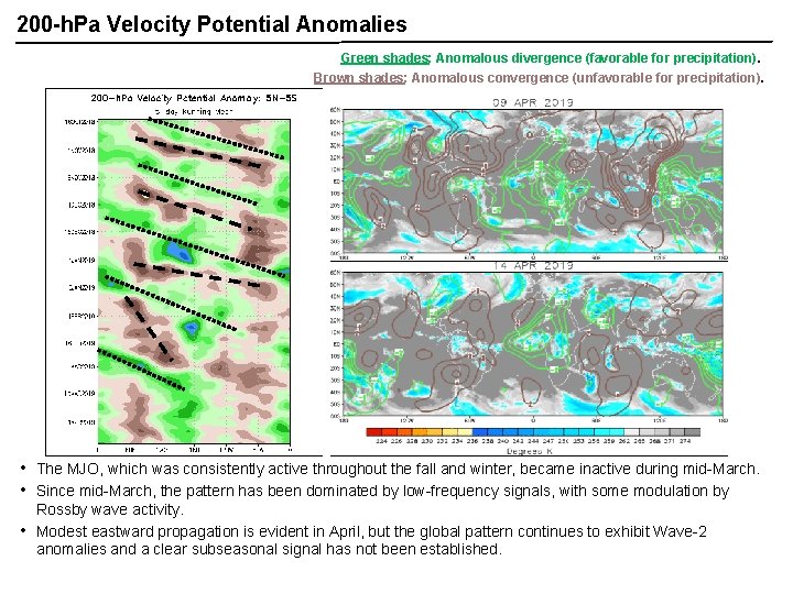
200 -h. Pa Velocity Potential Anomalies Green shades: Anomalous divergence (favorable for precipitation). Brown shades: Anomalous convergence (unfavorable for precipitation). • • • The MJO, which was consistently active throughout the fall and winter, became inactive during mid-March. Since mid-March, the pattern has been dominated by low-frequency signals, with some modulation by Rossby wave activity. Modest eastward propagation is evident in April, but the global pattern continues to exhibit Wave-2 anomalies and a clear subseasonal signal has not been established.

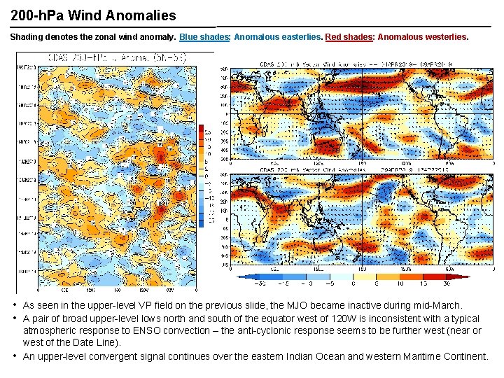
200 -h. Pa Wind Anomalies Shading denotes the zonal wind anomaly. Blue shades: Anomalous easterlies. Red shades: Anomalous westerlies. • • • As seen in the upper-level VP field on the previous slide, the MJO became inactive during mid-March. A pair of broad upper-level lows north and south of the equator west of 120 W is inconsistent with a typical atmospheric response to ENSO convection – the anti-cyclonic response seems to be further west (near or west of the Date Line). An upper-level convergent signal continues over the eastern Indian Ocean and western Maritime Continent.

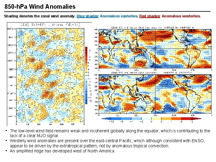
850 -h. Pa Wind Anomalies Shading denotes the zonal wind anomaly. Blue shades: Anomalous easterlies. Red shades: Anomalous westerlies. • • • The low-level wind field remains weak and incoherent globally along the equator, which is contributing to the lack of a clear MJO signal. Westerly wind anomalies are present over the east-central Pacific, which although consistent with ENSO, appear to be driven by the extratropical pattern, not by anomalous tropical convection. An amplified ridge has developed west of North America.

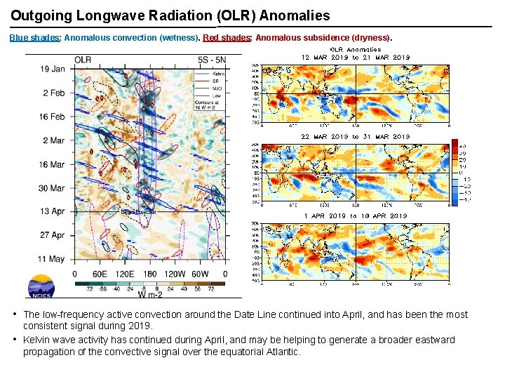
Outgoing Longwave Radiation (OLR) Anomalies Blue shades: Anomalous convection (wetness). Red shades: Anomalous subsidence (dryness). • • The low-frequency active convection around the Date Line continued into April, and has been the most consistent signal during 2019. Kelvin wave activity has continued during April, and may be helping to generate a broader eastward propagation of the convective signal over the equatorial Atlantic.

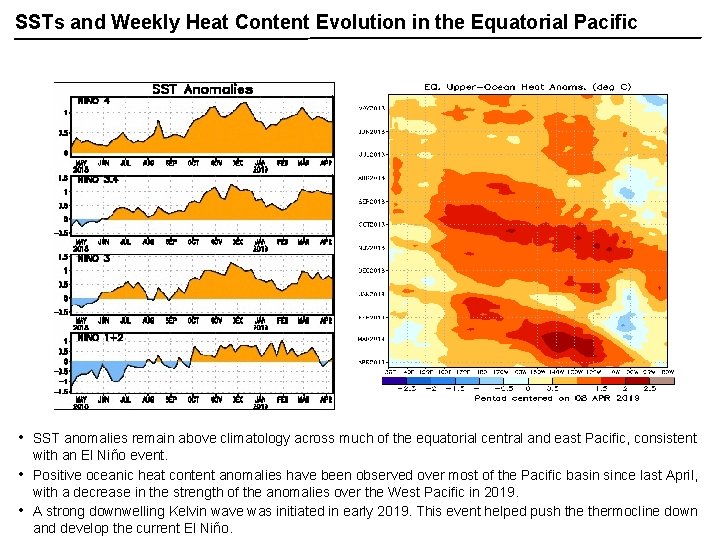
SSTs and Weekly Heat Content Evolution in the Equatorial Pacific • • • SST anomalies remain above climatology across much of the equatorial central and east Pacific, consistent with an El Niño event. Positive oceanic heat content anomalies have been observed over most of the Pacific basin since last April, with a decrease in the strength of the anomalies over the West Pacific in 2019. A strong downwelling Kelvin wave was initiated in early 2019. This event helped push thermocline down and develop the current El Niño.

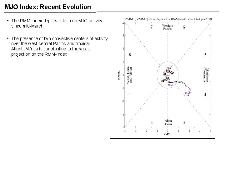
MJO Index: Recent Evolution • The RMM index depicts little to no MJO activity since mid-March. • The presence of two convective centers of activity over the west-central Pacific and tropical Atlantic/Africa is contributing to the weak projection on the RMM-index.

MJO Index: Forecast Evolution GEFS Forecast • • ECMWF Forecast The GEFS favors continued weak MJO activity, with an uptick in large-scale convection over the Indian Ocean. Many ECMWF ensemble members depict renewed MJO activity propagating from the Indian Ocean to the Maritime Continent by Week-2. Should this event materialize, it would destructively interfere with the ongoing ENSO signal.

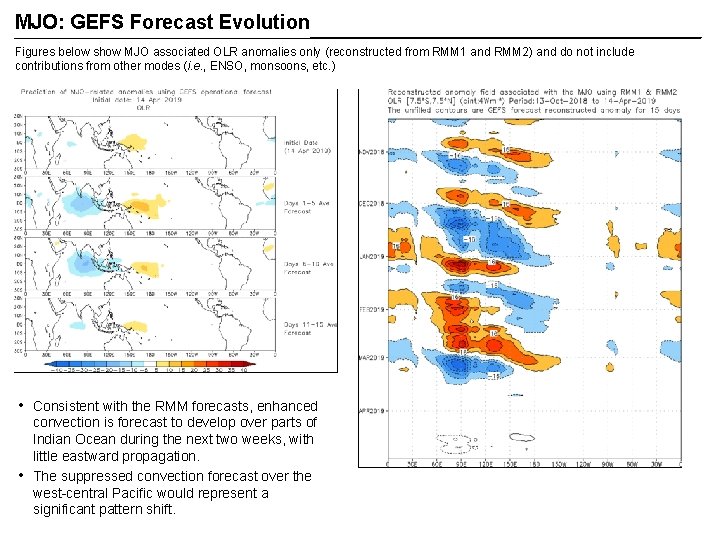
MJO: GEFS Forecast Evolution Figures below show MJO associated OLR anomalies only (reconstructed from RMM 1 and RMM 2) and do not include contributions from other modes (i. e. , ENSO, monsoons, etc. ) • • Consistent with the RMM forecasts, enhanced convection is forecast to develop over parts of Indian Ocean during the next two weeks, with little eastward propagation. The suppressed convection forecast over the west-central Pacific would represent a significant pattern shift.

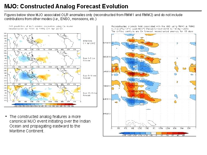
MJO: Constructed Analog Forecast Evolution Figures below show MJO associated OLR anomalies only (reconstructed from RMM 1 and RMM 2) and do not include contributions from other modes (i. e. , ENSO, monsoons, etc. ) • The constructed analog features a more canonical MJO event initiating over the Indian Ocean and propagating eastward to the Maritime Continent.

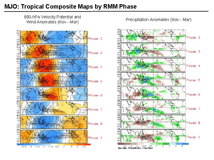
MJO: Tropical Composite Maps by RMM Phase 850 -h. Pa Velocity Potential and Wind Anomalies (Nov - Mar) Precipitation Anomalies (Nov - Mar)

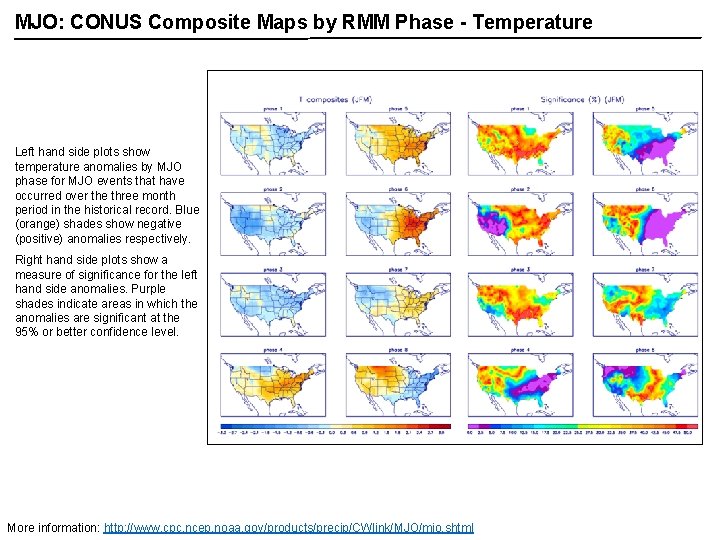
MJO: CONUS Composite Maps by RMM Phase - Temperature Left hand side plots show temperature anomalies by MJO phase for MJO events that have occurred over the three month period in the historical record. Blue (orange) shades show negative (positive) anomalies respectively. Right hand side plots show a measure of significance for the left hand side anomalies. Purple shades indicate areas in which the anomalies are significant at the 95% or better confidence level. More information: http: //www. cpc. ncep. noaa. gov/products/precip/CWlink/MJO/mjo. shtml

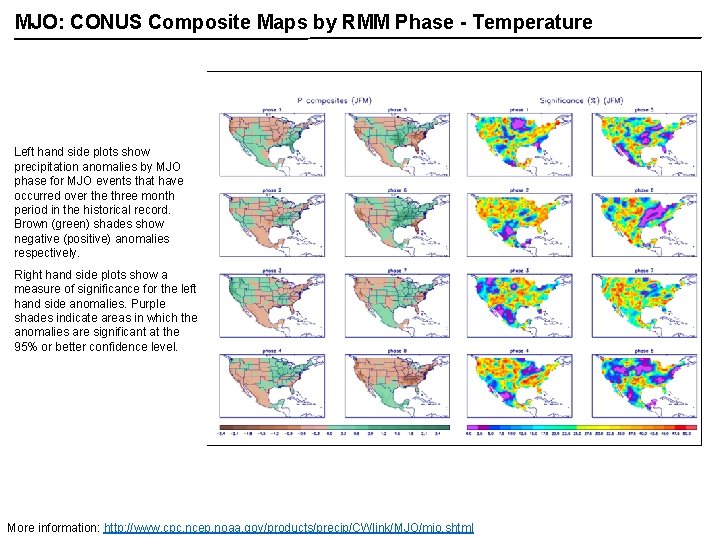
MJO: CONUS Composite Maps by RMM Phase - Temperature Left hand side plots show precipitation anomalies by MJO phase for MJO events that have occurred over the three month period in the historical record. Brown (green) shades show negative (positive) anomalies respectively. Right hand side plots show a measure of significance for the left hand side anomalies. Purple shades indicate areas in which the anomalies are significant at the 95% or better confidence level. More information: http: //www. cpc. ncep. noaa. gov/products/precip/CWlink/MJO/mjo. shtml