INTERPRETATION GUIDE TO MSG WATER VAPOUR CHANNELS Christo




- Slides: 100

INTERPRETATION GUIDE TO MSG WATER VAPOUR CHANNELS Christo Georgiev Patrick Santurette National Institute of Meteorology & Hydrology, Bulgaria Météo-France PART II Interpretation of 6. 2 m channel radiance in image format · WV imagery analysis related to PV concept · WV imagery features related to synoptic dynamical structures

Acknowledgments The Interpretation Guide to MSG WV Channels is developed by Christo Georgiev and Patrick Santurette through the Water Vapour Imagery Project of the bilateral cooperation between Météo-France and the National Institute of Meteorology and Hydrology of Bulgaria. The illustrations made by using satellite imagery from Meteosat satellites of EUMETSAT, other observational data and numerical model fields are the property of Météo-France, which has funded the work on the manual. This training tool is submitted to EUMETSAT as a contribution of France and Bulgaria to the MSG Interpretation Guide.

The Interpretation Guide to MSG WV Channels is drawn on brief excerpts from Chapters 1 -3 and Appendix A of the book: Published by Academic Press Copyright © 2005, Elsevier Inc. Chapter 4 of the book is unique in bringing together the interpretation of • water vapor images, • potential vorticity fields and • model diagnostics as a guide to validating numerical model analyses or short period forecasts. More information is available at: http: //books. elsevier. com/earthscience/ Patrick Santurette, Météo-France Christo Georgiev, NIMH, Bulgaria

WV Imagery Analysis Many pixels are considered as patterns and features of grey shades. The interpretation is aimed to relate the patterns of different moisture distribution and their changes with time to specific atmospheric circulation systems and processes.

WV channel radiance in image format • Of the two MSG WV channels, the radiation in 6. 2 m band is more highly absorbed by water vapour and, being presented in image format, it better reflects moisture content of the troposphere. • Therefore, the 6. 2 m radiation measurements are the most relevant of the WV channels to be displayed and used in image format.

Operational use of WV imagery • The WV channel radiance in 6. 2 m of MSG (6. 3 m of Meteosat 1 -7) is closely correlated with humidity field in the layer between 600 and 300 h. Pa and provides information on the flow patterns at middle and upper troposphere. • Therefore, WV imagery may serve as a tool for operational synoptic scale analysis.

Association of light and dark imagery features to dynamical structures • On a water vapour (WV) image being displayed in grey shades, the areas of dry upper-troposphere appear darker, and the areas of higher moisture content appear lighter. • The basis for synoptic scale applications of WV imagery is that moist and dry regions as well as the boundaries between them often relate to significant upper-level flow features such as troughs, deformation zones and jet streams.

DYNAMIC APPROACH FOR WV IMAGERY INTERPRETATION • An useful approach is interpreting satellite imagery jointly with various dynamical fields for the purposes of operational forecasting. • In order to perform dynamic water vapour imagery analysis, it calls for applying relevant dynamical concepts.

WATER VAPOUR IMAGERY ANALYSIS RELATED TO PV CONCEPT

A simple isentropic coordinate version of PV , where: is the air mass density in xy space potential temperature, p pressure, g is the acceleration due to the gravity. is the absolute isentropic vorticity Potential vorticity is a product of the absolute vorticity and the static stability.

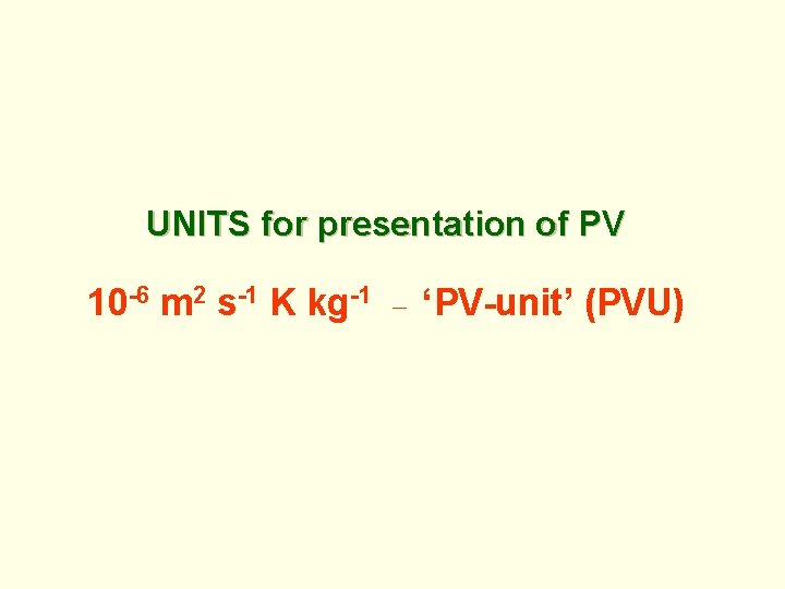
UNITS for presentation of PV 10 -6 m 2 s-1 K kg-1 ‘PV-unit’ (PVU)

• Potential vorticity is an effective dynamical parameter for studying the appearance and evolution of dynamical structures at synoptic scale due to the following important properties: • Conservation for adiabatic frictionless motions, and • Specific climate distribution in the atmosphere

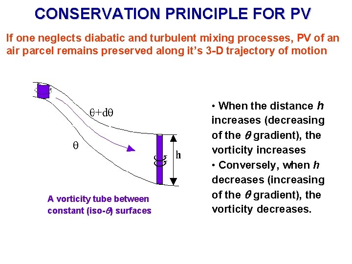
CONSERVATION PRINCIPLE FOR PV If one neglects diabatic and turbulent mixing processes, PV of an air parcel remains preserved along it’s 3 -D trajectory of motion A vorticity tube between constant (iso- ) surfaces • When the distance h increases (decreasing of the gradient), the vorticity increases • Conversely, when h decreases (increasing of the gradient), the vorticity decreases.

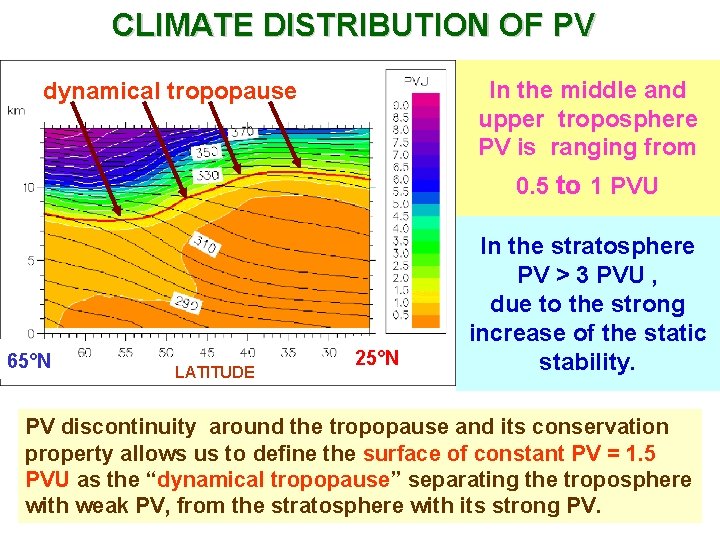
CLIMATE DISTRIBUTION OF PV In the middle and upper troposphere PV is ranging from dynamical tropopause 0. 5 to 1 PVU 65°N LATITUDE 25°N In the stratosphere PV > 3 PVU , due to the strong increase of the static stability. PV discontinuity around the tropopause and its conservation property allows us to define the surface of constant PV = 1. 5 PVU as the “dynamical tropopause” separating the troposphere with weak PV, from the stratosphere with its strong PV.

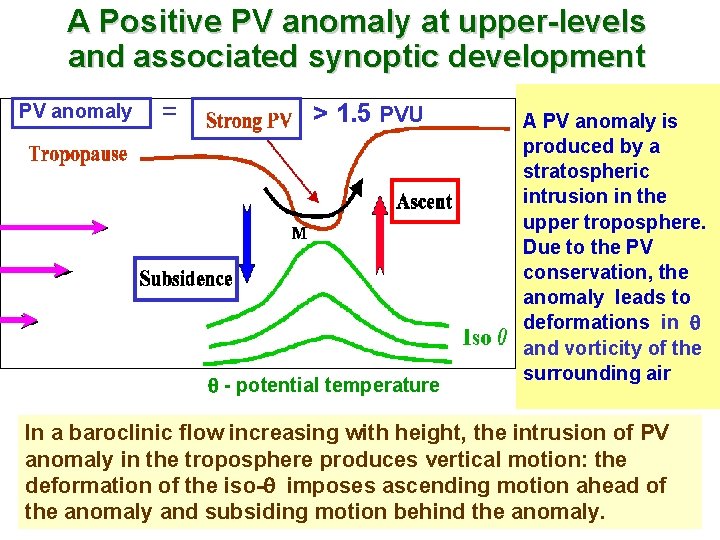
A Positive PV anomaly at upper-levels and associated synoptic development PV anomaly = > 1. 5 PVU - potential temperature A PV anomaly is produced by a stratospheric intrusion in the upper troposphere. Due to the PV conservation, the anomaly leads to deformations in and vorticity of the surrounding air In a baroclinic flow increasing with height, the intrusion of PV anomaly in the troposphere produces vertical motion: the deformation of the iso- imposes ascending motion ahead of the anomaly and subsiding motion behind the anomaly.

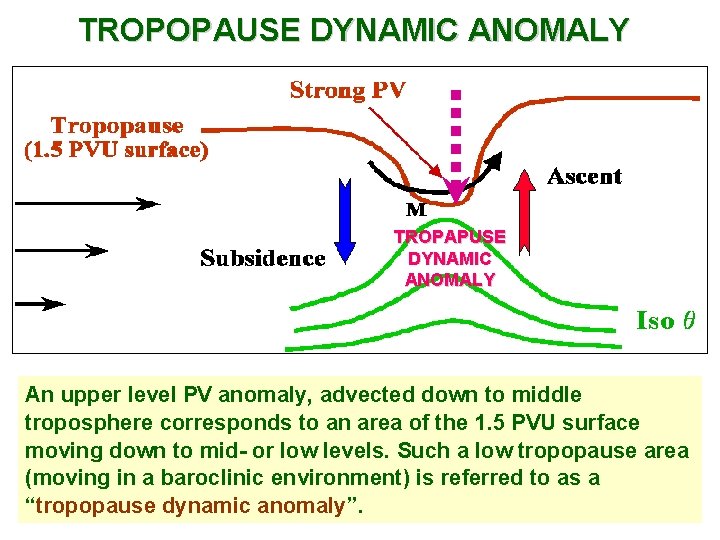
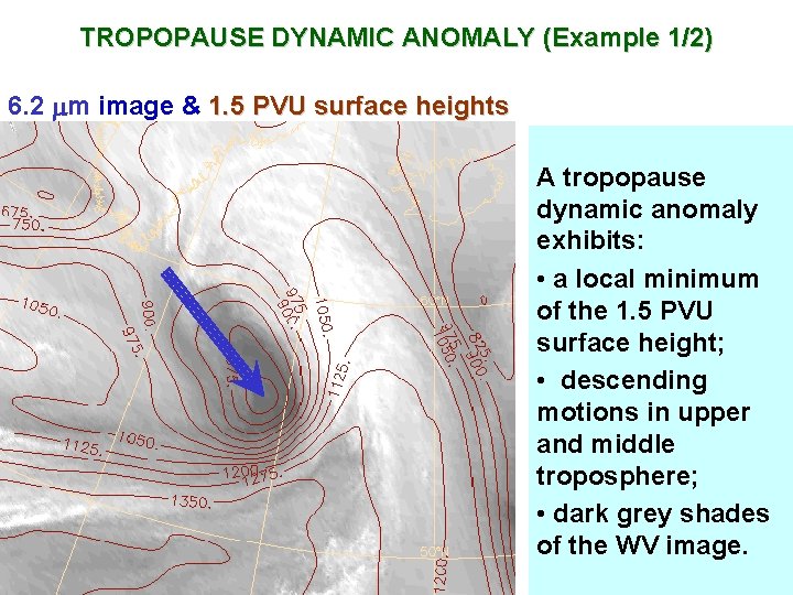
TROPOPAUSE DYNAMIC ANOMALY TROPAPUSE DYNAMIC ANOMALY An upper level PV anomaly, advected down to middle troposphere corresponds to an area of the 1. 5 PVU surface moving down to mid- or low levels. Such a low tropopause area (moving in a baroclinic environment) is referred to as a “tropopause dynamic anomaly”.

TROPOPAUSE DYNAMIC ANOMALY (Example 1/2) 6. 2 m image & 1. 5 PVU surface heights A tropopause dynamic anomaly exhibits: • a local minimum of the 1. 5 PVU surface height; • descending motions in upper and middle troposphere; • dark grey shades of the WV image.

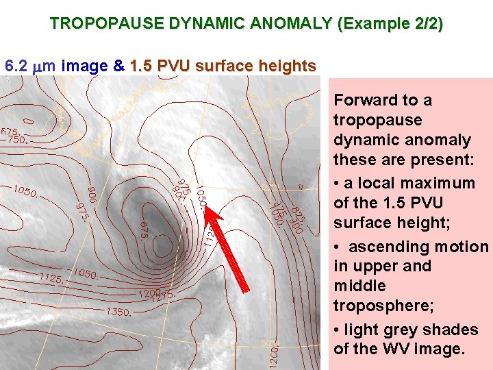
TROPOPAUSE DYNAMIC ANOMALY (Example 2/2) 6. 2 m image & 1. 5 PVU surface heights Forward to a tropopause dynamic anomaly these are present: • a local maximum of the 1. 5 PVU surface height; • ascending motion in upper and middle troposphere; • light grey shades of the WV image.

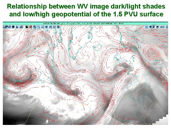
Relationship between WV image dark/light shades and low/high geopotential of the 1. 5 PVU surface

OPERATIONAL TOOLS WV imagery is a tool for upper-level diagnosis. Efficient approaches for imagery analysis in forecasting environment are: • Superimposing WV images on upper level dynamical fields, derived by NWP models, e. g. 1. 5 PVU surface heights; 300 h. Pa wind field. • Imagery interpretation with reference to • Vertical cross-sections of NWP modelderived PV and relative humidity. • Observational data derived by upper-air soundings.

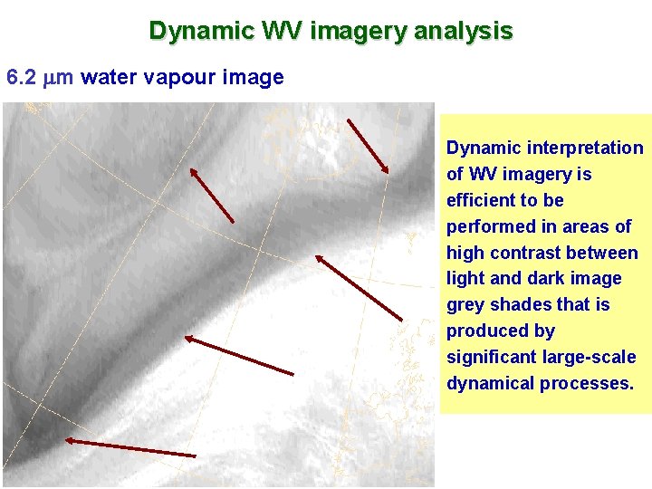
Dynamic WV imagery analysis 6. 2 m water vapour image Dynamic interpretation of WV imagery is efficient to be performed in areas of high contrast between light and dark image grey shades that is produced by significant large-scale dynamical processes.

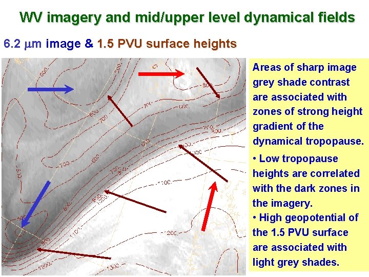
WV imagery and mid/upper level dynamical fields 6. 2 m image & 1. 5 PVU surface heights Areas of sharp image grey shade contrast are associated with zones of strong height gradient of the dynamical tropopause. • Low tropopause heights are correlated with the dark zones in the imagery. • High geopotential of the 1. 5 PVU surface are associated with light grey shades.

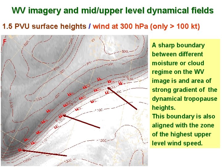
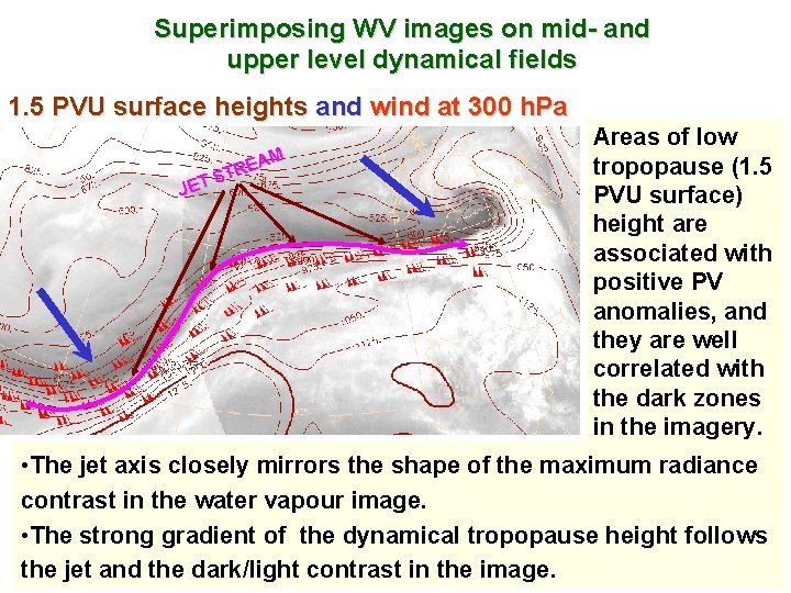
WV imagery and mid/upper level dynamical fields 1. 5 PVU surface heights / wind at 300 h. Pa (only > 100 kt) A sharp boundary between different moisture or cloud regime on the WV image is and area of strong gradient of the dynamical tropopause heights. This boundary is also aligned with the zone of the highest upper level wind speed.

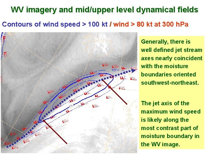
WV imagery and mid/upper level dynamical fields Contours of wind speed > 100 kt / wind > 80 kt at 300 h. Pa Generally, there is well defined jet stream axes nearly coincident with the moisture boundaries oriented southwest-northeast. The jet axis of the maximum wind speed is likely along the most contrast part of moisture boundary in the WV image.

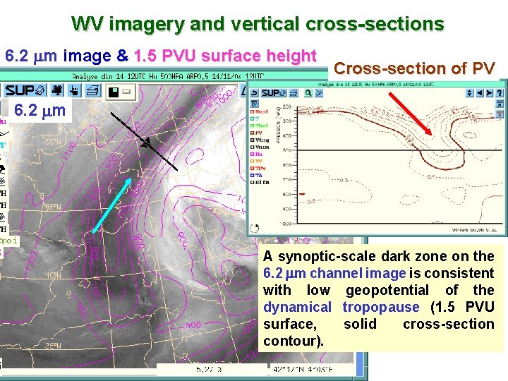
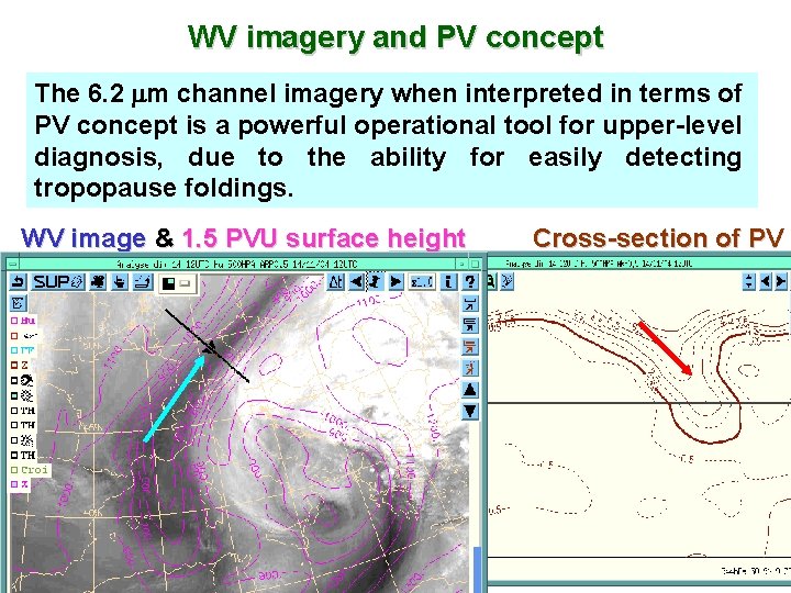
WV imagery and vertical cross-sections 6. 2 m image & 1. 5 PVU surface height Cross-section of PV 6. 2 m A synoptic-scale dark zone on the 6. 2 m channel image is consistent with low geopotential of the dynamical tropopause (1. 5 PVU surface, solid cross-section contour).

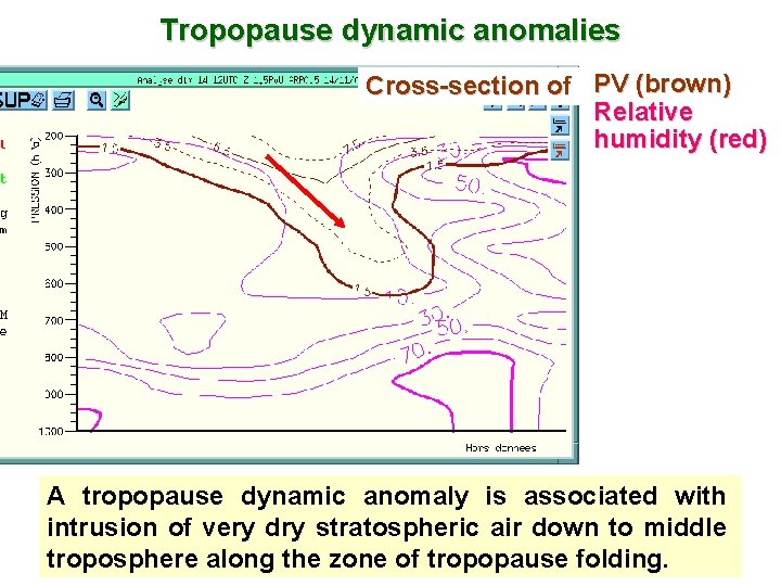
Tropopause dynamic anomalies Cross-section of PV (brown) Relative humidity (red) A tropopause dynamic anomaly is associated with intrusion of very dry stratospheric air down to middle troposphere along the zone of tropopause folding.

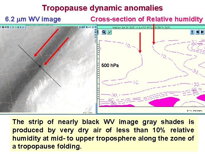
Tropopause dynamic anomalies 6. 2 m WV image Cross-section of Relative humidity 500 h. Pa The strip of nearly black WV image gray shades is produced by very dry air of less than 10% relative humidity at mid- to upper troposphere along the zone of a tropopause folding.

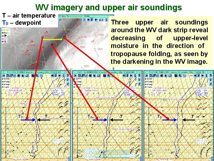
WV imagery and upper air soundings T – air temperature TD – dewpoint TD T Three upper air soundings around the WV dark strip reveal decreasing of upper-level moisture in the direction of tropopause folding, as seen by the darkening in the WV image. TD T

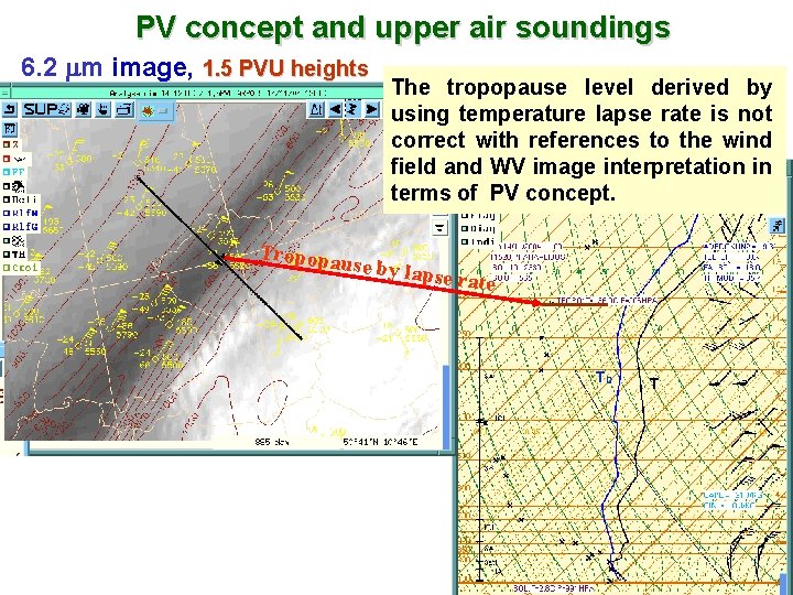
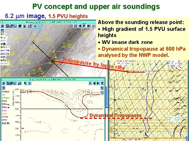
PV concept and upper air soundings 6. 2 m image, 1. 5 PVU heights Tropopa The tropopause level derived by using temperature lapse rate is not correct with references to the wind field and WV image interpretation in terms of PV concept. use by la pse rate TD T

PV concept and upper air soundings 6. 2 m image, 1. 5 PVU heights Tropopa Above the sounding release point: · High gradient of 1. 5 PVU surface heights · WV image dark zone · Dynamical tropopause at 600 h. Pa analysed by the NWP model. use by l apse rat e TD Dynamical Tropopause T

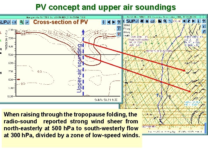
PV concept and upper air soundings Upper-air sounding Cross-section of PV TD When raising through the tropopause folding, the radio-sound reported strong wind sheer from north-easterly at 500 h. Pa to south-westerly flow at 300 h. Pa, divided by a zone of low-speed winds. T

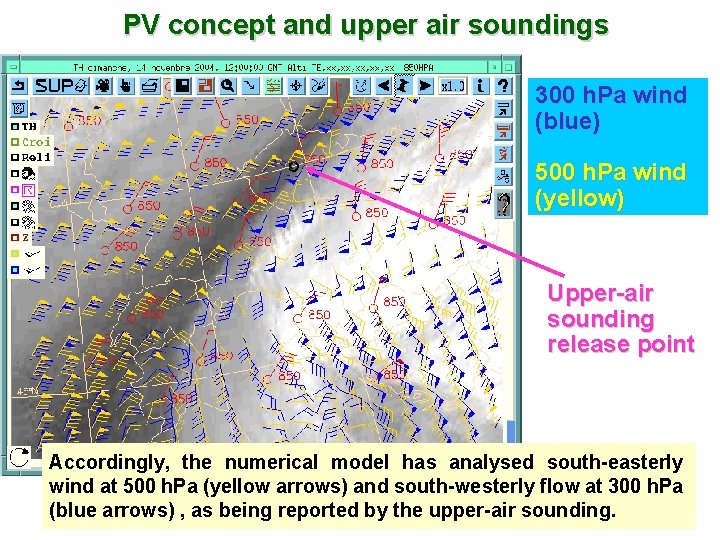
PV concept and upper air soundings 300 h. Pa wind (blue) 500 h. Pa wind (yellow) Upper-air sounding release point Accordingly, the numerical model has analysed south-easterly wind at 500 h. Pa (yellow arrows) and south-westerly flow at 300 h. Pa (blue arrows) , as being reported by the upper-air sounding.

WV imagery and PV concept The 6. 2 m channel imagery when interpreted in terms of PV concept is a powerful operational tool for upper-level diagnosis, due to the ability for easily detecting tropopause foldings. WV image & 1. 5 PVU surface height Cross-section of PV

Superimposing WV images on mid- and upper level dynamical fields 1. 5 PVU surface heights and wind at 300 h. Pa EAM R T S JET Areas of low tropopause (1. 5 PVU surface) height are associated with positive PV anomalies, and they are well correlated with the dark zones in the imagery. • The jet axis closely mirrors the shape of the maximum radiance contrast in the water vapour image. • The strong gradient of the dynamical tropopause height follows the jet and the dark/light contrast in the image.

WATER VAPOUR IMAGERY ANALYSIS WV IMAGERY FEATURES RELATED TO SYNOPTIC DINAMICAL STRUCTURES

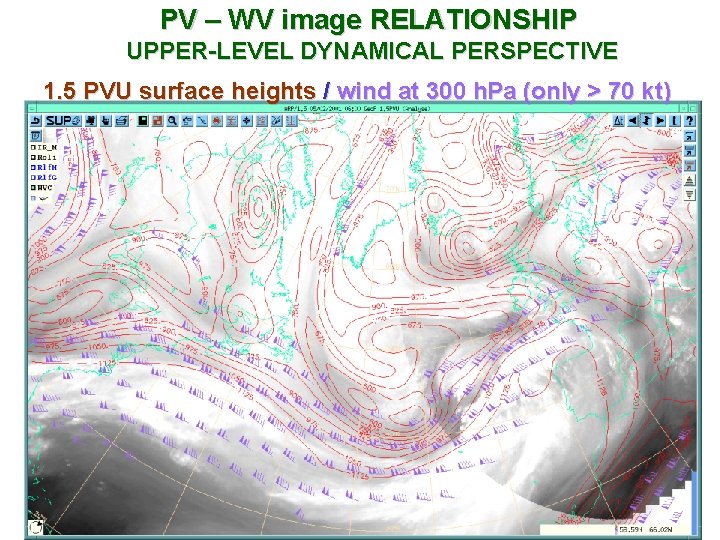
WV CHANNEL RADIANCE RELATED TO UPPER-LEVEL DYNAMICS F Radiance in 6. 2 m channel is related to the synoptic-scale motion field above 600 h. Pa and thus it is sensitive to the following upper level dynamical features: Ä Upper level jet Ä Upper level PV (dynamic tropopause) anomaly Ä Synoptic vertical motion ü areas of ascending air = white zones ü areas of subsiding air = dark zones F upper level PV / dynamic tropopause anomaly = dark zones F jet streak / strong gradient of 1. 5 PVU surface heights = strong humidity gradient in the imagery (dry air on polar side)

PV – WV image RELATIONSHIP UPPER-LEVEL DYNAMICAL PERSPECTIVE 1. 5 PVU surface heights / wind at 300 h. Pa (only > 70 kt)

JET-STREAM RELATED PATERNS • Being upper-level dynamical structures, the jet systems are related to characteristic cloud and moisture regimes that are well seen in the WV imagery.

JET-STREAM RELATED PATERNS • The jet streams are important dynamical features of the synoptic scale circulation. • One of the most efficient use of WV imagery for weather forecasting is to observe the structure and evolution of the jet stream zones in association with the dynamical tropopause behaviour by applying the PV concept. • Changes in the jet stream and the height of the dynamical tropopause may be considered to predict time changes in the related circulation systems and may provide early indication of NWP model validity.

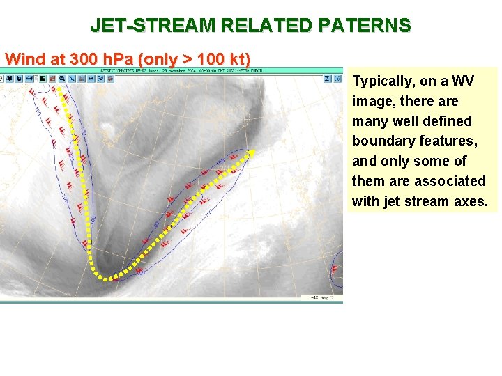
JET-STREAM RELATED PATERNS Wind at 300 h. Pa (only > 100 kt) Typically, on a WV image, there are many well defined boundary features, and only some of them are associated with jet stream axes.

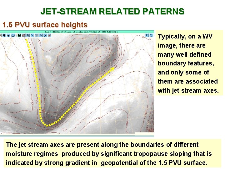
JET-STREAM RELATED PATERNS 1. 5 PVU surface heights Typically, on a WV image, there are many well defined boundary features, and only some of them are associated with jet stream axes. The jet stream axes are present along the boundaries of different moisture regimes produced by significant tropopause sloping that is indicated by strong gradient in geopotential of the 1. 5 PVU surface.

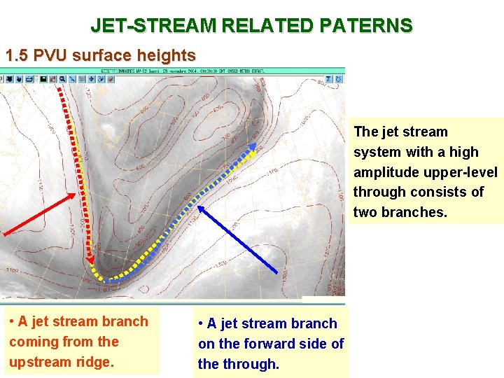
JET-STREAM RELATED PATERNS 1. 5 PVU surface heights The jet stream system with a high amplitude upper-level through consists of two branches. • A jet stream branch coming from the upstream ridge. • A jet stream branch on the forward side of the through.

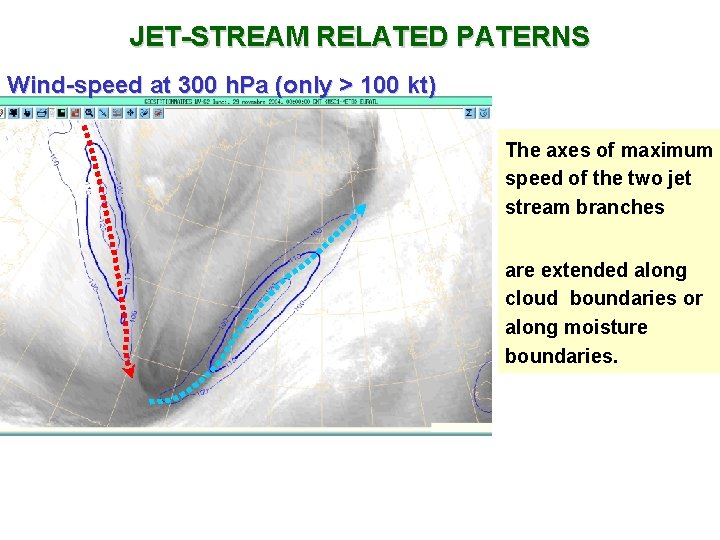
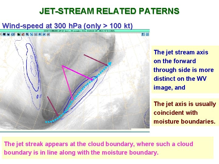
JET-STREAM RELATED PATERNS Wind-speed at 300 h. Pa (only > 100 kt) The axes of maximum speed of the two jet stream branches are extended along cloud boundaries or along moisture boundaries.

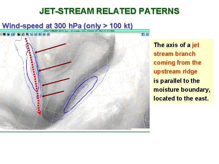
JET-STREAM RELATED PATERNS Wind-speed at 300 h. Pa (only > 100 kt) The axis of a jet stream branch coming from the upstream ridge is parallel to the moisture boundary, located to the east.

JET-STREAM RELATED PATERNS Wind-speed at 300 h. Pa (only > 100 kt) The jet stream axis on the forward through side is more distinct on the WV image, and The jet axis is usually coincident with moisture boundaries. The jet streak appears at the cloud boundary, where such a cloud boundary is in line along with the moisture boundary.

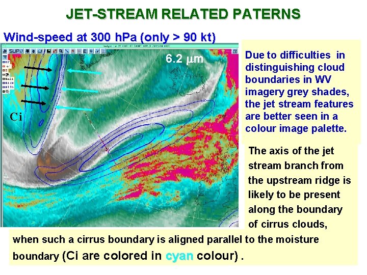
JET-STREAM RELATED PATERNS Wind-speed at 300 h. Pa (only > 90 kt) 6. 2 m Ci Due to difficulties in distinguishing cloud boundaries in WV imagery grey shades, the jet stream features are better seen in a colour image palette. The axis of the jet stream branch from the upstream ridge is likely to be present along the boundary of cirrus clouds, when such a cirrus boundary is aligned parallel to the moisture boundary (Ci are colored in cyan colour) . cyan

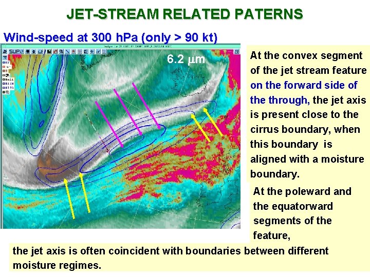
JET-STREAM RELATED PATERNS Wind-speed at 300 h. Pa (only > 90 kt) 6. 2 m At the convex segment of the jet stream feature on the forward side of the through, the jet axis is present close to the cirrus boundary, when this boundary is aligned with a moisture boundary. At the poleward and the equatorward segments of the feature, the jet axis is often coincident with boundaries between different moisture regimes.

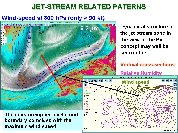
JET-STREAM RELATED PATERNS Wind-speed at 300 h. Pa (only > 90 kt) 6. 2 m Dynamical structure of the jet stream zone in the view of the PV concept may well be seen in the Vertical cross-sections Relative Humidity Wind speed The moisture/upper-level cloud boundary coincides with the maximum wind speed

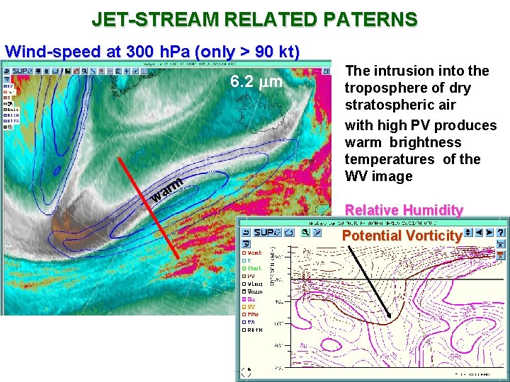
JET-STREAM RELATED PATERNS Wind-speed at 300 h. Pa (only > 90 kt) 6. 2 m m r a w The intrusion into the troposphere of dry stratospheric air with high PV produces warm brightness temperatures of the WV image Relative Humidity Potential Vorticity

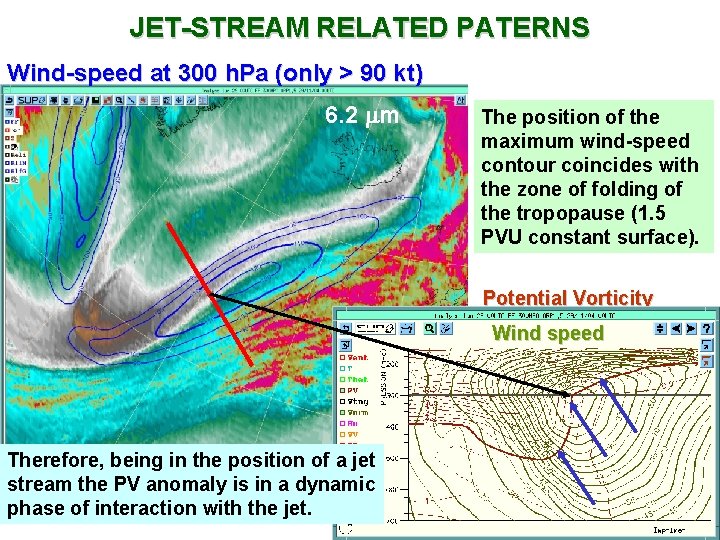
JET-STREAM RELATED PATERNS Wind-speed at 300 h. Pa (only > 90 kt) 6. 2 m The position of the maximum wind-speed contour coincides with the zone of folding of the tropopause (1. 5 PVU constant surface). Potential Vorticity Wind speed Therefore, being in the position of a jet stream the PV anomaly is in a dynamic phase of interaction with the jet.

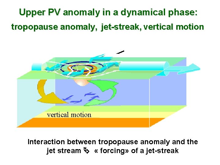
Upper PV anomaly in a dynamical phase: tropopause anomaly, jet-streak, vertical motion Interaction between tropopause anomaly and the jet stream « forcing» of a jet-streak

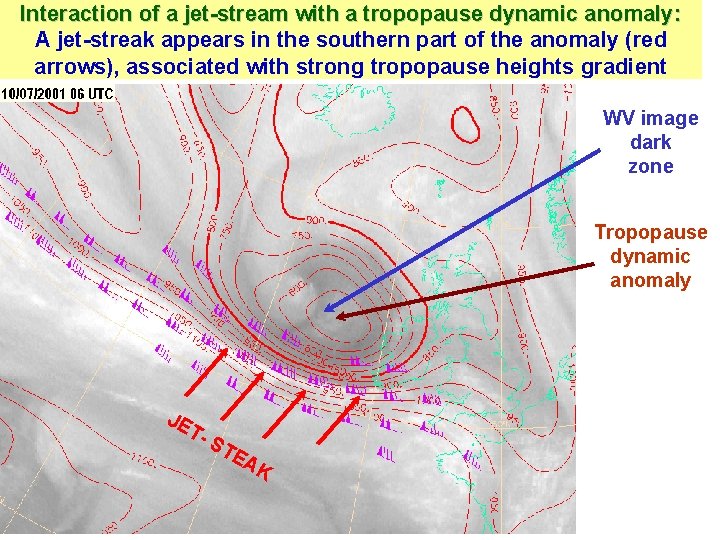
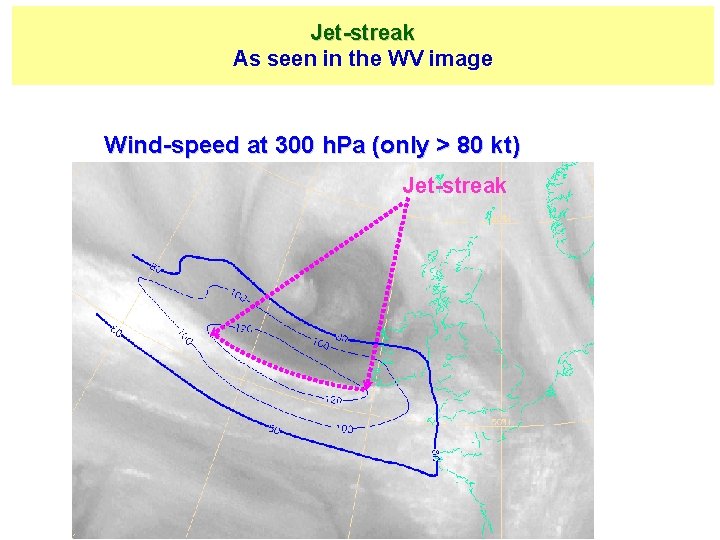
INTERACTION OF THE JET STREAM WITH A TROPOPAUSE DYNAMIC ANOMALY WV imagery is a tool for observing tropopause dynamic anomalies and jet streams in the context of their interaction, which is critical for the evolution of the synoptic situation.

Interaction of a jet-stream with a tropopause dynamic anomaly: A jet-streak appears in the southern part of the anomaly (red arrows), associated with strong tropopause heights gradient WV image dark zone Tropopause dynamic anomaly JE T- ST EA K

Jet-streak As seen in the WV image Wind-speed at 300 h. Pa (only > 80 kt) Jet-streak

CYCLOGENESIS • WV imagery is an operational tool for studying the cyclogenesis, from the very beginning of the process (about 24 to 48 hours before the onset of surface deepening) to the decay of the low system, as well as during any periods of reinforcement.

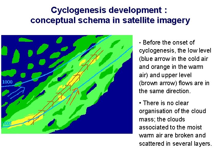
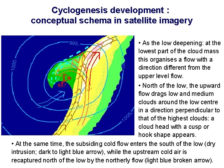
Cyclogenesis development : conceptual schema in satellite imagery • Before the onset of cyclogenesis, the low level (blue arrow in the cold air and orange in the warm air) and upper level (brown arrow) flows are in the same direction. • There is no clear organisation of the cloud mass; the clouds associated to the moist warm air are broken and scattered in several layers.

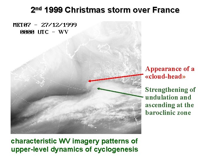
Cyclogenesis development : conceptual schema in satellite imagery • As the low deepening: at the lowest part of the cloud mass this organises a flow with a direction different from the upper level flow. • North of the low, the upward flow drags low and medium clouds around the low centre in a direction perpendicular to that of the highest clouds: a cloud head with a cusp or hook shape appears. • At the same time, the subsiding cold flow enters the south of the low (dry intrusion; dark to light blue arrow), while the upstream cold air is recaptured north of the low by the northerly flow (light blue broken arrow).

CYCLOGENESIS • WV imagery is a useful operational tool for interpretation the following different aspects concerning cyclogenesis: • Cyclogenesis with upper-level precursors. • Dry intrusion as an ingredient and a precursor of cyclogenesis. • Dry intrusion related to kata- and ana-cold fronts.

CYCLOGENESIS WITH UPPER-LEVEL PRECURSOR • Deep tropospheric cyclogenesis is a result of a baroclinic interaction between a tropopause dynamic anomaly and a jet-stream in upper level as well as a low-level baroclinic zone. • The crucial elements leading to such a cyclogenesis with an upper level precursor are observed by means of synoptic and WV imagery analyses.

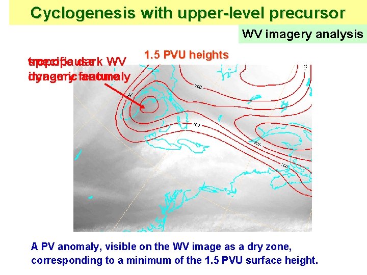
UPPER-LEVEL PRECURSOR OF CYCLOGENESIS An upper level precursor of deep tropospheric cyclogenesis is a clear isolated tropopause dynamic anomaly at an initial phase that is seen as a dry feature in the WV imagery.

Cyclogenesis with upper-level precursor WV imagery analysis tropopause specific dark WV imagery feature dynamic anomaly 1. 5 PVU heights A PV anomaly, visible on the WV image as a dry zone, corresponding to a minimum of the 1. 5 PVU surface height.

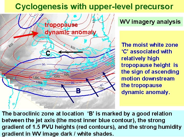
Cyclogenesis with upper-level precursor WV imagery analysis The upper-level forcing at a very initial phase of cyclogenesis is evident in the superposition of the WV image and dynamical fields.

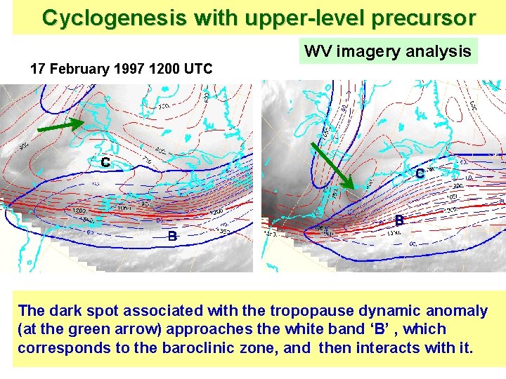
Cyclogenesis with upper-level precursor tropopause dynamic anomaly WV imagery analysis The moist white zone ‘C’ associated with relatively high tropopause height is the sign of ascending motion downstream the tropopause dynamic anomaly. The baroclinic zone at location ‘B’ is marked by a good relation between the jet axis (the most inner blue contour), the strong gradient of 1. 5 PVU heights (red contours), and the strong humidity gradient in WV image dark / white shades.

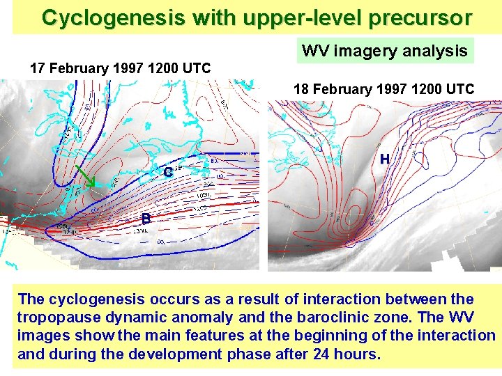
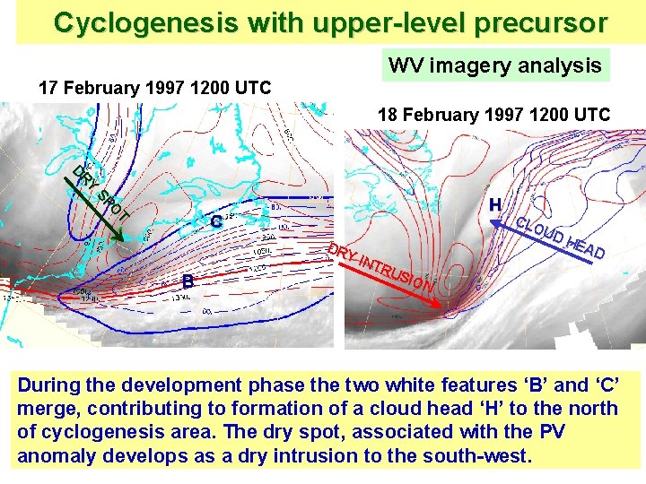
Cyclogenesis with upper-level precursor 17 February 1997 1200 UTC WV imagery analysis 18 February 1997 1200 UTC The cyclogenesis occurs as a result of interaction between the tropopause dynamic anomaly and the baroclinic zone. The WV images show the main features at the beginning of the interaction and during the development phase after 24 hours.

Cyclogenesis with upper-level precursor 17 February 1997 1200 UTC WV imagery analysis The dark spot associated with the tropopause dynamic anomaly (at the green arrow) approaches the white band ‘B’ , which corresponds to the baroclinic zone, and then interacts with it.

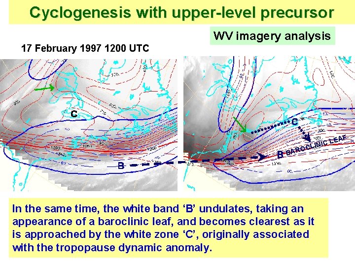
Cyclogenesis with upper-level precursor 17 February 1997 1200 UTC WV imagery analysis F LEA C I N I OCL BAR In the same time, the white band ‘B’ undulates, taking an appearance of a baroclinic leaf, and becomes clearest as it is approached by the white zone ‘C’, originally associated with the tropopause dynamic anomaly.

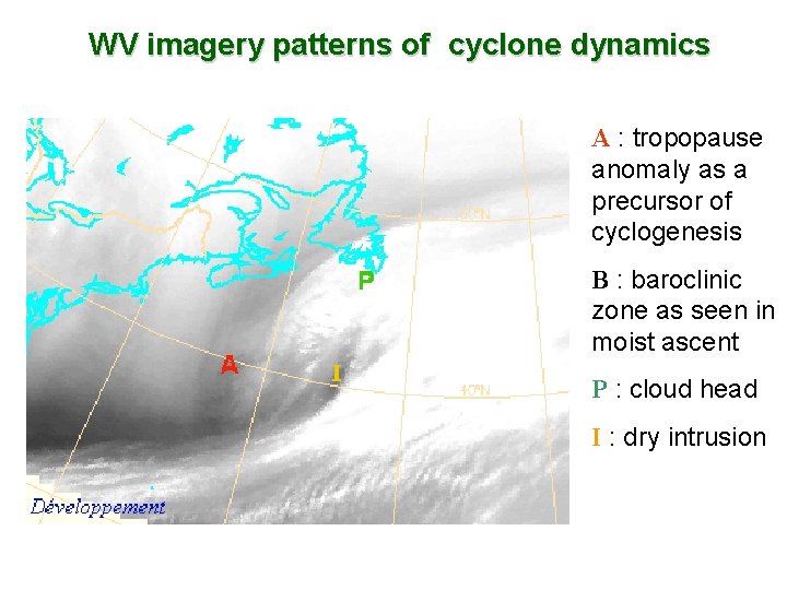
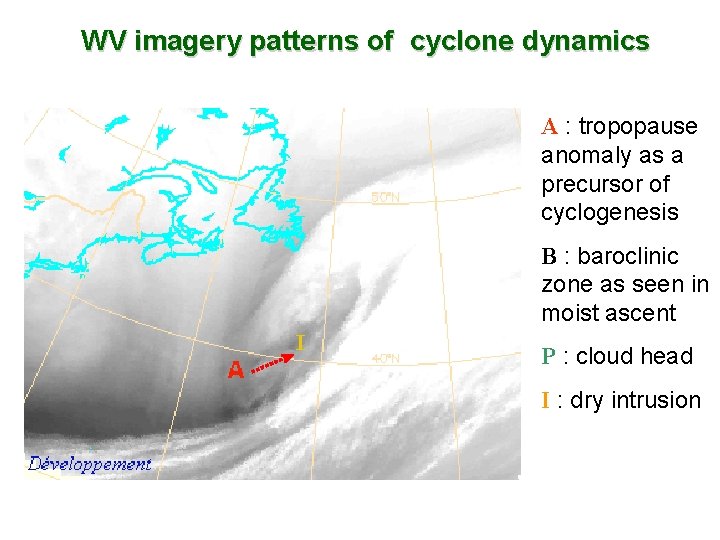
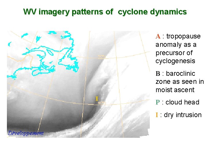
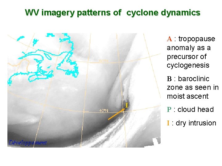
Cyclogenesis with upper-level precursor 17 February 1997 1200 UTC WV imagery analysis 18 February 1997 1200 UTC T O SP Y R D DR Y IN TRU SIO N CLO UD HE AD During the development phase the two white features ‘B’ and ‘C’ merge, contributing to formation of a cloud head ‘H’ to the north of cyclogenesis area. The dry spot, associated with the PV anomaly develops as a dry intrusion to the south-west.

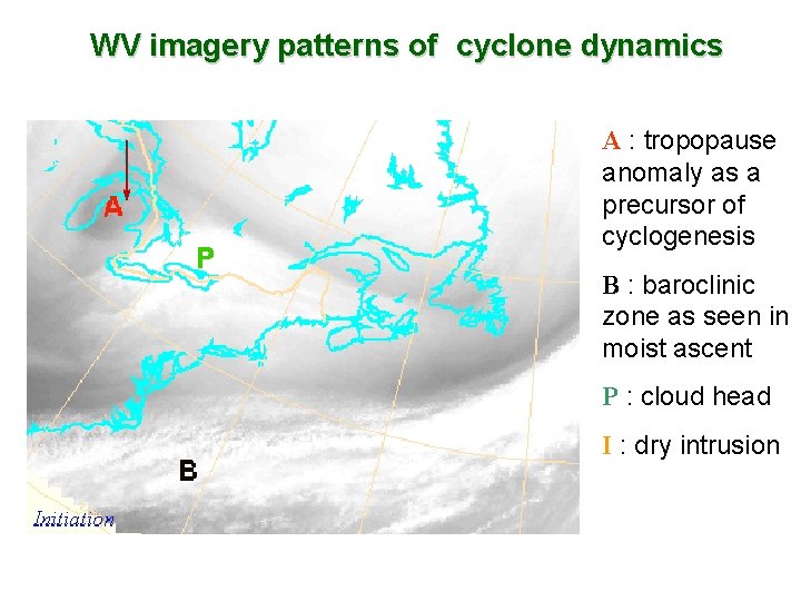
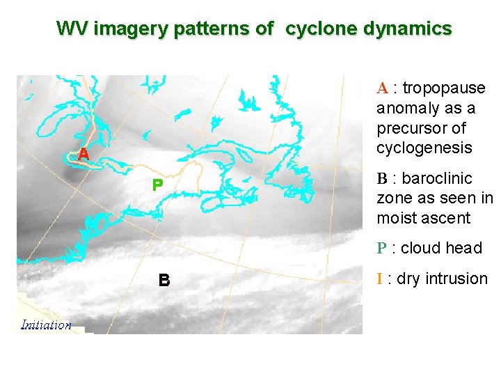
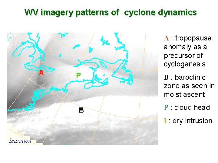
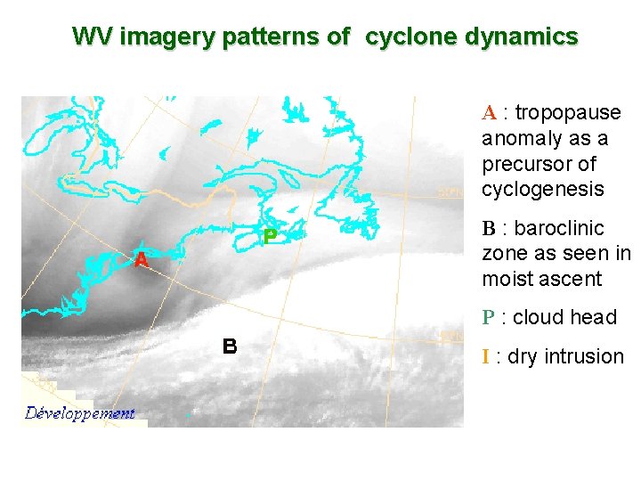
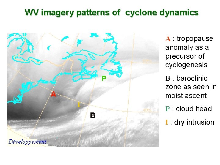
WV imagery patterns of cyclone dynamics A : tropopause anomaly as a precursor of cyclogenesis B : baroclinic zone as seen in moist ascent P : cloud head I : dry intrusion

WV imagery patterns of cyclone dynamics A : tropopause anomaly as a precursor of cyclogenesis B : baroclinic zone as seen in moist ascent P : cloud head I : dry intrusion

WV imagery patterns of cyclone dynamics A : tropopause anomaly as a precursor of cyclogenesis B : baroclinic zone as seen in moist ascent P : cloud head I : dry intrusion

WV imagery patterns of cyclone dynamics A : tropopause anomaly as a precursor of cyclogenesis B : baroclinic zone as seen in moist ascent P : cloud head I : dry intrusion

WV imagery patterns of cyclone dynamics A : tropopause anomaly as a precursor of cyclogenesis B : baroclinic zone as seen in moist ascent P : cloud head I : dry intrusion

WV imagery patterns of cyclone dynamics A : tropopause anomaly as a precursor of cyclogenesis B : baroclinic zone as seen in moist ascent P : cloud head I : dry intrusion

WV imagery patterns of cyclone dynamics A : tropopause anomaly as a precursor of cyclogenesis B : baroclinic zone as seen in moist ascent P : cloud head I : dry intrusion

WV imagery patterns of cyclone dynamics A : tropopause anomaly as a precursor of cyclogenesis B : baroclinic zone as seen in moist ascent P : cloud head I : dry intrusion

WV imagery patterns of cyclone dynamics A : tropopause anomaly as a precursor of cyclogenesis B : baroclinic zone as seen in moist ascent P : cloud head I : dry intrusion

WV IMAGERY PATTERNS OF CYCLONE DYNAMICS • Moist ascent at the baroclinic zone • Cloud-head • Dry intrusion • Kata- and ana-cold fronts

DRY SPOT and DRY INTRUSION as characteristic WV imagery patterns of the upper-level dynamics of cyclogenesis • Deep tropospheric cyclogenesis is associated with a dry spot on the WV imagery as an upper level precursor. • Dry intrusion appears in the leading zone of the dry spot when cyclogenesis develops.

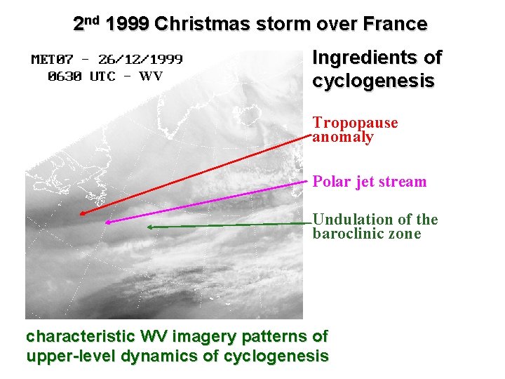
2 nd 1999 Christmas storm over France WV Ingredients of cyclogenesis Tropopause anomaly Polar jet stream Undulation of the baroclinic zone characteristic WV imagery patterns of upper-level dynamics of cyclogenesis

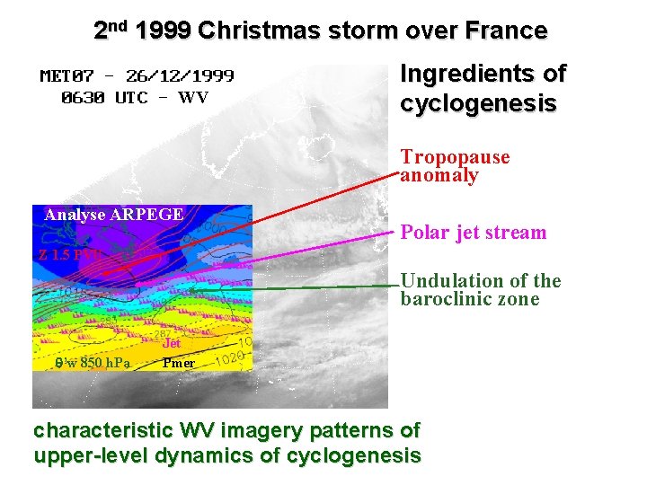
2 nd 1999 Christmas storm over France WV Ingredients of cyclogenesis Tropopause anomaly Analyse ARPEGE Polar jet stream Z 1. 5 PVU Undulation of the baroclinic zone ’w 850 h. Pa Jet Pmer characteristic WV imagery patterns of upper-level dynamics of cyclogenesis

2 nd 1999 Christmas storm over France WV Appearance of a «cloud-head» Strengthening of undulation and ascending at the baroclinic zone characteristic WV imagery patterns of upper-level dynamics of cyclogenesis

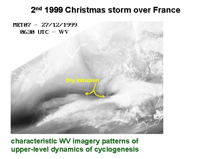
2 nd 1999 Christmas storm over France WV Dry Intrusion characteristic WV imagery patterns of upper-level dynamics of cyclogenesis

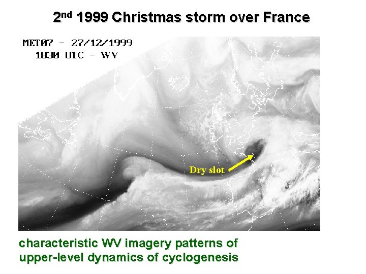
2 nd 1999 Christmas storm over France WV Dry slot characteristic WV imagery patterns of upper-level dynamics of cyclogenesis

DRY SPOT, DRY INTRUSION and DRY SLOT: characteristic WV imagery patterns of upper -level dynamics of cyclogenesis • The dry spot is associated with descending motions at upper levels linked to a tropopause dynamic anomaly. • During the development of cyclogenesis the dry spot extended in the WV imagery leading to a dry intrusion associated with further expanding of subsiding motion. • A dry slot appears as a part of the descending air entering to the southwest of the surface low.

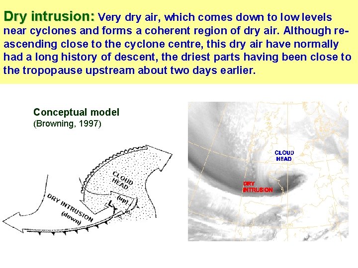
Dry intrusion: Very dry air, which comes down to low levels near cyclones and forms a coherent region of dry air. Although reascending close to the cyclone centre, this dry air have normally had a long history of descent, the driest parts having been close to the tropopause upstream about two days earlier. Conceptual model (Browning, 1997)

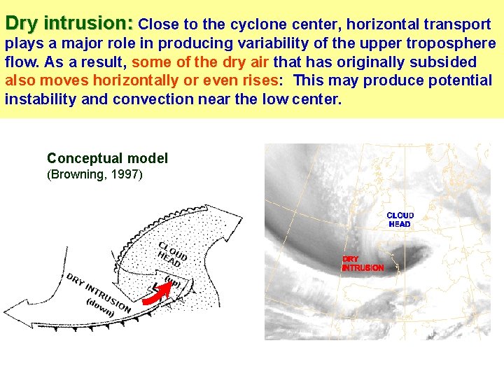
Dry intrusion: Close to the cyclone center, horizontal transport plays a major role in producing variability of the upper troposphere flow. As a result, some of the dry air that has originally subsided also moves horizontally or even rises: This may produce potential instability and convection near the low center. Conceptual model (Browning, 1997)

IDENTIFICATION OF DRY INTRUSION FROM WV IMAGERY WV imagery is a tool for identifying dry intrusions and it is useful for operational purposes: • Monitoring dry intrusions may help the forecaster to understand what is happening on the mesoscale and to anticipate what may happen over a period of a nowcast. • This is especially valuable in situations of rapid cyclogenesis, associated with convective activity, when local warnings are needed.

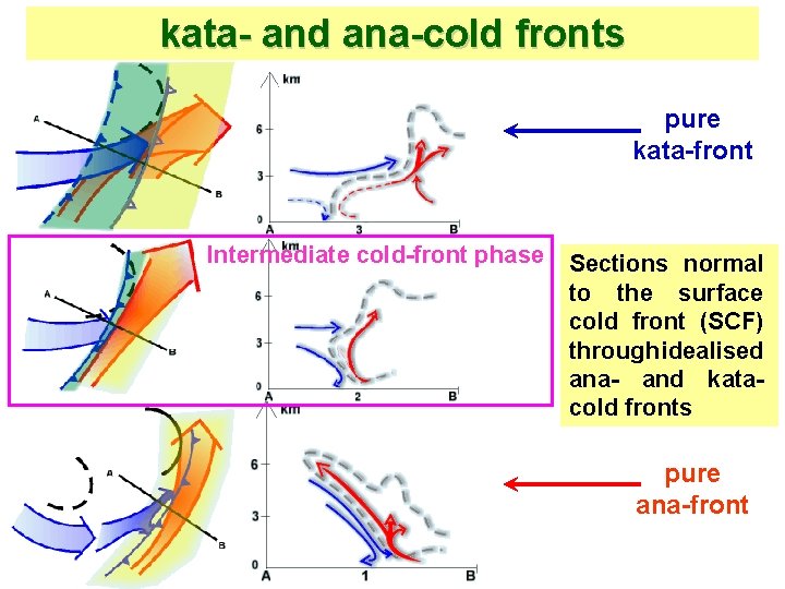
Dry intrusion and kata- and ana-cold fronts • As regards to the WV imagery analysis of the dry intrusion, it is appropriate to be considered in relation to the conceptual models of kata- and ana-cold fronts. • By means of a joint interpretation of WV imagery and model fields, we are able to note important characteristics of the frontal system.

kata- and ana-cold fronts pure kata-front Intermediate cold-front phase Sections normal to the surface cold front (SCF) through idealised ana- and kata- cold fronts pure ana-front

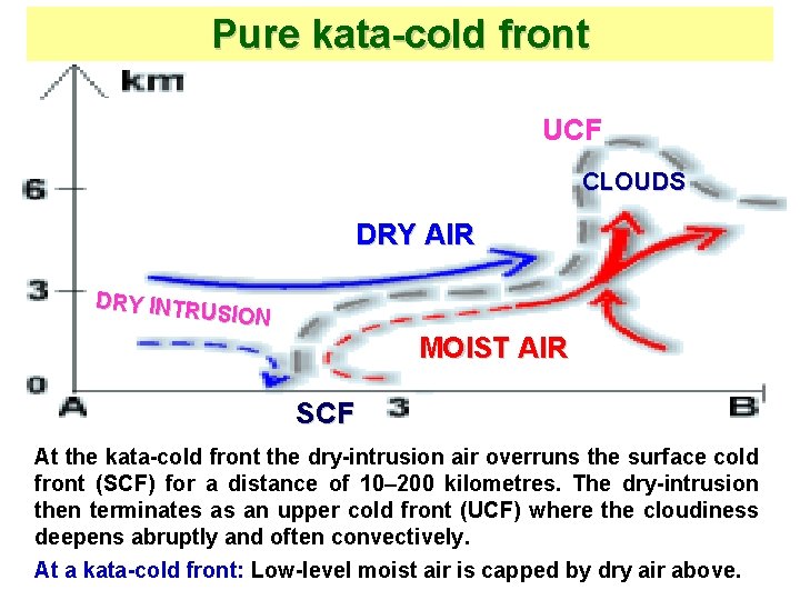
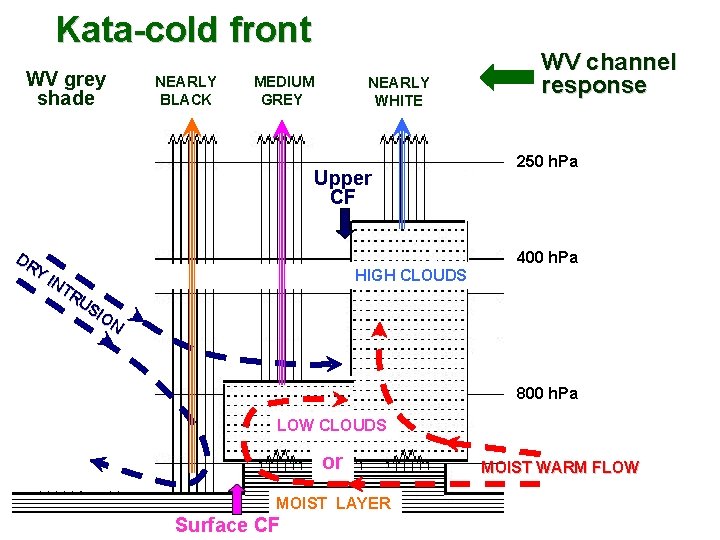
Pure kata-cold front UCF CLOUDS DRY AIR DRY INTRU SION MOIST AIR SCF At the kata-cold front the dry-intrusion air overruns the surface cold front (SCF) for a distance of 10– 200 kilometres. The dry-intrusion then terminates as an upper cold front (UCF) where the cloudiness deepens abruptly and often convectively. At a kata-cold front: Low-level moist air is capped by dry air above.

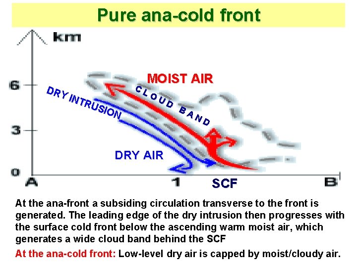
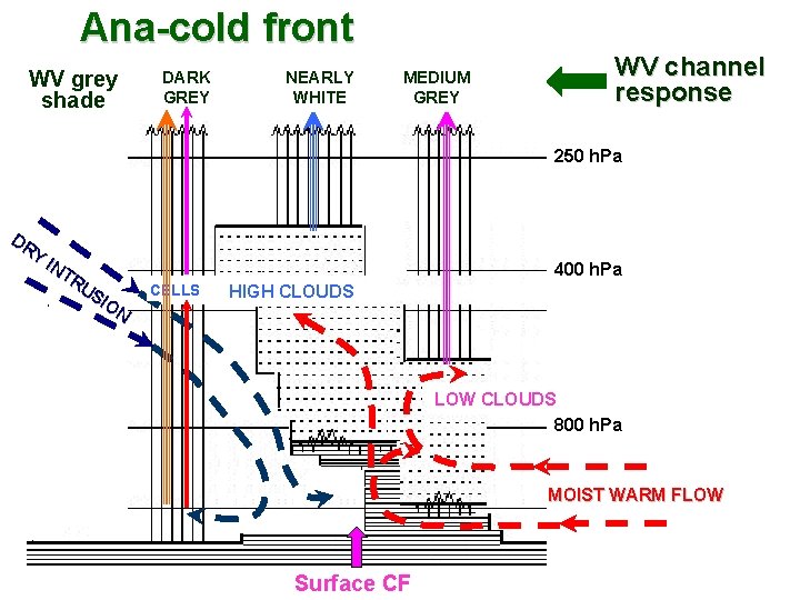
Pure ana-cold front DRY INT RUS ION MOIST AIR C L O U D B A N D DRY AIR SCF At the ana-front a subsiding circulation transverse to the front is generated. The leading edge of the dry intrusion then progresses with the surface cold front below the ascending warm moist air, which generates a wide cloud band behind the SCF At the ana-cold front: Low-level dry air is capped by moist/cloudy air.

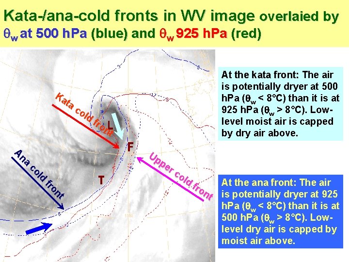
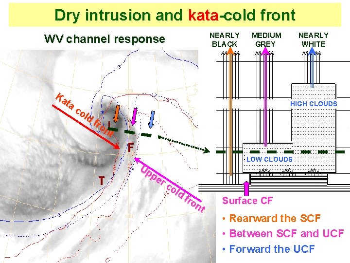
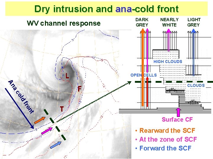
Kata-/ana-cold fronts in WV image overlaied by w at 500 h. Pa (blue) and w 925 h. Pa (red) At the kata front: The air front: is potentially dryer at 500 h. Pa ( w < 8°C) than it is at 925 h. Pa ( w > 8°C). Lowlevel moist air is capped by dry air above. Ka ta co ld fr on t t on fr d ol c na A Up pe r c ol d fro nt At the ana front: The air front: is potentially dryer at 925 h. Pa ( w < 8°C) than it is at 500 h. Pa ( w > 8°C). Lowlevel dry air is capped by moist air above.

Kata-cold front WV grey shade NEARLY BLACK MEDIUM GREY NEARLY WHITE Upper CF DR Y IN TR US IO N WV channel response 250 h. Pa 400 h. Pa HIGH CLOUDS 800 h. Pa LOW CLOUDS or MOIST LAYER Surface CF MOIST WARM FLOW

Ana-cold front WV grey shade DARK GREY NEARLY WHITE MEDIUM GREY WV channel response 250 h. Pa DR Y IN TR US IO N 400 h. Pa CELLS HIGH CLOUDS LOW CLOUDS 800 h. Pa MOIST WARM FLOW Surface CF

Dry intrusion and kata-cold front WV channel response NEARLY BLACK MEDIUM GREY Ka ta co ld fr on t NEARLY WHITE HIGH CLOUDS Up pe r c old fr on t LOW CLOUDS Surface CF • Rearward the SCF • Between SCF and UCF • Forward the UCF

Dry intrusion and ana-cold front WV channel response DARK GREY NEARLY WHITE LIGHT GREY HIGH CLOUDS OPEN CELLS nt fro d ol a c An CLOUDS Surface CF • Rearward the SCF • At the zone of SCF • Forward the SCF

Summary • Satellite WV imagery may serve as a significant data source for inspection different moisture regimes in the vicinity of synoptic scale weather systems. • In addition to the pure imagery interpretation, WV images superimposed with various NWP fields provide a deep knowledge of the horizontal and vertical flow patterns. • Using this essential tool in forecasting environment is a way to help assessing important ingredients of the bad weather systems.

Conclusion • Just after receiving the first water vapor imagery from Meteosat-1 in 1977, it was recognized as a valuable tool for synoptic-scale analysis. • Then, sequences of WV images superimposed with upperlevel dynamical fields have been introduced in forecasting environment as a significant data source that enables: • To provide knowledge of the motion field that may help in interpreting WV imagery focusing on the tropopause dynamic anomalies and cyclogenesis, and • To highlight important elements of interaction between significant dynamical features that may be precursors for subsequent developments. • Nowadays, the far more advanced system of MSG allows to use two WV channels, 6. 2 and 7. 3 m, with enhanced capabilities to follow the synoptic situation.

Conclusion • When interpreting WV imagery for operational forecasting purposes, the following principles are important: • To look at an animation of WV images in order to see changes in the dynamical gray-shade features; • To superimpose various fields of the forecasting environment onto the WV image to gain insight into synoptic ingredients of the atmospheric situation ; • By joint interpretation of WV imagery and dynamical fields, to identify the crucial elements responsible for strong development leading to severe weather. • To keep a critical mind when considering the model fields: Priority must always be given to the observational data and satellite imagery.

References Browning, K. A. 1997. The dry intrusion perspective of extra-tropical cyclone development. Meteorol. Appl. 4, 317– 324. Hoskins, B. , 1997. A potential vorticity view of synoptic development. Meteorol. Appl. 4, 325– 334. Santurette, P. , Georgiev C. G. , 2005. Weather Analysis and Forecasting: Applying Satellite Water Vapor Imagery and Potential Vorticity Analysis. ISBN: 0 -12 -619262 -6. Academic Press, Burlington, MA, San Diego, London. Copyright ©, Elsevier Inc. 179 pp. Weldon, R. B. , Holmes, S. J. , 1991. Water vapor imagery: interpretation and applications to weather analysis and forecasting, NOAA Technical. Report. NESDIS 57, NOAA, US Department of Commerce, Washington D. C. , 213 pp.