UNIT 1 INTRODUCTION TO GEOMORPHOLOGY Geomorphology GEO 301
 Geology and Geophysics Department College")


 • Endogenic forces are those internal forces which derive their strength")
 • Exogenic forces are those forces which derive their strength from")


- Slides: 30
UNIT – 1 INTRODUCTION TO GEOMORPHOLOGY Geomorphology (GEO 301) Geology and Geophysics Department College of Science King Saud University
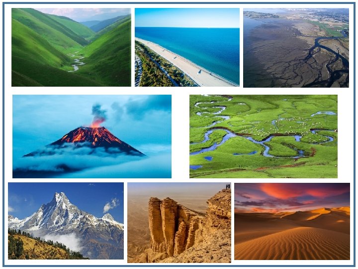
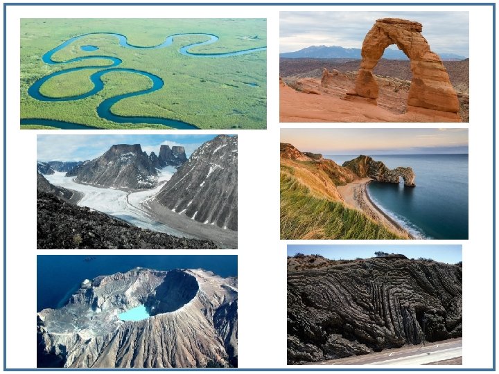
What do you see on the Earth’s Surface • We see various types of landforms on the Earths surface which includes mountains, hills, plateaus, plains, deserts, river valleys, river deltas, flood plains, cliffs, volcanoes etc. • Landforms are natural physical features of the Earth's surface. • Landforms are the most visible features of the Earth and occur everywhere. • They range in size from molehills to mountains to major tectonic plates, and their ‘lifespans’ range from days to millions of years.
What is Geomorphology • The word Geomorphology derived from three Greek words: geo: "earth"; morph: "form"; and logos: "study"; is the study of landforms and the processes that create them. • Geomorphology is the science that studies the origin and development of landforms (such as hills, valleys, sand dunes, caves), and how those landforms combine to form landscapes. • Geomorphology is an important topic in the field of physical geography, geology, geodesy, engineering geology, archaeology and geotechnical engineering.
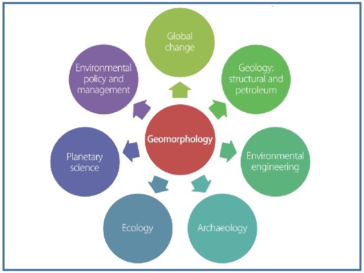
Applications of Geomorphology • In addition to explaining how landscapes have developed in the past, how they function at present, and how they might change in future, there is growing recognition of the importance of geomorphology and geomorphologists in contributing to a range of environmental investigations and management issues • For instance, structural geologists want to know how erosion at the Earth's surface influences patterns of rock deformation in developing mountain belts. • Petroleum geologists use the understanding of modern -day depositional processes to improve subsurface exploration efforts for oil and gas reserves hosted in sedimentary rocks.
Applications of Geomorphology • Engineers use knowledge of erosional and depositional processes to improve estimations of the thresholds of stability for hillslopes, or to assess the probability of channel changes along rivers where infrastructural developments are planned. • Planetary scientists apply insights gained from study of the Earth's landscape processes to help them interpret planetary surfaces. • Archaeologists are interested in how erosional and depositional processes influence the preservation of artefacts and other forms of evidence for past human societies.
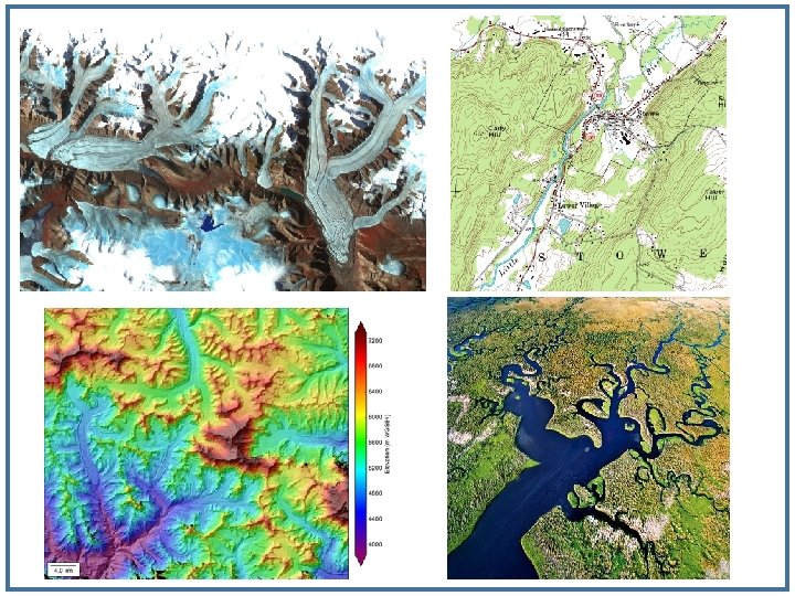
Tools for geomorphological studies • Traditionally, geomorphological study approaches focused mainly on field observation, description and measurement but also included physical experimentation (e. g. in small field plots or using laboratory flumes). • Since the early 1970 s, however, high-resolution images of the surface topography of the Earth and other planets have been acquired at rapid pace from a variety of satellites and spacecraft. • Many of these images are now readily available for free from the internet (e. g. using virtual globes such as Google Earth).
Tools for geomorphological studies • In addition, large numbers of computer-based topographic models (e. g. Digital Elevation Models) have become readily available, and ground-based monitoring, computational modelling, and geochronological (dating) techniques (e. g. luminescence, cosmogenic isotope analysis) have advanced rapidly. • Consequently, traditional geomorphological study approaches are now commonly combined with these new images, models and techniques to quantify rates and timescales of landform change. • It is now possible to view, measure, age, and model a variety of landforms and landscapes in ways that were unimaginable even a decade ago.
10 reasons why Geomorphology is important
10 reasons why Geomorphology is important
Landscapes are shaped by movements of mass • Landforms are shaped by geomorphological processes, which essentially involve the movement of mass ‒ rock, sediment, water ‒ across the Earth's surface. • Movement of mass commonly involves the weathering, erosion, transportation and deposition of surface materials by gravity, ice, wind, or water, but can also involve near-surface tectonic, volcanic or groundwater activity.
Landscape processes operate at many different scales • • Geomorphological processes are driven by endogenic • factors (powered from within the Earth such as volcanoes and earthquakes) and exogenic factors (powered by the sun's energy and working through the climate system, such as rain, wind and waves). • Different processes result in different rates for the movement of mass, from very slow (e. g. basin subsidence, soil creep) to extremely rapid (e. g. volcanic eruptions, rock falls) Landforms vary widely in spatial scale (size), and their development occurs across a wide range of temporal scales. Small scale landforms such as sand ripples form, erode and re-form on rapid temporal scales, while large scale landforms such as mountain ranges develop over far longer temporal scales
Scale and Age of Landforms • Scale of landforms varies over 15 orders of magnitude • Continents (107 km 2) to microscale features like ripples, glacial striations (10 -8 km 2) • Age of landforms varies over 7 -8 orders of magnitude • Continents (109 years) to microscale features like pools and riffles (102 years) • Larger landforms most durable (longer-lasting) • Smaller landforms created/destroyed faster than larger ones • Rates of geomorphic / geologic change slow for larger areas, • Faster when measured over small areas. example: earthquakes compared to glaciers • Rate of erosion in small watershed compared to larger one
Factors responsible for Landform Formation • William Morris Davis introduced idea that landforms can be explained by one or usually a combination of the following • Structure: rock mass (or unconsolidated material mass). • Process: constructive or destructive process(es) acting now or previously on structure. • Time (stage): landforms evolve through stages from continued actions of geomorphic process(es).
Structure Process Time Resulting Landform 17
Geomorphic Process • The formation and deformation of landforms on the surface of the earth are a continuous process which is due to the continuous influence of external and internal forces. • The internal and external forces causing stresses and chemical action on earth materials and bringing about changes in the configuration of the surface of the earth are known as geomorphic processes.
https: //youtu. be/8 ia. Xljs. MIt. Y
Geomorphic Process (Endogenic) • Endogenic forces are those internal forces which derive their strength from the earth’s interior and play a crucial role in shaping the earth crust. • Examples – mountain building forces, continent building forces, earthquakes, volcanism etc. • The endogenic forces are mainly land building forces. • The energy emanating from within the earth is the main force behind endogenic geomorphic processes. • This energy is mostly generated by radioactivity, rotational and tidal friction and primordial heat from the origin of the earth.
Geomorphic Process (Exogenic) • Exogenic forces are those forces which derive their strength from the earth’s exterior or are originated within the earth’s atmosphere. • Examples of forces – the wind, waves, water etc. • Examples of exogenic processes – weathering, mass movement, erosion, deposition. • Exogenic forces are mainly land wearing forces. • Exogenic forces can take the form of weathering, erosion, and deposition. • Weathering is the breaking of rocks on the earth’s surface by different agents like rivers, wind, sea waves and glaciers. • Erosion is the carrying of broken rocks from one place to another by natural agents like wind, water, and glaciers.
Brands of Geomorphology • The two complementary main brands of geomorphology are historical geomorphology and process geomorphology. • Historical geomorphology tends to focus around histories of land scape evolution and adopts a sequential, chronological view. • Process geomorphology tends to focus around the mechanics of geomorphic processes and process– response relationships (how geomorphic systems respond to disturbances).
Brands of Geomorphology • Historical geomorphology and process geomorphology are complementary and go hand-in -hand, so that historical geomorphologists consider process in their explanations of landform evolution while process geomorphologists may need to appreciate the history of the landforms they investigate.
Historical Geomorphology • Historical geomorphology is the study of landform evolution or changes in landforms over medium and long timescales, usually timescales well beyond the span of an individual human’s experience – centuries, millennia, millions and hundreds of millions of years. • It brings in the historical dimension of the subject and relies mainly on the form of the land surface and on the sedimentary record for its databases. • It relies on the principal: the present is the key to the past. • It means that the effect of geomorphic processes seen in action today may be used to infer the causes of assumed landscape changes in the past.
The Geomorphic/Geographic Cycle • The ‘geomorphic cycle/geographical cycle’, given by William Morris Davis, was the first modern theory of landscape evolution (e. g. Davis 1889, 1899, 1909). • Geomorphic processes, without further complications from tectonic movements, gradually wear down the raw topography. • Furthermore, slopes within landscapes decline through time : maximum slope angles gradually decrease. • So topography is reduced, little by little, to an extensive flat region close to base level – a peneplain.
The Geomorphic/Geographic Cycle • The reduction process creates a time sequence of landforms that progress through the stages of youth, maturity, and old age. • The ‘geographical cycle’ was designed to account for the development of humid temperate landforms produced by prolonged wearing down of uplifted rocks offering uniform resistance to erosion. • It was extended to other landforms, including arid landscapes, glacial landscapes, periglacial landscapes, to landforms produced by shore processes, and to karst landscapes.
The Geomorphic/Geographic Cycle
Process Geomorphology • Process geomorphology is the study of the processes responsible for landform development. • Three main contribution of process geomorphologists are: • A database of process rates in various parts of the globe (measurement of geomorphic process). • Highly refined models for predicting the short-term (and in some cases long-term) changes in landforms (modeling geomorphic process). • Ideas about stability and instability in geomorphic systems.
Other Branches of Geomorphology • Although process and historical studies dominate much modern geomorphological, other types of study exist. • For example, structural geomorphologists, argued that underlying geological structures are the key to understanding many landforms. • Today, other geomorphologies include applied geomorphology, tectonic geomorphology, submarine geomorphology, climatic geomorphology, and planetary geomorphology.