Unconformities Three types of unconformities Disconformity Nonconformity Angular


.")
.")
.")
")
")


 (-50, 30)")

![Apparent dip angle = arctan [sin(φ-θ ). tan(dip)]](https://slidetodoc.com/presentation_image_h2/484d90f1632f5651f198454ccf03f4b4/image-21.jpg "Apparent dip angle = arctan [sin(φ-θ ). tan(dip)]")


![Strike: [-180, 180] or [0, 360] Dip: [0, 90] Rake : [-180, 180] or](https://slidetodoc.com/presentation_image_h2/484d90f1632f5651f198454ccf03f4b4/image-24.jpg "Strike: [-180, 180] or [0, 360] Dip: [0, 90] Rake : [-180, 180] or")
- Slides: 27
Unconformities Three types of unconformities: - Disconformity - Non-conformity - Angular unconformity
Unconformities signify gaps in the sedimentation record due to a period of erosion
Schematic representation of the three kinds of unconformities: • nonconformity • angular unconformity • disconformity. http: //www. falw. vu/~rondeel/maps/discordanties/discos. htm
http: //mountaincatgeology. wordpress. com/2009/02/16/unconformities/ A most famous angular unconformity is in the Grand Canyon where the a Cambrian Sandstone unit overlies a Proterozoic sedimentary unit.
• Video: Origin of Grand Canyon layers: sandbox demonstration - Created by Steve Kidder; edited and music by Tim Pyle (IPAC)
JP Avouac Angular unconformity between fluvial gravel and Lower Siwalik sandstone and mudstone beds along the Bagmati river (Nepal).
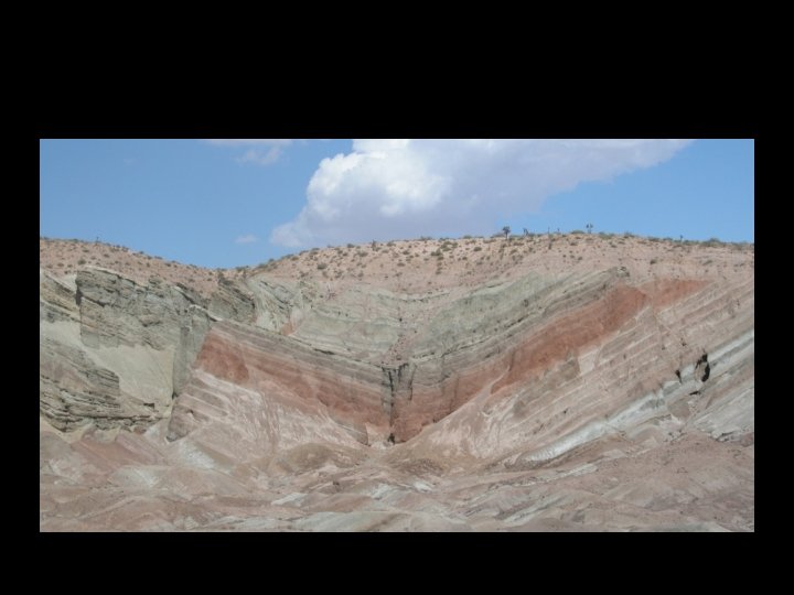
N S N JP Avouac East looking view of northern limb of Anjihai anticline (north Tianshan Piedmont). The Pleistocene gravel layers in (fanglomerates) the foreground are unconformable over Late Miocene sandstone strata which are dipping by about 30 to the North. What is the story? - The sandstone units were deposited first (as initially ‘sub-horizontal’ layers), then tilted, then eroded. - The gravel layers were deposited as sub-horizontal layers over the erosion surface cut into the sandstone leading to a angular unconformity. - Any indication that titling accrued after that? What about uplift? Relative to what? - Can you tell how much titling occurred before and after depostion of the Pleistocene gravel?
South Tian Shan Piedmomt, near Kuqa (Hubert-Ferrari et al, JGR, 2007; Daeron et al, JGR, 2007) This unconformity is clearly visible in satellite images
JP Avouac West looking view of southern limb of Kuqa anticline (south Tianshan piedmont). (See study by Hubert-Ferrari et al , JGR, 2007). An interesting lateral transition from a clear-cut angular unconformity to a progressive angular unconformity.
JP Avouac East looking view of southern limb of Kuqa anticline (south Tianshan piedmont).
JP Avouac East looking view of southern limb of Kuqa anticline (south Tianshan piedmont).
(Hubert-Ferrari et al, JGR, 2007)
JP Avouac West looking view of the core of Qiulitage Anticline (south Tianshan Piemont)
Field measurements • Preparation to field work • Field observations prior to any structural measurements • Measurements at the outcrop scale • Measurements on maps
Orientation of structures. • In structural geology we complement information about the rock units outcropping at a location (x, y, z) with information about the orientation of surfaces or curves passing through that point of observation. These surfaces and curves can be approximated by their tangential plane, or line respectively. – Planes (bedding plane, foliation, fault plane, …) – Lines (fault striation, intersection lineation, stretching lineation, fold hinge line, …)
Orientation of structures. • These measurement are essential to allow the kind of interpolation and extrapolation needed to produce a map or construct a cross section. • There are standard ways of characterizing these geometries and representing them on maps and sections.
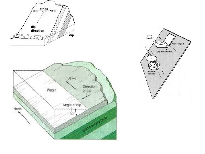
Orientation of planes The orientation of a plane can be defined from 1. its strike and dip angles (most common usage); 2. its dip direction: vector with azimuth perpendicular to strike and plunge equal to the dip angle; 3. its ‘pole’: the vector normal to the plane (with azimuth perpendicular to strike and plunge equal to <90°-dip>). (useful for data processing)
Orientation of planes 1. The strike is always measured with respect to North. (generally positive clockwise then label ‘E’ for eastwards from north; ‘W’ if counterclockwise). 2. The dip (the ‘slope’ of the plane) is always measured positive downward. For a given strike there are two planes with the same dip angle. You need to indicate in which quadrant lies the dip direction or use a right-hand convention (dip to the right if you look in the strike direction). Be sure your measurements are not ambiguous.
N 50 W, 30 NE N 310 E, 30 NE (310, 30) (-50, 30) With the right-hand convention that the plane dips to the right of the strike azimuth (NB: according to trigonometric usage angles are measured positive CCW)
50 W, 30 NE N 310 E, 30 NE 310, 30 N 130 E, 30 NE
Apparent dip angle = arctan [sin(φ-θ ). tan(dip)]
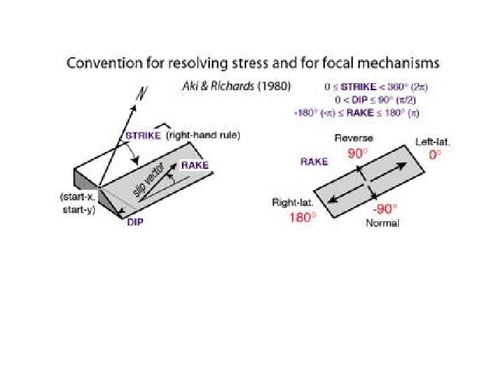
Orientation of lines The orientation of a line can be defined from 1. the strike and dip angle of a plane to which the line belongs, and pitch (or rake )(any intersection lineation, stretching lineation on the foliation plane, striation on a fault plane) 2. the azimuth of the vertical plane containing the line and the plunge , the angles it makes with respect to horizontal.
Orientation of lines The orientation of a line can be defined from 1. the azimuth (or bearing) of the vertical plane containing the line and the plunge (positive downward). 2. the strike and dip angle of a plane to which the line belongs, and pitch (measured downward in general) or rake. If the line features an oriented marker of deformation, the convention is to represent the sense of motion of the hangingwall with respect to the footwall
Strike: [-180, 180] or [0, 360] Dip: [0, 90] Rake : [-180, 180] or [0, 360] • In seismotectonic the strike is the direction such that the fault dips to the right (right hand convention). • The rake is measured positive CCW relative to the strike direction and describes the motion of the hanging wall relative to the footwall. – Strike-Slip fault : rake=0 (left-lateral) rake=180 (right lateral) – Thrust fault : rake= 90 – Normal fault : rake=- 90