The complete history of South Marston darren cookhenryandco


 referred to in people’s")


 including 20 shillings to his servant Edmund")


- Slides: 42
The complete history of South Marston darren. cook@henryandco. uk
Sources • Books – Roman Wanborough, Highworth Hundred, Tax Lists, Inquisitions PM, Alfred Williams • Maps – early county maps, 1773 Andrews & Dury, 1840 Tithe Map, 1886 Ordnance Survey, 1918 Auction • National Archives & Wiltshire & Swindon History Centre – over 500 deeds, leases, wills, 1840 Tithe Records • Parish Records – baptisms, marriages & burials 1539 -1840 & onwards • Census Records – 1801 onwards • Archaeological records – Wiltshire Sites & Monuments Record, Archaeological Data Services, WANHS Magazine • National Monuments Record - aerial photographs • Google Earth • British Museum – pottery collection • Field-walking – fossils, pottery & coins • Landscape analysis – numerous text books • Buildings – SBC Listings Record & past buildings in the village • Internet – British History Online & Census (e. g. Freecen 1861)
Dinosaurs • 4. 6 metres, each mm one million years • repeated ages of desert, jungle, sea, ice • prehistoric sea - fossils of 500 million year old coral & 200 million year old ammonites, belemnites & bivalves • did dinosaurs exist 100 million years ago in South Marston’s Kimmeridge Clay?
Geology Ridgeway Highworth South Marston chalk alluvium clay Kimmeridge clay green sand coral limestone
Prehistoric man • 40, 000 years ago – Neanderthals? • 10, 000 – end of the Ice Age & hunter-gatherers appear along the Ridgeway? • 6, 000 - neolithic farming – SM stone axe • 4, 500 – Bronze Age civilisation – ritual & worship – SM round barrow • 2, 500 – Iron Age society – Atrebates & Dobunni, forts, pottery, burials
Neolithic stone axe from South Marston
A man-made landscape SM
Roman 43 - 410 • Ermin Street, Cunetio, mansio & Cirencester • Durocornovium population more than 3, 000 - a society that flourished for 350 years but no written record • Romano-British farming estates (c. 1800 acres) • Villas at Bishopstone & Stanton Fitzwarren – how about Earls Court & Rowborough? • S Marston road, villa, pottery, coins, SM Park burials
Roman villas in the area? Stanton Fitzwarren Rowborough ? Earls Court ? Bishopstone
South Marston’s Roman Road? Durocornovium
AD 500 Saxon Influence • AD 410 Roman administrators & soldiers leave to defend Rome from Germanic tribes • towns & economy decay - Durocornovium • towns people disperse as Saxons raid & settle in kin-based rural farms • Saxons & Britons eventually live together • Saxon charters but no written record for SM
AD 700 dispersed farms, marsh & forest (1280 names ley, ledenhull, leighmannesheys & field shapes) & north-south road to Lotmead Roman junction?
AD 900 King Alfred’s burh, security & collectivism sees arable replacing forest & nucleated village: Mersh Tun
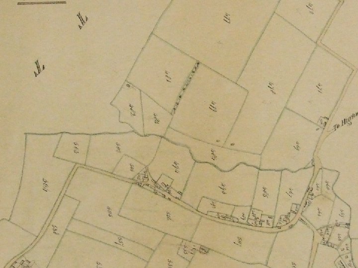
Mersch tun – Merston • where was the marsh? The entire central area is below 95 m & Longleaze below 90 m - see Google Earth next • consider sub-soil – clay & greensand interspersed to give dispersed marsh (e. g. West Marsh & Long Marsh to the west) • consider changing climate & water table
Longleaze Farm & Great Marsh, then channels - drainage of the marsh or water meadows & cattle ponds? Do the channels pre-date the enclosed fields of 1600? l h e ot
The Feudal System • Saxon Shires divided into Hundreds of 100 tuns Highworth Hundred: Coleshill to Castle Eaton & Haydon Wick to South Marston – 30 villages by 1300 • Hundreds divided into Manors held by a lord - demesne, chapel, reeve, court & bailiff, tithingman, free tenant, villein, cottar; customary tenancies (later copyhold), rents, fines & services; nucleation & open-field system to share oxen, ploughing, good & bad soil, haymaking & harvests, in allocated ridge & furrow strips & common pasture & meadow; virgate (30) & demi-virgate (15); grain subsistence for beer, bread & pottage & animal products (wool & cheese) for market – Sainsbury’s! • Norman & Monastic exploitation of Saxon system
Royal Merston • 1086 Domesday Book omission – Saxon Royal Manor of Sevenhampton? • 1150 Queen Matilda gave an estate in Merston to the Priory of Farley • 1150 construction of the church of Mary Magdalene • 1200 -1350 Kings’ itineraries Marlborough & Lechlade (London, York, Marlborough, Leicester) • 1276 Sevenhampton Manor reverts to the Crown
AD 1200 Priory of Farley planned village, less wood & marsh, new church, road alignment, Berton & Wick East Field West Field
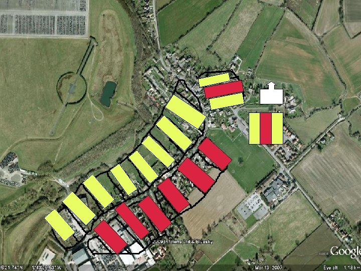
Medieval 1280 • 141 Merston villagers named in Manorial Court Records from 1271 -88 & comparison with Sevenhampton (70 houses) indicates: • estimated 300 people in 60 houses – the highest population until 1831 (339)! • some houses at Berton (10), Wick (10) & one or two farmsteads (Chelesies, Wydie, Ley? ) but majority in Merston (40) in toft & croft plots 30 m x 100 m, wattle, daub & thatched houses
1280 villagers named • Merston: 96 inc. 44 from the families of Thomas Warde, Richard Faber (Smith), William Yrmongar, Robert le Messor [hayward], Simon Cowherd, Walter Molendinarius [windmill? ], Robert Godchep, Jacob Renfrey, Stephen Poynant, Henry Le Bedel, Hugo Abbod, Thomas Felawe, Walter Url & Everard the chaplain…. • Berton: 21 inc. 15 from the families of William de Berton, Robert de Abendon, Hugo Stone [quarry] & Walter Hyldyth [hill ditch]… • Wick: 14 inc. Richard de Wyk (chaplain & steward of the Priory), other “de Wyks” Thomas, Nicholas, Andrew, Robert & Walter Sculhard & family, Agnes, William, Robert & Margery & “the brewers of the priory”… • Out-lying farms? inc. 10 from Johannes de la Leye, Richard de Marisco, Robert de Wydie (& Cheles ? )
1280 tracks • primary routes north-south Berton & Highworth to Wick & Ermin Street & east-west Sevenhampton Court to Stratton Market • Dark Lane to waddebroke & brokforlonge? • Green Lane to Bradymoor & Heldichesham • Pathlay to Ley Farm ? Leighmannesheys, Ledenhull, Berefurlong • (Nightingale) lane to Chelsiesmede – Chels’ Farm? • drove to north of Chelsiesmede • diagonal holloway to Priors Farley, Hackerne Bridge & Bourton • Rowborough Lane (1629) to Wydie (Great Rowborough)? • de Marisco Old Vicarage Lane drove – A 420 & O V Lane roads post-1700?
1280 tracks? No canal, railway, A 420; alternative Bourton & Lotmead routes; Dark Lane, Green Lane, Path Lay, Chelesies Drove marsh
Chelesies Drove pre-1200
1315 flooding • land use at full stretch to feed 5 million (building oak from Savernake in 1280 indicates reduced woodland) • “the chronicles describe the famine in biblical terms: rains fell nearly continuously for three years …. crops rotted & many people died of starvation or disease” • sheep murain & cattle rinderpest creates the Great Famine 1315 -21, killing 10% of the population • Did it happen here? Are we flooded every century? • Alfred Williams recalled freak weather: the ruination of Farmer Wheeler at Rowborough Farm “excessive rains came and the floods washed the whole of it away and left him penniless” & in the severe frosts of 1891 the canal was frozen for seven weeks.
1332 Tax List • tax of moveable goods of wealthier villagers • Merston is wealthy - good pasture & meadow for animal products (second in the Hundred only to Hannington & same in 1334) • familiar names from 1280: de Abyndone, atte Stone (Berton), atte Wyke & Scolarde (Wick), de Marisco, atte Leghe, atte Wydie & also Le Revehyne (Reeve for absent Priory? )
Black Death 1349 • killed 2 million of a population of 5 million in just two years (compare WWI dead 1 million of 35 million in four years) • 1377 tax record suggests 145 people died in Merston & 155 remained – did it destroy Wick? • where are they buried? • the Black Death recurred four times to 1380 & destroyed communities, religious orders, manors & the feudal system • many copyhold life tenancies were replaced by 7 year leases!
145 skeletons in South Marston?
1365 allocation • Thomas Pykote, wife Alice & son Robert rent a messuage with toft & croft between William le Cartere to the west & Andrew le Heywarde to the east [planned plots] for their lives for 6 shillings yearly, pasture for 3 oxen in the woodland & 8 acres of arable: • one acre in leighmannesheys, trokenbergh, benhull & rywardeslade • half an acre in longforlong, lowstede, stokforlonge, ledenhull & lithesmore • one & a half acres in waddebroke • illustrates copyhold landholding – about to change!
Winchester College & Leyplace • Lay or Ley (“wood clearing”) referred to in people’s names & field names 1230, 1280, 1332 • 1391 Winchester College acquires Leyplace comprising c. 60 acres (spread out in common fields) • 1393 to 1596: eight leases for terms between 7 & 40 years, rather than lifetime copyholds, with the rent decreasing from 23 shillings to 20 shows reduced population meant reduced demand for arable • WC land allocation becomes enclosed in 1640 & is centred on Pathlay, later Pidgeonhouse Farm
The missing 1400 s • few manorial, court, tax records or deeds have been published for South Marston - historical fracture in “surnames” (no more Poynant, Godchep, Wyk, Marisco, Ley, Wydie, Berton, Hyldyth etc) • 1380 -1480 golden age of wool, cloth & aristocratic magnets - Hungerfords (courtiers to the kings) had stewardship of the Priory of Farley & acquired land for themselves throughout Wiltshire, including South Marston & perhaps paid for the church tower c. 1440? • Hungerfords’ relatives from 1500 include intermarrying Wanborough/Stratton/Stanton/SM families of Brind, Cusse, Burges, Bryant & Harris & it is they who comprise SM tax payers in 1545 & 1576
Elizabethan Mansion • Manor Farm – Henry Hungerford 1576 -82 “my lower house” • Berton “Manor” – Henry Hungerford junior until 1626. • Wynnings in Leycrofte, “mansion” built by the Harris family? • Old Farm - William Brind, “the farmer of Marston” died 1577 • Cusses Place - once de Marisco? now Longleaze Farm? • Rowborough – Burgess family • Bennett’s & Beck’s & Dorothie Mundaie’s • Population 150 – 30 families Jenckins, Pinching, Edne, Grundie, Mundy, Stevens, Tayler, Lewis, Drue, Fowler, Davis, Smarte
1600 Will of Hercules Burges (1565 -1617) including 20 shillings to his servant Edmund James (1581 -1658) both in Parish Records
Family Histories • Parish Records from 1539 & WSHC 120 wills, 500 leases & deeds name the villagers • the Parish Records contain family histories for the Southbys (1670 -1832), the Mundays (1569 -1824) & the Kempsters (1687 -1840) • frequent internet enquiries from people compiling histories of Elizabethan Hungerford, Brind, Cusse & Burges & more recent villagers from the Victorian era • we have one villager who can trace her history back to 1600 – inc. Jackie Bridges’ cottage Nightingale Lane
Village hierarchy • Before 1500: classed according to type of landholding in the manor: cottar, villein, freeman, lord • After 1500: classed according to monetary wealth: husbandsman, yeoman, gentleman, squire – no “agricultural labourer” • After 1600: Enclosure, at first, creates many self -sufficient husbandsmen & yeomen farming copyhold or leasehold land of 5 to 50 acres.
1650 Enclosure & Sale • Enclosure of the common fields started with the Hungerfords in the 1400 s & was complete by 1650 • we can trace ownership of most of the parish back to 1650 • enclosed land was more valuable, the Hungerfords “gambled their wealth” at the Court of King Charles I & sold two-thirds of the Parish by 1650: central manor & Old Farm to John Southby (JP, MP, Encloures Commissioner) who rebuilt the manor house (Manor Farm) Berton (Burton Grove Farm) to the Dowe family SM Farm, Longleaze & Dorothie Munday’s to James family?
1700 s chalk & cheese • North Wiltshire Cheese boom & the Marlborough factors selling to London, new A 420 turnpike road & Old Vicarage Lane post-1700 & 1600 acres of pasture by 1840! • landed gentry of Southby, Dowe, James & Goddards joined by Hippisley, Freke & Warneford: rents increase, farms renovated & new ones built (most of those we see today) • yeomen farmers pay higher rents for farms of more than 100 acres & displace many self-sufficient husbandsmen who now become landless employees, the agricultural labourers
The worn out agricultural labourer • 1801 Census: 151 agricultural workers out of c. 190 adults in 252 population (only the gentry 3% vote) • canal, railway, industrial & agricultural revolutions alter appearance of village & way of life • Alfred Bell’s brick & slate villas with allotments replace stone, wattle & daub, thatch & meadow • 1840 Tithe Map, Censuses & 1918 Auction name people & their houses & trace change • Alfred Williams & Nelus – farming, “medieval” harvesthome feast, soldiers, railway factory • 20 th Century owner-occupation of freehold land in small house plots (320 in SM, Sevenhampton 40) • farm land becomes recreational countryside (C Forest)
Our landscape shows us • field shapes & names evidencing 1, 000 years of reclamation, occupation, ownership & Enclosure, traceable in deeds • the central channels – drainage or irrigation? • road development at expense of field tracks • features - medieval holloways, platforms, headland, wells, ponds & Parish boundaries
Our archaeology may show us • dinosaurs • a Roman villa estate & dispersed Saxon farms • our lost roads (Roman Rowborough & Lotmead N-S) • the medieval planned village, manor & windmill • burials of plague victims & the death of Wick • the remains of Wynnings, the Elizabethan mansion
New development How important to you is the preservation of our landscape & archaeology?