MONTHLY CLIMATE REVIEW MARCH 2014 500 h Pa
")
![CONTENTS *Tropics -ENSO [Neutral] -MJO *Extra-tropics (& Sea Ice) *Verification of JFM & March](https://slidetodoc.com/presentation_image_h2/677b66e03d5edae0846a1032d113cec1/image-2.jpg "CONTENTS *Tropics -ENSO [Neutral] -MJO *Extra-tropics (& Sea Ice) *Verification of JFM & March")


")

 - MJO remains active with E. P. * entering")
 MJO strengthens Faster propagation speeds – atmo")
 MJO Forecast Yellow Lines – 20 Individual Members Green Line –")
")


 March 1 (record high)* *Weekly Weather & Crop")
; ITCZ previous: 8. 40” (1950)* E. P.")
")
 Dry start followed by trade wind strengthening Total PNP (%")


 Java")


- Slides: 42
MONTHLY CLIMATE REVIEW MARCH 2014 500 -h. Pa Cyclone Hellen (Mozambique Channel)
CONTENTS *Tropics -ENSO [Neutral] -MJO *Extra-tropics (& Sea Ice) *Verification of JFM & March 2014 Outlooks *Drought *Selected Weather Events *Outlooks (April & AMJ 2014 & MDO)
I. The Tropics
LATEST MONTHLY INDICES
LATEST MONTHLY INDICES
850 -h. Pa Wind H
850 -h. Pa Wind Recent Westerlies, esp. mid-month
200 -h. Pa Wind H H H
SST & Anomalies Subsurface
SSTA Predictions for Nino 3. 4 Region NMME & inputs CFSv 2 (6 th) CPC/IRI CPC Consolidation
OLR & Anomalies
MJO (March 17, 31 Overviews) - MJO remains active with E. P. * entering Indian Ocean; though indicators are increasingly incoherent due to destructive interference with slowly evolving atmospheric and oceanic conditions in western Pacific. - Dynamical model MJO index forecasts diverge considerably for next 2 weeks. Some models weaken MJO as it interacts with the low frequency base state, while others indicate a more robust Indian Ocean MJO event. - Statistical models generally favor continued MJO activity. - MJO favors enhanced (suppressed) convection over western & central Indian Ocean (Maritime Continent and western Pacific) during period; also tending to oppose ongoing convection across the west-central Pacific associated with increasing ocean temperatures. *E. P. = Enhanced Phase
200 -h. Pa Velocity Potential Anomalies (5°S-5°N) MJO strengthens Faster propagation speeds – atmo Kelvin waves? Slower propagation speeds Little propagation? Longitude Positive anomalies (brown shading) indicate unfavorable conditions for precipitation Negative anomalies (green shading) indicate favorable conditions for precipitation Indo. Pacific warm pool region
Ensemble GFS (GEFS) MJO Forecast Yellow Lines – 20 Individual Members Green Line – Ensemble Mean RMM 1 and RMM 2 values for the most recent 40 days and forecasts from the ensemble Global Forecast System (GEFS) for the next 15 days light gray shading: 90% of forecasts dark gray shading: 50% of forecasts The ensemble GFS forecast indicates no additional eastward propagation of the MJO signal.
II. The Extra-Tropics (and Sea Ice)
Northern Hemisphere 500 -h. Pa SLP
Southern Hemisphere 500 -h. Pa SLP
Global Temperatures King Salmon (52 F) March 1 (record high)* *Weekly Weather & Crop Bulletin (April 8)
Global Precipitation Seattle record: 9. 44” (254%); ITCZ previous: 8. 40” (1950)* E. P. S. P. MJO *Weekly Weather & Crop Bulletin (April 8) E. P. = Enhanced Phase S. P. = Suppressed Phase
Precipitation Featureless Departures clearly related to orography (much more so than PNP)
Hawaiian Rainfall (March 2014) Dry start followed by trade wind strengthening Total PNP (% of normal) + 1. 9” 4. 0” 54 3. 4” 3. 8” 92 18. 7” +: 6. 46” (March 8 -9) Oahu Forest Nat’l Wildlife Refuge Weekly Weather & Crop Bulletin (April 8) M 160 ~135
Sea Ice Arctic Antarctic *Annual maximum extent on March 21 *Annual minimum extent on February 23 2014 Arctic max is 5 th lowest in record (1978 -2014) 2014 Antarctic min is 4 th highest in record (1978 -2014) L -2 https: //nsidc. org/arcticseaicenews/ -1
Significant increase in coverage of multi-year ice https: //nsidc. org/arcticseaicenews/ http: //projects. kmi. open. ac. uk/role/moodle/pluginfile. php/712/ mod_page/content/1/u 116_2_f 004 i. jpg
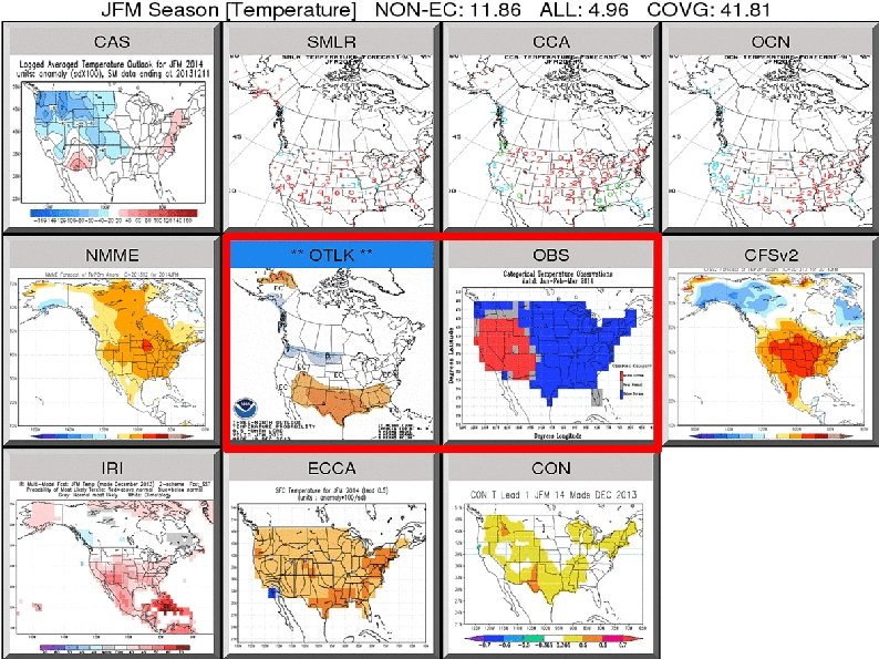
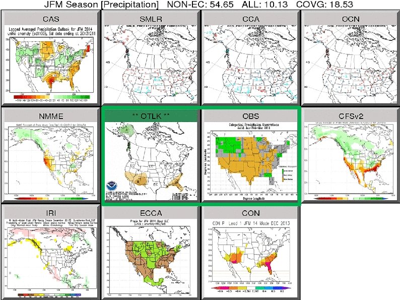
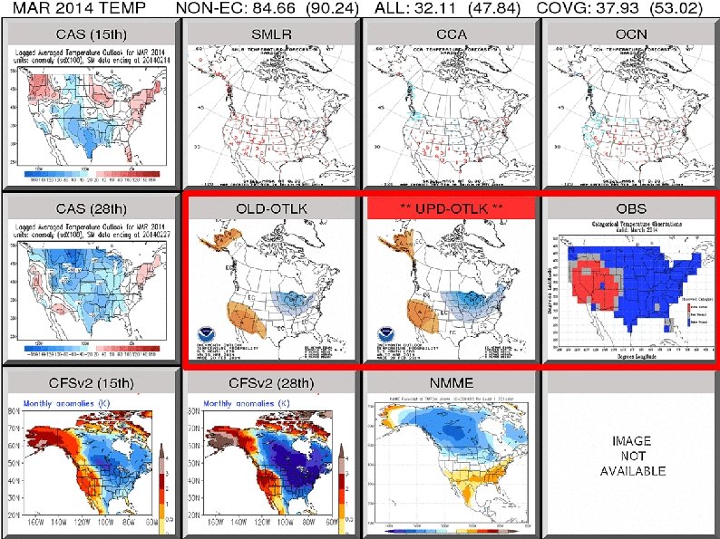
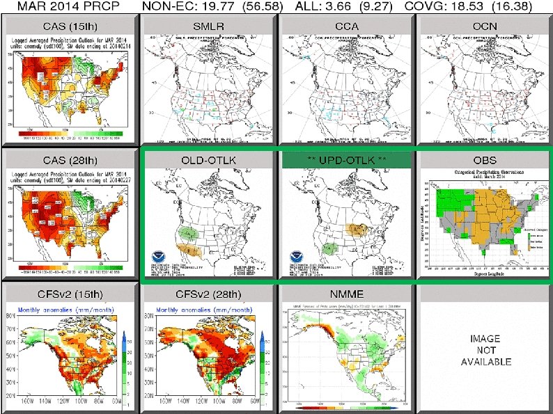
III. Verification of JFM & March 2014 Outlooks
IV. Drought
DROUGHT MONITOR March 4 April 1* * Okay, so data cutoff extends 8 hours into April (12 z April 1 st) !
http: //www. wcc. nrcs. usda. gov/ftpref/support/water/westwide/snowpack/wy 2014/snow 1404. gif
Monthly-Average Stream flow for the month of year Soil Moisture Anomaly CPC NLDAS
V. Selected Weather Events
Track of Cyclone Gillian Sumatra March 6 -26, 2014 10 -min winds: 125 mph 1 -min winds: 160 mph Highest Gusts: 180 mph Minimum SLP: 937 h. Pa Borneo Java X PNG Bali E. Timor Christmas Island Gillian also affected search for missing Malaysian Airlines Flight 370 http: //upload. wikimedia. org/wikipedia/commons/7/74/Gillian_2014_track. png
Gillian “X” Approximate location of Christmas Island (10. 5 S, 105. 6 E) Java X http: //upload. wikimedia. org/wikipedia/commons/thumb/0/00/Gillian_Mar_23_2014_0645 Z. jpg/459 px-Gillian_Mar_23_2014_0645 Z. jpg
Track of Cyclone Hellen Tanzania March 27 -April 1, 2014 10 -min winds: 145 mph 1 -min winds: 155 mph Minimum SLP: 925 -h. Pa Mozambique Madagascar http: //en. wikipedia. org/wiki/File: Hellen_2014_track. png
Explosive Deepening of Cyclone Hellen over the Mozambique Channel Symmetrical & Intense CDO (150 miles) Eye: 12 mi http: //upload. wikimedia. org/wikipedia/commons/thumb/1/1 e/Hellen_Mar_30_2014_0720 Z. jpg/515 px-Hellen_Mar_30_2014_0720 Z. jpg
Hazel Landslide/Oso Mudslide in Washington state March 22, 2014 ACIS {1500 feet long, 4400 feet wide and 30 -40 feet deep} Washington State Patrol http: //en. wikipedia. org/wiki/File: Oso_landslide_%28 WSP%29. png
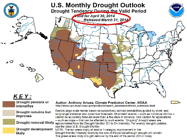
VI. Outlooks for April & AMJ 2014 & MDO
APRIL TEMP APRIL PRCP AMJ TEMP AMJ PRCP
THE END ? ? ! http: //roflmouse. com/wp-content/uploads/2010/08/funny-animal-pictures-cute-duckling-scam. jpg