HYDROLOGY Lecture 9 Surface Flow ASSOC PROF DR


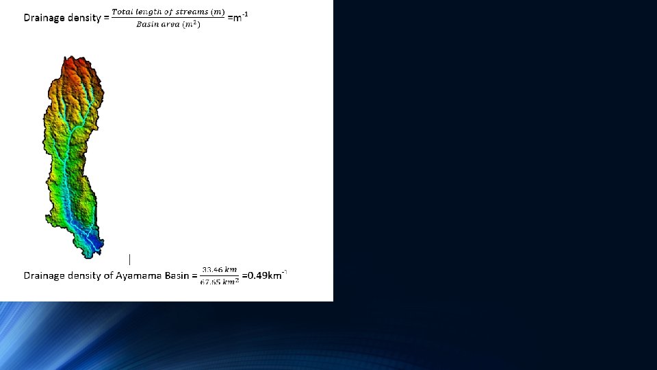
 Outlet (Ayamama Basin)")


 Gravelius coefficient")


 density: ratio of total number of tributaries")


 – the same) and (chronos")

 is required time for water drops to reach outlet 3∆t is")


. Newly fallen clean snow")

 25 Q=Ci. A 20 15 10")
- Slides: 34
HYDROLOGY Lecture 9 Surface Flow ASSOC. PROF. DR. TARK AN ERDIK
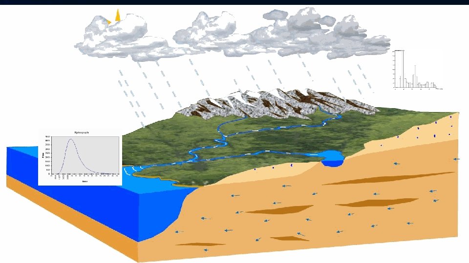
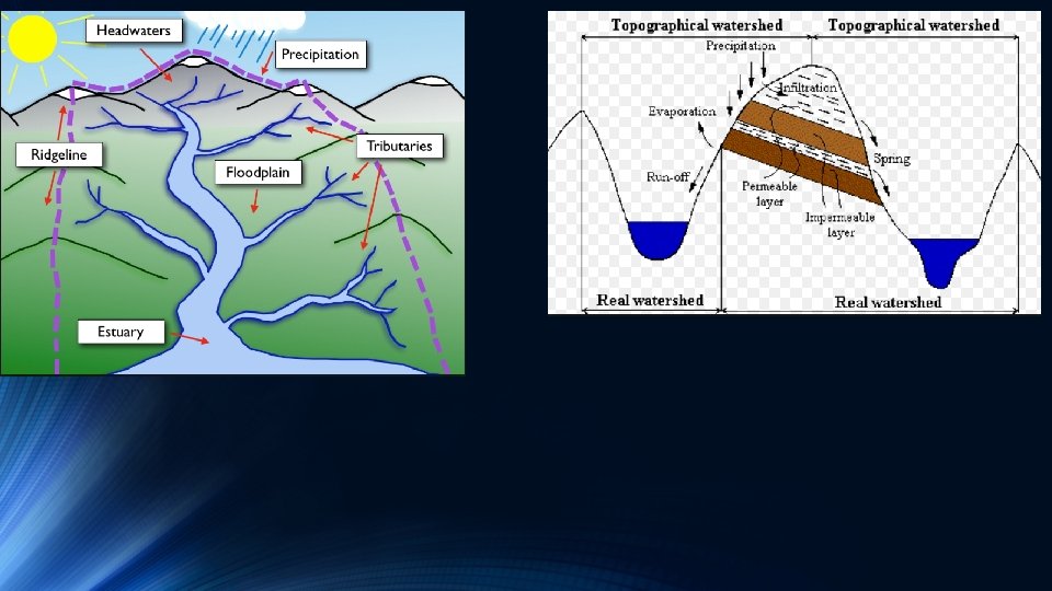
RIVER BASINS River basin/catchment area/drainage area: The surface which transmits water to the outlet point an a stream. A system which transforms the precipitation falling on it to the outlet point.
A water division line separates a basin from neighbouring basins. This line coincide with the topographic line. It starts with the outlet point and follow the highest point in the area. The water division line connects the highest points in the area. The water flows down to the lowest point, outlet.
Ayamama Basin Tavukçu basin Division line Outlet (Tavukçu Basin) Outlet (Ayamama Basin)
3 D View of Ayamama Basin The Highest elevation of the basin. Division line Outlet (Ayamama Basin): The lowest elevation of the basin.
Characteristics of River Basins 1 - Type of soil and geologic structure: They effect the mophologic properties and infiltration of flow and groundwater. 2 -Vegetal cover: determines traspiration and interception losses, effects the amount of surface flow, melting of ice. It may have a significant effect on infiltration 3 -Basin size: expresses the area of basin. For small basins, the maximum dishcarge per unit area is larger, the distribution of flow within the year is irregular.
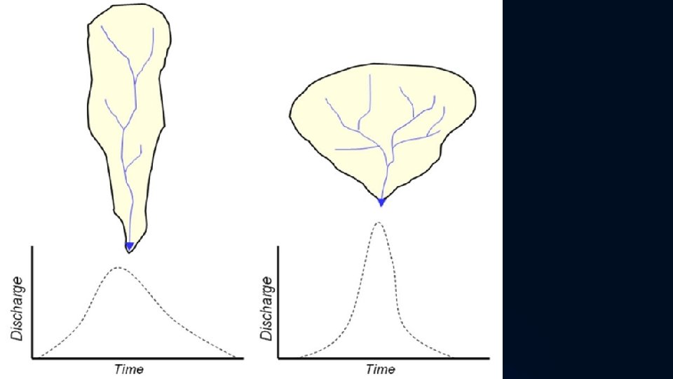
4 -Basin shape: effects the shape of the hydrograph and peak discharge. Various dimensionless quantities are used a) Shape coefficient : L 2/A where L=main stream length, A=basin area
b) Gravelius coefficient
A=6 km 2 P=10 km a=2 km b= 3 km
5 - Basin slope
Characteristics of River Basins 1 -River (stream) density: ratio of total number of tributaries to basin area 2 -Drainage density: ratio of total length of all streams to basin area. Has a value of 0. 5 -2. 5 km/km 2. If drainage density is high, intensity of flood increase.
3 -River profile: The line which shows the variation of the thalweg elevation of main stream with respect to distance from outlet. The slope usually increases further away from the outlet. The slope is of the order of hundreds in mountainous regions while it is of the order of thousands or ten thousands in the plain streams.
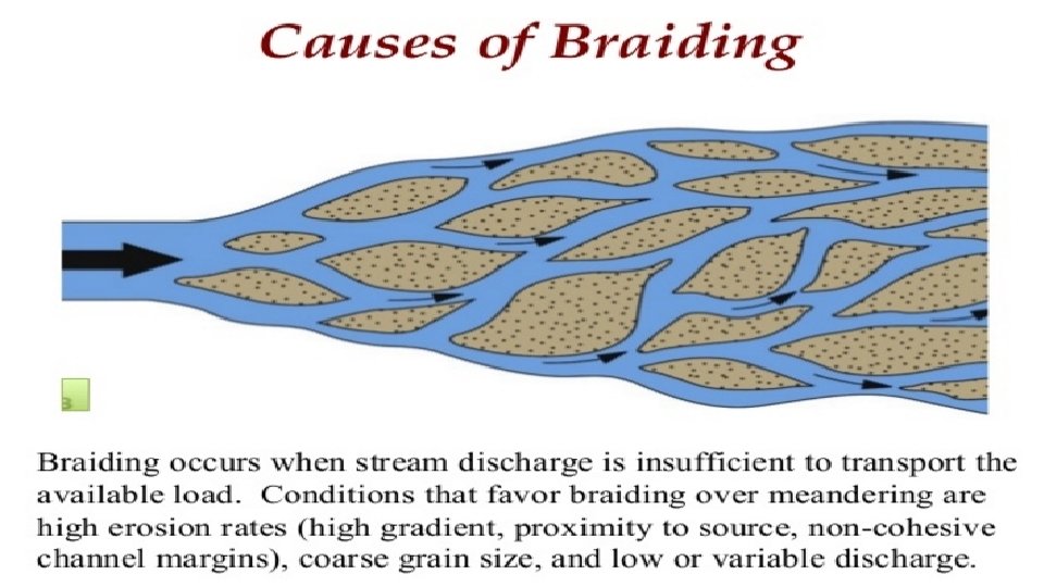
4 - The shape of river network: Various shapes exist depending on geologic structure. There are no rivers following a straight line in nature. Meandering or braided. (a) Meandering river system (b) Braided river system
5 - Stream order: 1 - Give number 1 to the most exterior links 1 1 2 3 4 2 - Search V shaped links and start with them 1 1 2 1 1 6 1 7 2 9 3 - Continue until you reach outlet
6 -The cross-section of river: Cross sections are usually irregular but the main part can be approximated by a trapezoid. The depth and width generally increases in the direction of the flow.
3. Concentration time: Time needed for surface flow to travel from the furthest upstream point to the outlet Furthest point Blue line: stream Yellow line: The longest distance from outlet to the furthest point Outlet
Time of concentration is sum of 1 -Time needed for precipitation intensity to exceed infiltration capacity. 2 -Time needed for surface storages to fill 3 -Time needed for the flow in the form of layer to arrive at the river network 4 - Time need to arrive at the outlet along the river network. Tc=K An/Sm A T S T Tc=0. 066 (L 2/S)0. 385 T=hours, L=stream length in km, S=slope Tc=6. 12 (Ln)0. 6/(i 0. 4 S 0. 3) T= in minutes, L=in m, i=intensity mm/h, n= manning coefficient
Specific discharge: It is the ratio between discharge at the outlet and basin area (m 3/s-km 2). Flow depth: It is the ratio between flow volume and basin area. Example: Please calculate the flow depth when total flow volume is 1000 m 3 and basin area is 1 km 2. Flow depth: 103/106=10 -3 m Flow coefficient: It is the ratio between flow depth and precipitation depth. It is a dimensionless coefficient. It is between 0. 05 -0. 50. Question: Is it possible to have flow coefficient over 1?
Runoff Separation Flow Surface Flow Subsurface Flow Groundwater Flow Subsurface flow takes place in unsaturated zone and returns to surface. Groundwate takes place in saturated zone
Flow is divided into two parts. Total Flow Direct runoff (Surface flow + undelayed subsurface flow) Base flow (Groundwater flow + delayed subsurface flow) Undelayed subsurface flow reaches river shortly however it needs long time for the delayed flow to reach the river.
Direct flow is the main source of floods. Baseflow is important for feeding rivers in dry periods.
Isochrone The word isochrone is of Greek derivation (iso(s) – the same) and (chronos - time). The black circle in the figure describes the circular boundary which takes 5 min to reach Christ Church. In short, the line connects points of equal travel time.
7∆t (or Tc) is required time for water drops to reach outlet 3∆t is required time for water drops to reach outlet 2∆t is required time for water drops to reach outlet
Rational method The maximum streamflow estimation is needed in the design of hydraulic structures. Q=Ci. A, where C: discharge coeffcient (-), i: rainfall intensity (m/s), A: m 2. Therefore, Q=m 3/s. Precipitation intensity can be calculated or obtained from the IDF curves. C expresses the infiltration rate and other losses, and higly depends on permeability of soil. Rational method should not be used in large basins. It gives good result when the percantage of the impervious layer in the basin is high. Rational method should be used with care for basins larger than 0. 5 km 2.
Runoff due to snowmelt Precipitation falling as snow might stay on the ground surface for a long time and becomes runoff only when it melts in warm weather. The heat that is necessary for melting of 1 gr of ice is 80 cal. There are various sources to provide energy
1 -Radiation from the sun: Mainly depends on reflection (albedo). Newly fallen clean snow reflects 80 -90% of the heat whereas old and dirty snow reflects 4050%. Water depth might be as high as 60 mm on sunny days. 2 -Heat of air over the snow: This is the transmission of heat energy by wind action. It might result in 10 -20 mm of daily water depth. 3 - Condensation of moisture in the air on the snow surface: This also results in melting of ice. 1 cm of moisture condensation results 7. 5 cm of water depth. 4 -Rainfall
Example 1: Please calculate the 100 -year peak discharge at the outlet of the Ayamama river basin (DEM data of Ayamama is given below). Tc=100 min and C=0. 85
Rainfall Intensity - Duration Rainfall Intensity (cm/hr) 25 Q=Ci. A 20 15 10 5 0 0 20 40 2 -year 60 80 100 120 Time of Concentration (min) 5 -year 10 -year 25 -year 140 50 -year 160 180 100 -year