Groundwater P Q ET G DS Floridan Aquifer


")


 surface • How")

 2010 (Predicted)")


 on")

 Comments 36 Beach sand/Golf Course Greens 18 Very")


- Slides: 37
Groundwater P = Q + ET + G + DS
Floridan Aquifer Extent
θpwp < θ < n Hydrologic Horizons θfc < θ < n θ=n Tension Pressure
Geologic Profiles (Stratigraphy)
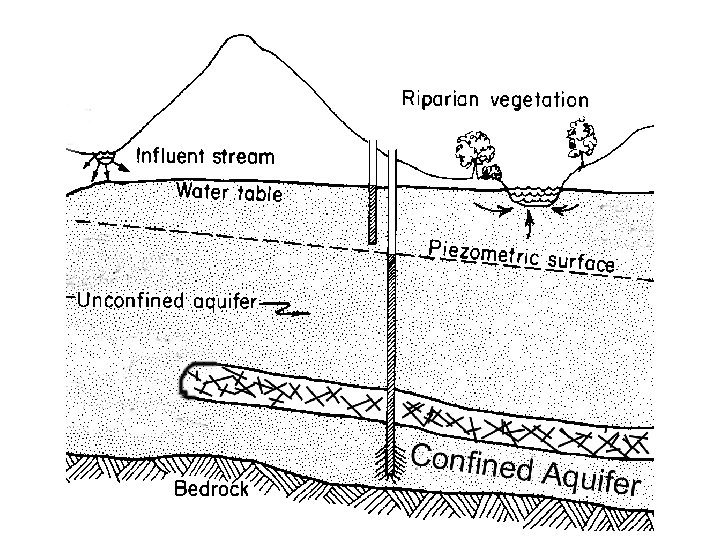
Confinement
Transmissivity • How much water can be moved horizontally – Function of thickness and Ksat – Good measure of well productivity – Floridan is the most transmissive aquifer in the world
Loss of Potential
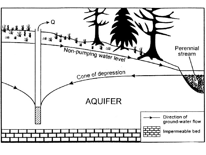
Potentiometric Surface • Elevation of “free water surface” • Where this surface and the ground intersect (and there’s no confinement) water seeps
Relevant Questions • Where is the water going? – Potentiometric (piezometric) surface • How much water is moving? How quickly? – Potentiometric surface and Darcys Law • What level of natural assimilation is occuring? – Water quality modeling
Gainesville’s Well Field Geology Land use Conservation Easement Also Lake City Jasper
Murphree Wellfield Cone of Depression 1988 (Observed) 2010 (Predicted)
How to make a sinkhole Pray for lots of Rain Suck a lot of water
Drilling and pumping Developed into a hole 300 ft deep and 300 ft wide Hundreds of sinkholes developed over a period of 6 hours.
Freeze Protection • To protect strawberry yield during a January freeze in 2010, ~ 2 billion gallons per day of water pumped over a 5 day period. Voila.
Groundwater and Wetlands
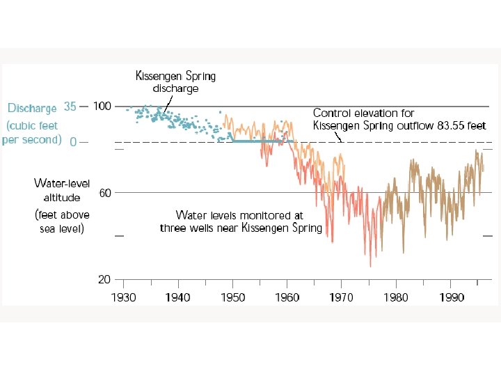
Subsidence Invasion Fire Degraded wildlife habitat
Artesian Springs • Where a confining layer exists, there may be a pressure potential in the aquifer HIGHER than the gravity potential of the surface. • When tapped, water flows upwards
P=Q+ET+G+ΔS Soil water movement across a watershed boundary. Q groundwater = K A ΔH/L Darcy’s Law Q is water crossing the defined area of the boundary in m 3/day Darcy’s law can calculate vertical leakage through a clay layer AND lateral flow through a seepage face.
Q= K A ΔH/L K is hydraulic conductivity, or the capacity of the media to transmit water Most meaningful as saturated hydraulic conductivity Ksat (m/day). Why?
Measuring Ksat • Constant Head Method – Constant depth of water (~50 mm) on top of a saturated soil column with known dimensions (diameter, length) – Outflow volume collected over a period of time (e. g. , 5 hrs) – Darcy’s Law to solve for Ksat
Measuring Ksat • Hvorslev Method – Field measurement in screened wells Log scale H/Ho K only determined casing 1. 8. 7. 6. 5 r H/Ho=. 37 . 4. 3 Le/R must be >8 . 2 Le t 37. 1 2 4 Gravel pack 6 minutes Linear scale 8 Screen 10 R high K material
Approximate Ksat and Uses Ksat (cm/h) Comments 36 Beach sand/Golf Course Greens 18 Very sandy soils, cannot filter pollutants 1. 8 Suitable for most agricultural, recreational, and urban uses 0. 18 <3. 6 x 10 -5 Clayey, Too slow for most uses Extremely slow; good if compacted material is needed
ΔH is the difference in H between two points Water flows from high ψtotal to low ψtotal (could be “up”) Point ψG ψP H A B C H = Ψgravity + Ψpressure H = level of water in an open well above some datum HA = ? HB = ? ΔH = ? Flow Direction? !?
H @ D? H@F? ΔH? 10 9 8 7 6 5 4 3 2 1 0 Direction?
ΔH AD? Dir? ΔH BF? Dir? ΔH AF? Dir? ΔH/L BF?
Vertical leakage problem Watershed=100 ha 6 5 4 3 Ksat=0. 001 m/d 2 1 0 Datum K? A? ΔH? L? Q=K A ΔH/L
Q = K * A * ΔH/L K = 0. 001 m/d A = 100 ha = 1, 000 m 2 ΔH = 5 -3 = 2 m L = 2 m Q = 0. 001 m/d x 1, 000 m 2 x 2 m / 2 m Q = 1, 000 m 3/day or 365, 000 m 3/year Q surface depth = 365, 000 m 3 / 1, 000 m 2= 0. 365 m
Lateral leakage problem Q=K A ΔH/L K=0. 1 m/d A=100 m x 50 m =5, 000 m 2 ΔH=108 m-105 m =3 m L=1, 000 m Qm 3/d= 0. 1 m/d * 5, 000 m 2 *0. 003 = 1. 5 m 3/d
Groundwater Flowpaths at Streams
Groundwater Discharges
Groundwater Flowpaths
Next Time… • Soil Water Storage