GPS radio occultation lecture 2 Extended applications Sean
 NWP SAF")


/b departure statistics from ECMWF operations for Aug. 20 to Sept.")
/b departure statistics from ECMWF operations for Aug. 20 to Sept.")
")

, 131, pp 3323 -3343 •")
 • Impact on bias correction.")

 Twelve month running average of tropical-mean temperature")
 Twelve month running average of tropical-mean temperature")
 GPS-RO has become a key observation type")


 RO mean tropospheric temperatures –– Measured (retrieved!!) geopotential")

 and MSU/AMSU (TLT) – bulk tropospheric temperatures –")

. Main")


/σ_o")


 applications: PBL height estimates, surface pressure information")

 It is a very interesting idea, which still needs to")


 ne(r) = TEC/√(2πe. H 2)")


- Slides: 57
GPS radio occultation lecture 2 Extended applications Sean Healy (sean. healy@ecmwf. int) NWP SAF lecture 2, April 5, 2017 http: //www. romsaf. org/
Contributions from • • • Chris Burrows Ian Culverwell Stig Syndergaard Hans Gleisner Torsten Schmidt Paul Poli Adrian Simmons Uli Foelsche Mark Ringer Mohamed Dahoui
Some useful presentations on GPS-RO applications • See presentations at: – http: //www. ecmwf. int/en/learning/workshops-and-seminars/past-workshops/fifth-eumetsat-rom-saf-userworkshop-applications-gps-radio-occultation-measurements EG, Atmospheric Studies with GPS-RO • Bill Randel (NCAR) – Tropopause studies with GPS-RO • Torsten Schmidt (Helmholtz Centre Potsdam) – Gravity wave studies using GPS-RO • Feiqin Xie (Texas A&M University-Corpus Christi) – Planetary boundary layer studies with GPS-RO
Outline Aim: provide an overview of GPS-RO applications Recap from lecture 1 – GPS-RO information content, key characteristics core region, etc. As you might expect, many applications are related to the GPS-RO measurement characteristics in the core region. • Key observation climate reanalyses (e. g. , ERA-Interim)/climate monitoring. • Forecast verification with GPS-RO, testing NWP/climate models. Outside the core region • Planetary boundary layer height estimates from GPS-RO. • Surface pressure information from GPS-RO. • Briefly Space weather/ionospheric applications. • Summary
Recap • GPS-RO measurements are useful because they complement satellite radiances. – Assimilation without bias correction – Good vertical resolution.
GPS-RO and IASI: 1 DVAR simulations Healy and Collard 2003, QJRMS: Power to resolve a peak-shaped error in background: Averaging Kernel. IASI Expected retrieval error: RO+IASI RO RO Background IASI
Recap • GPS-RO measurements are useful because they complement satellite radiances. – Assimilation without bias correction – Good vertical resolution • The information content is largest in the “core region”, between 7 -35 km, and we see a large NWP impact on upper-tropospheric and lower/middle stratospheric temperatures.
Climate reanalysis applications
Climate reanalysis applications • We have only had large quantities of RO since 2006. It is likely to become more useful for climate monitoring as the timeseries lengthens. • Claim: GPS-RO measurements should not be biased. – It should be possible to introduce data from new instruments without overlap periods for calibration. – No discontinuities in time-series as a result of interchange of GPS-RO instruments. • Bending angle time series derived from the ERA-Interim reanalysis can be used to investigate this claim.
Global bending angle (o-b)/b departure statistics from ECMWF operations for Aug. 20 to Sept. 20, 2009 GRAS COSMIC-6 COSMIC-4
Global bending angle (o-b)/b departure statistics from ECMWF operations for Aug. 20 to Sept. 20, 2009 I am always. GRAS a bit uneasy about saying GPS-RO are bias free. COSMIC-6 This difference in (o-b) statistics was traced to a COSMIC-4 smoothing of the COSMIC phase delays. Corrected in 2009.
Consistency of GPS-RO bending angles (ERA-Interim Reanalysis, Paul Poli)
GPS-RO and the bias correction of radiances • “Bias correction schemes for satellite radiances need to be grounded by a reference. ” The reference measurements are often called “anchor” measurements. • “Recommendation to NWP Centres to identify part of global observing system (e. g. high quality Radio-sondes, GPS Radio Occultation) as reference network which is actively assimilated but NOT bias corrected against an NWP system. ”
Var. BC is used at ECMWF Dee, QJRMS (2007), 131, pp 3323 -3343 • Bias corrected radiances are assimilated. In the 4 D-Var, we minimize an augmented cost function, where the bias coefficients are estimated. • Var. BC assumes an unbiased model.
Experiment removing GPS-RO from ERA-Interim (Dec. 08, Jan-Feb 09) • Impact on bias correction. E. g. , globally averaged Met. OP-A, AMSU-A channel 9 bias correction. GPS-RO assimilated No GPS-RO Bias correction applied to radiance
GPS-RO have improved the consistency between climate reanalyses in the uppertroposphere and lower/middle stratosphere Compare ERA-Interim, JRA-55, MERRA 2, reanalysis
Recent time-series computed by Craig Long (NOAA) Twelve month running average of tropical-mean temperature (K) at 100 h. Pa
Recent time-series computed by Craig Long (NOAA) Twelve month running average of tropical-mean temperature (K) at 100 h. Pa
Recent time-series computed by Craig Long (NOAA) GPS-RO has become a key observation type for climate reanalyses in the stratosphere in recent years. Twelve month running average of tropical-mean temperature (K) at 100 h. Pa
Climate monitoring applications GPS-RO likely to become more important for climate monitoring But which variables should we monitor? Bending angles or more geophysical quantities?
Recall basic GPS-RO processing chain: • Excess phase delays. • Doppler shift. • Bending angle. • Refractivity. • Pressure/Temp. Geopotential height.
Bending angle for climate monitoring Simulation study using the Hadley Centre climate model Simulation studies to assess: • potential of GPS-RO for detecting climate trends • what variable should we monitor • information content of GPS-RO in relation to other sensors Simulations use: • Met Office Hadley Centre coupled climate model (Had. GEM 1) • Climate change scenario (A 1 B) for 2000 – 2100 • Forward modelling of the GPS-RO bending angles Provided by Mark Ringer (Hadley Centre)
Initial comparison with observations Bending angle trends 2001 – 2011. Courtesy of Torsten Schmidt, GFZ, Potsdam, Germany.
Trends in the tropics may be detectable in about ~15 years Detection times (95% confidence intervals) 26 km: 9. 4 – 11. 7 years 20 km: 13. 6 – 18. 7 years 12 km: 14. 6 – 18. 2 years
Problem with monitoring bending angles • More difficult to interpret that geophysical quantities. • Most climate related work looks at temperature/geopotential heights.
ROM SAF work (Gleisner et al) RO mean tropospheric temperatures –– Measured (retrieved!!) geopotential height z(p) and mean virtual temperature: where For standard values of the constants, and at standard surface pressure (p. S), a 1 degree mean temperature increase of the atmospheric column raises the 100, 200, and 300 h. Pa pressure surfaces by 68, 47, and 36 meters, respectively. Issues to consider: is the atmosphere “dry” down to the selected isobar: difference between p and pdry surface pressure variability (1 h. Pa in surf. Pressure => 7 meter in geopot height) use of virtual temperature instead of physical temperature
Geopotential height at 300 h. Pa – CHAMP & COSMIC, global –
RO (gph at 300 h. Pa) and MSU/AMSU (TLT) – bulk tropospheric temperatures –
The Ro. Trends Project
ROtrends collaboration RO community started comparison of different processing centres in 2007 (ROtrends). Main aim is to validate RO as a climate benchmark, identifying the impact of processing assumptions (structural uncertainty). • • • ROtrends partners: DMI, JPL, GFZ, UCAR, WEGC, and EUMETSAT Common focus on CHAMP data, Aug 2001 to Sep 2008 Aiming at improved understanding of structural uncertainty while still keeping the algorithm/software development independent 1 st Round: profile-to-profile comparison between processing centres main results described in Ho et al. [2012] • 2 nd Round: comparison of monthly mean climatologies main results described in Steiner et al. [2013]
Initial RO-CLIM data set • • • CHAMP zonal monthly mean data: 5 deg x 200 m, 8 -30 km, global coverage To be provided with error characteristics and sampling-error corrected means To be provided as an ensemble of 5 or 6 data sets Currently no single community RO data set – discussions ongoing Planned to be released during 2015 (following re-formatting, documentation, etc) Current focus: a) multi-mission inter-comparisons, b) high-altitude initialization
Structural uncertainty: upper-level initialization Good agreement between ROM SAF and UCAR raw bending angles. Upper level bias between optimized and raw bending angles, leading to biases in refractivity and dry temperature. Blue lines: mean, st. dev. Red lines: median, MAD
Structural uncertainty: upper-level initialization Same as previous slide, but only including high-latitude data. Blue lines: mean, st. dev. Red lines: median, MAD
Structural uncertainty: upper-level initialization Same as previous slide, but only including high-latitude data. Blue lines: mean, st. dev. Red lines: median, MAD
Aim: Produce GPS-RO datasets and software for testing climate models • CFMIP Observation Simulator Package (COSP) (see A. Bodas. Salcedo et al, 2011: COSP: Satellite simulation software for model assessment. Bull. Amer. Meteor. Soc. , 92, 1023– 1043. • doi: http: //dx. doi. org/10. 1175/2011 BAMS 2856). • Satellite simulator package that enables testing climate models in measurement space using forward models. • We have recently introduced the 1 D bending angle operator into this package. • Work in progress, but the aim is to enable GCM developers to test their changes against robust GPS-RO climatologies.
One month of comparisons against COSMIC measurements. Provided by Alejandro Bodas-Salcedo.
NWP forecast verification in the stratosphere
Verification with GPS-RO in the stratosphere • Stratospheric forecasts are usually verified against analyses or radiosondes. • Some model changes can lead to big analysis differences, so having the option of verifying against obs. is important. • BUT, in the southern hemisphere, ECMWF only verifies against ~40 radiosonde sites, over land. • GPS-RO data are globally distributed, and reasonably good quality. • We can now verify a “day-n” forecast against GPS-RO bending angle profiles or the corresponding “classical” retrievals, assuming it is valid below ~5 h. Pa.
An example A recent operational upgrade improved the stratospheric forecasts, with BIG improvements for sudden stratospheric warming events. North pole day-6 forecast departures statistics for all GPS-RO data. Statistics for period Dec 20 -30, 2014. (ie first forecast valid Dec 26)
Forecast step, day-5 (O-F)/σ_o
GPS-RO retrieval with a-priori coming from a 6 hr forecast The agreement between GPS-RO and 6 hr forecast in the upper stratosphere / stratopause region is because the 6 hr fc is used in the GPS-RO retrieval
GPS-RO retrieval with a-priori coming from a 6 hr forecast The agreement between GPS-RO and 6 hr forecast in the upper stratosphere / stratopause region is because the 6 hr fc is used in the GPS-RO retrieval
EXAMPLE 2. 5 months of statistics Mapping the bending angle information to temperature space. We’ve integrated the temperature retrieval into the statistics package. • See both the bending angle and temp. statistics Confident in the quality of the temp. retrievals from the tropopause up to ~10 h. Pa.
Novel (surprising) applications: PBL height estimates, surface pressure information
Novel applications: Deriving planetary boundary layer information from GPSRO measurement • Some papers have suggested that we should be able to derive information on the height of the planetary boundary layer from the GPSRO bending angle and refractivity profiles. – Sokolovskiy et al, 2007, GRL, 34, L 18802, doi 10. 1029/2007 GL 030458 – Von. Engeln et al, 2005, GRL, 32, L 06815, doi 10. 1029/2004 GL 022168 • The central idea is that you see big changes in the bending angle and refractivity profile gradient across the top of the PBL.
Sokolovskiy et al, (2007) It is a very interesting idea, which still needs to be investigated further. Horizontal gradient errors. Meaning of PBL height averaged over 300 -400 km?
Horizontal gradient error simulations Gradients in the ionosphere! Red=L 1 Green=L 2 Blue=corrected Black no-iono simulation From Zeng et al, Atmos. Meas. Tech. , 9, 335 -346, 2016. Recall: Ionospheric gradients causing a PBL height error!
Surface pressure information from GPS-RO • Measuring or retrieving surface pressure information from satellite radiances has been discussed for many years (Smith et al, 1972). • The GPS-RO measurements have a sensitivity to surface pressure because they are given as a function of height. • Hydrostatic integration is part of the GPS-RO forward model. If we increase the surface pressure the bending angle values increase. • Can GPS-RO constrain the surface pressure analysis when all conventional surface pressure measurements are removed?
NH 12 hour PMSL forecast scores Mean Standard deviation GPS-RO included. The GPS-RO measurements manage to stabilise the bias.
Space weather/ionospheric applications
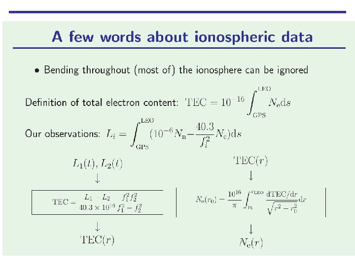
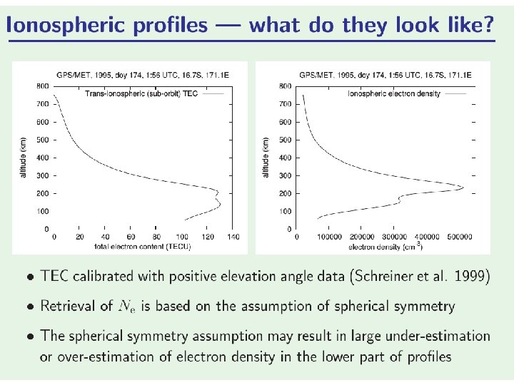
Retrieval methods are similar to the classical retrieval Bending is small and is usually neglected The excess phase delay: These can be directly assimilated into ionospheric data assimilation systems neutral electron density
Why is the ionospheric work of interest to us? If we want to improve upon the standard ionospheric correction for neutral applications: we need to include some a-priori information about the ionospheric state. One idea is the direct assimilation of L 1, L 2 bending angles by estimating the ionospheric model parameters as part of the 1 D-Var retrieval.
Model ionosphere: electron density Single Chapman Layer (Chapman 1931) ne(r) = TEC/√(2πe. H 2) · exp(½(1 – u – e-u)), where u = (r – r 0) / H. 3 parameters: TEC = ∫ ne dr r 0 = peak height H = ionospheric scale height
First application The ionospheric correction becomes part of the forward modelling. The retrieved ionospheric parameters can be discarded. L 1, L 2 bending angles look reasonable but more work required here.
Summary • A comprehensive set of talks on the applications of GPS-RO data can be found at: – http: //www. ecmwf. int/en/learning/workshops-and-seminars/past-workshops/fifth-eumetsat-rom-saf-userworkshop-applications-gps-radio-occultation-measurements • Many current applications are related to the GPS-RO measurement characteristics in the core-region. Impact in reanalysis established. • We expect the GPS-RO climate applications to increase as timeseries lengthens. • Novel applications PBL heights, surface pressure. • Use of GPS-RO for ionospheric applications, and we are expecting increased collaboration between the ionospheric and neutral at. Communities.