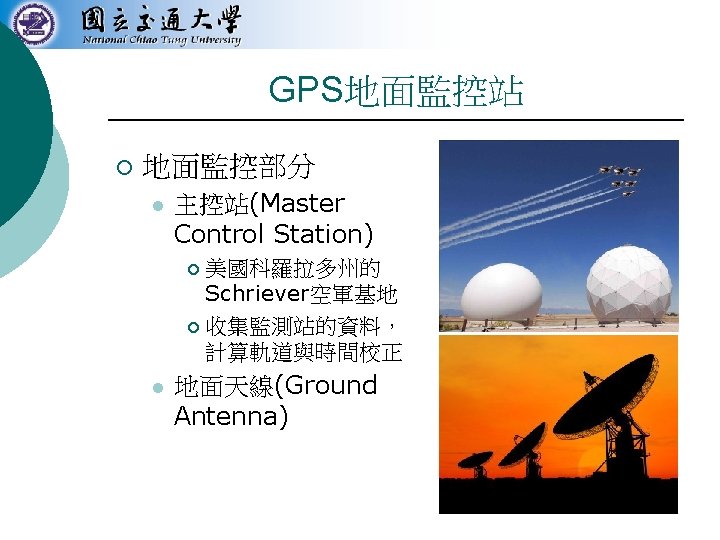
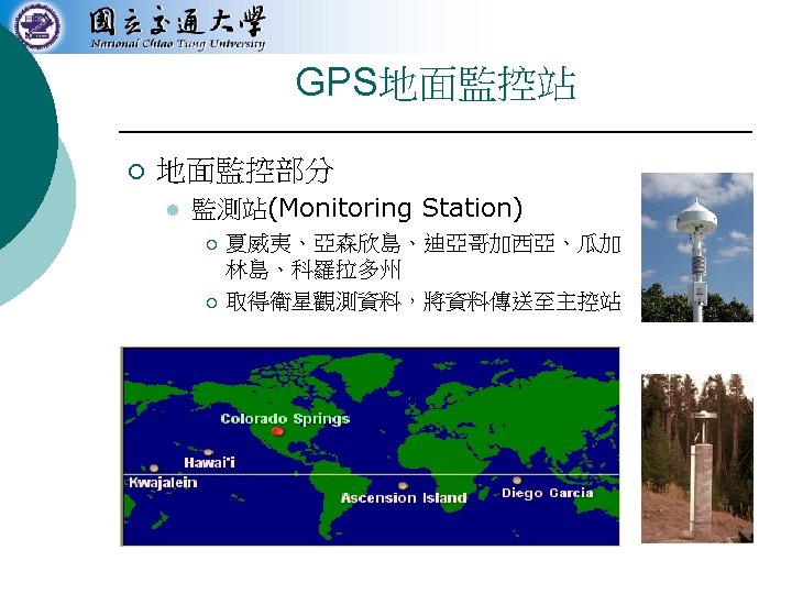
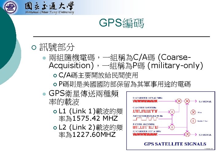
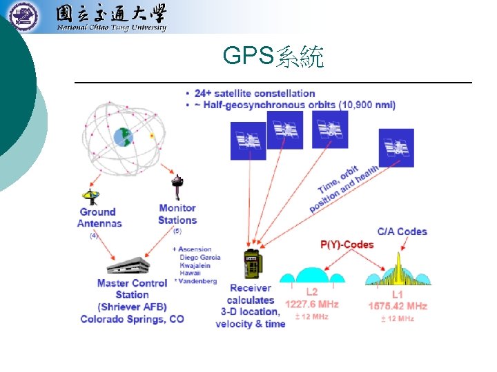
Wireless Network Chapter 18 GPS GPS Block III

無線網路 Wireless Network Chapter 18 GPS定位技術

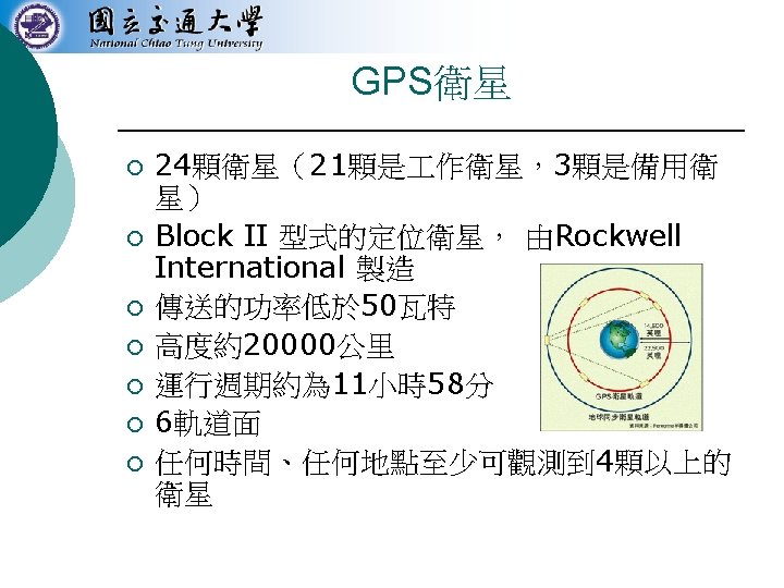

GPS衛星 Block III


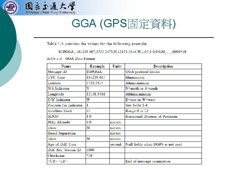
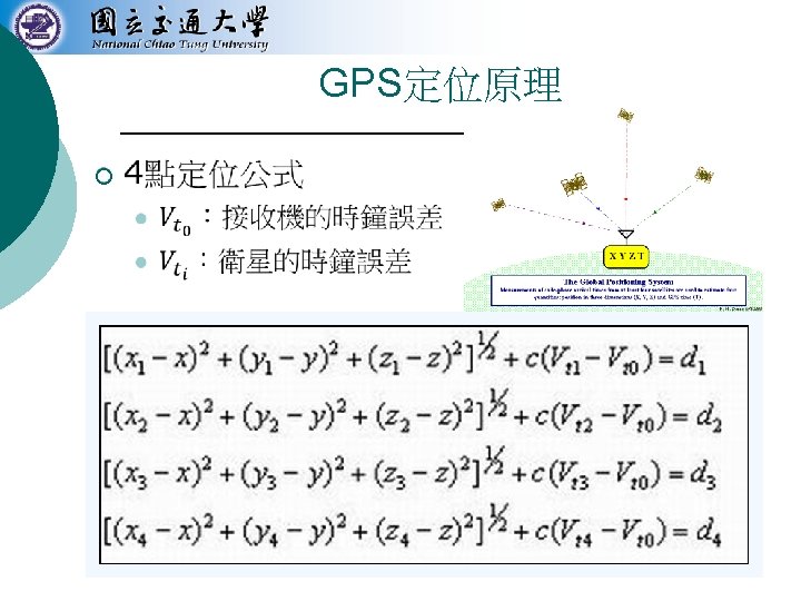
GPS訊號格式 ¡ NMEA 0183 l l ¡ 格式 l l l ¡ 美國國家海洋電子學會 大部份的GPS receiver都具有此標準規格 ASCII Sentence $. . <CR><LF> 常用 l l l GGA: Global Positioning System Fixed Data RMC: Recommended Minimum Specific GNSS Data GSA: GNSS DOP and Active Satellites GSV: GNSS Satellites in View GLL: Geographic Position - Latitude/Longitude VTG: Course Over Ground and Ground Speed
 l l l ¡ 水平精度 17. 8 m")
精確度 ¡ 精確定位系統(Precise Positioning System, PPS) l l l ¡ 水平精度 17. 8 m 垂直精度 27. 7 m 時間精度 100 ns 標準定位系統(Standard Positioning System, SPS) l l l 水平精度 100 m 垂直精度 156 m 時間精度 167 ns

SA的影響 On May 2, 2000, SA was disabled by then President of the United States Bill Clinton, and in late 2001, the entity managing the GPS confirmed that they never intend to enable selective availability again. Though Selective Availability still exists, on 19 September 2007, the US Department of Defense announced that the new GPS satellites will not be capable of implementing Selective Availability. Block IIF satellites launched in 2009 (and all subsequent GPS satellites) do not support SA.
 ¡ DGPS (Differential GPS) ¡ l l")
改善GPS AGPS (Aiding GPS or Assisted GPS) ¡ DGPS (Differential GPS) ¡ l l ¡ WAAS (Wide Area Augmentation System) LAAS (Local Area Augmentation System) RTK (Real Time Kinematic)
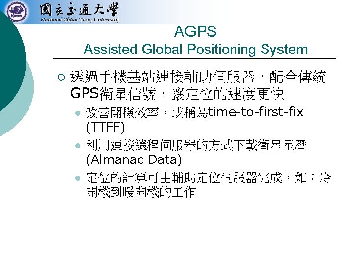

AGPS Architecture
 to about 10")
Differential GPS ¡ Improve positioning accuracy from 15 m (nominal GPS) to about 10 cm. l Fixed ground-based reference stations ¡ ¡ l ¡ Measure the difference between the measured satellite pseudoranges and actual (internally computed) pseudoranges. Broadcast the difference and the known position GPS receivers may correct their pseudoranges by the same amount. E. g. , USCG and CCG have such a system on the longwave radio frequencies between 285 k. Hz and 325 k. Hz near major waterways and harbors.

Wide Area Augmentation System ¡ ¡ ¡ “Essentially, WAAS is intended to enable aircraft to rely on GPS for all phases of flight, including precision approaches to any airport within its coverage area. ” It is a satellite-based augmentation system (SBAS) developed by the Federal Aviation Administration. System architecture l A network of ground-based reference stations ¡ ¡ l Measure the GPS satellites' signals Send correction messages to WAAS satellites Geostationary WAAS satellites ¡ ¡ Receive the correction messages Broadcast the correction messages back to Earth

WAAS Architecture
 ¡ ¡ ¡ Ground Based Augmentation System (GBAS) An")
Local Area Augmentation System (LAAS) ¡ ¡ ¡ Ground Based Augmentation System (GBAS) An all-weather aircraft landing system based on real-time differential correction of the GPS signal System architecture l l ¡ Local reference receivers located around the airport send data to a central location at the airport. This data is used to formulate a correction message, which is then transmitted to users via a VHF Data Link. Accuracy l l Currently, Category I ILS accuracy of 16 m laterally and 4 m vertically Future, Category III ILS capability that will allow aircraft to land with zero visibility utilizing 'autoland' systems
 ¡ ¡ ¡ Real Time Kinematic (RTK) satellite navigation based")
Real Time Kinematic (RTK) ¡ ¡ ¡ Real Time Kinematic (RTK) satellite navigation based on the use of carrier phase measurements provides realtime corrections up to centimeterelevel accuracy. Referred to as Carrier-Phase Enhancement for GPS (CPGPS) in particular The difficulty in making an RTK system is properly aligning the signals.

Concepts of RTK ¡ In general receivers are able to align the signals to about 1% of one bit-width l l ¡ The coarse-acquisition (C/A) code sent on the GPS system sends a a bit every 0. 98 microsecond, so a receiver is accurate to 0. 01 microsecond, or about 3 meters in terms of distance The military-only P(Y) signal sent by the same satellites is clocked ten times as fast, so with similar techniques the receiver will be accurate to about 30 cm. RTK follows the same general concept, but uses the satellite's carrier as its signal, not the messages contained within. l l The GPS C/A code broadcast in the L 1 signal changes phase at 1. 023 MHz, but the L 1 carrier itself is 1575. 42 MHz, over a thousand times as fast. This frequency corresponds to a wavelength of 19 cm for the L 1 signal. Thus a ± 1% error in L 1 carrier phase measurement corresponds to a ± 1. 9 mm error in baseline estimation.

GLONASS ¡ Global Navigation Satellite System l ¡ Operated for the Russian government by the Russian Aerospace Defence Forces l l l ¡ ¡ Globalnaya navigatsionnaya sputnikovaya sistema Development began in 1976 Beginning on 12 October 1982 Completed in 1995 Achieved 100% coverage of Russia's territory (2010) and full global coverage (Oct. 2011) after the full orbital constellation of 24 satellites was restored. GLONASS is currently the most expensive program of the Russian Federal Space Agency, consuming a third of its budget in 2010.

GLONASS Facts ¡ Satellite orbit l l l ¡ Constellation l l ¡ Altitude: 19, 100 km (middle circular orbit ) Inclination: 64. 8 degree Period: 11 hours and 15 minutes 3 orbital planes with 8 evenly spaced satellites on each 24 satellites for fully global coverage, and 18 satellites for covering the territory of Russia Accuracy (as of 2010) l l Precisions of GLONASS navigation definitions (for p=0. 95) for latitude and longitude were 4. 46 -7. 38 m with mean number of NSV equals 7 -8 Precisions of GPS navigation definitions were 2. 008. 76 m with mean number of NSV equals 6 -11
, developed by China l")
Compass Navigation System ¡ Also known as Beidou-2 (BD 2), developed by China l l l ¡ Constellation l ¡ ¡ With coverage of China and surrounding areas (Dec. 2011) Asia-Pacific region by 2012 Global coverage by 2020 35 satellites including 5 geostationary orbit (GEO) satellites and 30 medium Earth orbit (MEO) satellites Two levels of positioning service: open and restricted (military) Accuracy l Trial run (December 201) ¡ l Positioning: 25 meters Officially launched next year ¡ ¡ ¡ Positioning: 10 m Speed: 0. 2 m/s Clock synchronization: 0. 02 microseconds
 and European Space")
Galileo Positioning System ¡ Being built by the European Union (EU) and European Space Agency (ESA) l l ¡ Blueprint l l ¡ To provide a high-precision positioning system Provide a global Search and Rescue (SAR) function Two ground operations centres, near Munich, Germany and in Fucino, Italy. As of 2011, initial service is expected around 2014 and completion by 2019. Galileo satellites l l l 30 in-orbit spacecraft (including 3 spares) Altitude: 23, 222 km (MEO) 3 orbital planes ¡ ¡ 56° inclination, ascending nodes separated by 120° longitude 9 operational satellites and one active spare per orbital plane
")
Global Navigation Satellite System (GNSS)
- Slides: 41