GOVERNMENT COLLEGE FOR WOMEN AUTONOMOUS KUMBAKONAM DEPARTMENT OF
 KUMBAKONAM DEPARTMENT OF GEOGRAPHY I – M. Sc -")
GOVERNMENT COLLEGE FOR WOMEN (AUTONOMOUS) KUMBAKONAM DEPARTMENT OF GEOGRAPHY I – M. Sc - GEOGRAPHY APPLIED GEOMORPHOLOGY - UNIT: II GLACIAL LANDFORMS Dr. B. ANUSUYA, Assistant Professor & Head, Department of Geography, Government College for Women (A), Kumbakonam.

UNIT: II APPLIED GEOMORPHOLOGY - P 18 GC 101 GLACIAL LANDFORMS Definition of Glaciar Landforms : What is a Glacier? Glaciers are a mass of ice moving under its own weight. They are commonly found in the snow-fields. We know that the landmass on the earth is not entirely the same as we see around. Some areas are covered by thick green forests, some with dry hot deserts, some with permanent ice covers etc. Among these varied landmasses, the permanently ice-covered regions on the earth surface are called as snow-fields. The lowest limit of permanent snow or snow-field is called as the snowline.

• A Glacier forms in areas where the accumulation of snow exceeds its ablation (melting and sublimation) over many years, often centuries. • They form features like crevasses, seracs etc. A crevasse is a deep crack, or fracture, found in an ice sheet or glacier, as opposed to a crevice that forms in rock. A serac is a block or column of glacial ice, often formed by intersecting crevasses on a glacier. • Ogives are alternating wave crests and valleys (troughs) that appear as dark and light bands of ice on glacier surfaces. They are linked to seasonal motion of glaciers; the width of one dark and one light band generally equals the annual movement of the glacier.

• On the basis of the location of the glacier, they can be classified as: • Continental Glacier/Piedmont Glacier: they move outward in all directions • Valley/Mountain Glaciers: Move from higher elevation to What types of glaciers are there? Mountain glaciers. Variegated Glacier is a valley glacier that winds through the Saint Elias Mountains in Alaska, terminating near Yakutat Bay. Valley glaciers. Tidewater glaciers. Piedmont glaciers. Hanging glaciers. Cirque glaciers. Ice Aprons. Rock Glaciers. Ice shelves. Icefields.

• What types of glaciers are there? • Mountain glaciers • These glaciers develop in high mountainous regions, often flowing out of icefields that span several peaks or even a mountain range. The largest mountain glaciers are found in Arctic Canada, Alaska, the Andes in South America, and the Himalaya in Asia. • Valley glaciers • Commonly originating from mountain glaciers or icefields, these glaciers spill down valleys, looking much like giant tongues. Valley glaciers may be very long, often flowing down beyond the snow line, sometimes reaching sea level.

• Tidewater glaciers As the name implies, these are valley glaciers that flow far enough to reach out into the sea. In some locations, tidewater glaciers provide breeding habitats for seals. Tidewater glaciers are responsible for calving numerous small icebergs, which although not as imposing as Antarctic icebergs, can still pose problems for shipping lanes. • Piedmont glaciers occur when steep valley glaciers spill into relatively flat plains, where they spread out into bulb-like lobes. Malaspina Glacier in Alaska is one of the most famous examples of this type of glacier, and is the largest piedmont glacier in the world. Spilling out of the Seward Icefield, Malaspina Glacier covers about 3, 900 square kilometers (1, 500 square miles) as it spreads across the coastal plain.

Tidewater Glacier

Hanging glaciers When a major valley glacier system retreats and thins, sometimes the tributary glaciers are left in smaller valleys high above the shrunken central glacier surface. These are called hanging glaciers. If the entire system has melted and disappeared, the empty high valleys are called hanging valleys. Cirque glaciers are named for the bowl-like hollows they occupy, which are called cirques. Typically, they are found high on mountainsides and tend to be wide rather than long. Ice aprons These small, steep glaciers cling to high mountainsides. Like cirque glaciers, they are often wider than they are long. Ice aprons are common in the Alps and in New Zealand, where they often cause avalanches due to the steep inclines they occupy.

Rock glaciers are combinations of ice and rock. Although these glaciers have similar shapes and movements as regular glaciers, their ice may be confined to the glacier core, or may simply fill spaces between rocks. Rock glaciers may form when frozen ground creeps downslope. They may also accumulate ice, snow, and rocks through avalanches or landslides.

• Ice Caps • Ice caps are miniature ice sheets, covering less than 50, 000 square • • kilometers (19, 305 square miles). They form primarily in polar and sub-polar regions and are smaller than continental-scale ice sheets. Ice Fields Icefields are similar to ice caps, except that their flow is influenced by the underlying topography, and they are typically smaller than ice caps. Ice Streams Ice streams are large ribbon-like glaciers set within an ice sheet, they are bordered by ice that is flowing more slowly, rather than by rock outcrop or mountain ranges. These huge masses of flowing ice are often very sensitive to changes such as the loss of ice shelves at their terminus or changing amounts of water flowing beneath them. The Antarctic ice sheet has many ice streams.

• Ice Sheets Found now only in Antarctica and Greenland, ice sheets are enormous continental masses of glacial ice and snow expanding over 50, 000 square kilometers (19, 305 square miles). The ice sheet on Antarctica is over 4. 7 kilometers (3 miles) thick in some areas, covering nearly all of the land features except the Transantarctic Mountains, which protrude above the ice. Another example is the Greenland Ice Sheet. In the past ice ages, huge ice sheets also covered most of Canada (the Laurentide Ice Sheet) and Scandinavia (the Scandinavian Ice Sheet), but these have now disappeared, leaving only a few ice caps and mountain glaciers behind.

• Ice Shelves • Ice shelves occur when ice sheets extend over the sea and float on the water. They range from a few hundred meters to over 1 kilometer (0. 62 mile) in thickness. Ice shelves surround most of the Antarctic continent.

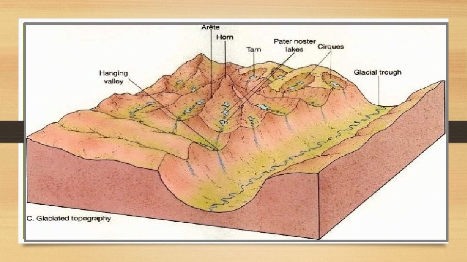
Glacial Cycle of Erosion • Youth • The stage is marked by the inward cutting activity of ice in a cirque. • Aretes and horns are emerging. The hanging valleys are not • • • prominent at this stage. Maturity Hanging valleys start emerging. The opposite cirques come closer and the glacial trough acquires a stepped profile which is regular and graded. Old Age Emergence of a ‘U’-shaped valley marks the beginning of old age. An outwash plain with features such as eskers, kame terraces, drumlins, kettle holes etc. is a prominent development.

Erosional landforms • As the glaciers expand, due to their accumulating weight of snow and ice they crush and abrade and scour surfaces such as rocks and bedrock. The resulting erosional landforms include striations, cirques, glacial horns, arêtes, trim lines, U-shaped valleys, roches moutonnées, overdeepenings and hanging valleys.

• Erosional landforms due to Glaciers • 1. Cirque or Corris • They are deep, long and wide troughs or basins with very steep concave to vertically dropping high walls at its head as well as sides. • They are simply a bowl-shaped depression formed due to the erosional activity of glaciers. • When these depressions are filled with water, they are called as Cirque lake or Corrie Lake or Tarn
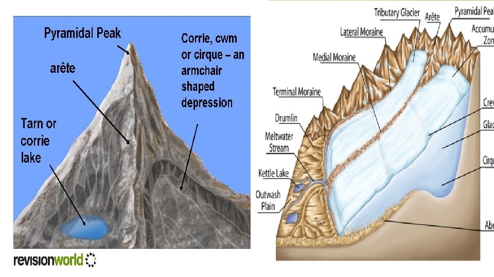

2. Hanging Valleys or U-shaped Valleys, Fjords/fiords • The Glacier doesn’t create a new valley like a river does but deepens and widens a preexisting valley by smoothening away the irregularities. • These valleys, which are formed by the glacial erosions assume the shape of letter ‘U’ and hence are called as U-shaped Valleys or Hanging Valleys. • A fjord is a very deep glacial trough filled with sea water and making up shorelines. • A fjord is formed when a glacier cuts a Ushaped valley by ice segregation and abrasion of the surrounding bedrock and this valley gradually gets filled with the seawater (formed in mountains nearby sea).

• Horns and Aretes • Horns are sharp pointed and steep-sided peaks. • They are formed by headward erosion of cirque wall. • When the divide between two cirque walls gets narrow because of progressive erosions, it results in the formation of a saw-toothed ridge called Arete.

• U-shaped valleys, trough valleys or glacial troughs, are formed by the process of glaciation. They are characteristic of mountain glaciation in particular. [1] They have a characteristic U shape, with steep, straight sides and a flat or rounded bottom (by contrast, valleys carved by rivers tend to be V-shaped in cross-section). Glaciated valleys are formed when a glacier travels across and down a slope, carving the valley by the action of scouring. [2] When the ice recedes or thaws, the valley remains, often littered with small boulders that were transported within the ice, called glacial till or glacial erratic. • Examples of U-valleys are found in mountainous regions like the Andes, Alps, Caucasus Mountains, Himalaya, Rocky Mountains, New Zealand the Scandinavian Mountains. They are found also in other major European mountains including the Carpathian Mountains, the Pyrenees, the Rila and Pirin mountains in Bulgaria, and the Scottish Highlands. A classic glacial trough is in Glacier National Park in Montana, USA in which the St. Mary River runs. Another famous Ushaped valley is the Nant Ffrancon Valley in Snowdonia, Wales.

When a U-shaped valley extends into saltwater, becoming an inlet of the sea, it is called a fjord, originally the Norwegian word for these formations that are common in Norway. Outside of Norway, a classic U-shaped valley that is also a fjord is the Western Brook Pond Fjord in Gros Morne National Park in Newfoundland, Canada. Typically, a valley formed by glaciers has a series of basins with intervening steps formed by the locally varying erosion depths of valley glaciers. After the ice melts, this initially becomes a sequence of lakes with intermediate rapids or waterfalls. The transportation of gravels, erosion and sedimentation processes in the streams lead to the formation of sequences of flat valley bottoms and gorges.

Such basin forms, with an abrupt beginning, often appear as marked steps, which may separate the flatter sections of the valley. Large steps were often formed where the erosion forces of the glacier that once filled the valley were suddenly increased, for instance, when large glaciers merged. They are then referred to as confluence steps. Similar steps are formed when moving sheets of ice merge into glacial streams, which can intensify surface scouring of the rocks (exaration). If these valley steps are close to the upper end of a valley, they are also referred to as a valley head or trough head; otherwise, they subdivide the course of the valley into often very distinct individual valley sections, with gentler and broader hollows alternating, chain-like, with and narrow intermediate valleys or gorges. In the interior of mountain ranges, these valleys dictate the structure of settlements, and may result in isolated

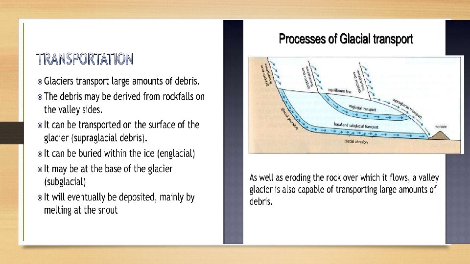
• Glacial Landforms and Cycle of Erosion • A glacier is a moving mass of ice at speeds averaging few meters a day. • Types of Glaciers: continental glaciers, ice caps, piedmont glaciers and valley • • glaciers. The continental glaciers are found in the Antarctica and in Greenland. The biggest continental ice sheet in Ice caps are the covers of snow and ice on mountains from which the valley or mountain glaciers originate. The piedmont glaciers form a continuous ice sheet at the base of mountains as in southern Alaska. The valley glaciers, also known as Alpine glaciers, are found in higher regions of the Himalayas in our country and all such high mountain ranges of the world. The largest of Indian glaciers occur in the Karakoram range, viz. Siachen (72 km), while Gangotri in Uttar Pradesh (Himalayas) is 25. 5 km long. A glacier is charged with rock debris which are used for erosional activity by moving ice. A glacier during its lifetime creates various landforms which may be classified into erosional and depositional landforms.

• Cirque/Corrie • Hollow basin cut into a mountain ridge. • It has steep sided slope on three sides, an open end on one side and a flat bottom. • When the ice melts, the cirque may develop into a tarn lake. • Glacial Trough • Original stream-cut valley, further modified by glacial action. • It is a ‘U’ Shaped Valley. It at mature stage of valley formation. • Since glacial mass is heavy and slow moving, erosional activity is uniform – horizontally as well as vertically. • A steep sided and flat bottomed valley results, which has a ‘U’ shaped profile.

• Hanging Valley • Formed when smaller tributaries are unable to cut as deeply as bigger ones and remain ‘hanging’ at higher levels than the main valley as discordant tributaries. • A valley carved out by a small tributary glacier that joins with a valley carved out by a much larger glacier. • Arete • Steep-sided, sharp-tipped summit with the glacial activity cutting into it from two • Horn • Ridge that acquires a ‘horn’ shape when the glacial activity cuts it from more than two sides. • D-Fjord • Steep-sided narrow entrance-like feature at the coast where the stream meets the coast. • Fjords are common in Norway, Greenland New Zealand.
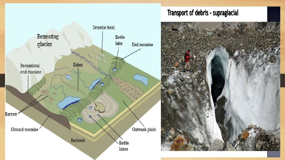

Glacial Depositional Landforms • Outwash Plain • When the glacier reaches its lowest point and melts, it leaves behind a stratified deposition material, consisting of rock debris, clay, sand, gravel etc. This layered surface is called till plain or an outwash plain. • Esker • Winding ridge of un-assorted depositions of rock, gravel, clay etc. running along a glacier in a till plain. • The eskers resemble the features of an embankment and are often used for making roads.

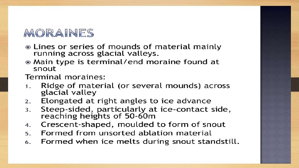
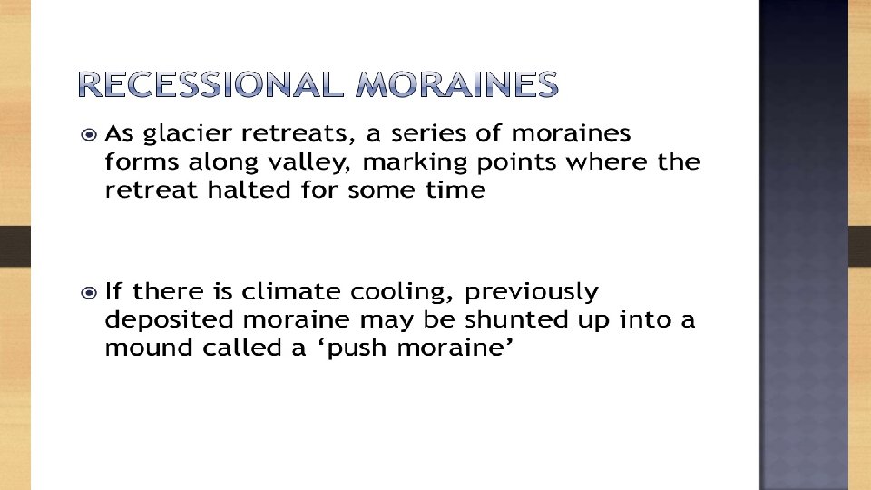
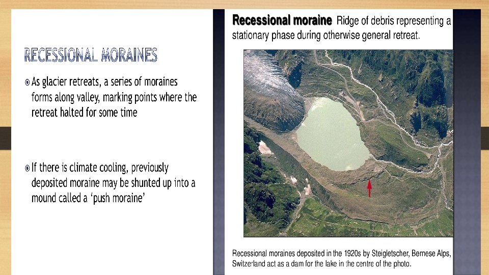
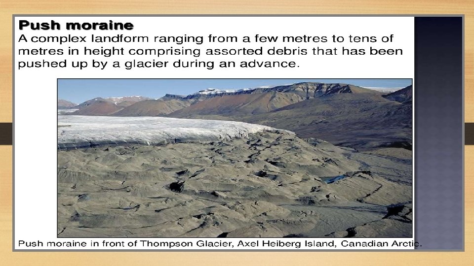
• Kame Terraces • Broken ridges or un-assorted depositions looking like • • hump in a till plain. Drumlin Inverted boat-shaped deposition in a till plain caused by deposition. Kettle Holes Formed when the deposited material in a till plain gets depressed locally and forms a basin. Moraine General term applied to rock fragments, gravel, sand, etc. carried by a glacier. Depending on its position, the moraine can be ground moraine and end moraine.

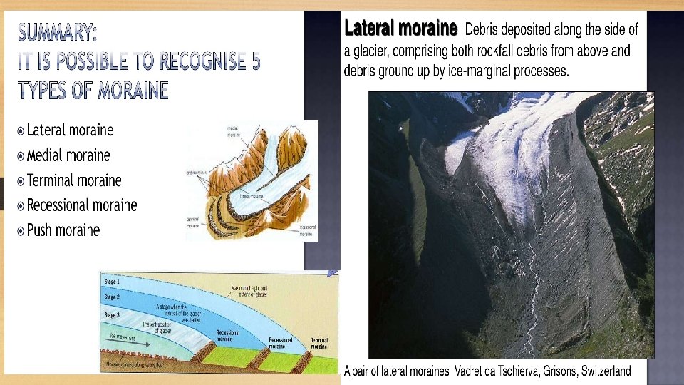
• Moraines are long ridges of deposits of glacial till. • When these deposits are at the end of a glacier, they are called as Terminal moraines and when they are deposited on both sides, they are called as Lateral moraines. • When lateral moraines of two glaciers join together, they form Medial moraines. • When the lateral moraines of both sides of a glacier join together, it forms a horse-shoe shape. • Ground moraines are deposits left behind in areas once covered by glaciers.

• Eskers • When glaciers melt in summer, the water which formed as a result of melting accumulates beneath the glacier and flows like streams in channels beneath that ice. • Very coarse material like boulders, blocks and some minor fractions of rock debris are carried away by these streams. • They later get deposited in the valleys itself and once the ice melts completely, they are visible to the surface as sinuous ridges. • These ridges are called as Eskers.

• Drumlins • They are smooth oval-shaped ridge-like structures composed mainly of glacial till. • It shapes like an inverted spoon with the highest part is called as Stoss End and the lowest narrow part is called as Tail End. • They are formed as a result of glacial movement over some minor obstruction like small surface rocks. • The glacial till gets deposited in those obstructions and the movement of glacier shapes these deposits like an inverted

Thank you
- Slides: 38