Glacial Erosion Ch 15 p 277 281 Glaciers


 Continental (ice sheets) �Mountainous areas �long, narrow-wedged")


. jpg")


 �TILL- unsorted; deposited by ice �STRATIFIED DRIFT- layered (sorted")
- Slides: 50
Glacial Erosion Ch 15: p 277 -281
Glaciers: ØEnormous masses of moving ice created by the accumulation and compaction of snow. ØPowerful agents of erosion ~ have carved some of the most spectacular features on Earth’s surface ØThe growth of a glacier depends on whether the snowfall from winter is greater than the snow melt in summer!
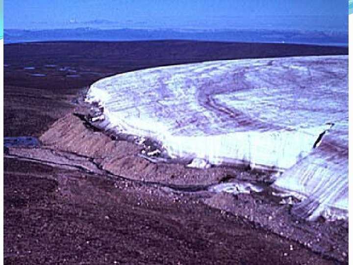
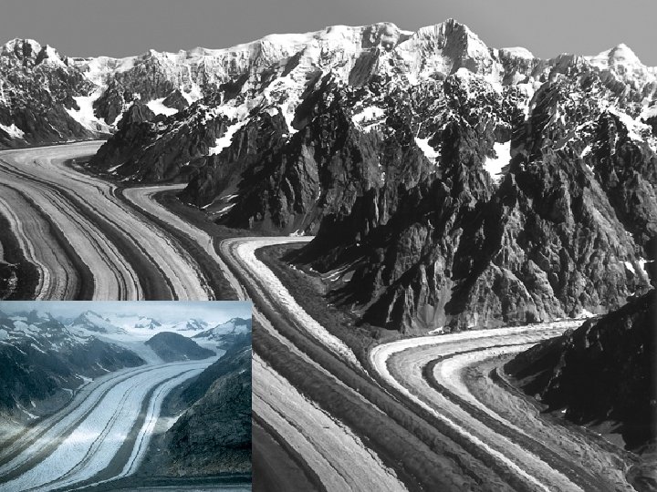
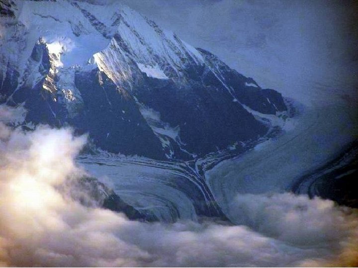
2 types of Glaciers: Alpine (aka Valley) Continental (ice sheets) �Mountainous areas �long, narrow-wedged mass of ice �Best developed valley glaciers found in Alaska, the Himalayas, the Alps… �Covers large land areas �Found only in Greenland Antarctica today
Valley Glacier
Continental ice sheet The Antarctic Ice Sheet is 1. 5 times the size of the US and in some places more than 4, 000 m thick
How Glaciers form:
Step 1: Snow accumulates. More snow falls during the winter than melts in the summer.
Trans-Labrador Highway http: //tlhwy. com/south/winter/index. html
Step 2: Snow changes to firn. As snow accumulates, its weight compresses the individual snowflakes to form firn.
Step 3: Firn is compressed to form solid glacial ice
Step 4: The ice begins to move. Continental Valley
Some Facts �Glaciers hold 75% of the Earth’s fresh water. � 10% of land is covered by them. �If they all melted the sea level would go up about 70 m �Artic ice is over 4, 200 m thick in some spots.
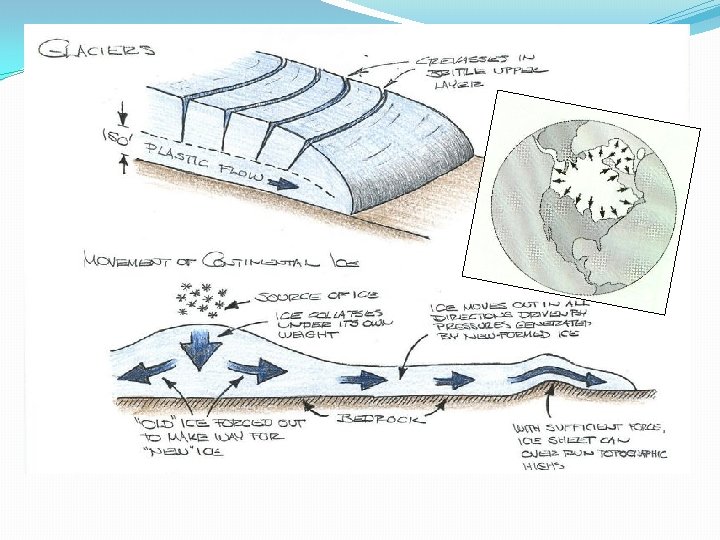
2 types glacial movement: Basal Slip Internal plastic flow �The weight of the ice exerts enough pressure to melt the ice where it contacts the ground �This melt water acts as a lubricant and allows the glacier to slip forward, including over small barriers �The weight of the ice and gravity causes the ice crystals to slip over each other �Speed of this flow is faster nearer the surface and at its center…why? . . . � friction!
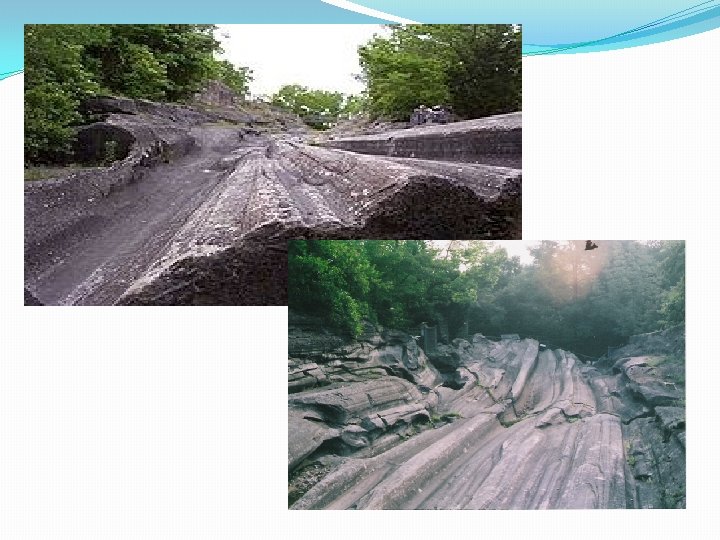
How do glaciers erode the surface? �Plucking – freeze/thaw process lifts particles into ice �Abrasion- like sandpaper-rocks caught up on the bottom scrape the ground under it, making striations
Glaciers pick up lots of sediment as they advance over the land. http: //www. geographyjim. org/Newzealandglacier. jpg
http: //daac. gsfc. nasa. gov/DAAC_DOCS/geomorphology/GE O_9/geo_images_9/Fig 9. 20. gif
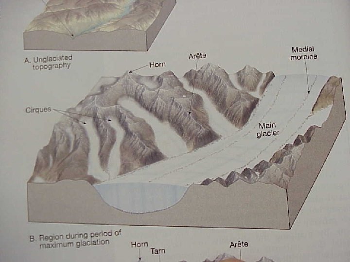
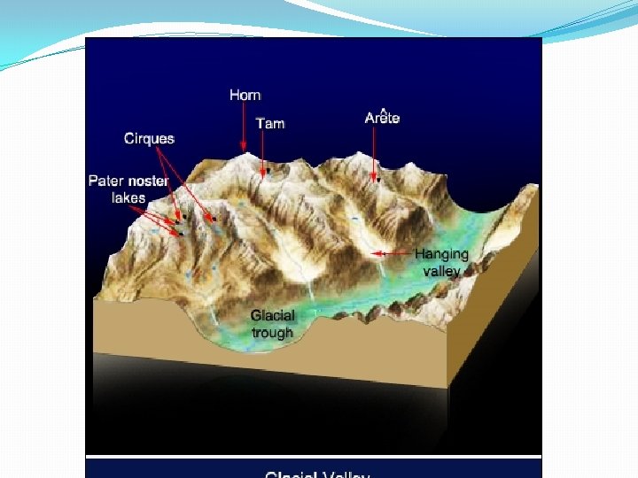
Cirque �A bowl-shaped depression located where a glacier begins to form
http: //crevassezone. org/Photos/Graphics/4163 L-(Cirque). jpg
Horn Kinnerly Peak - Glacier National Park �A tall, pointed rock peak left at the top of a mountain http: //www 2. nature. nps. gov/geology//parks/glac/car 0348. jpg
The most famous horn in the Alps… The Matterhorn �Located on the boundary between Switzerland Italy, the Matterhorn’s summit is 4478 m above sea level.
Arete – spines or ridges of rock that separate glacial valleys
U-shaped Valley - Yosemite National Park
V-shaped valleys become U-shaped valleys as glaciers move through them… Step 1 Step 3 A typical river valley Glacier fills valley, widening and straightening the channel Step 2 Step 4 Over time, running water cuts a deeper V -shape. Glaciers melt leaving a U-shaped valley
U-Shaped Valley Formation
Hanging Valley �a small valley that has not eroded as deep as the main valley that it is connected to �Waterfalls often form at hanging valleys.
Striations- parallel scratches made from rocks in ice scraping against bedrock
l Kett s e k e La A shallow body of water made from ice blocks
Glacial Deposition: �Drumlins--hills of sediment deposited by the glacier- till
Drumlin Formation
Glacial DEPOSITION �Eskers �Winding ridges of stratified drift �Deposited by meltwater streams �Mined for gravel (aggregate)
Esker Formation
Glacial DEPOSITION �Kames �Cone shaped stratified deposits �Deposited at end of meltwater streams
Kames
MORAINES moraine outwash http: //www. helsinki. fi/~jhyvonen/PB/M/Cerro%20 Tronador%20 moraine-pp. JPG �MADE OF TILL- unsorted sediment
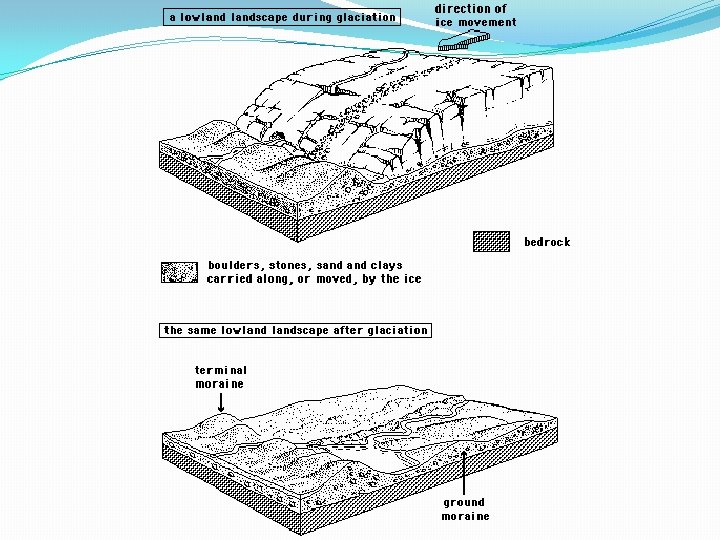
Moraines �Terminal Moraine – Till deposit that marks the furthest advance of the glacier. �Recessional Moraine – Till deposit that marks pauses in the ice fronts retreat Till (moraine)
moraine outwash
Ground Moraine- flat till deposits between recessional moraines Grou nd m Rec essi ona orain e Terminal moraine outwash Rec l mo rain ona e l mo rain e
Other Moraines �Lateral Moraines- These are on the sides of valley/mountain glaciers �Medial Moraines – When two glaciers run along one another/collide these moraines form. �Both are composed of till
Glacial DEPOSITION
MORAINES
Types of Glacial sediment: ERRATICS- • Boulders carried great distance by the glacier • Don’t match surrounding rock
Types of Glacial Sediments (drift) �TILL- unsorted; deposited by ice �STRATIFIED DRIFT- layered (sorted into layers by size); deposited by meltwater streams �OUTWASH- sorted sand; deposited by meltwater