Aircraft Icing and Thunderstorms US Coast Guard Auxiliary


- Slides: 46
Aircraft Icing and Thunderstorms US Coast Guard Auxiliary
Part 1 Icing
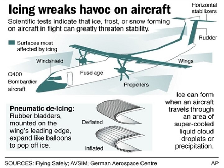
Categories of Icing �Structural Icing � Forms on the surface of the airframe �Induction Icing � Forms in air intakes of engines �Instrument Icing � Forms on pitot tube and other exterior instruments
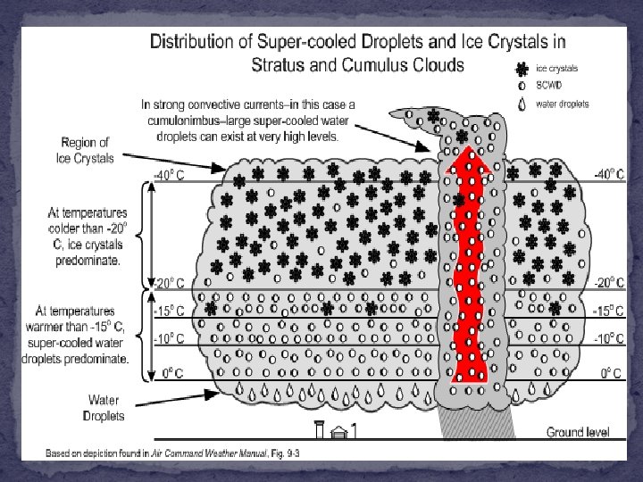
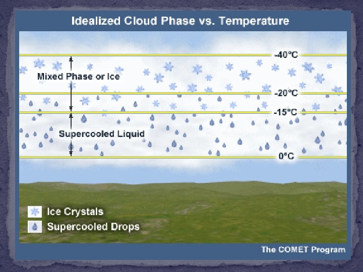
Necessary Conditions � Temperature of 0 Celsius or colder � Supercooled liquid droplets � Liquid cloud or precipitation droplets at below freezing temperatures � Wet snowflakes � Snowflakes at temperatures near 0 C � Mixture of ice particles and supercooled water droplets � When the supercooled liquid hits the airframe, the airframe acts like an ice condensation nuclei and allows the liquid to rapidly freeze
The Cause of Icing �NOT caused by ICE in clouds. �Is caused by “Super-cooled” liquid water droplets � Strike the leading edge of an airfoil � Freeze on impact
Supercooled Droplets – Why do they exist? � Ice Condensation Nuclei typically do not exist at temperatures warmer than -10 C � Ice Condensation Nuclei levels are present at 50% between -10 C and -14 C � Ice Condensation Nuclei are present nearly to 100% by -20 C � Several types of clay particles are common ice nuclei, silver iodide is another.
ICING INTENSITIES TRACE PERCEPTIBLE, NO SIGNIFICANT ACCUMULATION LIGHT A - MODERATE - SIGNIFICANT ACCUMULATION FOR SHORTER PERIODS OF FLIGHT SIGNIFICANT ACCUMULATION FOR PROLONGED FLIGHT (OVER 1 HOUR) SEVERE RAPID, DANGEROUS ACCUMULATIONS
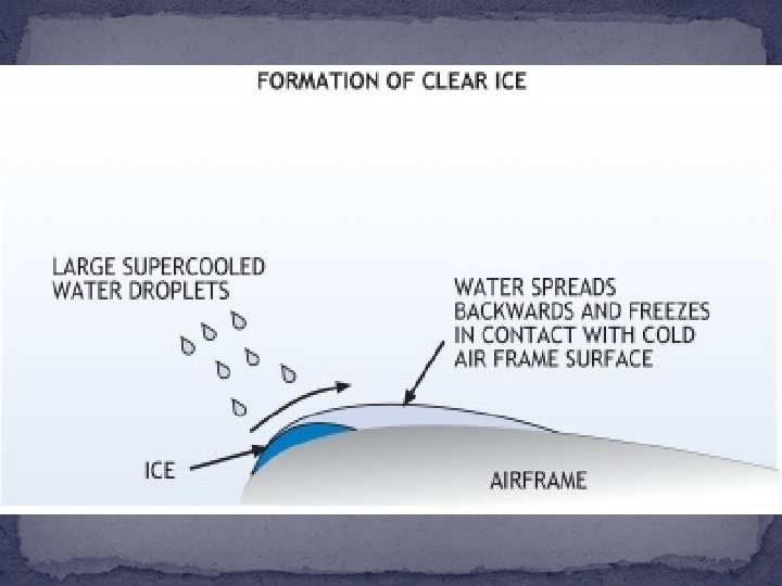
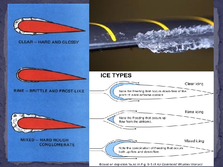
CLEAR ICING FAVORABLE CONDITIONS LARGE DROPLETS IN CUMULIFORM CLOUDS OR FREEZING RAIN TEMPERATURES 0°C TO -20°C
Clear Icing - Characteristics �Rapid accumulation � Droplets are large � Droplets are highly concentrated �Smooth surface �Hard �Difficult to remove
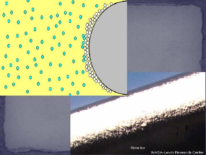
RIME ICING FAVORABLE CONDITIONS SMALL SUPERCOOLED DROPLETS IN STRATIFORM CLOUDS TEMPERATURES 0°C TO -20°C
Rime Icing � White, frosty appearance � Favorable conditions � Small water droplets � Stratiform clouds � Temperatures 0 to -20 C � Formation Process � Droplets freeze on impact � Air is trapped between frozen particles
Rime Icing - Characteristics �Accumulates more slowly than clear icing � Droplets are smaller � Droplets are less concentrated �Irregular, pebble-like surface �Structurally weaker than clear icing � Effect of trapped air
Rime Icing Gray is region where air is stagnant � Tends to form at leading edge of airfoil � More easily for de-icing equipment to remove Rime • Compare with “horns” of Clear icing Clear
MIXED ICING FAVORABLE CONDITIONS LARGE AND SMALL DROPLETS COEXIST LIQUID AND FROZEN PARTICLES COEXIST WET SNOW FREEZING TEMPERATURES
Mixed Icing � Glossy white appearance � Associated with strong upward motion � Favorable conditions � Large and small droplets coexist � Liquid and frozen particles coexist � Wet snow � Freezing temperatures (Often much colder than -10 C) � Formation Process � Combines clear and rime icing processes and/or wet snowflakes
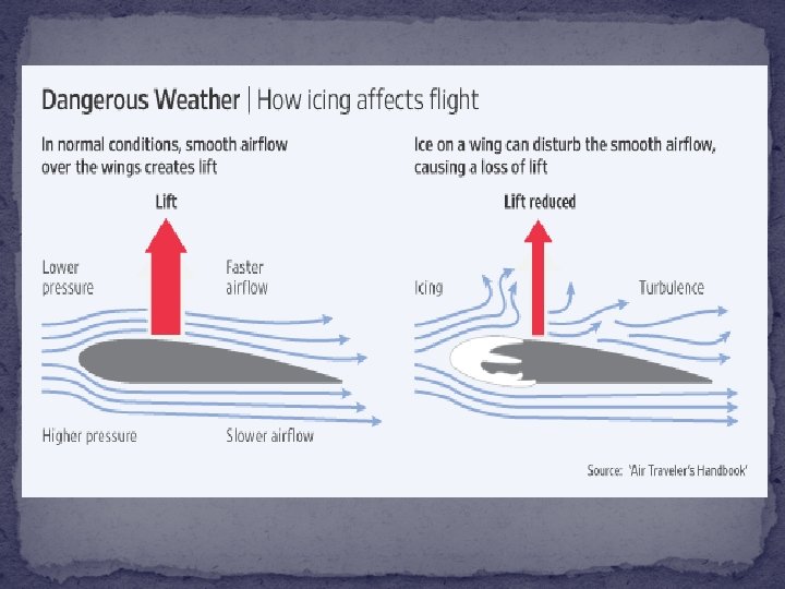
Mixed Icing - Characteristics �Rapid accumulation � Particles are large � Particles are highly concentrated �Rough surface � Creates turbulent flow over wing � Most effective in reducing aerodynamic efficiency (turbulent flow over wing reduces lift) � Difficult to remove
Part 2 Thunderstorms
The Dangers in and Near Thunderstorms �Wind shear �Turbulence �Icing �Lightning �Hail
TURBULENCE and WIND SHEAR CAT BLOWOFF ROLL CLOUD WIND SHEAR TURBULENCE FIRST GUST
GUST FRONT
STORM DIRECTION Cb Cb First gust, windshear turbulence, and rapid wind changes up to about 6000’ A. G. L. ROLL CLOUD Clear or possibly wind blown dust within turbulent air. Up to 10 miles. Up to 100 Kts 150 ft. A. G. L.
Ingredients for Thunderstorm Development - Moisture Low and Mid Level Moisture High Humidity
Thunderstorm Ingredients - Instability �Unstable � Heat rises � Moisture Condenses into clouds as air rises � Common with Low Pressure Systems �Stable � Air sinks � Commons with High Pressure Systems
Thunderstorm Ingredients – Source of Lift Warm /Cold Fronts Thunderstorm Outflow Boundaries Lake Breezes
Thunderstorms Ingredients �Varying degrees of the 3 main elements will affect strength of thunderstorms �Additional ingredients that affect strength of thunderstorms include � Wind Shear � Location of Jet Streams � Large Scale Weather Pattern
Thunderstorm Development – Three Stages �Cumulus �Mature �Dissipation
Basic Thunderstorm Evolution �Rising currents of air are referred to as an Updraft. When combined with sufficient moisture, towering cumulus clouds develop.
Copyright Charles A. Doswell, III
Photo courtesy of Jimmy Deguara Australiasevereweather. com
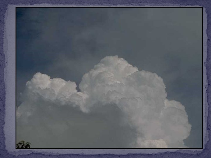
Fair Weather Cumulus – Not Enough Instability or Lift to Generate Thunderstorms
Basic Thunderstorm Evolution � Moisture will condense out of the cloud causing rain, thunder, and lightning. This marks the Mature Stage of the thunderstorms when the updraft and downdraft coexist together.
Basic Thunderstorm Evolution � The downdraft will eventually overcome the updraft, causing the thunderstorm to weaken. The thunderstorm is now in the Dissipation Stage. 40
41
42
Special Types of Thunderstorms � Multi Cell Cluster – These are a family of single cell storms occurring at the same time but in different stages of their lifecycle. � These typically occur in moisture rich unstable environments.
Special Types of Thunderstorms � Multi Cell Line/Squall Line – These are storms organized into a line, often being long lived. � These typically occur in an atmosphere high in instability and wind shear (strengthening winds aloft)
Special Types of Thunderstorms � Super Cell – A long lived single cell storm with a rotating updraft. Typically the strongest of the types. � These occur in an atmosphere high in instability and directional wind shear (strengthening and turning winds aloft)
THE END