Chapter 10 Thunderstorms and Tornadoes What are Thunderstorms
- Slides: 72

Chapter 10 Thunderstorms and Tornadoes

What are Thunderstorms? • A storm containing lightning and thunder • Sometimes produce gusty surface winds, heavy rain and hail • May be a single Cb or several may form a cluster or line • They occur when warm humid air rises in a conditionally unstable environment

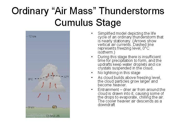
Ordinary “Air Mass” Thunderstorms Cumulus Stage • • • Simplified model depicting the life cycle of an ordinary thunderstorm that is nearly stationary. (Arrows show vertical air currents. Dashed line represents freezing level, 0°C isotherm. ) During this stage there is insufficient time for precipitation to form, and the updrafts keep water droplets and ice crystals suspended in the cloud. No lightning in this stage As cloud builds above freezing level, the cloud particles grow larger and become heavier. Entrainment – drier air from around the cloud is drawn into it, causing some of the drops to evaporate, chilling the air. The cooler heavier air descends as a downdraft

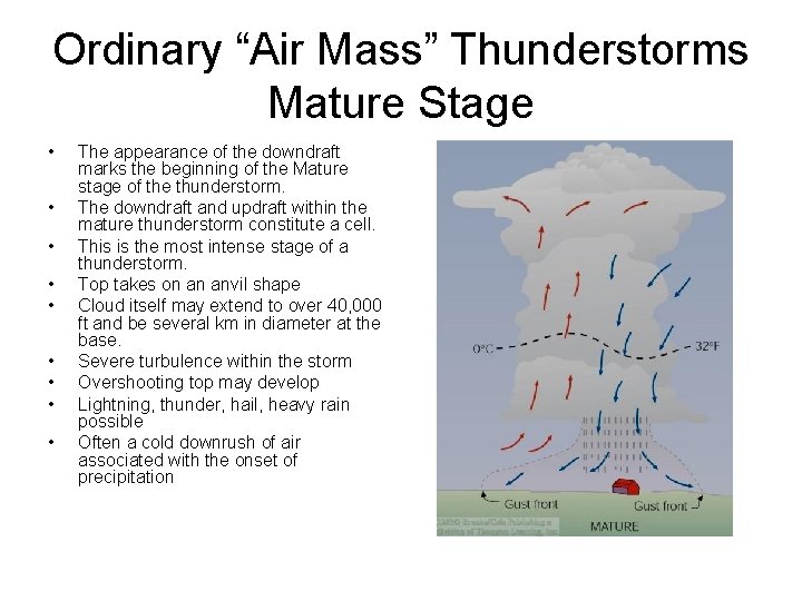
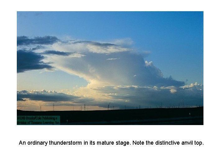
Ordinary “Air Mass” Thunderstorms Mature Stage • • • The appearance of the downdraft marks the beginning of the Mature stage of the thunderstorm. The downdraft and updraft within the mature thunderstorm constitute a cell. This is the most intense stage of a thunderstorm. Top takes on an anvil shape Cloud itself may extend to over 40, 000 ft and be several km in diameter at the base. Severe turbulence within the storm Overshooting top may develop Lightning, thunder, hail, heavy rain possible Often a cold downrush of air associated with the onset of precipitation

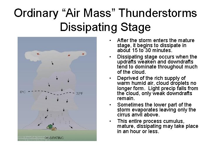
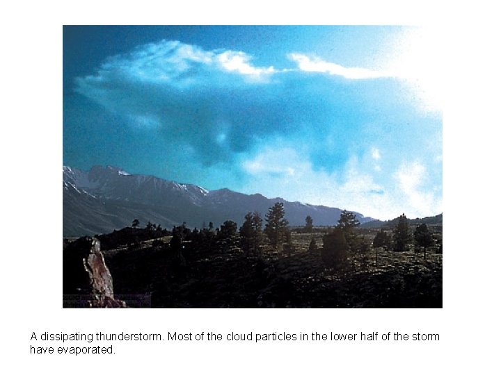
Ordinary “Air Mass” Thunderstorms Dissipating Stage • • • After the storm enters the mature stage, it begins to dissipate in about 15 to 30 minutes. Dissipating stage occurs when the updrafts weaken and downdrafts tend to dominate throughout much of the cloud. Deprived of the rich supply of warm humid air, cloud droplets no longer form. Light precip falls from the cloud, only weak downdrafts remain. Sometimes the lower part of the storm evaporates leaving only the cirrus anvil above. This entire process cumulus, mature, dissipating may take place in an hour or less.

An ordinary thunderstorm in its mature stage. Note the distinctive anvil top.

A dissipating thunderstorm. Most of the cloud particles in the lower half of the storm have evaporated.

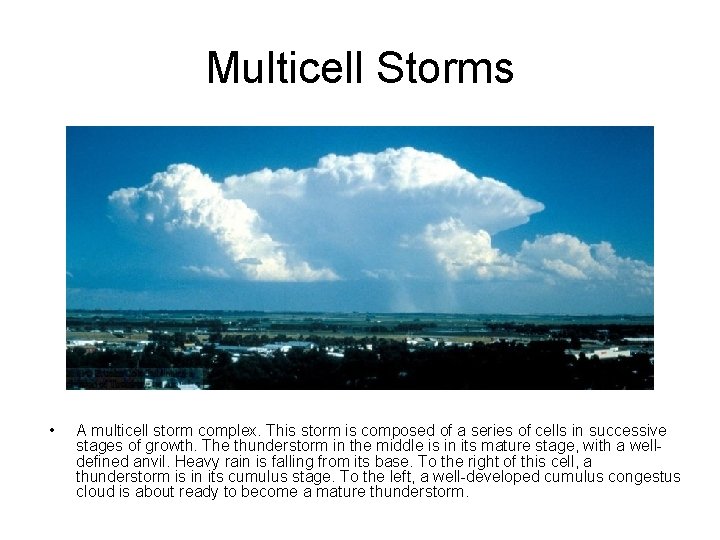
Multicell Storms • A multicell storm complex. This storm is composed of a series of cells in successive stages of growth. The thunderstorm in the middle is in its mature stage, with a welldefined anvil. Heavy rain is falling from its base. To the right of this cell, a thunderstorm is in its cumulus stage. To the left, a well-developed cumulus congestus cloud is about ready to become a mature thunderstorm.

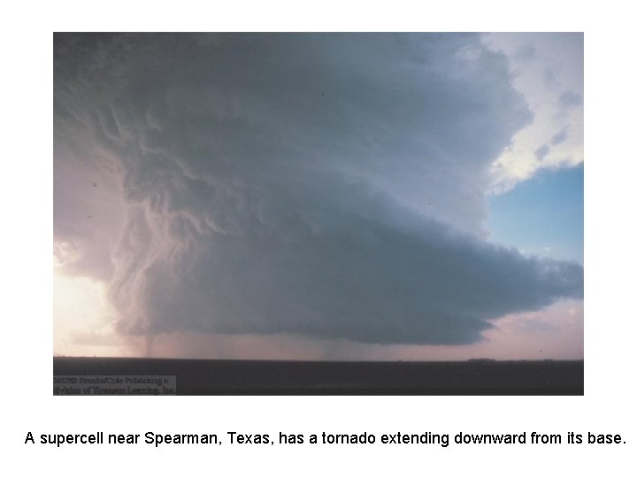
A supercell near Spearman, Texas, has a tornado extending downward from its base.

Severe Thunderstorms • Capable of producing large hail, strong, gusty surface winds, flash floods, and tornadoes. • Form in moist air forced to rise into a conditionally unstable atmosphere. But also form in areas with strong vertical wind shear.

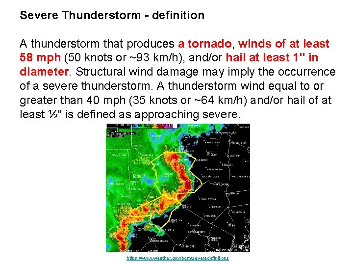
Severe Thunderstorm - definition A thunderstorm that produces a tornado, winds of at least 58 mph (50 knots or ~93 km/h), and/or hail at least 1" in diameter. Structural wind damage may imply the occurrence of a severe thunderstorm. A thunderstorm wind equal to or greater than 40 mph (35 knots or ~64 km/h) and/or hail of at least ½" is defined as approaching severe. https: //www. weather. gov/bgm/severedefinitions

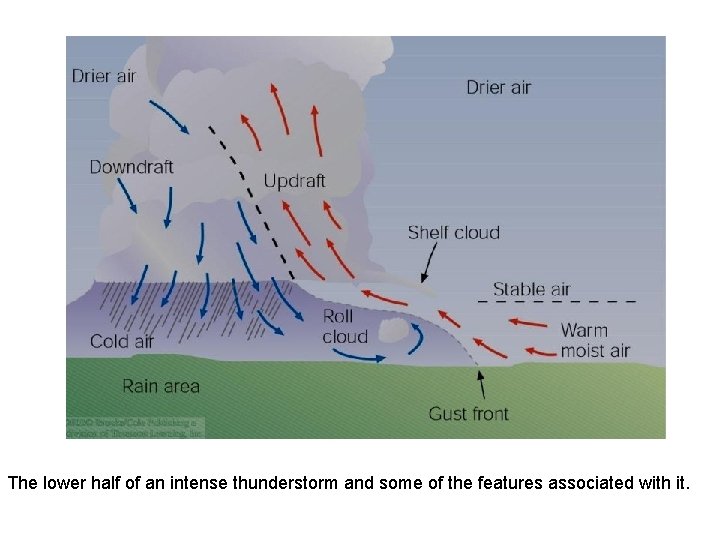
The lower half of an intense thunderstorm and some of the features associated with it.

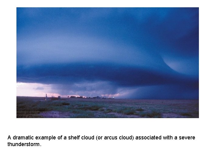
A dramatic example of a shelf cloud (or arcus cloud) associated with a severe thunderstorm.

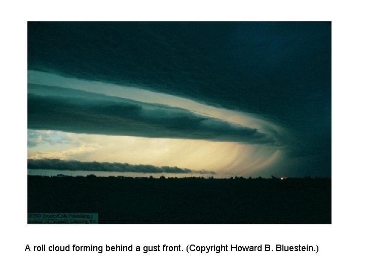
Gust Fronts and roll clouds • Gust front – the boundary separating the cold downdraft of a thunderstorm from the warm surface air. An observer on the ground might mistake the gust front for the passage of a cold front in that the wind often shift, gusts can exceed 55 kts and the temperature drops sharply and pressure often rises. • Roll cloud – occasionally an elongated ominous looking cloud forms just behind the gust front. These clouds, which appear to slowly spin about a horizontal axis are called roll clouds.

A roll cloud forming behind a gust front. (Copyright Howard B. Bluestein. )

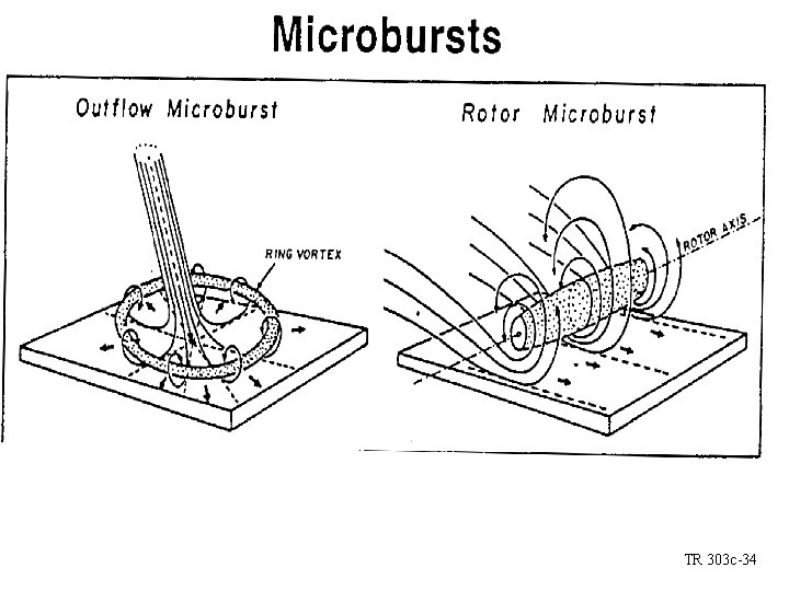
Microbursts • Beneath a severe thunderstorm, the downdraft may become localized so that it hits the ground and spreads horizontally in a radial burst of wind – such downdrafts are called downbursts. • A downburst with winds extending only 4 kilometers or less is termed a microburst. An intense microburst can induce damaging winds as high as 146 kts.

Damage from straight line winds Tornado like (shear) vortices along leading edge can inflict damage Low level wind shear TR 303 c-34

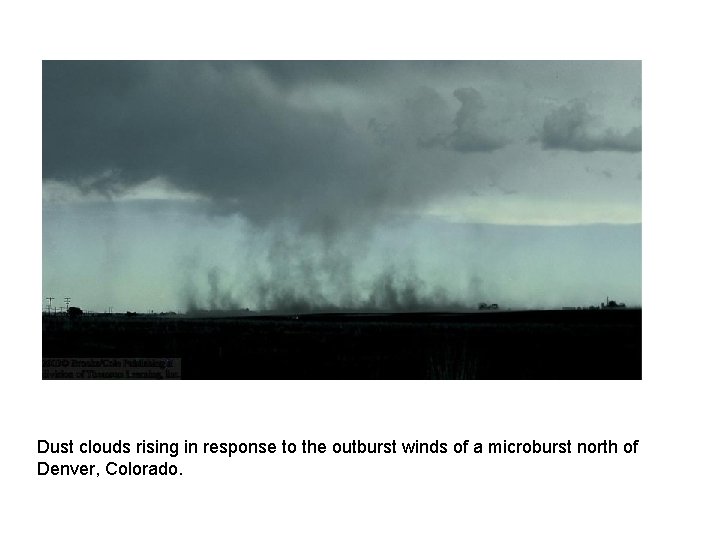
Dust clouds rising in response to the outburst winds of a microburst north of Denver, Colorado.

Derecho • Strong downburst winds associated with a cluster of severe thunderstorms can produce damaging straight-line-winds that may exceed 90 kts. If the wind damage extends for at least 400 km along the storm’s path, the winds are called a derecho (day-ray-cho). • Most derechos form in the early evening and are associated with severe thunderstorms that extend outward in the shape of a bow echo on a radar screen.

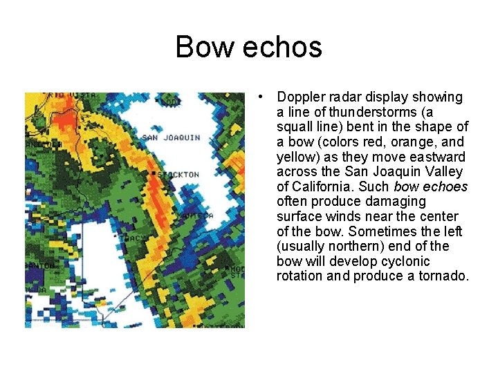
Bow echos • Doppler radar display showing a line of thunderstorms (a squall line) bent in the shape of a bow (colors red, orange, and yellow) as they move eastward across the San Joaquin Valley of California. Such bow echoes often produce damaging surface winds near the center of the bow. Sometimes the left (usually northern) end of the bow will develop cyclonic rotation and produce a tornado.

Supercell and Squall line Thunderstorms • Supercell storm – an enormous rotating thunderstorm whose updrafts and downdrafts are sufficiently structured so that it is able to maintain itself as a single entity for hours on end. Can produce updrafts in excess of 90 kts, hail the size of grapefruit, damaging surface winds and large long-lasting tornadoes.

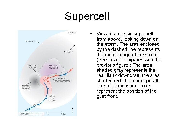
Supercell • View of a classic supercell from above, looking down on the storm. The area enclosed by the dashed line represents the radar image of the storm. (See how it compares with the previous figure. ) The area shaded gray represents the rear flank downdraft; the area shaded red, the main updraft. The cold and warm fronts represent the position of the gust front.

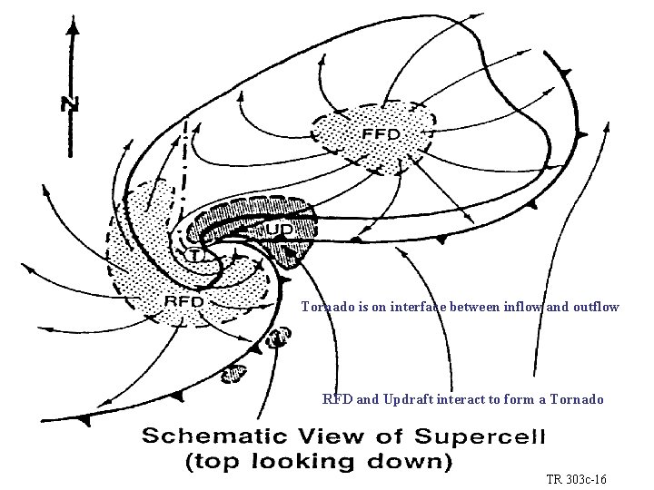
Tornado is on interface between inflow and outflow RFD and Updraft interact to form a Tornado TR 303 c-16

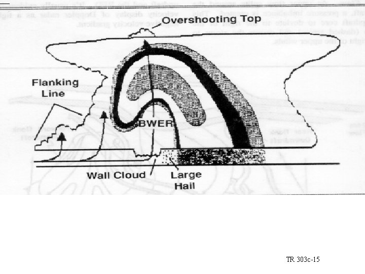
Bounded Weak Echo Region caused by intense updrafts (precip forms higher) Largest hail falls to left of wall cloud Funnel clouds are common with wall cloud TR 303 c-15

Squall Line • The squall-line forms as a line of thunderstorms. “A line of thunderstorms that form along a cold front or out ahead of it. ” • Can from as much as 100 to 300 km out ahead of a cold front in the warm air. • Pre-frontal squall line thunderstorms of the middle latitudes represent the largest and most severe type of squall line.

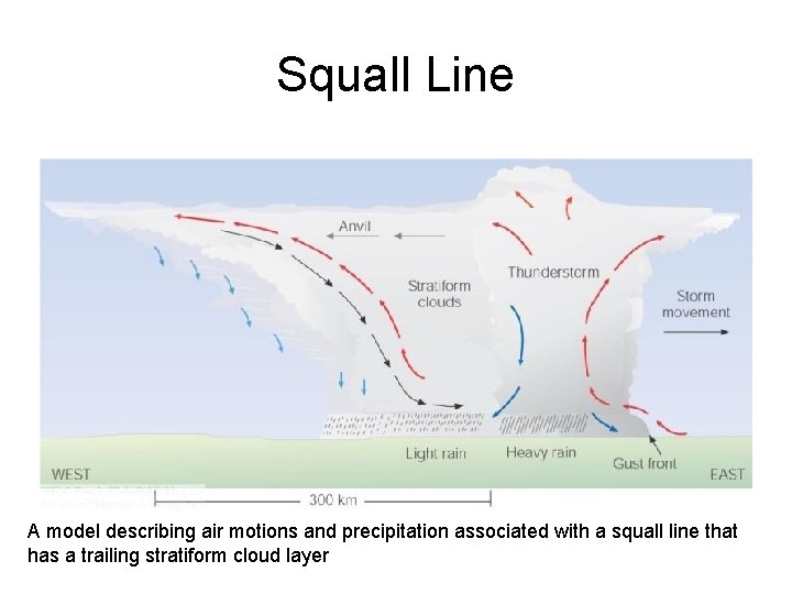
Squall Line A model describing air motions and precipitation associated with a squall line that has a trailing stratiform cloud layer

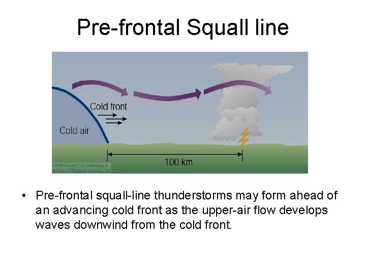
Pre-frontal Squall line • Pre-frontal squall-line thunderstorms may form ahead of an advancing cold front as the upper-air flow develops waves downwind from the cold front.

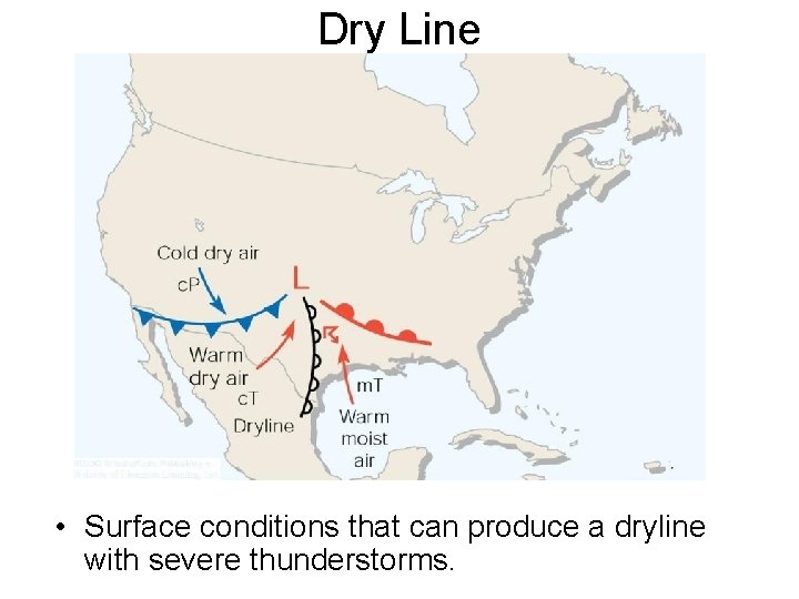
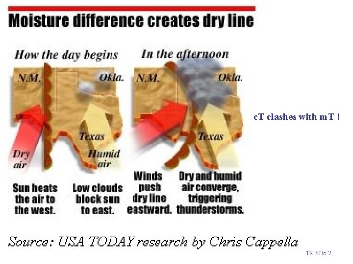
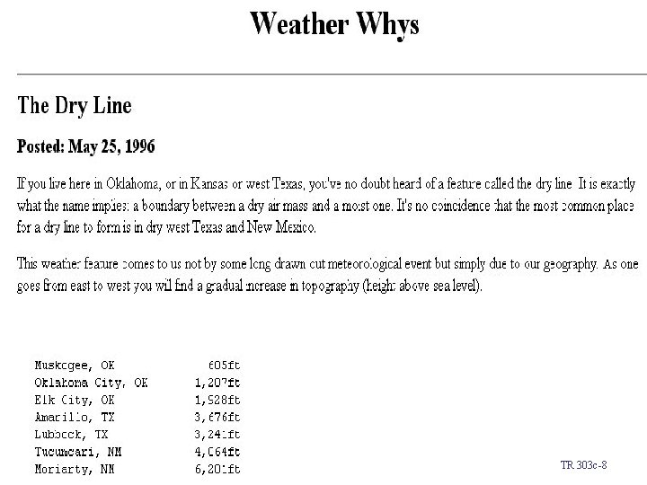
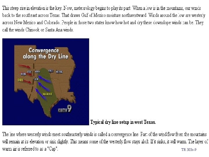
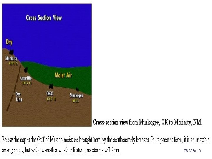
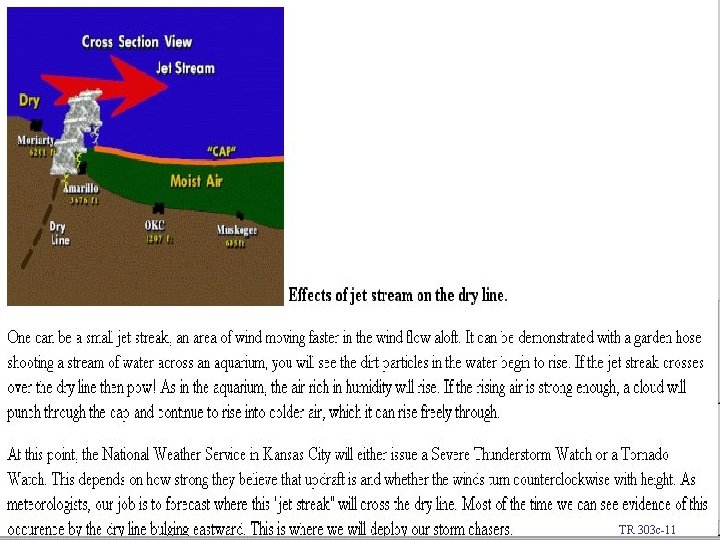
Severe Thunderstorms and the Dryline • Severe thunderstorms may form along or just east of a boundary called a dry line. • The dryline represents a narrow zone where there is a sharp horizontal change in moisture. • Because dew-point temperatures may drop along this boundary by as much as 9°C (16°F) per km dry lines have been referred to as dewpoint fronts. • Most frequently observed in western half of Texas, Oklahoma and Kansas in the spring and early summer.

Dry Line • Surface conditions that can produce a dryline with severe thunderstorms.

c. T clashes with m. T ! TR 303 c-7

TR 303 c-8

TR 303 c-9

TR 303 c-10

TR 303 c-11

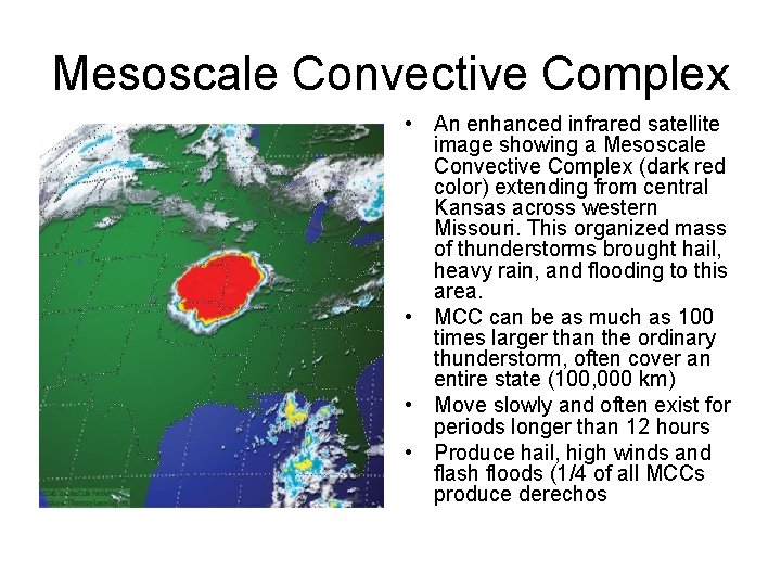
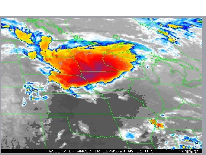
Mesoscale Convective Complex • An enhanced infrared satellite image showing a Mesoscale Convective Complex (dark red color) extending from central Kansas across western Missouri. This organized mass of thunderstorms brought hail, heavy rain, and flooding to this area. • MCC can be as much as 100 times larger than the ordinary thunderstorm, often cover an entire state (100, 000 km) • Move slowly and often exist for periods longer than 12 hours • Produce hail, high winds and flash floods (1/4 of all MCCs produce derechos

Galva, IA Tornado TR 303 c-37

MCC – How is it formed? • Form during the summer in regions where the upper-level winds are weak, often beneath a ridge of high pressure. • A weak cold front may stall beneath the ridge, surface heating and moisture may be sufficient to generate thunderstorms on the cool side of the front. • Moisture from the south is brought into the system by a low level jet stream.

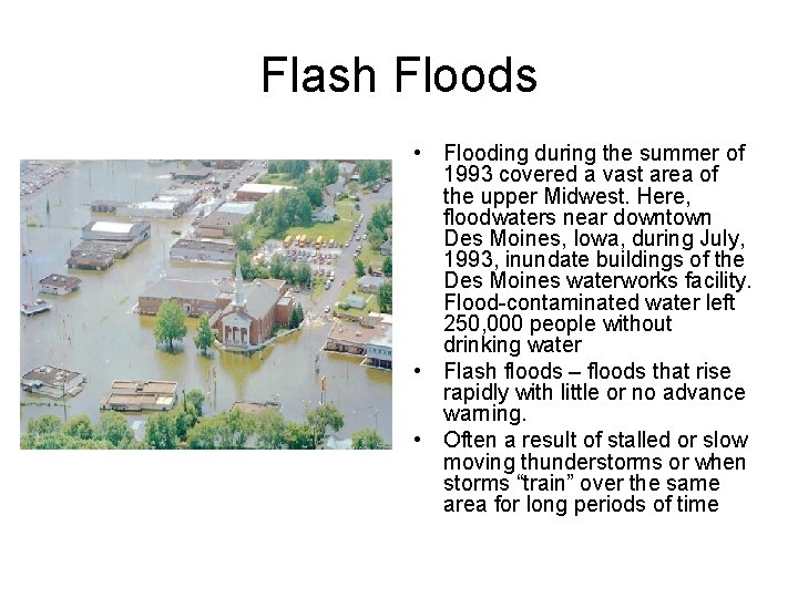
Flash Floods • Flooding during the summer of 1993 covered a vast area of the upper Midwest. Here, floodwaters near downtown Des Moines, Iowa, during July, 1993, inundate buildings of the Des Moines waterworks facility. Flood-contaminated water left 250, 000 people without drinking water • Flash floods – floods that rise rapidly with little or no advance warning. • Often a result of stalled or slow moving thunderstorms or when storms “train” over the same area for long periods of time

Flash Floods • Heavy rains due to • Associated with regenerative intense synoptic scale convective storms cyclone or frontal system • High surface dewpoints • A quasi-stationary front over area • Winds aloft are weak; thunderstorms stall or • Winds aloft parallel to move slowly front TR 303 c-36

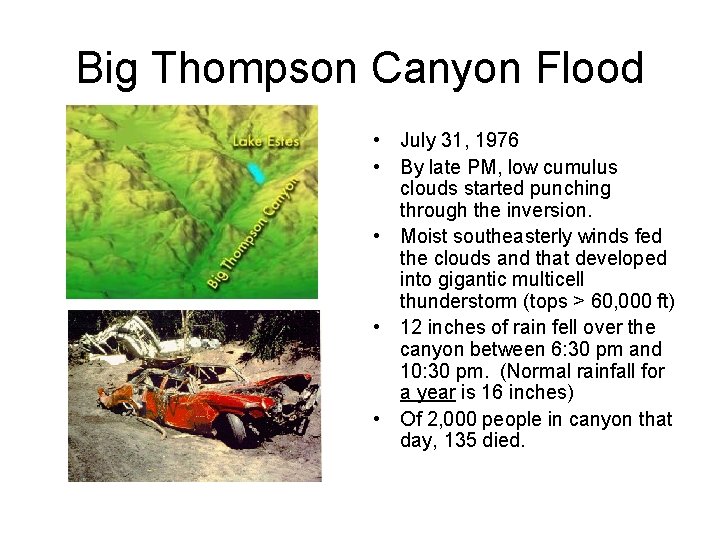
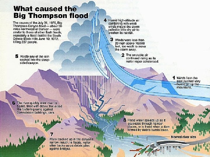
Big Thompson Canyon Flood • July 31, 1976 • By late PM, low cumulus clouds started punching through the inversion. • Moist southeasterly winds fed the clouds and that developed into gigantic multicell thunderstorm (tops > 60, 000 ft) • 12 inches of rain fell over the canyon between 6: 30 pm and 10: 30 pm. (Normal rainfall for a year is 16 inches) • Of 2, 000 people in canyon that day, 135 died.


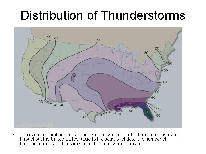
Distribution of Thunderstorms • The average number of days each year on which thunderstorms are observed throughout the United States. (Due to the scarcity of data, the number of thunderstorms is underestimated in the mountainous west. )

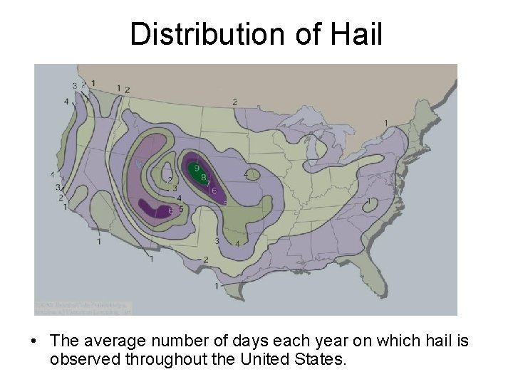
Distribution of Hail • The average number of days each year on which hail is observed throughout the United States.

Lightning and Thunder • Lightning – simply a discharge of electricity, a giant spark, which occurs in mature thunderstorms. • Lightning can take place in cloud, cloud to air, and cloud to ground. • Thunder – the sound due to rapidly expanding gases along the channel of a lightning discharge. • Thunder travels about I mile in 5 seconds. If we see lightning and then hear thunder 15 seconds later, the stroke occurred about 3 miles away. • Sonic Boom – sound produced when aircraft exceeds the speed of sound at the altitude at which it is flying. Aircraft compresses the air, forming a shock wave, air pressure changes rapidly over a short distance, the rapid change of air pressure causes the sonic boom.

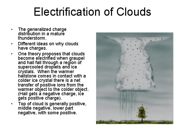
Electrification of Clouds • • The generalized charge distribution in a mature thunderstorm. Different ideas on why clouds have charges. One theory proposes that clouds become electrified when graupel and hail fall through a region of supercooled droplets and ice crystals. When the warmer hailstone comes in contact with a colder ice crystal there is a net transfer of positive ions from the warmer object to the colder object. (Hail gets a negative charge, ice gets positive charge). Top of cloud is generally positive, middle negative, lower part negative, with some positive.

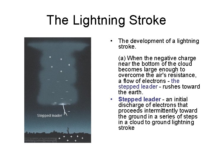
The Lightning Stroke • The development of a lightning stroke. (a) When the negative charge near the bottom of the cloud becomes large enough to overcome the air's resistance, a flow of electrons - the stepped leader - rushes toward the earth. • Stepped leader - an initial discharge of electrons that proceeds intermittently toward the ground in a series of steps in a cloud to ground lightning stroke

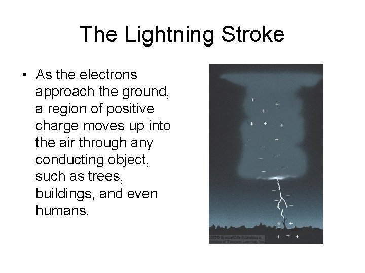
The Lightning Stroke • As the electrons approach the ground, a region of positive charge moves up into the air through any conducting object, such as trees, buildings, and even humans.

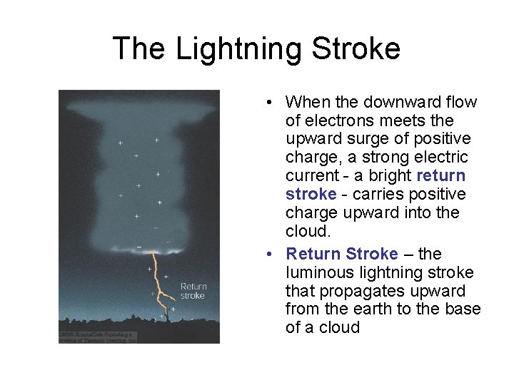
The Lightning Stroke • When the downward flow of electrons meets the upward surge of positive charge, a strong electric current - a bright return stroke - carries positive charge upward into the cloud. • Return Stroke – the luminous lightning stroke that propagates upward from the earth to the base of a cloud

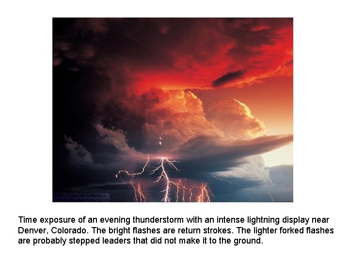
Time exposure of an evening thunderstorm with an intense lightning display near Denver, Colorado. The bright flashes are return strokes. The lighter forked flashes are probably stepped leaders that did not make it to the ground.

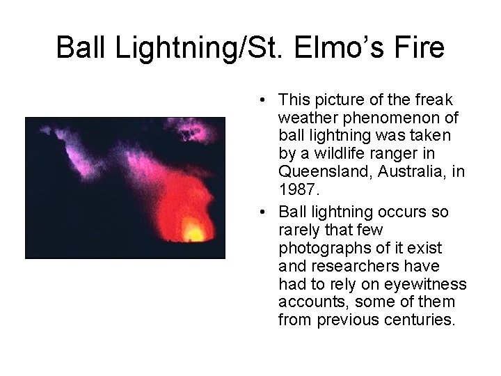
More lightning terms • Dart leader – the discharge of electrons that proceeds intermittently toward the ground along the same ionized channel taken by the initial lightning stroke. • Heat lightning – distant lightning from thunderstorms that is seen but not heard. So called because it frequently occurs on hot summer nights when the sky overhead is clear. • St. Elmo’s Fire – named after the patron saint of sailors. A bright electric discharge that is projected from objects (usually pointed) when they are in a strong electric field such as during a thunderstorm.

Ball Lightning/St. Elmo’s Fire • This picture of the freak weather phenomenon of ball lightning was taken by a wildlife ranger in Queensland, Australia, in 1987. • Ball lightning occurs so rarely that few photographs of it exist and researchers have had to rely on eyewitness accounts, some of them from previous centuries.

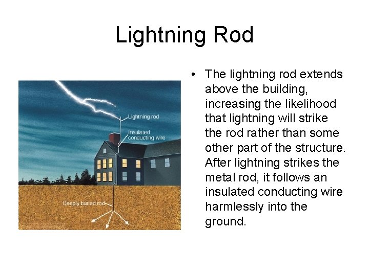
Lightning Rod • The lightning rod extends above the building, increasing the likelihood that lightning will strike the rod rather than some other part of the structure. After lightning strikes the metal rod, it follows an insulated conducting wire harmlessly into the ground.

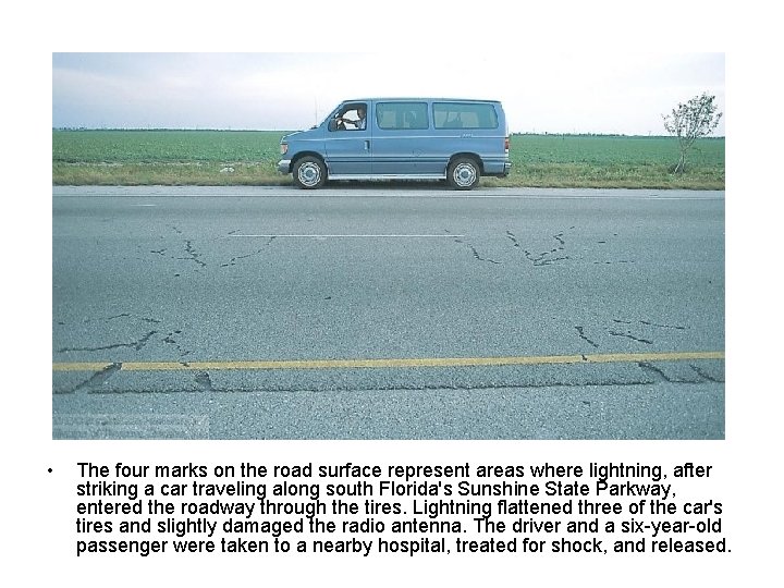
• The four marks on the road surface represent areas where lightning, after striking a car traveling along south Florida's Sunshine State Parkway, entered the roadway through the tires. Lightning flattened three of the car's tires and slightly damaged the radio antenna. The driver and a six-year-old passenger were taken to a nearby hospital, treated for shock, and released.

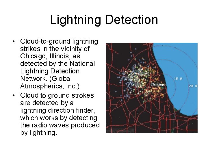
Lightning Detection • Cloud-to-ground lightning strikes in the vicinity of Chicago, Illinois, as detected by the National Lightning Detection Network. (Global Atmospherics, Inc. ) • Cloud to ground strokes are detected by a lightning direction finder, which works by detecting the radio waves produced by lightning.

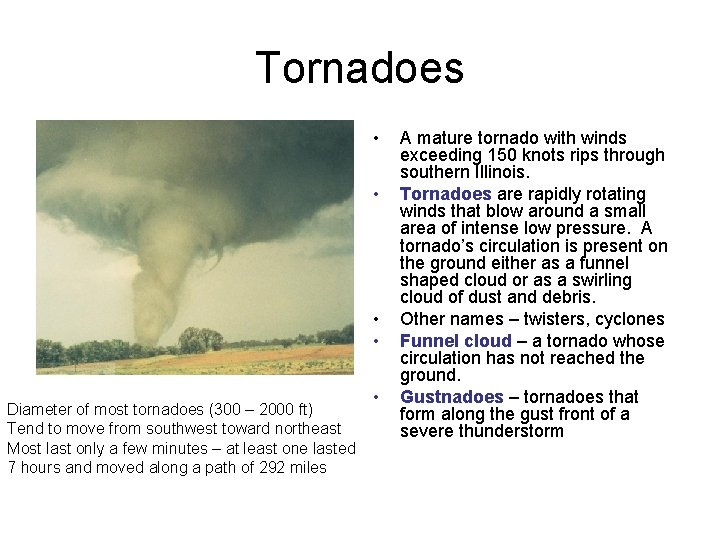
Tornadoes • • Diameter of most tornadoes (300 – 2000 ft) Tend to move from southwest toward northeast Most last only a few minutes – at least one lasted 7 hours and moved along a path of 292 miles • A mature tornado with winds exceeding 150 knots rips through southern Illinois. Tornadoes are rapidly rotating winds that blow around a small area of intense low pressure. A tornado’s circulation is present on the ground either as a funnel shaped cloud or as a swirling cloud of dust and debris. Other names – twisters, cyclones Funnel cloud – a tornado whose circulation has not reached the ground. Gustnadoes – tornadoes that form along the gust front of a severe thunderstorm

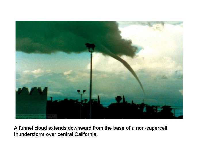
A funnel cloud extends downward from the base of a non-supercell thunderstorm over central California.

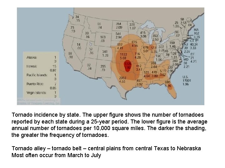
Tornado incidence by state. The upper figure shows the number of tornadoes reported by each state during a 25 -year period. The lower figure is the average annual number of tornadoes per 10, 000 square miles. The darker the shading, the greater the frequency of tornadoes. Tornado alley – tornado belt – central plains from central Texas to Nebraska Most often occur from March to July

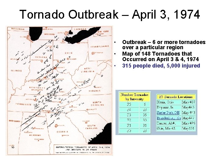
Tornado Outbreak – April 3, 1974 • • • Outbreak – 6 or more tornadoes over a particular region Map of 148 Tornadoes that Occurred on April 3 & 4, 1974 315 people died, 5, 000 injured

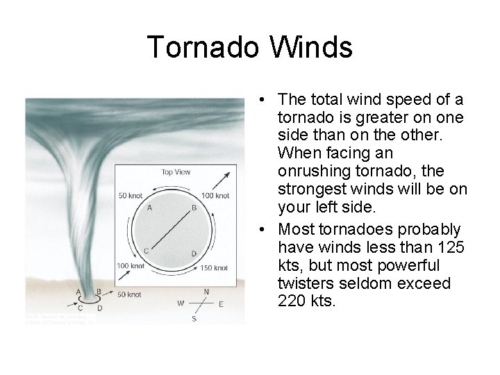
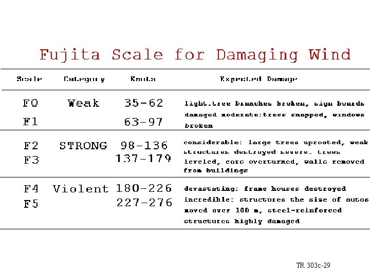
Tornado Winds • The total wind speed of a tornado is greater on one side than on the other. When facing an onrushing tornado, the strongest winds will be on your left side. • Most tornadoes probably have winds less than 125 kts, but most powerful twisters seldom exceed 220 kts.

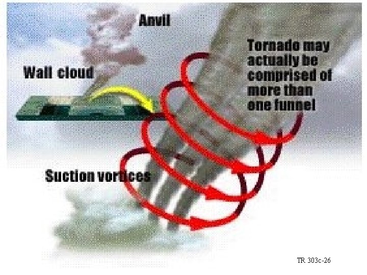
TR 303 c-26

TR 303 c-29

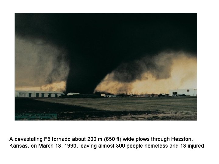
A devastating F 5 tornado about 200 m (650 ft) wide plows through Hesston, Kansas, on March 13, 1990, leaving almost 300 people homeless and 13 injured.

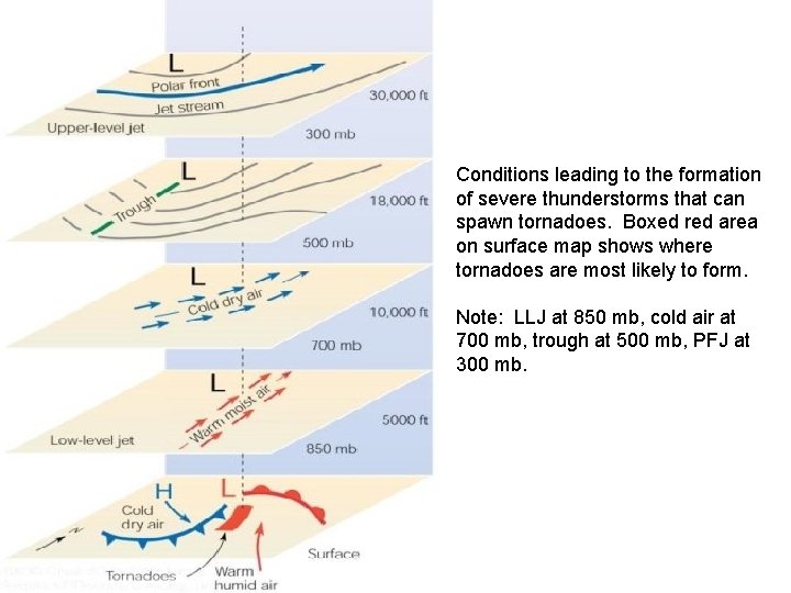
Conditions leading to the formation of severe thunderstorms that can spawn tornadoes. Boxed red area on surface map shows where tornadoes are most likely to form. Note: LLJ at 850 mb, cold air at 700 mb, trough at 500 mb, PFJ at 300 mb.

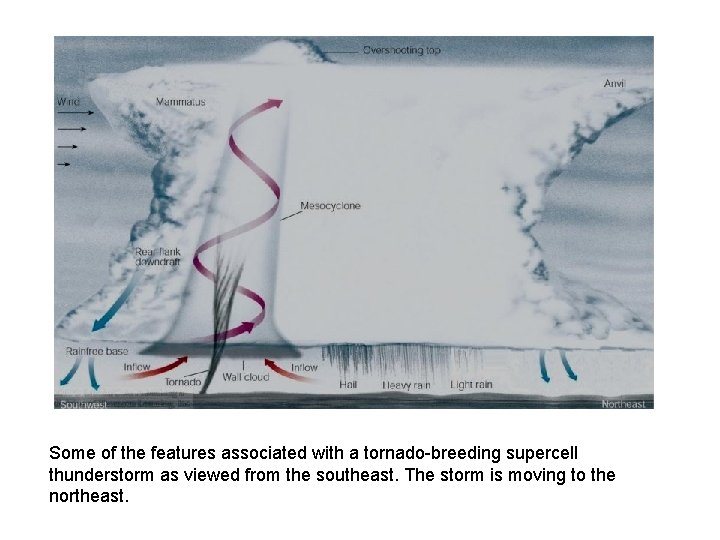
Some of the features associated with a tornado-breeding supercell thunderstorm as viewed from the southeast. The storm is moving to the northeast.

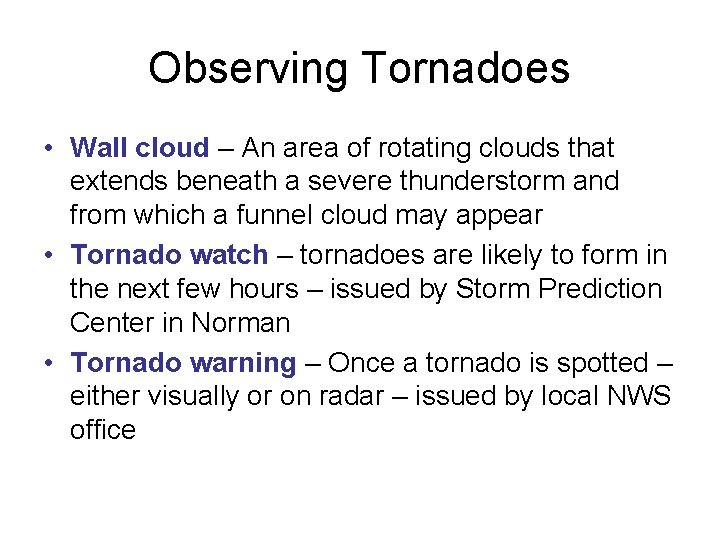
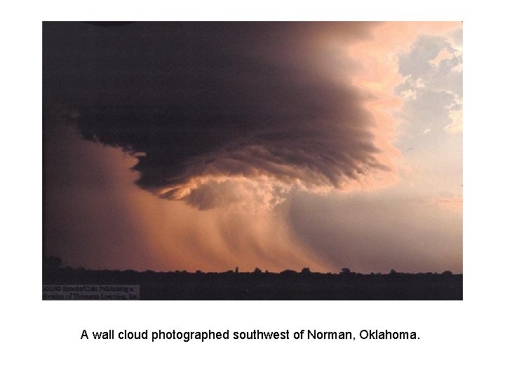
Observing Tornadoes • Wall cloud – An area of rotating clouds that extends beneath a severe thunderstorm and from which a funnel cloud may appear • Tornado watch – tornadoes are likely to form in the next few hours – issued by Storm Prediction Center in Norman • Tornado warning – Once a tornado is spotted – either visually or on radar – issued by local NWS office

A wall cloud photographed southwest of Norman, Oklahoma.

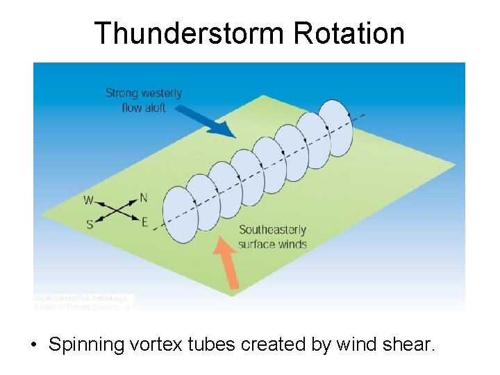
Thunderstorm Rotation • Spinning vortex tubes created by wind shear.

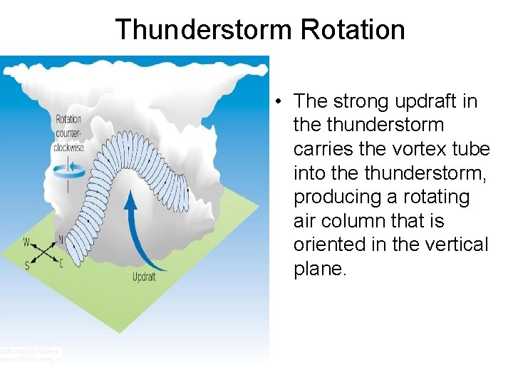
Thunderstorm Rotation • The strong updraft in the thunderstorm carries the vortex tube into the thunderstorm, producing a rotating air column that is oriented in the vertical plane.

Doppler Radar • Similar to a conventional radar in that is can detect areas of precipitation and measure rainfall intensity. • Doppler can do more – actually measures the speed at which precipitation is moving horizontally toward or away from the radar antenna. • Doppler radar “peers into severe thunderstorms and reveals its winds.

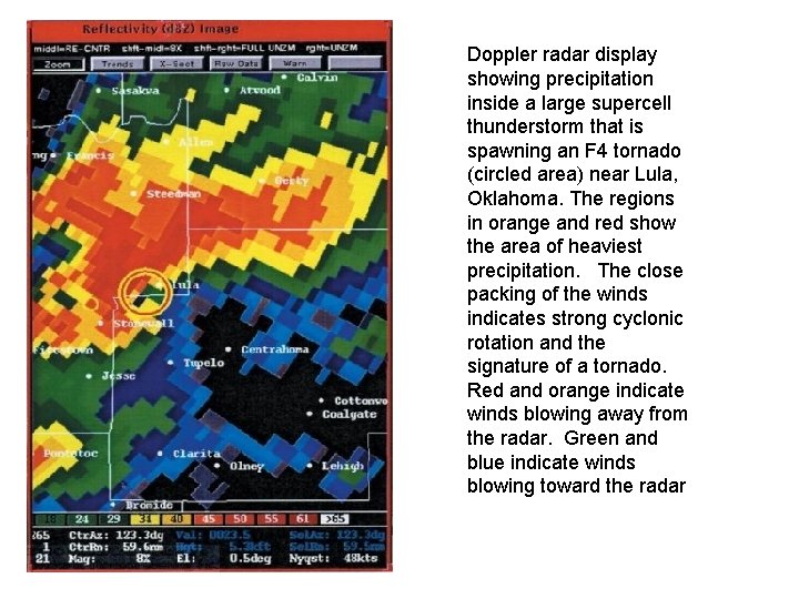
Doppler radar display showing precipitation inside a large supercell thunderstorm that is spawning an F 4 tornado (circled area) near Lula, Oklahoma. The regions in orange and red show the area of heaviest precipitation. The close packing of the winds indicates strong cyclonic rotation and the signature of a tornado. Red and orange indicate winds blowing away from the radar. Green and blue indicate winds blowing toward the radar

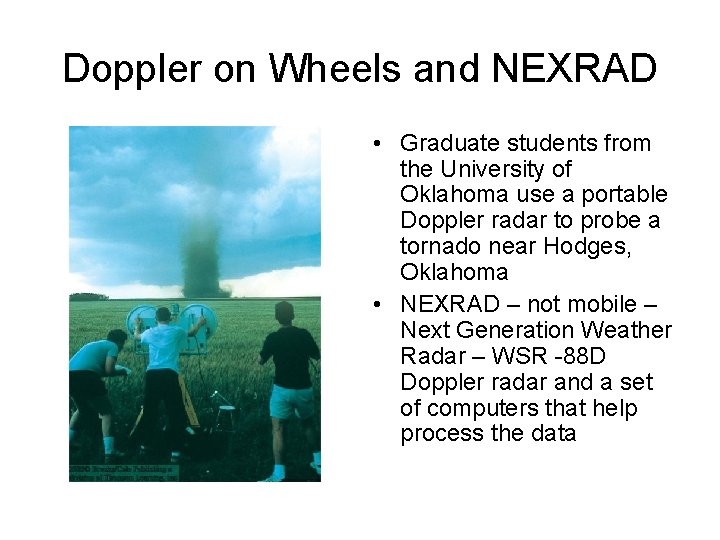
Doppler on Wheels and NEXRAD • Graduate students from the University of Oklahoma use a portable Doppler radar to probe a tornado near Hodges, Oklahoma • NEXRAD – not mobile – Next Generation Weather Radar – WSR -88 D Doppler radar and a set of computers that help process the data

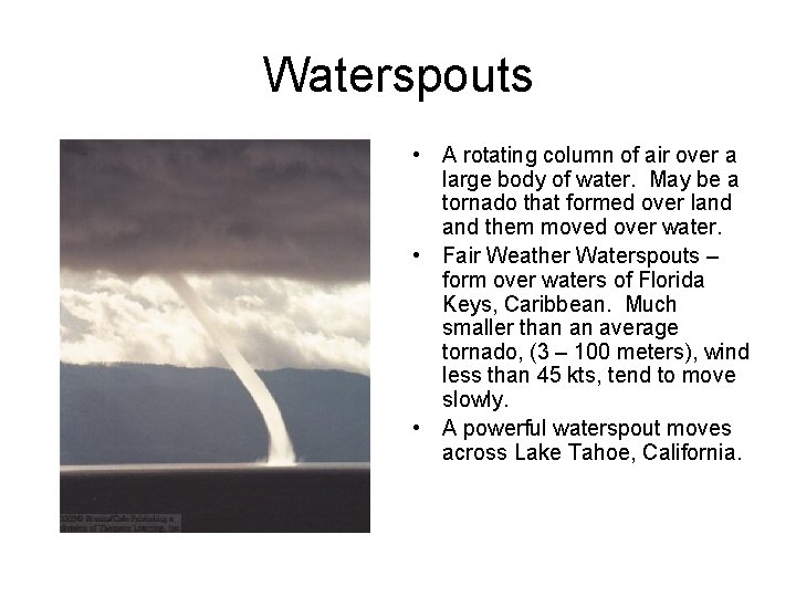
Waterspouts • A rotating column of air over a large body of water. May be a tornado that formed over land them moved over water. • Fair Weather Waterspouts – form over waters of Florida Keys, Caribbean. Much smaller than an average tornado, (3 – 100 meters), wind less than 45 kts, tend to move slowly. • A powerful waterspout moves across Lake Tahoe, California.