Regional Numerical Weather Prediction NWP Modeling and Verification
![SPo. RT Work with SMAP [and SMOS] • L-band radiometers (and radars) can Soil SPo. RT Work with SMAP [and SMOS] • L-band radiometers (and radars) can Soil](https://slidetodoc.com/presentation_image_h2/8a36573c1a1fe594246af232a2255bb1/image-18.jpg)

- Slides: 29

Regional Numerical Weather Prediction (NWP) Modeling and Verification Workshop Part 3: Background on NASA Tools and Missions to Improve Land Surface Properties: [a] Land Information System (LIS) [b] Global Precipitation Measurement (GPM) [c] Visible Infrared Imaging Radiometer Suite (VIIRS) Green Vegetation Fraction (GVF) [d] Data Assimilation with Soil Moisture Active Passive (SMAP) Jonathan Case (ENSCO, Inc. /NASA Short-term Prediction Research and Transition [SPo. RT] Center)

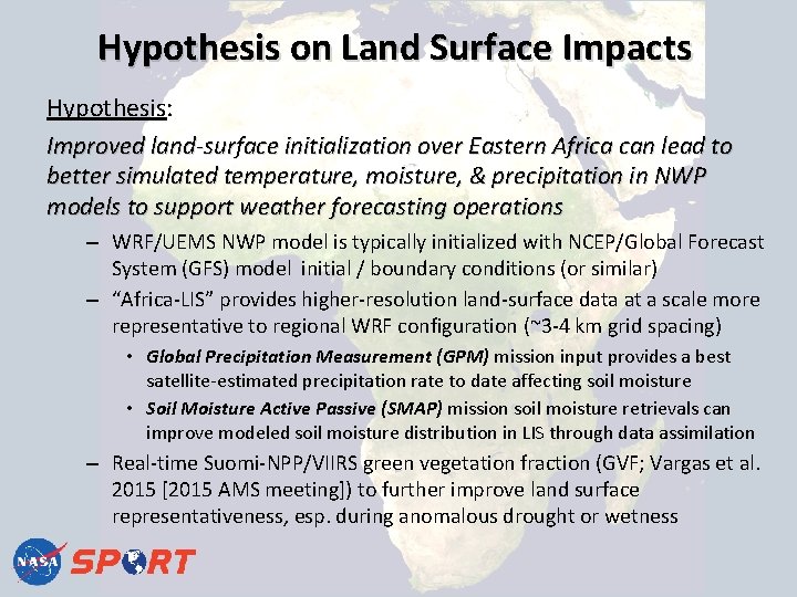
Hypothesis on Land Surface Impacts Hypothesis: Improved land-surface initialization over Eastern Africa can lead to better simulated temperature, moisture, & precipitation in NWP models to support weather forecasting operations – WRF/UEMS NWP model is typically initialized with NCEP/Global Forecast System (GFS) model initial / boundary conditions (or similar) – “Africa-LIS” provides higher-resolution land-surface data at a scale more representative to regional WRF configuration (~3 -4 km grid spacing) • Global Precipitation Measurement (GPM) mission input provides a best satellite-estimated precipitation rate to date affecting soil moisture • Soil Moisture Active Passive (SMAP) mission soil moisture retrievals can improve modeled soil moisture distribution in LIS through data assimilation – Real-time Suomi-NPP/VIIRS green vegetation fraction (GVF; Vargas et al. 2015 [2015 AMS meeting]) to further improve land surface representativeness, esp. during anomalous drought or wetness

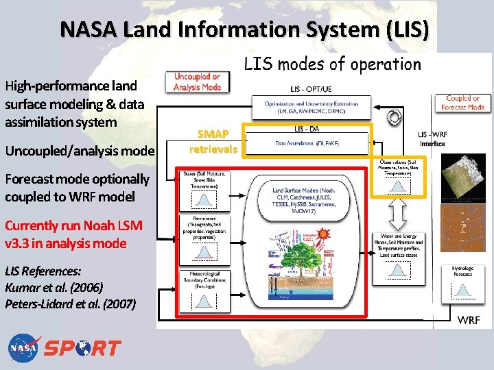
NASA Land Information System (LIS) High-performance land surface modeling & data assimilation system Uncoupled/analysis mode Forecast mode optionally coupled to WRF model Currently run Noah LSM v 3. 3 in analysis mode LIS References: Kumar et al. (2006) Peters-Lidard et al. (2007) SMAP retrievals

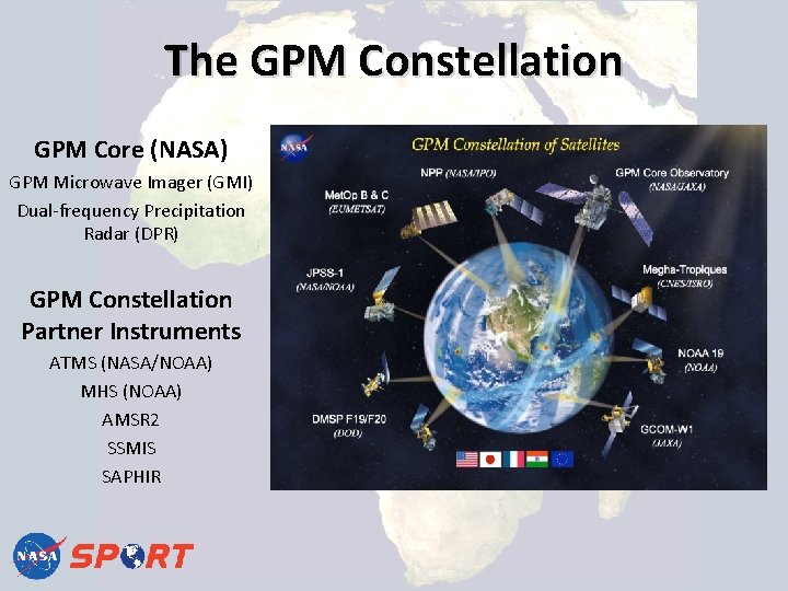
The GPM Constellation GPM Core (NASA) GPM Microwave Imager (GMI) Dual-frequency Precipitation Radar (DPR) GPM Constellation Partner Instruments ATMS (NASA/NOAA) MHS (NOAA) AMSR 2 SSMIS SAPHIR

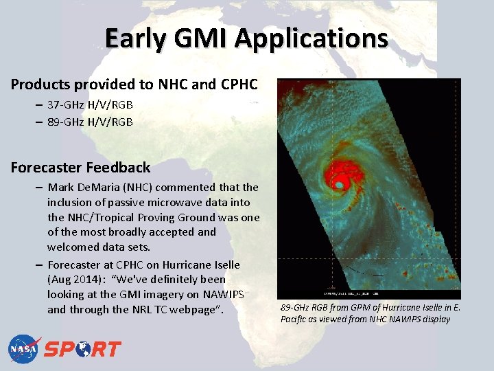
Early GMI Applications Products provided to NHC and CPHC – 37 -GHz H/V/RGB – 89 -GHz H/V/RGB Forecaster Feedback – Mark De. Maria (NHC) commented that the inclusion of passive microwave data into the NHC/Tropical Proving Ground was one of the most broadly accepted and welcomed data sets. – Forecaster at CPHC on Hurricane Iselle (Aug 2014): “We've definitely been looking at the GMI imagery on NAWIPS and through the NRL TC webpage”. 89 -GHz RGB from GPM of Hurricane Iselle in E. Pacific as viewed from NHC NAWIPS display

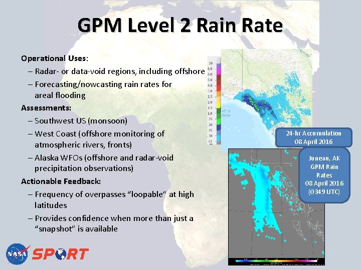
GPM Level 2 Rain Rate Operational Uses: Radar- or data-void regions, including offshore Forecasting/nowcasting rain rates for areal flooding Assessments: Southwest US (monsoon) West Coast (offshore monitoring of atmospheric rivers, fronts) Alaska WFOs (offshore and radar-void precipitation observations) Actionable Feedback: Frequency of overpasses “loopable” at high latitudes Provides confidence when more than just a “snapshot” is available 24 -hr Accumulation 08 April 2016 Juneau, AK GPM Rain Rates 08 April 2016 (0349 UTC)

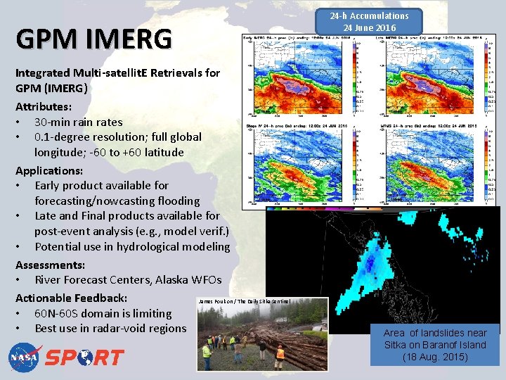
GPM IMERG Integrated Multi-satellit. E Retrievals for GPM (IMERG) Attributes: • 30 -min rates • 0. 1 -degree resolution; full global longitude; -60 to +60 latitude Applications: • Early product available forecasting/nowcasting flooding • Late and Final products available for post-event analysis (e. g. , model verif. ) • Potential use in hydrological modeling Assessments: • River Forecast Centers, Alaska WFOs Actionable Feedback: James Poulson / The Daily Sitka Sentinel • 60 N-60 S domain is limiting • Best use in radar-void regions 24 -h Accumulations 24 June 2016 Area of landslides near Sitka on Baranof Island (18 Aug. 2015)

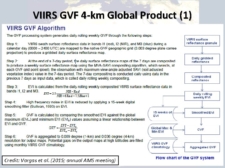
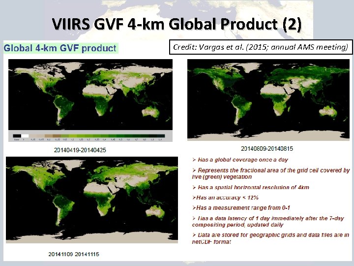
Real-time Suomi-NPP/VIIRS Green Vegetation Fraction (GVF) in models • Operational models (GFS/NAM/NLDAS) still use monthly climatologies to depict vegetation • SPo. RT developed an in-house daily 1 -km MODIS GVF over the CONUS for use in both LIS and WRF model – Case et al. (2014) IEEE TGRS article highlighted impacts on offline Noah LSM and WRF model simulations – Incorporated into SPo. RT-LIS runs since 2012 • NOAA/NESDIS now produces daily, real-time 4 -km VIIRS GVF on global scale (available Sep 2012 to present) – Switched to this product for LIS applications in 2015 – Good temporal continuity while capturing greenness anomalies

VIIRS GVF 4 -km Global Product (1) Credit: Vargas et al. (2015; annual AMS meeting)

VIIRS GVF 4 -km Global Product (2) Credit: Vargas et al. (2015; annual AMS meeting)

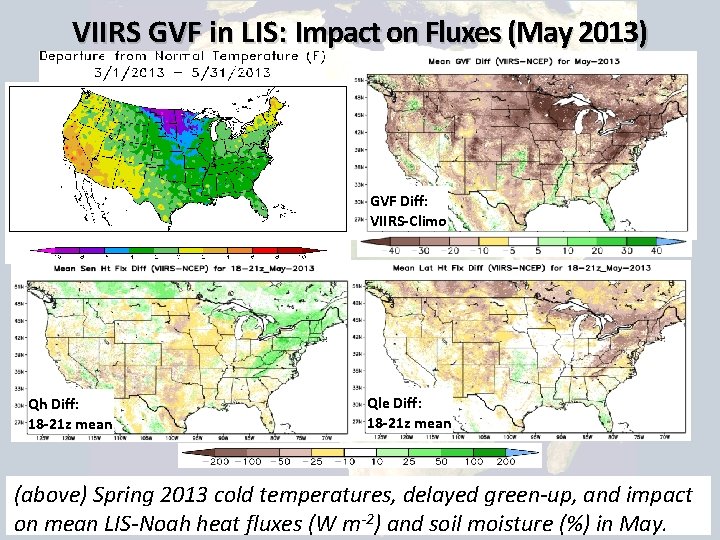
VIIRS GVF in LIS: Impact on Fluxes (May 2013) GVF Diff: VIIRS-Climo Qh Diff: 18 -21 z mean Qle Diff: 18 -21 z mean (above) Spring 2013 cold temperatures, delayed green-up, and impact on mean LIS-Noah heat fluxes (W m-2) and soil moisture (%) in May.

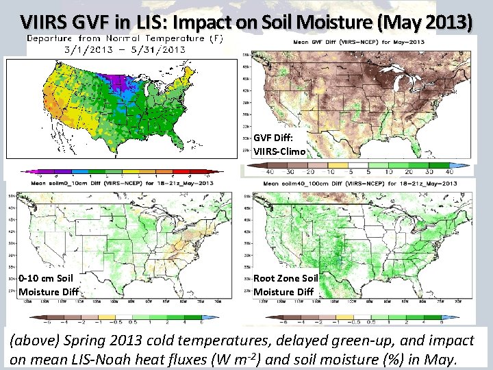
VIIRS GVF in LIS: Impact on Soil Moisture (May 2013) GVF Diff: VIIRS-Climo 0 -10 cm Soil Moisture Diff Root Zone Soil Moisture Diff (above) Spring 2013 cold temperatures, delayed green-up, and impact on mean LIS-Noah heat fluxes (W m-2) and soil moisture (%) in May.

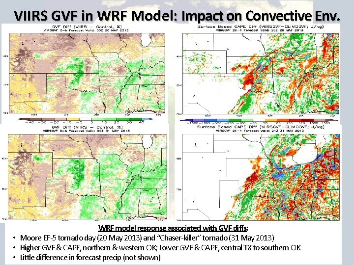
VIIRS GVF in WRF Model: Impact on Convective Env. WRF model response associated with GVF diffs: • Moore EF-5 tornado day (20 May 2013) and “Chaser-killer” tornado (31 May 2013) • Higher GVF & CAPE, northern & western OK; Lower GVF & CAPE, central TX to southern OK • Little difference in forecast precip (not shown)

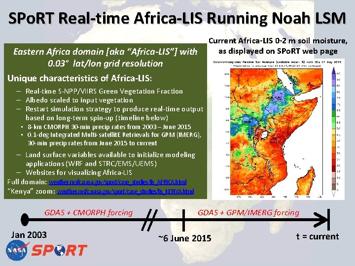
SPo. RT Real-time Africa-LIS Running Noah LSM Current Africa-LIS 0 -2 m soil moisture, as displayed on SPo. RT web page Eastern Africa domain [aka “Africa-LIS”] with 0. 03° lat/lon grid resolution Unique characteristics of Africa-LIS: – Real-time S-NPP/VIIRS Green Vegetation Fraction – Albedo scaled to input vegetation – Restart simulation strategy to produce real-time output based on long-term spin-up (timeline below) • 8 -km CMORPH 30 -min precip rates from 2003 – June 2015 • 0. 1 -deg Integrated Multi-satellit. E Retrievals for GPM (IMERG), 30 -min precip rates from June 2015 to current – Land surface variables available to initialize modeling applications (WRF and STRC/EMS/UEMS) – Websites for visualizing Africa-LIS Full domain: weather. msfc. nasa. gov/sport/case_studies/lis_AFRICA. html “Kenya” zoom: weather. msfc. nasa. gov/sport/case_studies/lis_KENYA. html GDAS + CMORPH forcing Jan 2003 GDAS + GPM/IMERG forcing ~6 June 2015 t = current

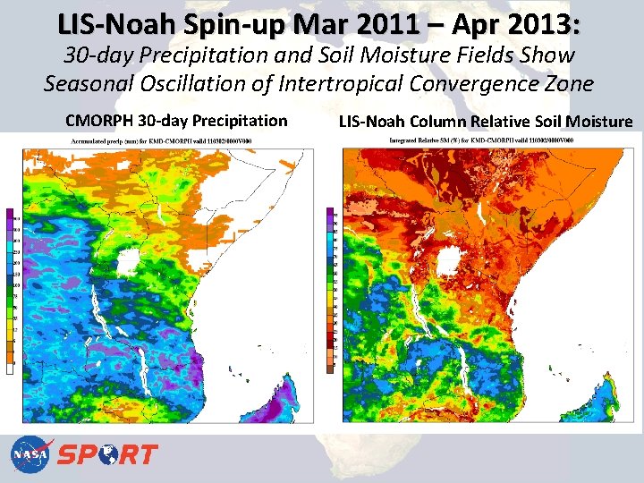
LIS-Noah Spin-up Mar 2011 – Apr 2013: 30 -day Precipitation and Soil Moisture Fields Show Seasonal Oscillation of Intertropical Convergence Zone CMORPH 30 -day Precipitation LIS-Noah Column Relative Soil Moisture

Soil Moisture Data Assimilation Assimilate satellite retrievals of soil moisture into a regional (3 -km) land surface model (e. g. , Africa-LIS). • Take advantage of high-resolution geophysical properties, best available atmospheric forcing, and latest satellite measurements of soil moisture Anticipated impacts • Improved representation of soil moisture fields • Better initialization of land surface for coupling with NWP models at convection-allowing resolution (~1 -4 km) for regional weather forecasting • Transition a real-time version of LIS output to end users

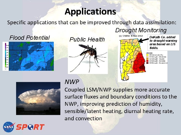
Applications Specific applications that can be improved through data assimilation: Drought Monitoring De. Kalb Co. added Flood Potential Public Health to drought warning area based on LIS fields. NWP Coupled LSM/NWP supplies more accurate surface fluxes and boundary conditions to the NWP, improving prediction of humidity, sensible/latent heating, diurnal heating rate, and convection
![SPo RT Work with SMAP and SMOS Lband radiometers and radars can Soil SPo. RT Work with SMAP [and SMOS] • L-band radiometers (and radars) can Soil](https://slidetodoc.com/presentation_image_h2/8a36573c1a1fe594246af232a2255bb1/image-18.jpg)
SPo. RT Work with SMAP [and SMOS] • L-band radiometers (and radars) can Soil Moisture and Ocean Salinity be used to estimate soil moisture near the surface SMOS – Compared to higher frequency instruments: o Sees deeper in the soil (~1 -5 cm) o Better vegetation penetration o Higher sensitivity (accuracy) o Larger footprint (~36 km) • Tested retrievals from Soil Moisture and Ocean Salinity (SMOS) satellite – Paper accepted in IEEE TGRS • Implementing assimilation of NASA Soil Moisture Active Passive (SMAP) retrievals – SMAP has higher resolution product but due to failure of radar, time period is limited to a few months. Name AMSR-E Soil Moisture Active/Passive SMAP SMOS SMAP Agency NASA/JAXA ESA NASA Launch 2002 2009 Jan. 2015 Orbit Polar Sensor Type Passive Active (Failed July 2015) Frequency 6. 9 GHz (C-band) 1. 4 GHz (L-band) 1. 41 GHz 1. 2 GHz Resolution 56 km 35 -50 km 36 km 3 km 9 km Accuracy 6 cm 3/cm 3 4 cm 3/cm 3 6 cm 3/c m 3 4 cm 3/cm 3 Combined (limited duration)

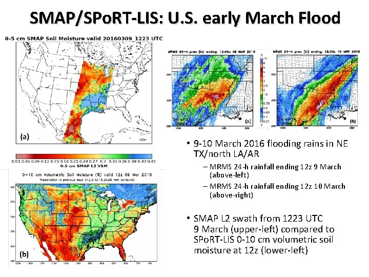
SMAP/SPo. RT-LIS: U. S. early March Flood SMOS • 9 -10 March 2016 flooding rains in NE TX/north LA/AR – MRMS 24 -h rainfall ending 12 z 9 March (above-left) – MRMS 24 -h rainfall ending 12 z 10 March (above-right) • SMAP L 2 swath from 1223 UTC 9 March (upper-left) compared to SPo. RT-LIS 0 -10 cm volumetric soil moisture at 12 z (lower-left)

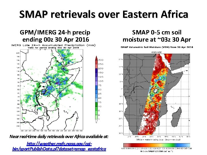
SMAP retrievals over Eastern Africa GPM/IMERG 24 -h precip ending 00 z 30 Apr 2016 Near real-time daily retrievals over Africa available at: http: //weather. msfc. nasa. gov/cgibin/sport. Publish. Data. pl? dataset=smap_eastafrica SMAP 0 -5 cm soil moisture at ~03 z 30 Apr

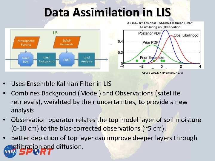
Data Assimilation in LIS Figure Credit: J. Anderson, NCAR. • Uses Ensemble Kalman Filter in LIS • Combines Background (Model) and Observations (satellite retrievals), weighted by their uncertainties, to provide a new analysis • Observation operator relates the top model layer of soil moisture (0 -10 cm) to the bias-corrected observations (~5 cm). • Better depiction of top layer can improve deeper layers through infiltration and diffusion.

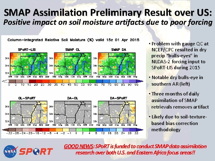
SMAP Assimilation Preliminary Result over US: Positive impact on soil moisture artifacts due to poor forcing • Problem with gauge QC at NCEP/CPC resulted in dry precip “bulls-eyes” in NLDAS-2 forcing input to SPo. RT-LIS during 2015 • Notable dry bulls-eye in southern AR (left) • Three months of daily assimilation of SMAP retrievals removes artifact • Likely due to soil-texturebased bias correction methodology GOOD NEWS: SPo. RT is funded to conduct SMAP data assimilation research over both U. S. and Eastern Africa focus areas!!

Questions and Discussion Any questions on LIS, GPM/IMERG, VIIRS GVF, or data assimilation with SMAP Soil Moisture?

So finally…. . Here are SPo. RT’s East Africa modeling experiment details using: UEMS, LIS, VIIRS GVF

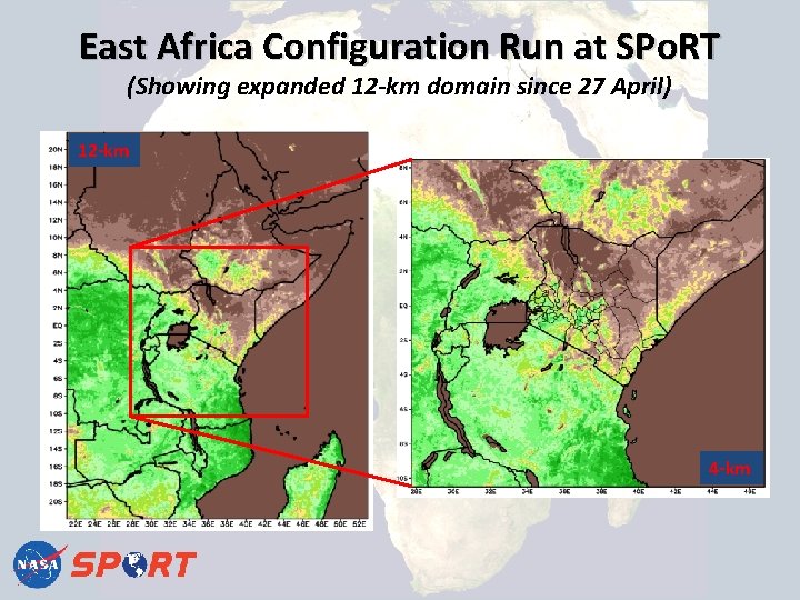
East Africa Configuration Run at SPo. RT (Showing expanded 12 -km domain since 27 April) 12 -km 4 -km

East-Africa configuration run at SPo. RT (Post-27 April 2016 WRF model configuration gruesome details) Grid setup: o Domain 1 (d 01): 297 [W-E] x 419 [S-N] o Domain 2 (d 02): 532 x 532 o 42 terrain-following vertical levels Model dynamics/physics: o o o o Advanced Research WRF (ARW), 3 rd-order Runge-Kutta time-integration 72 -second timestep for d 01 Multi-scale Kain-Fritsch convection (d 01 only; opt 11; CUDT=5 min) NASA/Goddard microphysics (opt 7; graupel+3 -ice) RRTM-Global short- and long-wave radiation (opt 4; RADT=10 min) Yonsei Univ. planetary boundary layer (opt 1; BLDT = 0) Noah land surface model (opt 2)

East-Africa configuration run at SPo. RT (Control vs. “LIS+VIIRS” simulations) Control: o Global Forecast System (GFS) model 0. 25 deg personal tile initial and boundary conditions (every 3 hours) o Hourly output to 48 hours on d 01 and d 02 o High-res MODIS green vegetation fraction (GVF) monthly climatology LIS+VIIRS experiment; identical domain and forecasts, except: o GFS land surface fields (soil moisture/temperature) replaced with SPo. RT -Land Information System (LIS) fields at ~3 -km resolution o MODIS GVF climatology replaced with real-time daily satellite GVF derived from the Visible Infrared Imaging Radiometer Suite (VIIRS) o 180 -hour forecasts on d 01 beginning 1 July 2016

East-Africa configuration run at SPo. RT (Web links for visualizing select fields) “Internal” WRF model web links for visualization o 12 -km d 01 domain: http: //weather. msfc. nasa. gov/sport/servir. Modeling. Africa/east. Africa/ o 4 -km nested d 02 domain: http: //weather. msfc. nasa. gov/sport/servir. Modeling. Africa/kenya/ Public Land Information System (Africa-LIS) pages: o Full East-Africa domain: http: //weather. msfc. nasa. gov/sport/case_studies/lis_AFRICA. html o Zoom over “Kenya”: http: //weather. msfc. nasa. gov/sport/case_studies/lis_KENYA. html SPo. RT planning to update modeling web interface (stay tuned!)

Open Discussion Q&A