Workshop on the Implementation of New NWP and

- Slides: 41

Workshop on the Implementation of New NWP and Impact-based Forecast and Warning Techniques (6 th-9 th September, 2016) Numerical Weather Prediction for the Services in India Meteorological Department Ananda Kumar Das

Organization ØIntroduction ØOperational NWP for different services ØEvolution of operational NWP ØMajor NWP Services ØRegional cooperation

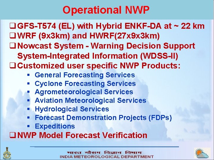
Operational NWP q GFS-T 574 (EL) with Hybrid ENKF-DA at ~ 22 km q WRF (9 x 3 km) and HWRF(27 x 9 x 3 km) q Nowcast System - Warning Decision Support System-Integrated Information (WDSS-II) q Customized user specific NWP Products: § § § § General Forecasting Services Cyclone Forecasting Services Agrometeorological Services Aviation Meteorological Services Hydrological Services Forecast Demonstration Projects (FDPs) Expeditions q NWP Model Forecast Verification

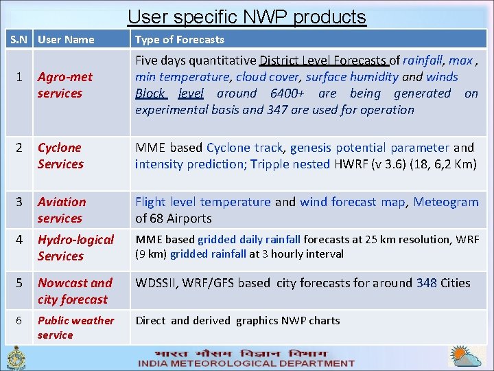
User specific NWP products S. N User Name Type of Forecasts 1 Agro-met services Five days quantitative District Level Forecasts of rainfall, max , min temperature, cloud cover, surface humidity and winds Block level around 6400+ are being generated on experimental basis and 347 are used for operation 2 Cyclone Services MME based Cyclone track, genesis potential parameter and intensity prediction; Tripple nested HWRF (v 3. 6) (18, 6, 2 Km) 3 Aviation services Flight level temperature and wind forecast map, Meteogram of 68 Airports 4 Hydro-logical Services MME based gridded daily rainfall forecasts at 25 km resolution, WRF (9 km) gridded rainfall at 3 hourly interval 5 Nowcast and city forecast WDSSII, WRF/GFS based city forecasts for around 348 Cities 6 Public weather service Direct and derived graphics NWP charts

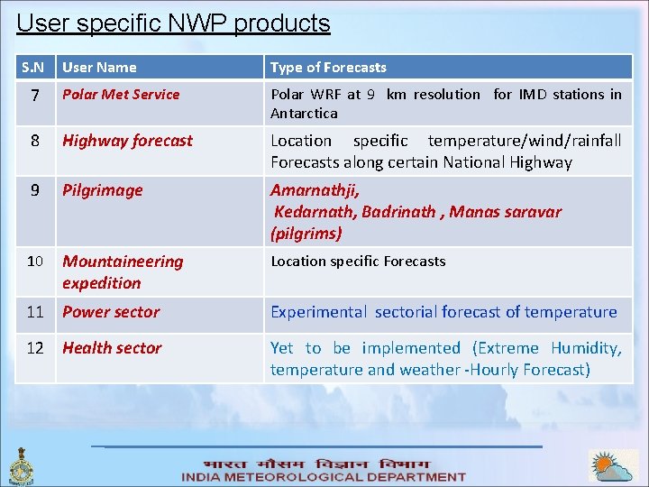
User specific NWP products S. N User Name Type of Forecasts 7 Polar Met Service Polar WRF at 9 km resolution for IMD stations in Antarctica 8 Highway forecast Location specific temperature/wind/rainfall Forecasts along certain National Highway 9 Pilgrimage Amarnathji, Kedarnath, Badrinath , Manas saravar (pilgrims) 10 Mountaineering expedition Location specific Forecasts 11 Power sector Experimental sectorial forecast of temperature 12 Health sector Yet to be implemented (Extreme Humidity, temperature and weather -Hourly Forecast)

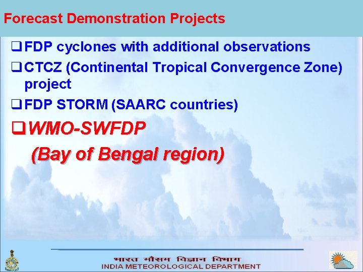
Forecast Demonstration Projects q FDP cyclones with additional observations q CTCZ (Continental Tropical Convergence Zone) project q FDP STORM (SAARC countries) q. WMO-SWFDP (Bay of Bengal region)

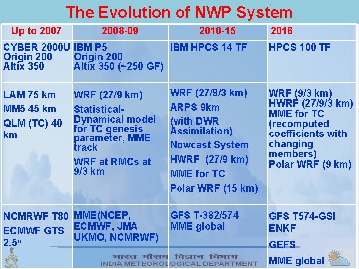
The Evolution of NWP System Up to 2007 2008 -09 2010 -15 CYBER 2000 U IBM P 5 IBM HPCS 14 TF Origin 200 Altix 350 (~250 GF) LAM 75 km MM 5 45 km QLM (TC) 40 km WRF (27/9 km) Statistical. Dynamical model for TC genesis parameter, MME track WRF at RMCs at 9/3 km NCMRWF T 80 MME(NCEP, ECMWF GTS ECMWF, JMA UKMO, NCMRWF) 2. 5 o 2016 HPCS 100 TF WRF (27/9/3 km) ARPS 9 km (with DWR Assimilation) Nowcast System HWRF (27/9 km) MME for TC Polar WRF (15 km) WRF (9/3 km) HWRF (27/9/3 km) MME for TC (recomputed coefficients with changing members) Polar WRF (9 km) GFS T-382/574 MME global GFS T 574 -GSI ENKF GEFS MME global

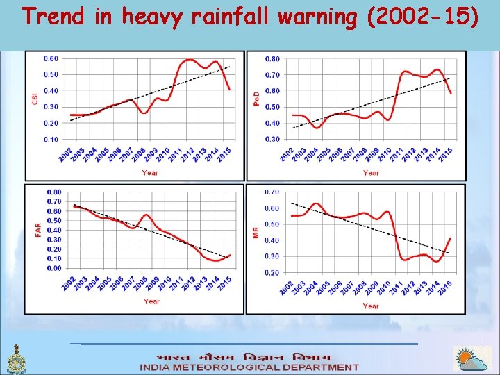
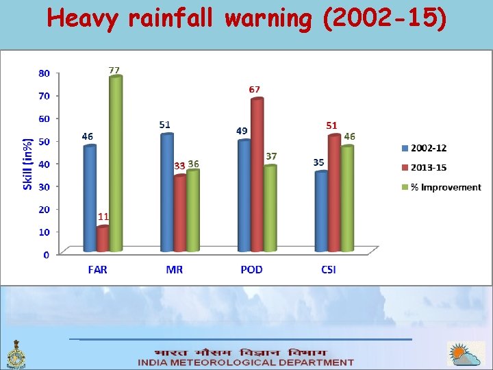
Trend in heavy rainfall warning (2002 -15)

Heavy rainfall warning (2002 -15)

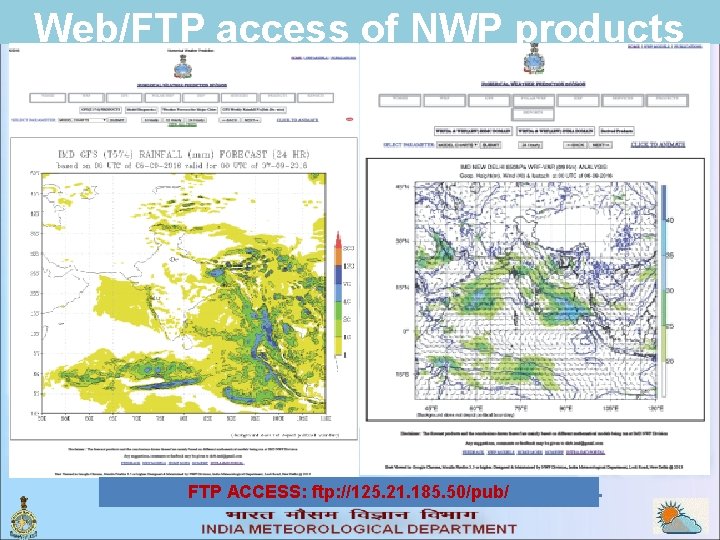
Web/FTP access of NWP products FTP ACCESS: ftp: //125. 21. 185. 50/pub/

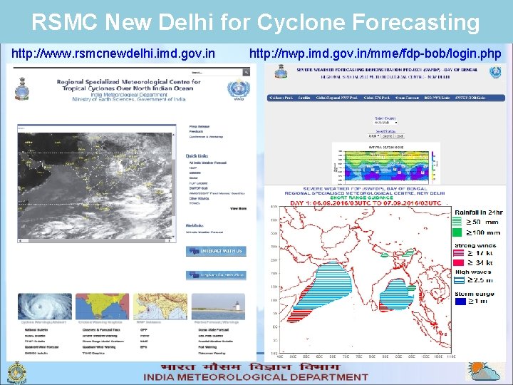
RSMC New Delhi for Cyclone Forecasting http: //www. rsmcnewdelhi. imd. gov. in http: //nwp. imd. gov. in/mme/fdp-bob/login. php

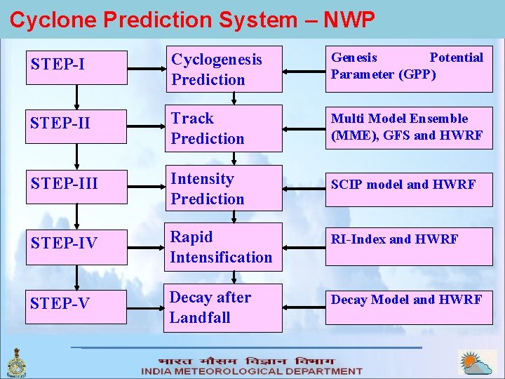
Cyclone Prediction System – NWP STEP-I Cyclogenesis Prediction Genesis Potential Parameter (GPP) STEP-II Track Prediction Multi Model Ensemble (MME), GFS and HWRF STEP-III Intensity Prediction SCIP model and HWRF STEP-IV Rapid Intensification RI-Index and HWRF STEP-V Decay after Landfall Decay Model and HWRF

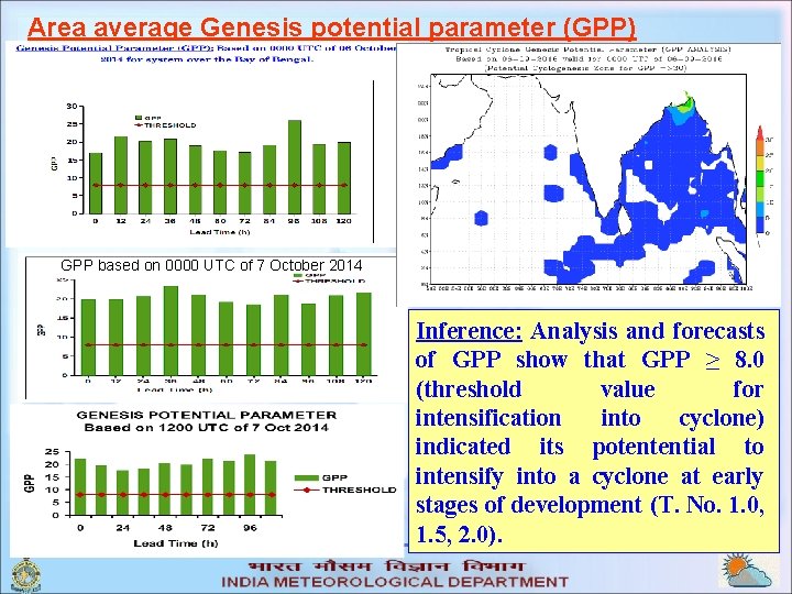
Area average Genesis potential parameter (GPP) GPP based on 0000 UTC of 7 October 2014 Inference: Analysis and forecasts of GPP show that GPP ≥ 8. 0 (threshold value for intensification into cyclone) indicated its potentential to intensify into a cyclone at early stages of development (T. No. 1. 0, 1. 5, 2. 0).

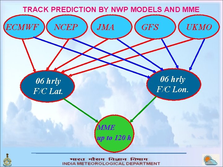
TRACK PREDICTION BY NWP MODELS AND MME ECMWF NCEP JMA GFS UKMO 06 hrly F/C Lon. 06 hrly F/C Lat. MME up to 120 h

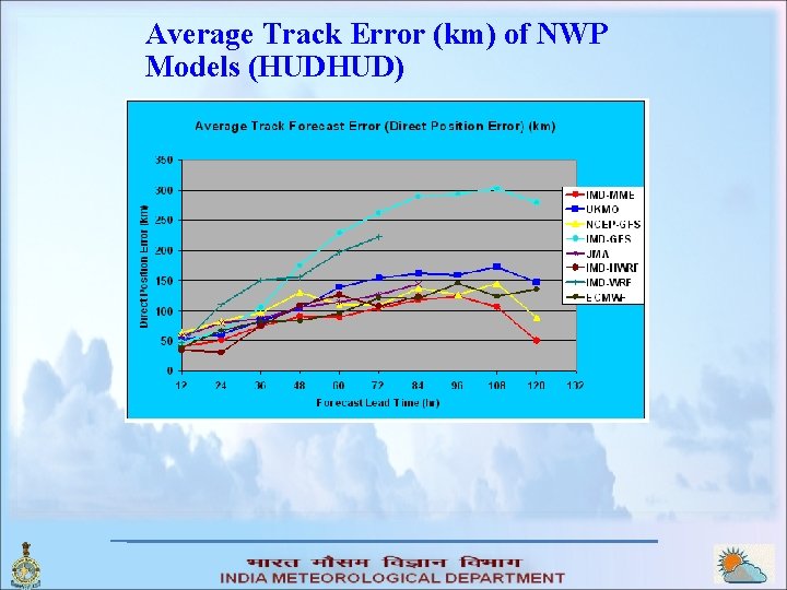
Average Track Error (km) of NWP Models (HUDHUD)

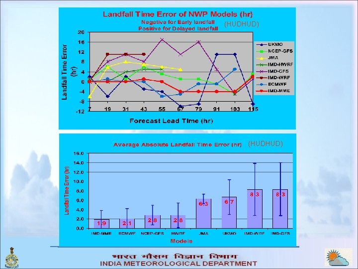
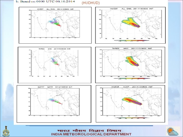
(HUDHUD)

(HUDHUD)

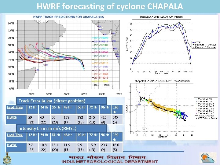
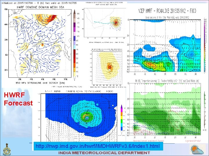
HWRF forecasting of cyclone CHAPALA Track Error in km (direct position) Lead Time 12 Hr 24 Hr 36 Hr 48 Hr HWRF 39 (22) 63 (22) 55 (20) 128 (17) 60 Hr 72 Hr 96 Hr 120 Hr 182 245 416 549 (15) (13) (9) (5) Intensity Error in m/s (RMSE) Lead Time 12 Hr 24 Hr 36 Hr 48 Hr HWRF 7. 7 (22) 10. 3 (22) 13. 1 (20) 11. 9 (17) 60 Hr 72 Hr 96 Hr 120 Hr 9. 9 15. 9 20. 7 16. 6 (15) (13) (9) (5)

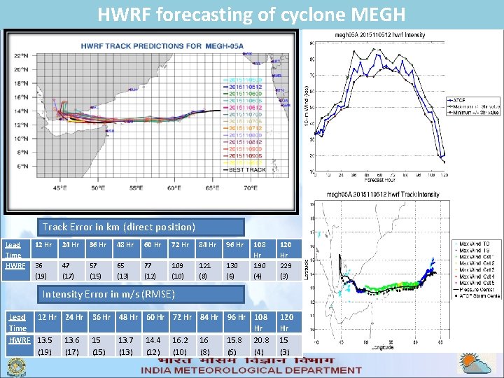
HWRF forecasting of cyclone MEGH Track Error in km (direct position) Lead Time HWRF 12 Hr 24 Hr 36 Hr 48 Hr 60 Hr 72 Hr 84 Hr 96 Hr 36 (19) 47 (17) 57 (15) 65 (13) 77 (12) 109 (10) 121 (8) 130 (6) 108 Hr 190 (4) 120 Hr 229 (3) Intensity Error in m/s (RMSE) Lead 12 Hr 24 Hr 36 Hr 48 Hr 60 Hr 72 Hr 84 Hr Time HWRF 13. 5 13. 6 15 13. 7 14. 4 16. 2 16 (19) (17) (15) (13) (12) (10) (8) 96 Hr 108 Hr 15. 8 20. 8 (6) (4) 120 Hr 15 (3)

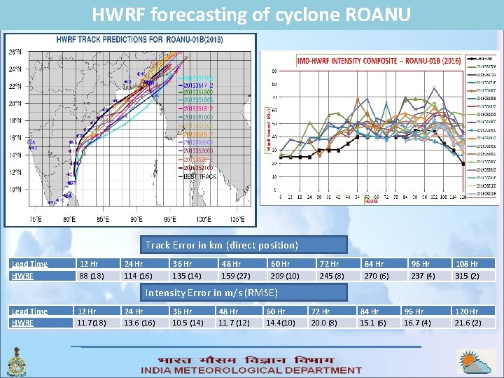
HWRF forecasting of cyclone ROANU Track Error in km (direct position) Lead Time HWRF 12 Hr 88 (18) 24 Hr 114 (16) 36 Hr 135 (14) 48 Hr 159 (27) 60 Hr 209 (10) 72 Hr 245 (8) 84 Hr 270 (6) 96 Hr 237 (4) 108 Hr 315 (2) Intensity Error in m/s (RMSE) Lead Time HWRF 12 Hr 11. 7(18) 24 Hr 13. 6 (16) 36 Hr 10. 5 (14) 48 Hr 11. 7 (12) 60 Hr 14. 4(10) 72 Hr 20. 0 (8) 84 Hr 15. 1 (6) 96 Hr 16. 7 (4) 120 Hr 21. 6 (2)

HWRF Forecast http: //nwp. imd. gov. in/hwrf/IMDHWRFv 3. 6/index 1. html

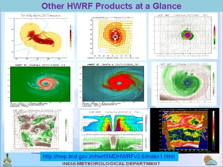
Other HWRF Products at a Glance http: //nwp. imd. gov. in/hwrf/IMDHWRFv 3. 6/index 1. html

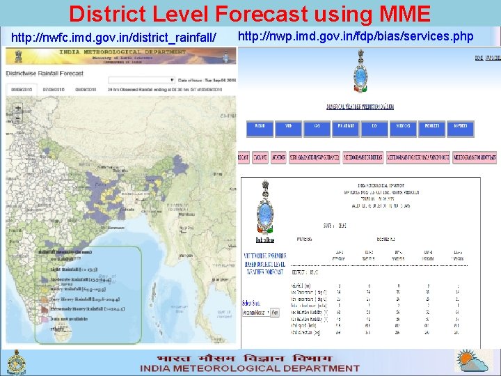
District Level Forecast using MME http: //nwfc. imd. gov. in/district_rainfall/ http: //nwp. imd. gov. in/fdp/bias/services. php

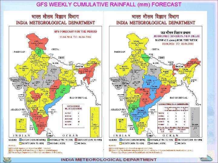
GFS WEEKLY CUMULATIVE RAINFALL (mm) FORECAST

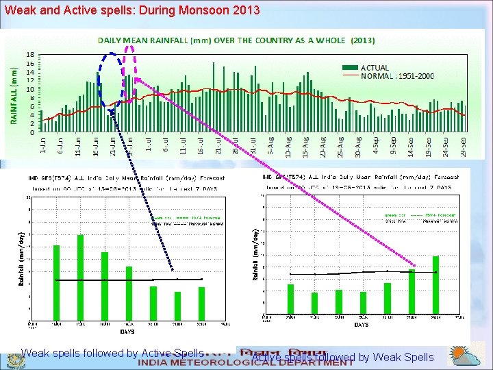
Weak and Active spells: During Monsoon 2013 Weak spells followed by Active Spells Active spells followed by Weak Spells

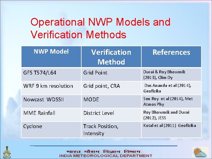
Operational NWP Models and Verification Methods NWP Model Verification Method References GFS T 574/L 64 Grid Point Durai & Roy Bhowmik (2013), Clim Dy WRF 9 km resolution Grid point, CRA Das Ananda et al (2014), Geofizika Nowcast WDSSII MODE Sen Roy et al (2014), Met Atmos Phy MME Rainfall District Level Roy Bhowmik and Durai (2012), JESS Cyclone Track Position, Intensity Kotal et al (2011) Geofizika

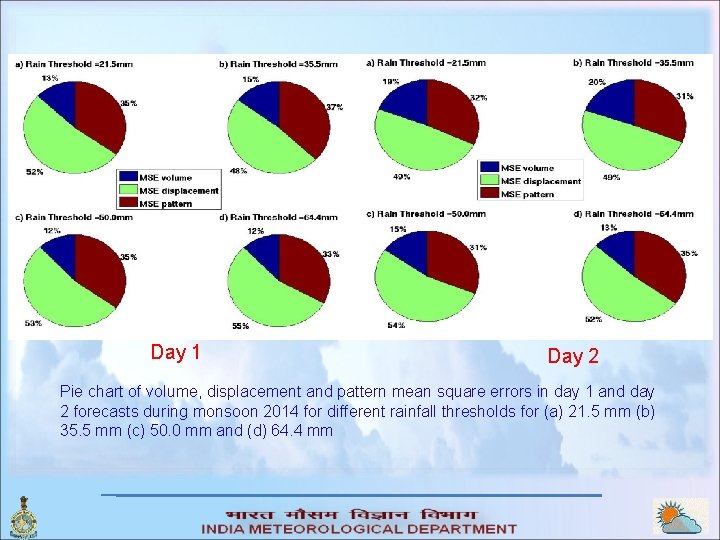
Day 1 Day 2 Pie chart of volume, displacement and pattern mean square errors in day 1 and day 2 forecasts during monsoon 2014 for different rainfall thresholds for (a) 21. 5 mm (b) 35. 5 mm (c) 50. 0 mm and (d) 64. 4 mm

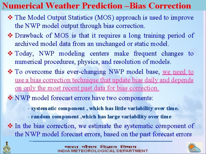
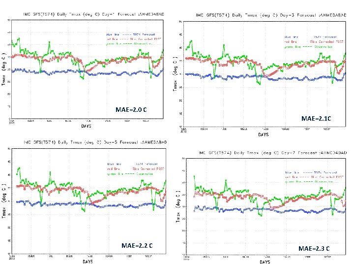
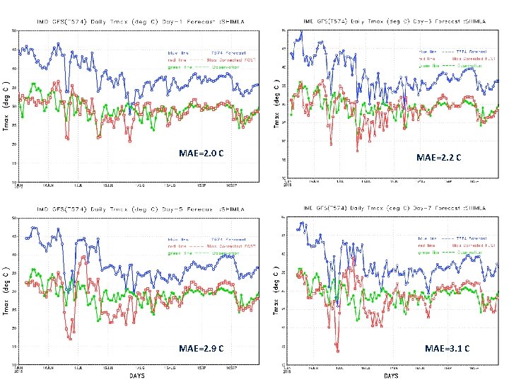
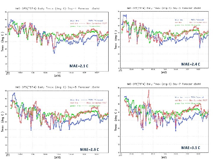
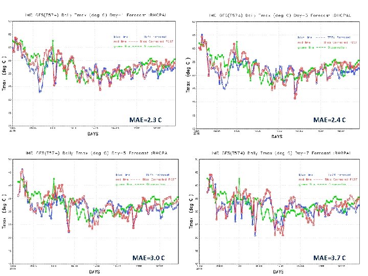
Numerical Weather Prediction –Bias Correction v The Model Output Statistics (MOS) approach is used to improve the NWP model output through bias correction. v Drawback of MOS is that it requires a long training period of archived model data from an unchanged or static model. v Today, NWP modeling centers make frequent changes to numerical procedures, physics, and resolution of models. v To overcome this ever-changing NWP model base, we need to use a bias correction technique that update bias daily and depends on only the most recent past data for bias correction. v NWP model forecast errors have two components: - systematic component , which has little variability over time. - random component , which has large variability over time v In the bias correction, we estimate the systematic component of the NWP model forecast errors, based on the past forecast errors

MAE=2. 0 C MAE=2. 1 C MAE=2. 2 C MAE=2. 3 C

MAE=2. 0 C MAE=2. 9 C MAE=2. 2 C MAE=3. 1 C

MAE=2. 1 C MAE=2. 6 C MAE=2. 4 C MAE=3. 1 C

MAE=2. 3 C MAE=3. 0 C MAE=2. 4 C MAE=3. 7 C

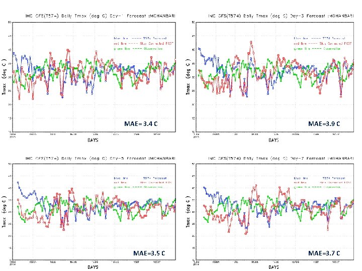
MAE= 3. 4 C MAE=3. 5 C MAE=3. 9 C MAE=3. 7 C

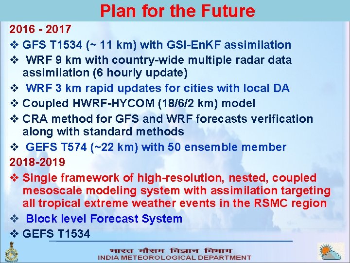
Plan for the Future 2016 - 2017 v GFS T 1534 (~ 11 km) with GSI-En. KF assimilation v WRF 9 km with country-wide multiple radar data assimilation (6 hourly update) v WRF 3 km rapid updates for cities with local DA v Coupled HWRF-HYCOM (18/6/2 km) model v CRA method for GFS and WRF forecasts verification along with standard methods v GEFS T 574 (~22 km) with 50 ensemble member 2018 -2019 v Single framework of high-resolution, nested, coupled mesoscale modeling system with assimilation targeting all tropical extreme weather events in the RSMC region v Block level Forecast System v GEFS T 1534

Collaborators with IMD v EMC-NCEP and HRD – Mo. U between NOAA, USA and Mo. ES, India § Monsoon Mission program of Mo. ES § Tropical Cyclone Project v NCAR, USA – Mo. U between UCAR and Mo. ES, India v KMA – Mo. U between KMA and Mo. ES v The Agency for Meteorology Climatology and Geophysics, Indonesia – Mo. U with Mo. ES v National Partners: Mo. ES Institutes – NCMRWF, INCOIS and IITM

Regional cooperation Ø Activities of RSMC, New Delhi Ø Umbrella of WMO-SWFDP - Strengthening the capacity in National Meteorological and Hydrological Services (NMHSs) Ø Supporting the programs of RIMES Ø Active technology exchange/development program Ø Sharing of service oriented weather applications

THANK YOU

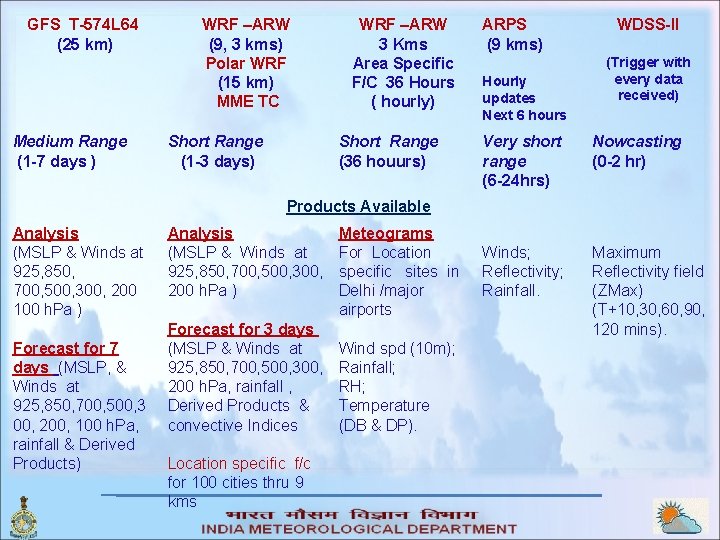
GFS T-574 L 64 (25 km) Medium Range (1 -7 days ) WRF –ARW (9, 3 kms) Polar WRF (15 km) MME TC Short Range (1 -3 days) WRF –ARW 3 Kms Area Specific F/C 36 Hours ( hourly) Short Range (36 houurs) ARPS (9 kms) Hourly updates Next 6 hours WDSS-II (Trigger with every data received) Very short range (6 -24 hrs) Nowcasting (0 -2 hr) Winds; Reflectivity; Rainfall. Maximum Reflectivity field (ZMax) (T+10, 30, 60, 90, 120 mins). Products Available Analysis (MSLP & Winds at 925, 850, 700, 500, 300, 200 100 h. Pa ) Forecast for 7 days (MSLP, & Winds at 925, 850, 700, 500, 3 00, 200, 100 h. Pa, rainfall & Derived Products) Analysis (MSLP & Winds at 925, 850, 700, 500, 300, 200 h. Pa ) Forecast for 3 days (MSLP & Winds at 925, 850, 700, 500, 300, 200 h. Pa, rainfall , Derived Products & convective Indices Location specific f/c for 100 cities thru 9 kms Meteograms For Location specific sites in Delhi /major airports Wind spd (10 m); Rainfall; RH; Temperature (DB & DP).

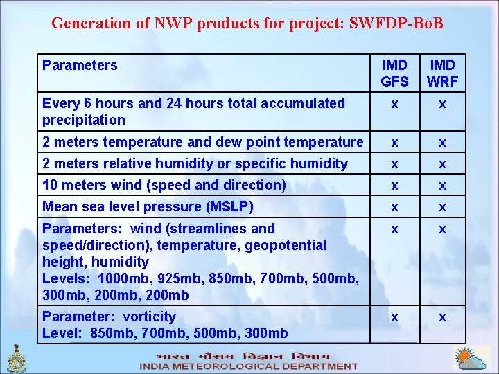
Generation of NWP products for project: SWFDP-Bo. B Parameters IMD GFS IMD WRF Every 6 hours and 24 hours total accumulated precipitation x x 2 meters temperature and dew point temperature x x 2 meters relative humidity or specific humidity x x 10 meters wind (speed and direction) x x Mean sea level pressure (MSLP) x x Parameters: wind (streamlines and speed/direction), temperature, geopotential height, humidity Levels: 1000 mb, 925 mb, 850 mb, 700 mb, 500 mb, 300 mb, 200 mb x x Parameter: vorticity Level: 850 mb, 700 mb, 500 mb, 300 mb x x

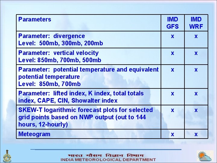
Parameters IMD GFS IMD WRF Parameter: divergence Level: 500 mb, 300 mb, 200 mb x x Parameter: vertical velocity Level: 850 mb, 700 mb, 500 mb x x Parameter: potential temperature and equivalent potential temperature Level: 850 mb, 700 mb x x Parameter: lifted index, K index, totals index, CAPE, CIN, Showalter index x x SKEW-T logarithmic forecast plots for selected grid points based on NWP output (out to 144 hours, 12 -hourly) x x Meteogram x x

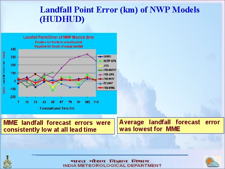
Landfall Point Error (km) of NWP Models (HUDHUD) MME landfall forecast errors were consistently low at all lead time Average landfall forecast error was lowest for MME