PREDICTING WEATHER INSTRUCTOR MS SORN USING YOUR DO

 • QUESTION: How does latitude and")
 • Geographic coordinate")


 INSTRUCTOR: MS. SORN")
 • QUESTION: How might meteorologists use")

: Study of specific")


")


- Slides: 28
PREDICTING WEATHER INSTRUCTOR: MS. SORN
USING YOUR “DO NOW” SHEET – MONDAY (2/13/17) • QUESTION: How does latitude and air circulation affect climate? • RECALL: Latitude is the distance of a location from the equator. The rotational speed of the earth changes based on latitude. ANSWER: Latitude affects the amount of sunlight a given area receives. The rotation of the earth keeps the wind from blowing straight. Its path becomes curved and it is deflected. This force is called the Coriolis Effect.
KEY VOCAB 05 – WORDS 1, 2 • 1. latitude (noun) • Geographic coordinate that specifies the northsouth position of a point on the Earth’s surface. • 2. altitude (noun) • Distance from sea level.
READING SCIENCE: THE CORIOLIS EFFECT • TRADE PAPERS & CORRECT out of 6 points
LEARNING TARGET • I will able to explain how latitude, terrain, and altitude all play a role in the climate of a given location.
PG# PREDICTING WEATHER 2/13/17 • ESSENTIAL QUESTIONS • BIG IDEAS • 1. What is the difference in the path of deflection between hemispheres? • 1. In the northern hemisphere, wind is deflected to the right. In the southern hemisphere, wind is deflected to the left. It is a result of the earth’s rotation under the force of the Coriolis Effect.
PG# PREDICTING WEATHER 2/13/17 • ESSENTIAL QUESTIONS • BIG IDEAS • 2. Describe the flow of air from the equator to the poles. (Involve the hemispheres). • 2. Each hemisphere has three bands of circulating air masses. Each represents 30 degrees latitude. At the equator, warm humid air rises causing low pressure and flows towards the poles.
PG# PREDICTING WEATHER 2/13/17 • ESSENTIAL QUESTIONS • 3. What are trade winds? • BIG IDEAS • 3. Blowing at a steady speed, the winds that flow from east to west close to the equator are known as trade winds.
PREDICTING WEATHER (DAY 2) INSTRUCTOR: MS. SORN
USING YOUR “DO NOW” SHEET – TUESDAY (2/14/17) • QUESTION: How might meteorologists use probability? • RECALL: The definition of probability… The role of meteorologists… • The likelihood or chance of something happening (probability). A meteorologist studies weather. ANSWER: Collections of data are plugged into algorithms (a formula for solving a problem) to help predict weather conditions.
HOMEWORK- 2/14 • READING SET – “PREDICTING WEATHER- DO THE TRY NOW
KEY VOCAB 05 – WORDS 3, 4 3. Regional geography (adj/noun): Study of specific regions of the Earth 4. Atmospheric Circulation (adj/noun): The large scale movement of air around the Earth
LEARNING TARGET • I will plan a scientific investigation of the various factors that affect global ocean surface currents.
DUE NOW: MATH CONNECTIONS & CER • COLLECTING: MATH CONNECTIONS • GRADING: CER (TRADE AND SCORE OUT OF 20 POINTS)
HOW TO GRADE THE CER • OUT OF 20 POINTS • 5 POINTS- (CLAIM) 1 SENTENCE RESPONDS TO PROMPT • 5 POINTS- (EVIDENCE) 2+ SENTENCES ANALYZING THE DATA • 5 POINTS- (REASONING) 3+ SENTENCES • 5 POINTS- (NAME, DATE, PERIOD) & SEPARATE LABELS OF CLAIM, EVIDENCE, REASONING
5 POINTS- 1 SENTENCE RESPONDING TO PROMPT • Sample Claim: I disagree with Jennifer's claim and believe that points A and B would have different climates due to other influences at work.
5 POINTS – ANALYZES DATA • Sample Evidence: Point A is near the coast and Point B is further inland. Point A is on the windward side of the mountains and Point B is on the leeward side. Both are on the same line of latitude and have winds moving from west to east.
• Sample Reasoning: The climates of Points A and B are different even though both Points are at the same latitude of about 40 o N and have winds blowing from the west to the east. Point A is near the coast and on the windward side of a mountain chain. Both of these factors would cause it to be cooler with moderate temperatures (small variation between high and low temperatures) and have more precipitation than Point B. Moisture from the ocean evaporates into the surrounding air. The wind blows the moisture-filled air from the ocean toward the land. The mountain range acts as a block, directing the moist air upward into the atmosphere, where the air quickly cools. The moisture condenses out of the cooled air, forming clouds and precipitation. Since the airflow is directed upward by the mountains and not eastward, all of the precipitation falls on the side of the mountain closest to the ocean. The cooled moisture-free air flows beyond the mountain toward Point B is on the leeward side of the mountain; as a result, Point B has a much drier climate than Point A. Point B is inland, which will result in Point B having higher high
LAB : CURRENTS & CLIMATES STUDENTS WILL COMPARE THE AVERAGE CLIMATE DATA OF TWO LANDMASSES TO DETERMINE THE EFFECT OF OCEAN CURRENTS ON CLIMATE.
PRE-INVESTIGATION DISCUSSION 1. 2. 3. 4. What forms the global ocean surface currents? Are all currents the same temperature? Why not? Does the temperature of a current affect the climate of a landmass? 5. How could we test your ideas?
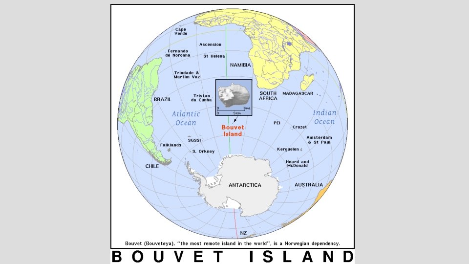
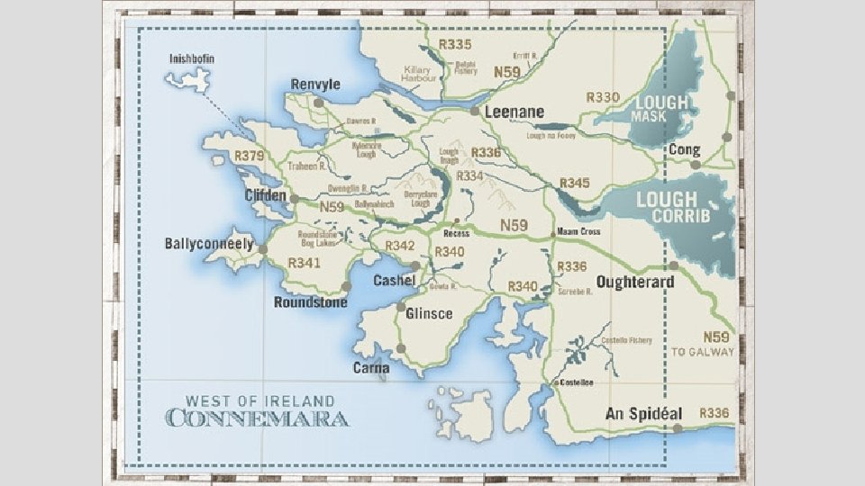
POST-INVESTIGATION DISCUSSION 1. When plotted on the world map, what current flows near Bouvet Island? 2. When plotted on the world map, what current flows near Clifden, Ireland? 3. How did these currents affect the average temperatures?
LAB: CURRE NT S & CLI MATES • Step 1: How does an ocean current affect the climate of a landmass? Step 2: The climate affects the people who live in the area. Some climates are influenced by the ocean currents and not just the longitude and latitude of a location. Step 3: There will be no independent or dependent variables in this investigation therefore there is not a control group. Step 4: If the ocean current passing by a landmass is warm, then the climate will be warm and humid with enough rainfall for plant life.
LAB: CURRE NT S & CLI MATES • STEP 5 REFERENCE SHEET
S TE P 8 - Average High and Low Temperatures Jan Feb Mar Apr May June July Aug Sept Oct Nov Dec Bouve 3 t Island 0 4 3 2 1 0 -1 -1 -1 0 1 3 0 0 0 -2 -4 -5 -5 -5 -3 -2 -1 9 9 11 13 16 18 20 20 18 14 11 9 3 3 4 4 7 10 12 11 9 7 4 3 Clifdo n, Irelan d
S TE P 9 – S AM PLE G RAPH
ST EP 10 - The landmass with the cold water current has lower average temperatures than the landmass with the warm water current.