Gravity Monitoring Activities at NGS and an introduction


 •")


 will be redefining")

 will be replaced by North American Terrestrial")
 Pacific")
 will be replaced by the North")

")
 • accurate")

 + Intermediate")

.")


- Slides: 25
Gravity Monitoring Activities at NGS and an introduction to the New Geodetic Datums -- A Whirlwind tour Presented by Daniel Winester, Geodesist, NGS Gravimetry Representative to the Geophysics Committee of U. S. National Section of PAIGH since 2002
In the past few decades NGS’ gravity work has concentrated on Temporal gravity change & Gravity maps (spatial variation)
Gravity or g refers to the acceleration of gravity near the Earth’s surface: g 9. 8 meters/second². We measure to g = 9. 80 654 321 m/sec² 1 Gal = 1 cm/sec² So we measure to micro. Gals.
Things which can cause gravity change: • Elevation change; such as glacial isostatic adjustment (GIA), ground compaction, tectonic movement, ground water effect, etc. +3 µGal ≈ -1 cm in height change • Nearby mass changes; such as mantle reaction to GIA, water-table, soil moisture or snowpack change, magma or lava movement, tectonic movements, anthropogenic changes, etc. +1 µGal ≈ +2. 5 cm in water-table rise
For this we have used absolute gravimeters: • JILAg-4 (accuracy ± 5 µGals) • FG 5 -102 & -111 (accuracy ± 2 µGals) (accuracy at top of drop) • And various L&R land gravimeters with feedback systems for gradients
Absolute gravity contributions from NOAA-NGS, Canadian Geodetic Survey & Geological Survey of Canada
Light blue: observed AG Green: suggested sites Blue squares: observed by Canadians
At a recent PAIGH meeting, I mentioned that NGS (with others) will be redefining the geodetic datums. Since there was interest, I thought I’d cover some of that.
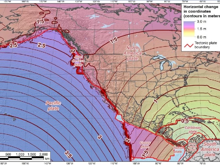
And now, some alphabet soup: The current horizontal geodetic datum • NAD 83 = North American Datum of 1983. The current vertical geodetic datum • NAVD 88 = North American Vertical Datum of 1988. These had replaced NAD 27 and NDVG 29. In 2022, NGS looks to replace them. • Newer & better integrated data (think GNSS data). • Better models. • Tectonic plates have moved.
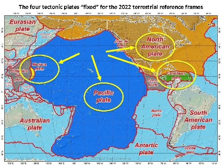
North American Datum of 1983 (NAD 83) will be replaced by North American Terrestrial Reference Frame of 2022 (NATRF 2022) Note that ‘Reference Frame’ is preferred over ‘Datum’
Four “Plate-Fixed” Reference Frames North American Terrestrial Reference Frame of 2022 (NATRF 2022) Pacific Terrestrial Reference Frame of 2022 (PATRF 2022) Caribbean Terrestrial Reference Frame of 2022 (CATRF 2022) Mariana Terrestrial Reference Frame of 2022 (MATRF 2022) These reference frames will fix issues of past movements and a better definition of the Earth’s center of mass. Reference frames will be dynamic. Will be used in Canada and Mexico.
North American Vertical Datum of 1988 (NAVD 88) will be replaced by the North American-Pacific Geopotential Datum of 2022 (NAPGD 2022)
Why Replace NAVD 88?
Why Replace NAVD 88? • tilt in the "zero surface” (intended to be flat) • had been accessed by BMs in the ground, but many have been disturbed. Approximate Error in NAVD 88 "zero surface” wrt satellite-derived data
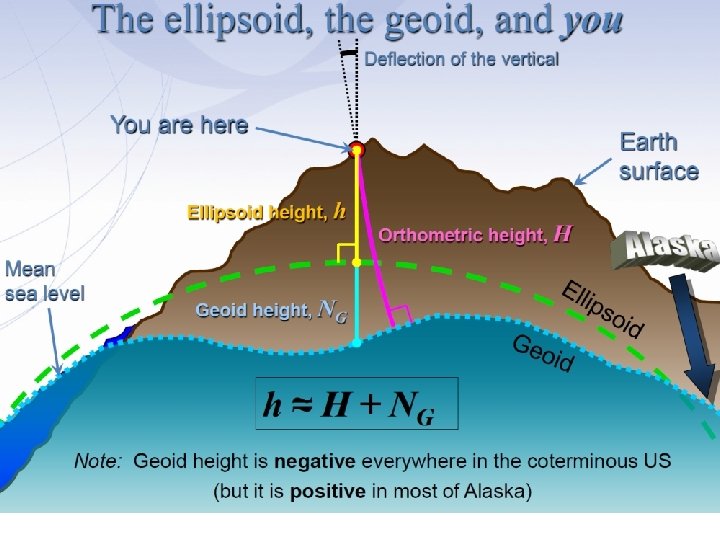
Replacing NAVD 88 • primary access via GNSS and geoid (think OPUS) • accurate continental gravimetric geoid (1 -2 cm) The Geoid is the Equipotential Surface that corresponds to Global Mean Sea Level. Orthometric Elevations are Defined as Height above Geoid. • aligned with: 1) NATRF 2022 (or CATRF, PATRF, MATRF) 2) global mean sea level (GMSL) • monitor time-varying nature of gravity (NGS Geoid Monitoring Service Ge. MS)
Calculating Ng is not easy! • First you need a gravity field – data collected from different distances away from Earth • Next calculate gravity anomaly, or ∆g • Then, just solve Stokes’ integral! • R is the mean radius of the earth • ɣ 0 is mean surface gravity on ellipsoid • S is a geometric function of position …there’s a catch • Need to know ∆g over entire surface of the earth
Building a Gravity Field Model GRACE/GOCE/Satellite Altimetry Long Wavelengths (> 250 km) + Intermediate Wavelengths (20 km to 300 km) Airborne Observations + Short Wavelengths (< 100 km) Terrestrial/Surface Observations and Predicted Gravity from Topography
GRAV-D – airborne relative gravimeters a h t re 1% 8 n n w lo f Mo For the intermediate wavelength component, fly the country & territories & near shore at spacing of 10 km with airborne relative gravimeters.
Terrestrial Gravimeters - Absolute and Relative Constrain data with an absolute gravimeter (A 10025). Make ties to aircraft with a relative gravimeter (CG 6)
Sea Level Change and the Geoid Threshold is about 20 cm or about 60 years.
Obviously, this was a way-too brief explanation of the new reference frames. For more details see the Blueprint(s) for 2022 Part 1: Geometric Coordinates NOAA Technical Report NOS NGS 62 Part 2: Geopotential Coordinates NOAA Technical Report NOS NGS 64 Part 3: Working in the Modernized NSRS NOAA Technical Report NOS NGS 67 Geodesy. noaa. gov/library/NOAA Technical Reports
Thank you for your attention Daniel Winester NOAA – NGS – Skaggs 2 C 604 325 South Broadway Boulder, CO 80305 303 -497 -6132 Daniel. Winester@noaa. gov Geodesy. noaa. gov I acknowledge that NGS’ Jeff Jalbrzilkoski & the NGS presentation library were responsible for the content of many slides presented.