Chapter 1 What is the Mesoscale Mesoscale energy
- Slides: 15

Chapter 1: What is the Mesoscale? Mesoscale energy sources

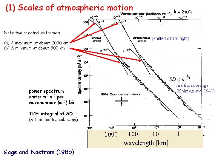
(1) Scales of atmospheric motion k = 2 p/l Note two spectral extremes: [shifted x 10 to right] (a) A maximum at about 2000 km (b) A minimum at about 500 km inertial subrange (Kolmogorov 1941) power spectrum units: m 2 s-2 per wavenumber (m-1) bin TKE: integral of SD (within inertial subrange) 1000 Gage and Nastrom (1985) 100 10 wavelength [km] 1

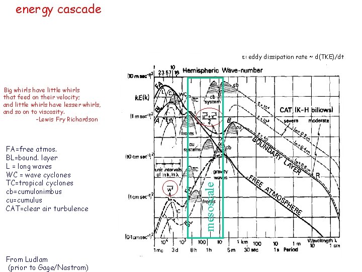
energy cascade e: eddy dissipation rate ~ d(TKE)/dt FA=free atmos. BL=bound. layer L = long waves WC = wave cyclones TC=tropical cyclones cb=cumulonimbus cu=cumulus CAT=clear air turbulence From Ludlam (prior to Gage/Nastrom) mesoscale Big whirls have little whirls that feed on their velocity; and little whirls have lesser whirls, and so on to viscosity. -Lewis Fry Richardson

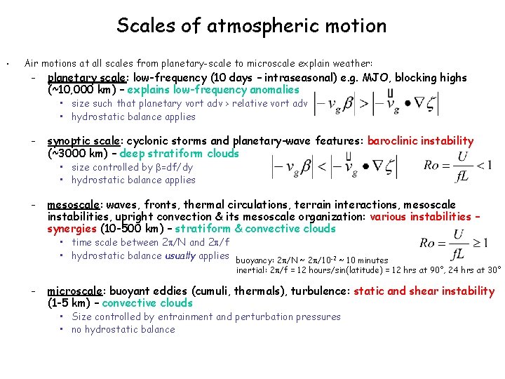
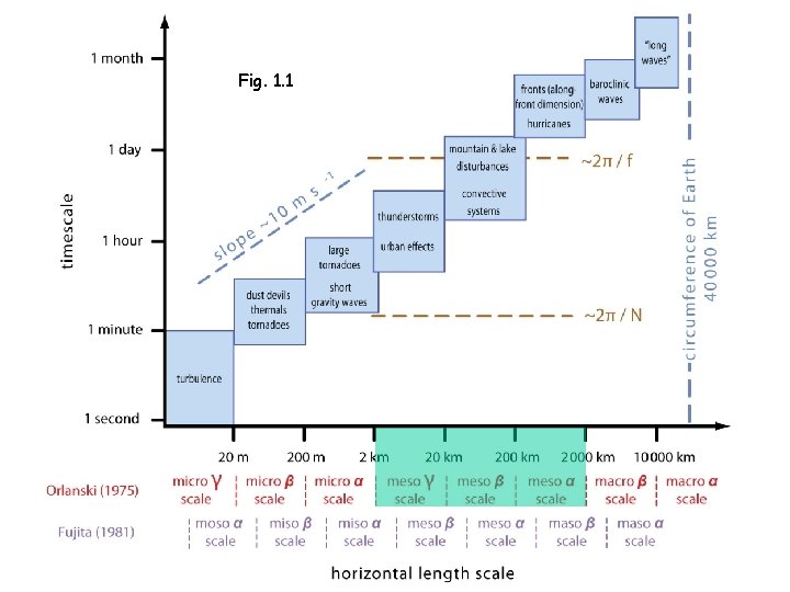
Scales of atmospheric motion • Air motions at all scales from planetary-scale to microscale explain weather: – planetary scale: low-frequency (10 days – intraseasonal) e. g. MJO, blocking highs (~10, 000 km) – explains low-frequency anomalies • size such that planetary vort adv > relative vort adv • hydrostatic balance applies – synoptic scale: cyclonic storms and planetary-wave features: baroclinic instability (~3000 km) – deep stratiform clouds • size controlled by b=df/dy • hydrostatic balance applies – mesoscale: waves, fronts, thermal circulations, terrain interactions, mesoscale instabilities, upright convection & its mesoscale organization: various instabilities – synergies (10 -500 km) – stratiform & convective clouds • time scale between 2 p/N and 2 p/f • hydrostatic balance usually applies buoyancy: 2 p/N ~ 2 p/10 -2 ~ 10 minutes inertial: 2 p/f = 12 hours/sin(latitude) = 12 hrs at 90°, 24 hrs at 30° – microscale: buoyant eddies (cumuli, thermals), turbulence: static and shear instability (1 -5 km) – convective clouds • Size controlled by entrainment and perturbation pressures • no hydrostatic balance

Fig. 1. 1

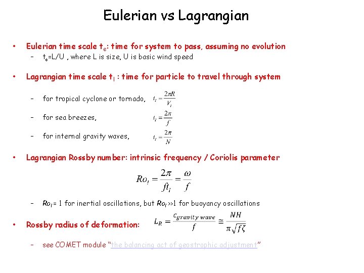
Eulerian vs Lagrangian • • • Eulerian time scale te: time for system to pass, assuming no evolution – Lagrangian time scale tl : time for particle to travel through system – for tropical cyclone or tornado, – for sea breezes, – for internal gravity waves, Lagrangian Rossby number: intrinsic frequency / Coriolis parameter – • te=L/U , where L is size, U is basic wind speed Rol = 1 for inertial oscillations, but Rol >>1 for buoyancy oscillations Rossby radius of deformation: – see COMET module “the balancing act of geostrophic adjustment”

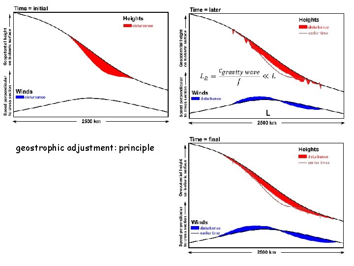
L geostrophic adjustment: principle

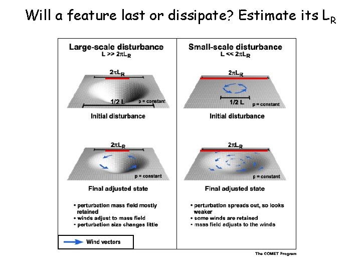
Will a feature last or dissipate? Estimate its LR

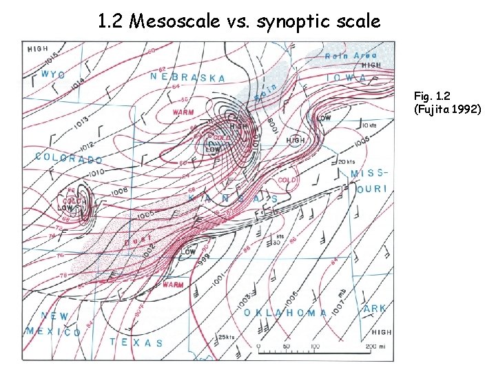
1. 2 Mesoscale vs. synoptic scale Fig. 1. 2 (Fujita 1992)

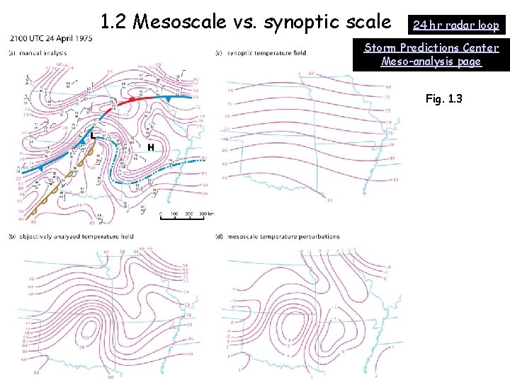
1. 2 Mesoscale vs. synoptic scale 24 hr radar loop Storm Predictions Center Meso-analysis page Fig. 1. 3

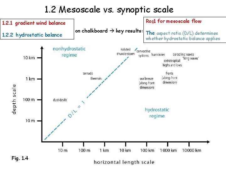
1. 2 Mesoscale vs. synoptic scale 1. 2. 1 gradient wind balance 1. 2. 2 hydrostatic balance Fig. 1. 4 Ro≥ 1 for mesoscale flow on chalkboard key results: The aspect ratio (D/L) determines whether hydrostatic balance applies

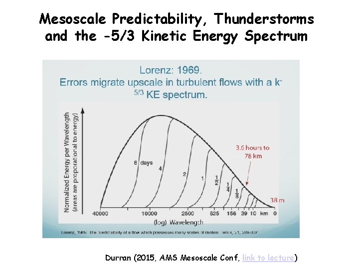
Mesoscale Predictability, Thunderstorms and the -5/3 Kinetic Energy Spectrum Durran (2015, AMS Mesoscale Conf, link to lecture)

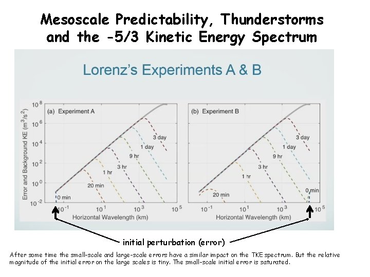
Mesoscale Predictability, Thunderstorms and the -5/3 Kinetic Energy Spectrum initial perturbation (error) After some time the small-scale and large-scale errors have a similar impact on the TKE spectrum. But the relative magnitude of the initial error on the large scales is tiny. The small-scale initial error is saturated.

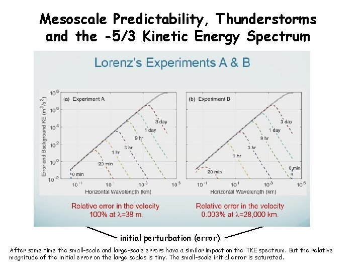
Mesoscale Predictability, Thunderstorms and the -5/3 Kinetic Energy Spectrum initial perturbation (error) After some time the small-scale and large-scale errors have a similar impact on the TKE spectrum. But the relative magnitude of the initial error on the large scales is tiny. The small-scale initial error is saturated.

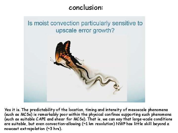
conclusion: Yes it is. The predictability of the location, timing and intensity of mesoscale phenomena (such as MCSs) is remarkably poor within the physical confines supporting such phenomena (such as suitable CAPE and shear for MCSs). That is, we can say that large-scale conditions are suitable, but even convection-allowing (~1 km resolution) NWP has little skill beyond a nowcast extrapolation (~3 hrs).