Rainfall data are from http www ncdc noaa


- Slides: 16
Rainfall data are from http: //www. ncdc. noaa. gov/cag/time-series/us/33/4/pcp/1/7/18952016? base_prd=true&firstbaseyear=1901&lastbaseyear=2000&trend=true&trend_base=10&firsttrendyear=1895&lasttrendyear=2016 for north central (Rock Creek) and northeast (Big Creek) Ohio. Runoff data are derived from U. S. Geological Survey streamflow data from http: //waterdata. usgs. gov/nwis/uv? site_no=12334510 (Rock Creek) and http: //waterdata. usgs. gov/oh/nwis/uv? site_no=04208502 (Big Creek).
Rainfall data are from http: //www. ncdc. noaa. gov/cag/time-series/us/33/4/pcp/1/7/18952016? base_prd=true&firstbaseyear=1901&lastbaseyear=2000&trend=true&trend_base=10&firsttrendyear=1895&lasttrendyear=2016 for north central (Rock Creek) and northeast (Big Creek) Ohio. Runoff data are derived from U. S. Geological Survey streamflow data from http: //waterdata. usgs. gov/nwis/uv? site_no=12334510 (Rock Creek) and http: //waterdata. usgs. gov/oh/nwis/uv? site_no=04208502 (Big Creek).
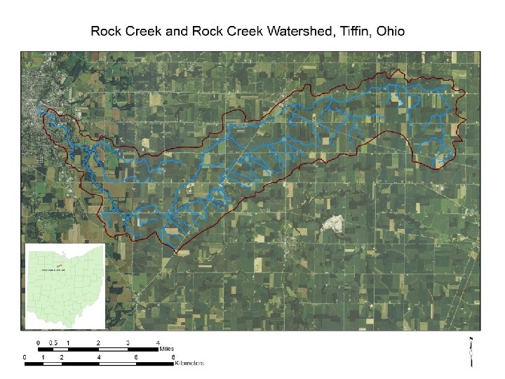
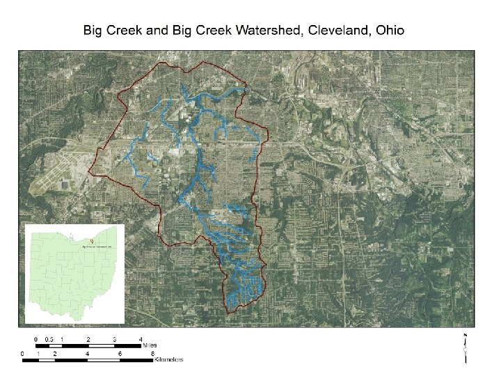
Rock Creek at Tiffin OH USGS Gaging Station 04197170 Lat 41° 06'49", long 83° 10'06“ Seneca County, OH Hydrologic Unit 04100011 Drainage area 34. 6 mi 2 Realtime Stage and Discharge Data: Rock Creek at Tiffin Ohio U. S. Geological Survey station data from http: //waterdata. usgs. gov/nwis/uv? site_no=12334510 Big Creek at Cleveland OH USGS Gaging Station 04208502 Latitude 41° 27'01", Longitude 81° 43'18" Cuyahoga County, Ohio Hydrologic Unit Code 04110002 Drainage area 35. 3 mi 2 Realtime Stage Data: Big Creek at Cleveland Ohio U. S. Geological Survey station data from http: //waterdata. usgs. gov/oh/nwis/uv? site_no=04208502
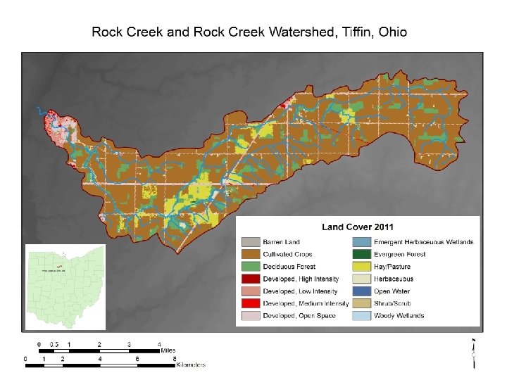
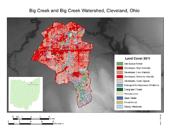
Valu e 11 Open Water - areas of open water, generally with less than 25% cover of vegetation or soil. 12 Perennial Ice/Snow - areas characterized by a perennial cover of ice and/or snow, generally greater than 25% of total cover. 21 Developed, Open Space - areas with a mixture of some constructed materials, but mostly vegetation in the form of lawn grasses. Impervious surfaces account for less than 20% of total cover. These areas most commonly include large-lot single-family housing units, parks, golf courses, and vegetation planted in developed settings for recreation, erosion control, or aesthetic purposes. 22 Developed, Low Intensity - areas with a mixture of constructed materials and vegetation. Impervious surfaces account for 20% to 49% percent of total cover. These areas most commonly include single-family housing units. 23 Developed, Medium Intensity – areas with a mixture of constructed materials and vegetation. Impervious surfaces account for 50% to 79% of the total cover. These areas most commonly include single-family housing units. 24 Developed High Intensity -highly developed areas where people reside or work in high numbers. Examples include apartment complexes, row houses and commercial/industrial. Impervious surfaces account for 80% to 100% of the total cover. 31 Barren Land (Rock/Sand/Clay) - areas of bedrock, desert pavement, scarps, talus, slides, volcanic material, glacial debris, sand dunes, strip mines, gravel pits and other accumulations of earthen material. Generally, vegetation accounts for less than 15% of total cover. 41 Deciduous Forest - areas dominated by trees generally greater than 5 meters tall, and greater than 20% of total vegetation cover. More than 75% of the tree species shed foliage simultaneously in response to seasonal change. 42 Evergreen Forest - areas dominated by trees generally greater than 5 meters tall, and greater than 20% of total vegetation cover. More than 75% of the tree species maintain their leaves all year. Canopy is never without green foliage. Forest Barren Developed Clas s Water 1 National Land Cover Database Classification Description adapted from legends and descriptions for the NLCD available from http: //www. mrlc. gov/index. php. Mixed Forest - areas dominated by trees generally greater than 5 meters tall, and
1 National Land Cover Database Classification Descript Valu e Shrubland 51 Dwarf Scrub - Alaska only areas dominated by shrubs less than 20 centimeters tall with shrub canopy typically greater than 20% of total vegetation. This type is often co-associated with grasses, sedges, herbs, and non-vascular vegetation. 52 Shrub/Scrub - areas dominated by shrubs; less than 5 meters tall with shrub canopy typically greater than 20% of total vegetation. This class includes true shrubs, young trees in an early successional stage or trees stunted from environmental conditions. 71 Grassland/Herbaceous - areas dominated by gramanoid or herbaceous vegetation, generally greater than 80% of total vegetation. These areas are not subject to intensive management such as tilling, but can be utilized for grazing. 72 Sedge/Herbaceous - Alaska only areas dominated by sedges and forbs, generally greater than 80% of total vegetation. This type can occur with significant other grasses or other grass like plants, and includes sedge tundra, and sedge tussock tundra. 73 Lichens - Alaska only areas dominated by fruticose or foliose lichens generally greater than 80% of total vegetation. 74 Moss - Alaska only areas dominated by mosses, generally greater than 80% of total vegetation. Planted/ Cultivated 81 Pasture/Hay – areas of grasses, legumes, or grass-legume mixtures planted for livestock grazing or the production of seed or hay crops, typically on a perennial cycle. Pasture/hay vegetation accounts for greater than 20% of total vegetation. 82 Cultivated Crops – areas used for the production of annual crops, such as corn, soybeans, vegetables, tobacco, and cotton, and also perennial woody crops such as orchards and vineyards. Crop vegetation accounts for greater than 20% of total vegetation. This class also includes all land being actively tilled. 90 Herbaceous Clas s ands (cont. ) Classification Description (cont. ) Woody Wetlands - areas where forest or shrubland vegetation accounts for greater than 20% of vegetative cover and the soil or substrate is periodically adapted from legends and descriptions for the NLCD available from http: //www. mrlc. gov/index. php. saturated with or covered with water.
2011 Land Cover in the Rock Creek and Big Creek Watersheds
Rate of Farmland Conversion to Non-farming Uses 1982 -2007 >2500 acres/day* (a cumulative area the size of Indiana) * Data are from American Farmland
from Stream Corridor Restoration, produced by the Federal Interagency Stream Restoration Working Group
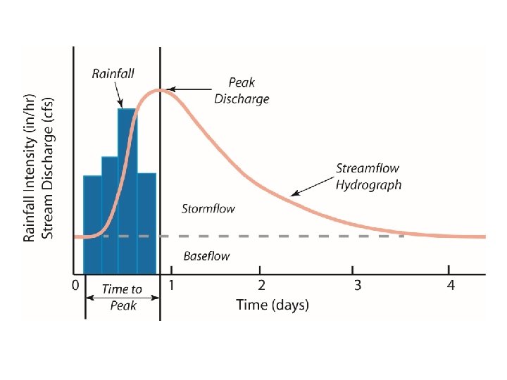
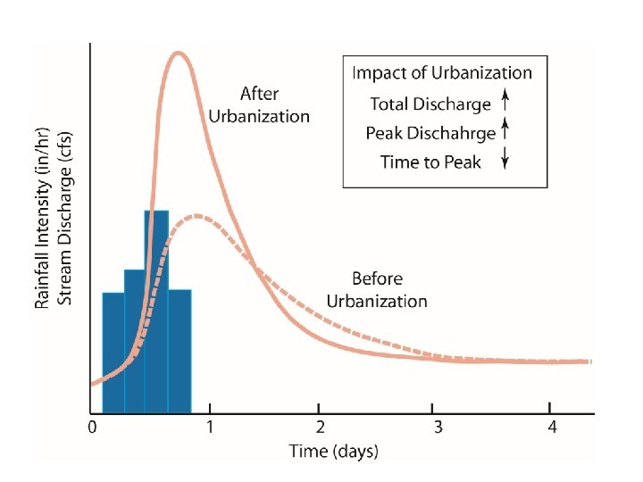
ET Watershed System Soil Erosion - - Precipitation Vegetation Density + Impervious Cover Infiltration Capacity Runoff - Soil Moisture or Groundwater Input Storage (or Stock) Output
ET Watershed System Soil Erosion - - Precipitation Vegetation Density + Impervious Cover Infiltration Capacity Runoff - Soil Moisture or Groundwater Input Storage (or Stock) Output