National Weather Service Office of Science Technology Perspective
- Slides: 23

National Weather Service Office of Science & Technology Perspective on Future Enterprise Observing Systems Mike Johnson Don Berchoff, Director Paula Davidson, Pete Roohr Office of Science & Technology National Weather Service 2 February 2010

Overview Describe NWS/OST Perspective on future enterprise observing systems ØRequirements Process ØNWS Science & Technology Roadmap ØSummary

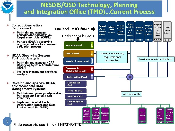
NESDIS/OSD Technology, Planning and Integration Office (TPIO)…Current Process Goals and Sub-Goals Ø NOAA Observing System Portfolio Analysis Ø Maintain and manage NOAA Observing System Architecture (NOSA) Ø Perform investment portfolio analysis Ø Develop and Analyze NOAA Environmental Data Management Systems Ø Maintain and manage Information Management System (IMS) inventory Ø Implement Global Earth Observation-Integrated Data Environment (GEO-IDE) 3 Goals and Sub-Goals NOAA Program National Oceanic Satellite National Analysis Planning & Atmos. Marine Ocean And & Weather & Intepheric Fisheries Service Info. Eval. Service gration Research Service uation NOS OAR NESDIS NWS PPI Chief Financial Officer PA & E CFO EC NMFS Ecosystem Goal CL Consolidated Observation Requirement List (CORL) Ø Manage NOAA’s observing requirement verification and validation process Climate Goal Weather & Water Goal WW Ø Maintain and manage Line and Staff Offices Commerce & Transportation Goal CT Requirements Mission Support Goal MS Ø Collect Observation Manage observing requirements process for Provide analysis products to Satellite Sub. Goal Fleet Sub-Goal Interface with MOBI Sub-Goal Leadership Sub. Goal Councils Slide excerpts courtesy of NESDIS/TPIO NOAA Observing Research Ocean Systems Council NOC NOSC Research Fleet Council Chief Info. Officer Council Chief Financial Officer Council FC CIO CFO

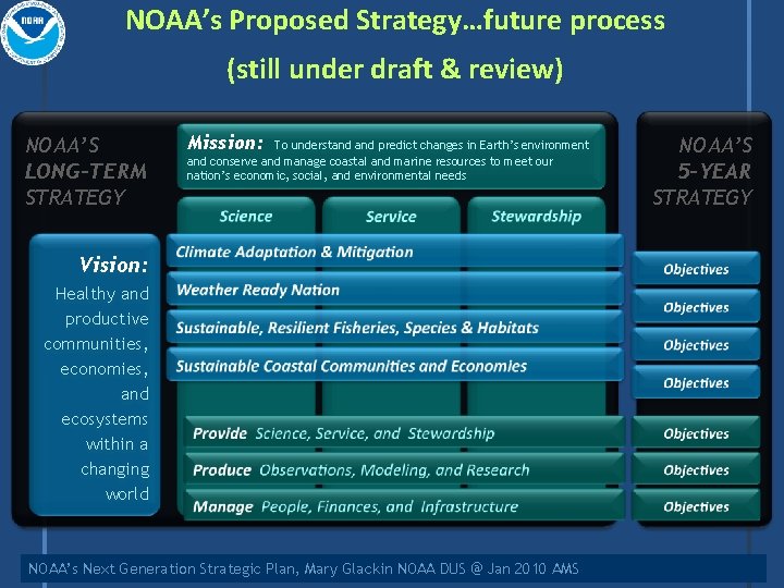
NOAA’s Proposed Strategy…future process (still under draft & review) NOAA’S LONG-TERM STRATEGY Mission: To understand predict changes in Earth’s environment and conserve and manage coastal and marine resources to meet our nation’s economic, social, and environmental needs Vision: Healthy and productive communities, economies, and ecosystems within a changing world NOAA’s Next Generation Strategic Plan, Mary Glackin NOAA DUS @ Jan 2010 AMS NOAA’S 5 -YEAR STRATEGY

Overview Describe NWS/OST Perspective on future enterprise observing systems ØRequirements Process ØNWS Science & Technology Roadmap ØSummary

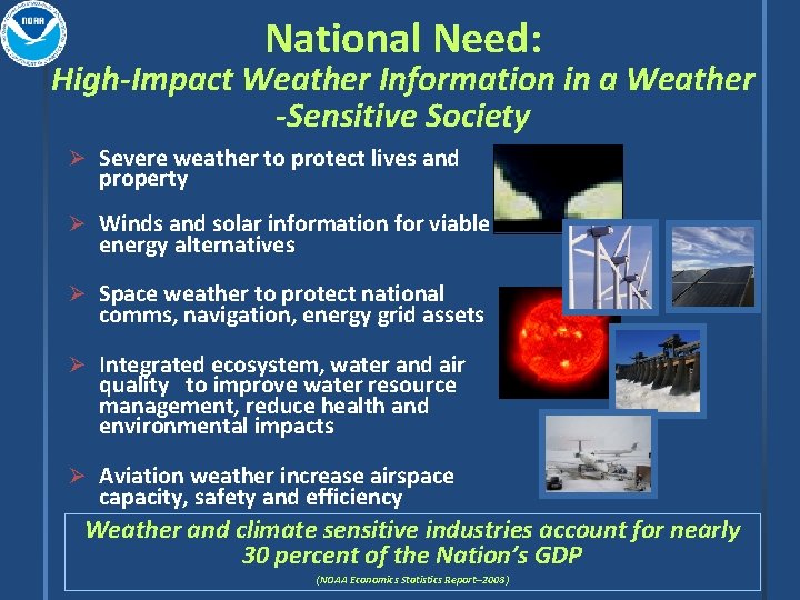
National Need: High-Impact Weather Information in a Weather -Sensitive Society Ø Severe weather to protect lives and property Ø Winds and solar information for viable energy alternatives Ø Space weather to protect national comms, navigation, energy grid assets Ø Integrated ecosystem, water and air quality to improve water resource management, reduce health and environmental impacts Ø Aviation weather increase airspace capacity, safety and efficiency Weather and climate sensitive industries account for nearly 30 percent of the Nation’s GDP (NOAA Economics Statistics Report--2008)

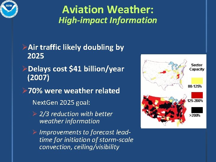
Aviation Weather: High-impact Information ØAir traffic likely doubling by 2025 Baseline Demand Sector Capacity ØDelays cost $41 billion/year (2007) Ø 70% were weather related Next. Gen 2025 goal: Ø 2/3 reduction with better weather information Ø Improvements to forecast lead- time for initiation of storm-scale convection, ceiling/visibility 80 -125% Future Demand 125 -200% >200%

NWS/OS&T Mission Drive S&T Advances into NWS Operations Ø Respond to Field Requirements and Emerging Opportunities (user pull and S&T push balance) Ø Plan, Develop, and Implement Enterprise Solutions Ø Focused on the greatest need and payback to the Nation Ø Future: high-performance computing, cloud computing, next- generation collaboration/dissemination technologies, etc Ø Enable Continuous Improvement…with Ø Better, faster, and more cost effective solutions during austere budget era Ø Architectures for agile, rapid S&T insertion and reduced IT footprints Ø Partnerships-- transformational and emerging S&T beyond horizon

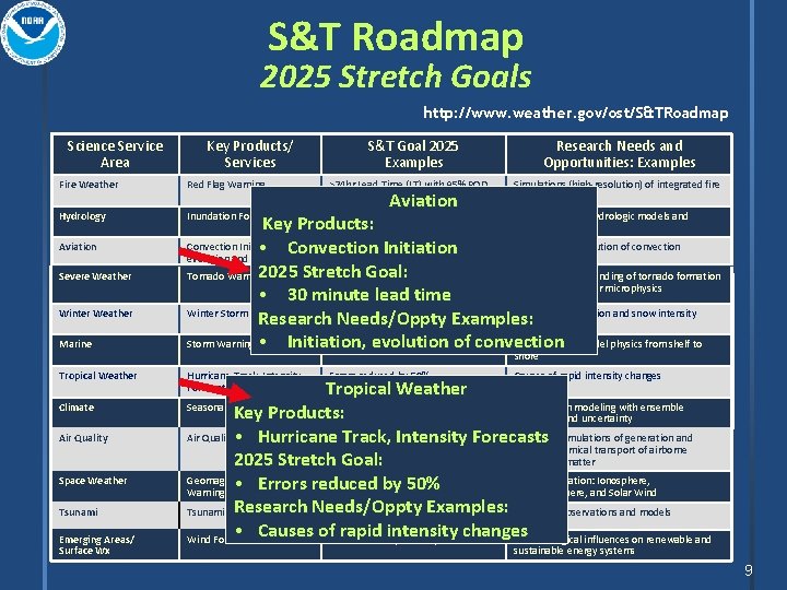
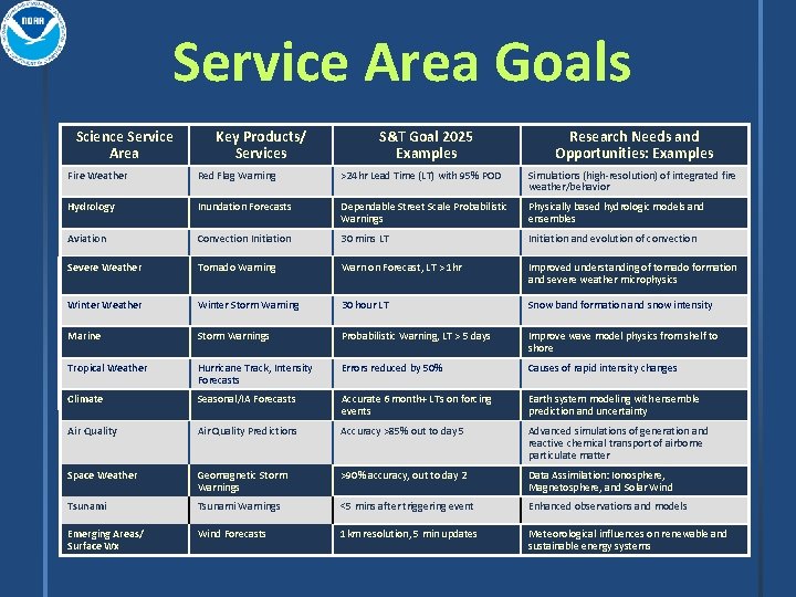
S&T Roadmap 2025 Stretch Goals http: //www. weather. gov/ost/S&TRoadmap Science Service Area Key Products/ Services S&T Goal 2025 Examples Research Needs and Opportunities: Examples Fire Weather Red Flag Warning >24 hr Lead Time (LT) with 95% POD Simulations (high-resolution) of integrated fire weather/behavior Hydrology Inundation Forecasts Dependable Street Scale Probabilistic Warnings Physically based hydrologic models and Aviation Severe Weather Winter Weather Marine Tropical Weather Climate Air Quality Space Weather Tsunami Emerging Areas/ Surface Wx Aviation Key Products: ensembles Convection Initiation, 30 mins LT Initiation and evolution of convection • Convection Initiation evolution and dissipation 2025 Stretch Goal: Tornado Warning Warn on Forecast, LT > 1 hr Improved understanding of tornado formation and severe weather microphysics • 30 minute lead time Winter Storm Hazards Warning High-Res 30 hour LTUser-Defined Thresholds Snow band formation and snow intensity Research Needs/Oppty Examples: Storm Warnings • Initiation, evolution of convection Probabilistic Warning, LT > 5 days Improve wave model physics from shelf to shore Hurricane Track, Intensity Forecasts Errors reduced by 50% Causes of rapid intensity changes Tropical Weather Accurate 6 probabilistic Accurate, month+ LTs 6 on month+ forcing. LTs Earth system modeling with ensemble Key Products: events on forcing events prediction and uncertainty Air Quality • Predictions Accuracy >85% out to day 5 Advanced simulations of generation and Hurricane Track, Intensity Forecasts reactive chemical transport of airborne particulate matter 2025 Stretch Goal: Geomagnetic >90% accuracy, out to day 2 Data Assimilation: Ionosphere, • Storm Errors reduced by 50% Warnings Magnetosphere, and Solar Wind Research Needs/Oppty Examples: Tsunami Warnings <5 mins after triggering event Enhanced observations and models • Causes of rapid intensity changes Wind Forecasts 1 km resolution, 5 min updates Meteorological influences on renewable and Seasonal/IA Forecasts sustainable energy systems 9

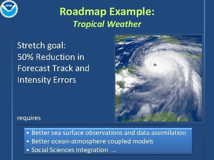
Roadmap Example: Tropical Weather Stretch goal: 50% Reduction in Forecast Track and Intensity Errors requires • Better sea surface observations and data assimilation • Better ocean-atmosphere coupled models • Social Sciences integration …

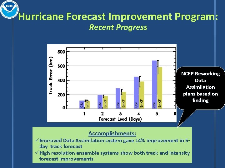
Hurricane Forecast Improvement Program: Recent Progress NCEP Reworking Data Assimilation plans based on finding Accomplishments: ü Improved Data Assimilation system gave 14% improvement in 5 - day track forecast ü High resolution ensemble systems show both track and intensity forecast improvements

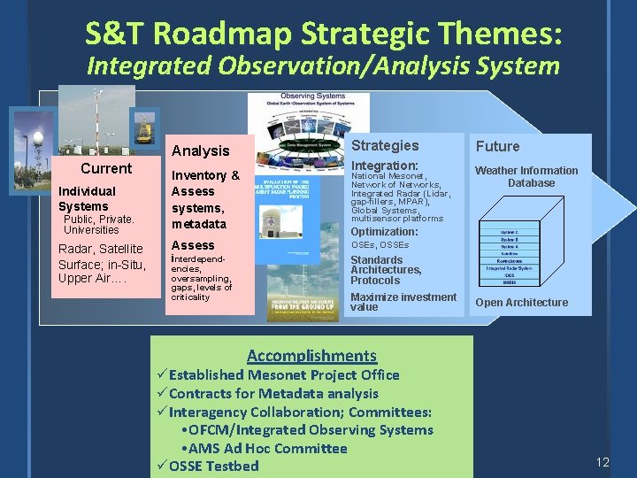
S&T Roadmap Strategic Themes: Integrated Observation/Analysis System Analysis Current Individual Systems Public, Private. Universities Radar, Satellite Surface; in-Situ, Upper Air…. Inventory & Assess systems, metadata Assess interdepend- encies, oversampling, gaps, levels of criticality Strategies Integration: National Mesonet, Network of Networks, Integrated Radar (Lidar, gap-fillers, MPAR), Global Systems, multisensor platforms Future Weather Information Database Optimization: OSEs, OSSEs Standards Architectures, Protocols Maximize investment value Open Architecture Accomplishments üEstablished Mesonet Project Office üContracts for Metadata analysis üInteragency Collaboration; Committees: • OFCM/Integrated Observing Systems • AMS Ad Hoc Committee üOSSE Testbed 12

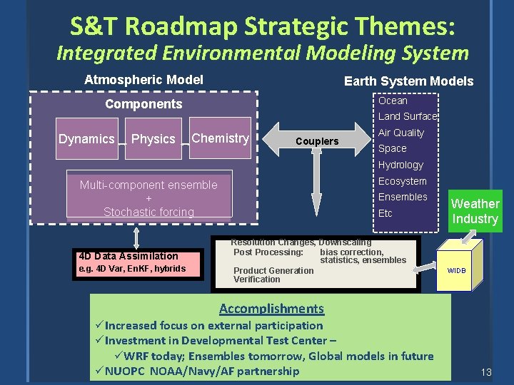
S&T Roadmap Strategic Themes: Integrated Environmental Modeling System Atmospheric Model Earth System Models Ocean Components Dynamics Physics Land Surface Chemistry Couplers Air Quality Space Hydrology Ecosystem Multi-component ensemble + Stochastic forcing 4 D Data Assimilation e. g. 4 D Var, En. KF, hybrids Ensembles Etc Resolution Changes, Downscaling Post Processing: bias correction, statistics, ensembles Product Generation Verification Weather Industry WIDB Accomplishments ü Increased focus on external participation ü Investment in Developmental Test Center – üWRF today; Ensembles tomorrow, Global models in future ü NUOPC NOAA/Navy/AF partnership 13

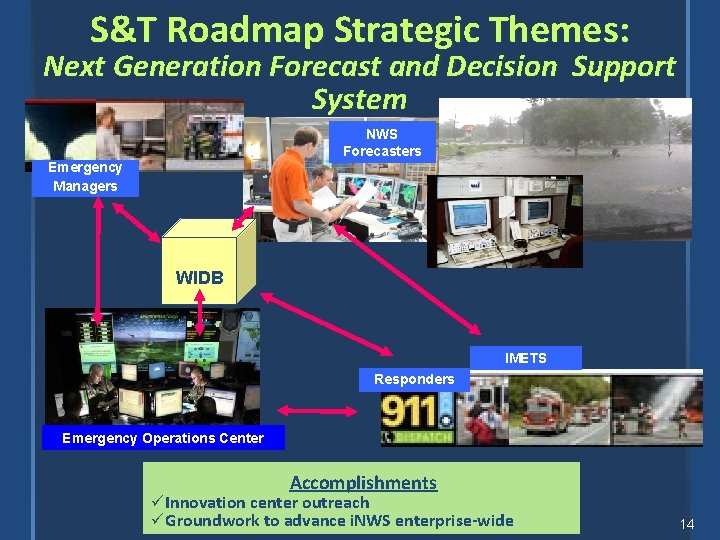
S&T Roadmap Strategic Themes: Next Generation Forecast and Decision Support System NWS Forecasters Emergency Managers WIDB IMETS Responders Emergency Operations Center Accomplishments ü Innovation center outreach ü Groundwork to advance i. NWS enterprise-wide 14

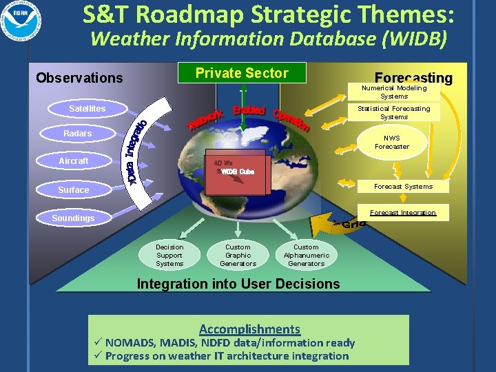
S&T Roadmap Strategic Themes: Weather Information Database (WIDB) Private Sector Observations Forecasting Numerical Modeling Systems Satellites Statistical Forecasting Systems Radars NWS Forecaster Aircraft 4 D Wx SAS WIDB Cube Forecast Systems Surface Forecast Integration Soundings Decision Support Systems Custom Graphic Generators Custom Alphanumeric Generators Integration into User Decisions Accomplishments ü NOMADS, MADIS, NDFD data/information ready ü Progress on weather IT architecture integration

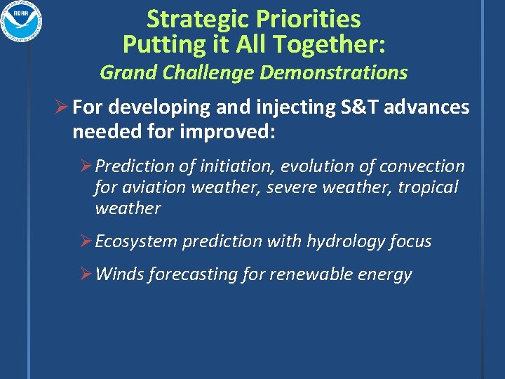
Strategic Priorities Putting it All Together: Grand Challenge Demonstrations Ø For developing and injecting S&T advances needed for improved: Ø Prediction of initiation, evolution of convection for aviation weather, severe weather, tropical weather Ø Ecosystem prediction with hydrology focus Ø Winds forecasting for renewable energy

Overview Describe NWS/OST Perspective on future enterprise observing systems ØRequirements Process ØNWS Science & Technology Roadmap ØSummary

Summary ØRequirements process defines observation needs to meet strategic goals ØRequirements process is changing ØNWS Science & Technology Roadmap defines NWS strategic goals ØThese goals are used as context for prioritizing observation needs to fill weather & water goals

Questions? email: nwsostroadmap@noaa. gov

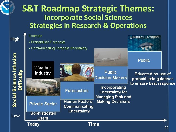
S&T Roadmap Strategic Themes: Incorporate Social Sciences Strategies in Research & Operations High Example • Probabilistic Forecasts Social Science Infusion Difficulty • Communicating Forecast Uncertainty Low Public Weather Industry Private Sector Sophisticated Users Today Public Decision Makers Educated on use of probabilistic guidance to ensure best response Incorporating Forecasters Uncertainty for Managing Risk and Human Factors, Making Decisions Communicating Uncertainty Time 20

Service Area Goals Science Service Area Key Products/ Services S&T Goal 2025 Examples Research Needs and Opportunities: Examples Fire Weather Red Flag Warning >24 hr Lead Time (LT) with 95% POD Simulations (high-resolution) of integrated fire weather/behavior Hydrology Inundation Forecasts Dependable Street Scale Probabilistic Warnings Physically based hydrologic models and ensembles Aviation Convection Initiation 30 mins LT Initiation and evolution of convection Severe Weather Tornado Warning Warn on Forecast, LT > 1 hr Improved understanding of tornado formation and severe weather microphysics Winter Weather Winter Storm Hazards Warning High-Res 30 hour LTUser-Defined Thresholds Snow band formation and snow intensity Marine Storm Warnings Probabilistic Warning, LT > 5 days Improve wave model physics from shelf to shore Tropical Weather Hurricane Track, Intensity Forecasts Errors reduced by 50% Causes of rapid intensity changes Climate Seasonal/IA Forecasts Accurate 6 month+ LTs on forcing events Earth system modeling with ensemble prediction and uncertainty Air Quality Predictions Accuracy >85% out to day 5 Advanced simulations of generation and reactive chemical transport of airborne particulate matter Space Weather Geomagnetic Storm Warnings >90% accuracy, out to day 2 Data Assimilation: Ionosphere, Magnetosphere, and Solar Wind Tsunami Warnings <5 mins after triggering event Enhanced observations and models Emerging Areas/ Surface Wx Wind Forecasts 1 km resolution, 5 min updates Meteorological influences on renewable and sustainable energy systems

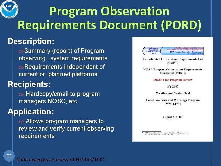
Program Observation Requirements Document (PORD) Description: Summary (report) of Program observing system requirements Requirements independent of current or planned platforms Recipients: Hardcopy/email to program managers, NOSC, etc Application: Allows program managers to review and verify current observing requirements 22 Slide excerpts courtesy of NESDIS/TPIO

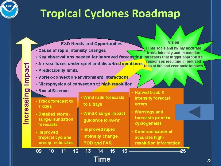
Tropical Cyclones Roadmap Vision R&D Needs and Opportunities Finer scale and highly accurate track, intensity and inundation • Key observations needed for improved forecasting forecasts that trigger appropriate responses resulting in reduced • Air-sea fluxes under quiet and disturbed conditions loss of life and economic impacts Increasing Impact • Cause of rapid intensity changes • Predictability limits • Vortex-convection-environment interactions • Microphysics of convection at high-resolution • Social Science • Halved track & • Track forecast to 7 days surge/inundation forecasts guidance to 36 -hr • Improved rapid • Improved tropical cyclone precip. estimates 10 to 5 days • Wind& surge impact • Detailed storm- 09 • Wind radii forecasts 11 12 15 Time forecasts prior to cyclogenesis accurate highresolution information POD and FAR 14 • Warnings and • Communication of intensity change, 13 intensity forecast errors 16 25 23