National Weather Service Weather Forecast Office Mobile Pensacola

National Weather Service Weather Forecast Office Mobile - Pensacola Special Update Tropical Storm Isaac Jeff Garmon Warning Coordination Meteorologist 10 AM CDT Tuesday 28 August 2012

NWS Mobile / Pensacola Special Briefing NEW NUMBER • Please call: • 1 -866 -764 -3542 • Conference ID #: 25349953 • We had to increase the number of lines to accommodate the number of participants.

This outlook is intended for interests across interior southeast Mississippi, south Alabama, the western Florida Panhandle, and the adjacent Gulf coastal waters of Alabama and northwest Florida

Satellite Image TS Isaac

Latest Observations… • Satellite imagery continues to show a slow trend of Isaac strengthening towards hurricane strength…however winds remain close to hurricane strength sustained at 70 mph close to the center. • Tropical storm force winds (39 -73 mph) extend outward from the center for 200 miles. • Isaac is moving northwest at 10 mph. Although a little slower…Isaac has maintained this northwest motion for the past 24 hours. No turn to the north expected here in the short term…Hurricane Warnings for Mobile and Baldwin being replaced by Tropical Storm Warnings at 10 AM CDT. • Isaac is now centered due south of Dauphin Island.

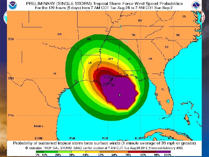
Tropical Storm Force Winds Extend North and Eastward from the Center for 200 Miles

Forecast Track Impacts extend well outside the cone. The cone represents (based on average track error, where the CENTER of the hurricane will be 2/3 rds of the time. Tropical storm force winds extend eastward for 200 miles.

Warnings and Watches in Effect Hurricane Warning for Mobile and Baldwin being was replaced by Tropical Storm Warning at 10 AM…THAT DOES NOT MEAN LESS STORM SURGE EXPECTED.

Coastal Flood Considerations Storm Tide of 5 to 8 Feet Mobile and Baldwin, and 4 to 6 along the western Florida panhandle

Wind Impact Considerations

Forecast Sustained Wind Envelope Tue PM-Wed PM Winds <39 mph Winds 39 -57 mph >73 mph Winds 58 -73 mph Main areas to expect minor structural damage, downed trees and power outages are: • Mobile, Baldwin, Stone, George, Greene, and Perry counties. • Southern exposed areas of Escambia, Santa Rosa and Okaloosa counties will see periodic gusts to tropical storm force with passing rain squalls. Timing of onset of TS force winds: • Now through Wednesday Mobile-Baldwin and coastal areas of the western Florida panhandle. • Late afternoon into the evening for interior SE Mississippi counties.

Tornado Risk • We are looking at a risk for isolated tornadoes today through Wednesday. • We will need to watch for stronger storms in bands on the east side of Isaac. • As these bands move across gusts to 60 mph may be possible… especially along the coastal counties.

Heavy Rain Threat Through Wednesday • Overall, 8 to locally 12 inches of rainfall is expected from Isaac over SE Mississippi. Lower amounts around 4 inches are expected over south central AL and the western Florida panhandle. • Greatest risk for flash flooding will be over SW Alabama and SE Mississippi. Greatest Risk for Flash Flooding

Main Points to Consider… • Current projections indicate a category 1 hurricane at landfall in SE Louisiana. • Tropical storm force winds will affect interior Stone, George, Perry, Wayne and Greene counties of SE Mississippi…and Washington…Mobile and Baldwin counties in SW Alabama. • Conditions along the coast will continue to deteriorate today with storm surge gradually increasing. • Even though the Hurricane Warning on the coast has been downgraded to a Tropical Storm Warning…THIS DOES NOT MEAN WE WILL GET LESS STORM SURGE. • We are still expecting storm surge values tonight into Wednesday of 6 to 8 feet of inundation around the Alabama coast and 3 to 6 feet on the western Florida panhandle. • There is a chance that 8 to 10 inches of rain could fall over portions of our area Tuesday into Wednesday. This would result in an increased risk of freshwater flooding by Wednesday. A flash flood watch has been issued for part of the area. • Isolated tornado risk will increase this afternoon through tonight across the area.

To Contact NWS Mobile • Phone… – Public: 1 -800 -284 -9059 – Forecast Desk – Briefings (unlisted): 251 -633 -2471 • Web… – weather. gov/mob • Facebook… – www. facebook. com/US. National. Weather. Service. Mobile. gov • Twitter… – @NWSMobile
- Slides: 18