National Weather Service Weather Forecast Office Mobile Pensacola

National Weather Service Weather Forecast Office Mobile – Pensacola Weather Briefing Mid to Late Week Heavy Rain & Flood Threat Tuesday August 9, 2016 230 PM CDT NWSMobile weather. gov/mob

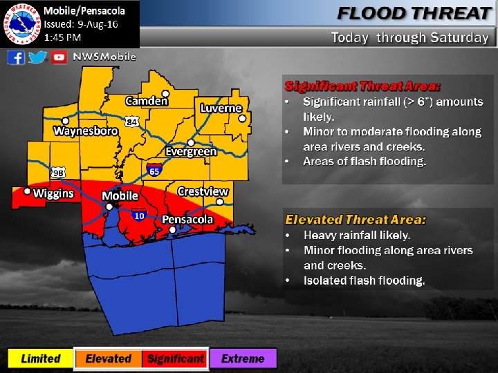
Situation Overview • New Information: • A Flash Flood Watch is now in effect for southern portions of the area. • While forecast rain totals are lower than yesterday, potential still exists for locally up to 12” of rain in the watch area. • What/When: • Today: Locally heavy rain/localized flooding • Wednesday - Friday: Greatest threat for heavy rain/flooding. High risk of rip currents along the coast. • Saturday – Sunday: Localized heavy rain still likely, especially over SW AL/SE MS. Extent of weekend threat is still a bit uncertain. • Where: • Greatest concern NW FL, coastal AL, and parts of SE MS. • Confidence: • High - Overall likelihood of heavy rain and areas of greatest threat • Moderate – Location and areal coverage of highest rain totals Do not focus on the storm total rainfall map, focus on the threat area/potential impacts map. NWSMobile weather. gov/mob

Flash Flood Watch In Effect Through Friday Morning Current watch area highlights the area of greatest concern for flooding. Adjustments possible as the event evolves. NWSMobile weather. gov/mob

Rainfall Forecast Through Saturday A heavy rain event is expected across the area, especially closer to the coast. Areas of flooding are likely. Locally higher totals double the amounts shown on the map are possible. NWSMobile weather. gov/mob

River Flooding Potential Based on the current rain forecast, flooding possible along the quick response rivers of colored in yellow or orange. *This assumes the rainfall is spread out over a long duration* River responses will likely be more significant where high rain totals occur over a shorter period of time (this is often the case in these type of events) NWSMobile weather. gov/mob

Next Briefing Packet will be sent by 8 am Wednesday morning. Next webinar: tentatively scheduled for 230 pm Wednesday, August 10 th
- Slides: 7