Improved highimpact weather HRRRRAP forecast accuracy from assimilation

- Slides: 39
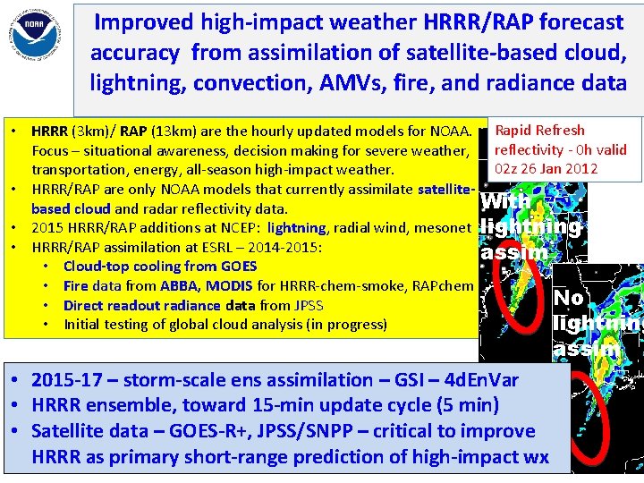
Improved high-impact weather HRRR/RAP forecast accuracy from assimilation of satellite-based cloud, lightning, convection, AMVs, fire, and radiance data Stan Benjamin, Steve Weygandt, Haidao Lin, Curtis Alexander, Ming Hu, Tracy Lorraine Smith NOAA/ESRL/GSD, Boulder, CO Rapid Refresh reflectivity - 0 h valid 02 z 26 Jan 2012 Outline With • HRRR (3 km)/ RAP (13 km) are the hourly updated models for NOAA. Focus – situational awareness, decision making for severe weather, lightning assim transportation, energy, all-season high-impact weather. • HRRR/RAP are only NOAA models that currently assimilate satellitebased cloud and radar reflectivity data. No • 2015 HRRR/RAP additions at NCEP: lightning, radial wind, mesonet lightning • HRRR/RAP assimilation at ESRL – 2014 -2015: assim • Cloud-top cooling from GOES • Fire data from ABBA, MODIS for HRRR-chem-smoke, RAPchem • Direct readout radiance data from JPSS • Initial testing of global cloud analysis (in progress) • Results from RAP OSEs (obs sensitivity experiments) from radiances and observations NOAA Satellite Science Week – 24 Feb 2015
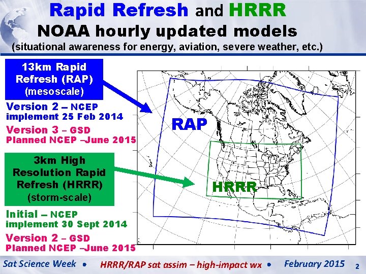
Rapid Refresh and HRRR NOAA hourly updated models (situational awareness for energy, aviation, severe weather, etc. ) 13 km Rapid Refresh (RAP) (mesoscale) Version 2 -- NCEP implement 25 Feb 2014 Version 3 – GSD Planned NCEP –June 2015 3 km High Resolution Rapid Refresh (HRRR) (storm-scale) RAP HRRR Initial -- NCEP implement 30 Sept 2014 Version 2 – GSD Planned NCEP –June 2015 Sat Science Week HRRR/RAP sat assim – high-impact wx February 2015 2
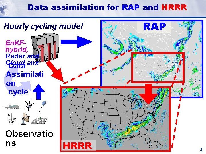
Data assimilation for RAP and HRRR Hourly cycling model RAP En. KFhybrid, Radar and Cloud anx Data Assimilati on cycle Observatio ns HRRR 3
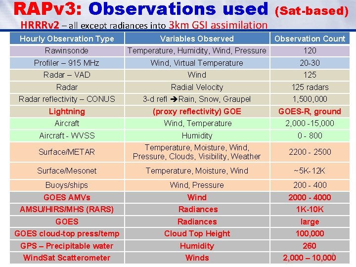
RAPv 3: Observations used HRRRv 2 – all except radiances into 3 km GSI assimilation (Sat-based) Hourly Observation Type Variables Observed Observation Count Rawinsonde Temperature, Humidity, Wind, Pressure 120 Profiler – 915 MHz Wind, Virtual Temperature 20 -30 Radar – VAD Wind 125 Radar Radial Velocity 125 radars Radar reflectivity – CONUS 3 -d refl Rain, Snow, Graupel 1, 500, 000 Lightning (proxy reflectivity) GOES-R, ground Aircraft Wind, Temperature 2, 000 -15, 000 Aircraft - WVSS Humidity 0 - 800 Surface/METAR Temperature, Moisture, Wind, Pressure, Clouds, Visibility, Weather 2200 - 2500 Surface/Mesonet Temperature, Moisture, Wind ~5 K-12 K Buoys/ships Wind, Pressure 200 - 400 GOES AMVs Wind 2000 - 4000 AMSU/HIRS/MHS (RARS) Radiances 1 K-10 K GOES Radiances large GOES cloud-top press/temp Cloud Top Height 100, 000 GPS – Precipitable water Humidity 260 Wind. Sat Scatterometer Winds 2, 000 – 10, 000 4
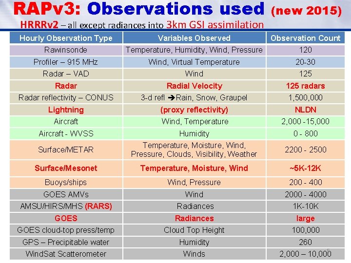
RAPv 3: Observations used HRRRv 2 – all except radiances into 3 km GSI assimilation (new 2015) Hourly Observation Type Variables Observed Observation Count Rawinsonde Temperature, Humidity, Wind, Pressure 120 Profiler – 915 MHz Wind, Virtual Temperature 20 -30 Radar – VAD Wind 125 Radar Radial Velocity 125 radars Radar reflectivity – CONUS 3 -d refl Rain, Snow, Graupel 1, 500, 000 Lightning (proxy reflectivity) NLDN Aircraft Wind, Temperature 2, 000 -15, 000 Aircraft - WVSS Humidity 0 - 800 Surface/METAR Temperature, Moisture, Wind, Pressure, Clouds, Visibility, Weather 2200 - 2500 Surface/Mesonet Temperature, Moisture, Wind ~5 K-12 K Buoys/ships Wind, Pressure 200 - 400 GOES AMVs Wind 2000 - 4000 AMSU/HIRS/MHS (RARS) Radiances 1 K-10 K GOES Radiances large GOES cloud-top press/temp Cloud Top Height 100, 000 GPS – Precipitable water Humidity 260 Wind. Sat Scatterometer Winds 2, 000 – 10, 000 5
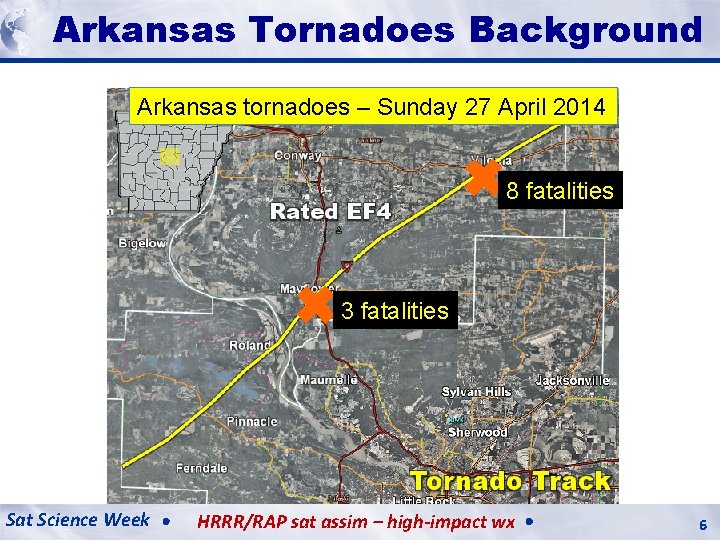
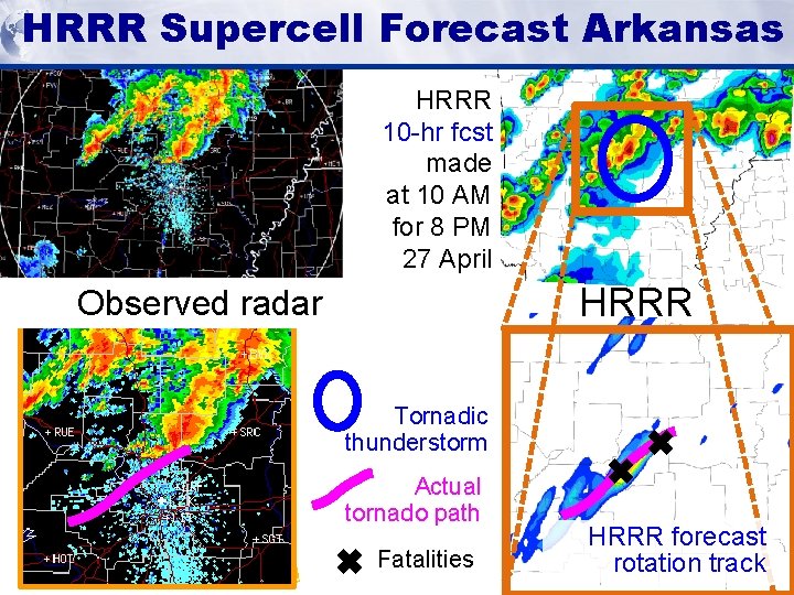
HRRR (and HRRR RAP) Milestones Future Background Milestones Arkansas Tornadoes Arkansas tornadoes – Sunday 27 April 2014 ✖ 8 fatalities ✖ 3 fatalities Sat Science Week HRRR/RAP sat assim – high-impact wx 6
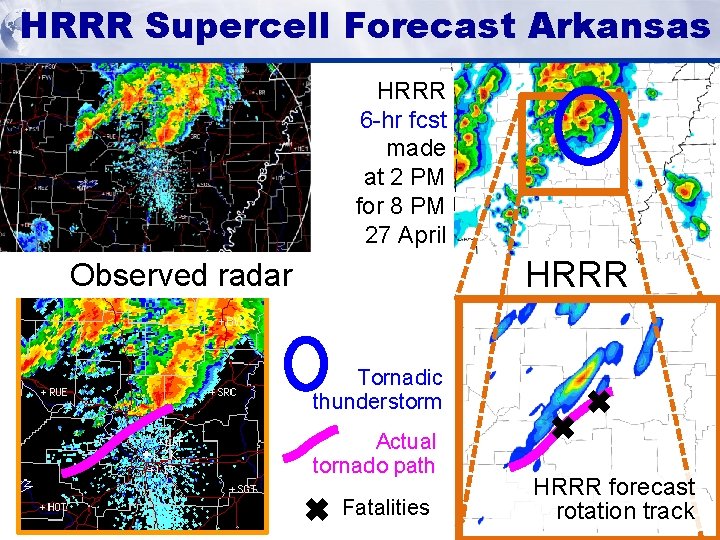
HRRR Supercell Forecast Arkansas HRRR (and HRRR RAP) Milestones Future Milestones HRRR 6 -hr fcst made at 2 PM for 8 PM 27 April HRRR Observed radar Tornadic thunderstorm Actual tornado path ✖ Fatalities ✖ ✖ HRRR forecast rotation track
HRRR Supercell Forecast Arkansas HRRR (and HRRR RAP) Milestones Future Milestones HRRR 10 -hr fcst made at 10 AM for 8 PM 27 April HRRR Observed radar Tornadic thunderstorm Actual tornado path ✖ Fatalities ✖ ✖ HRRR forecast rotation track
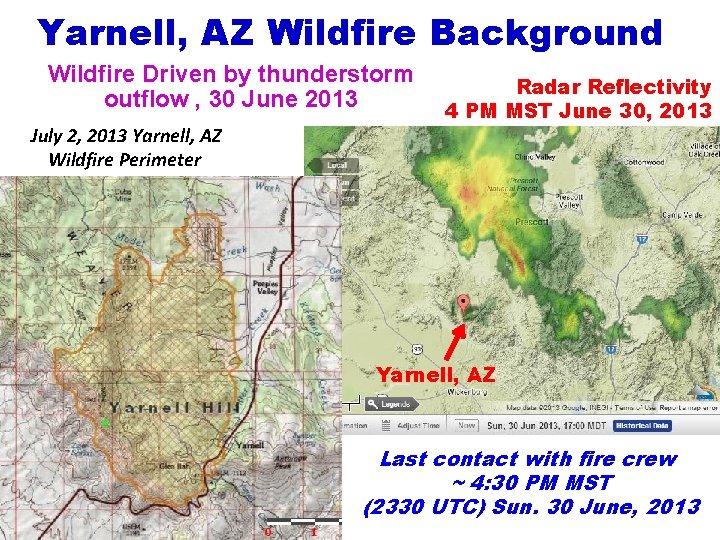
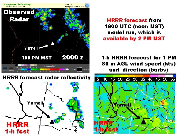
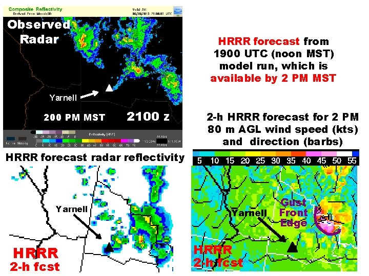
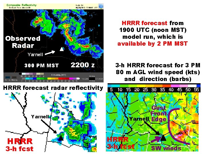
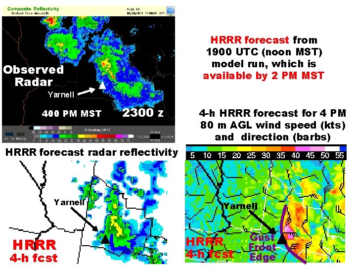
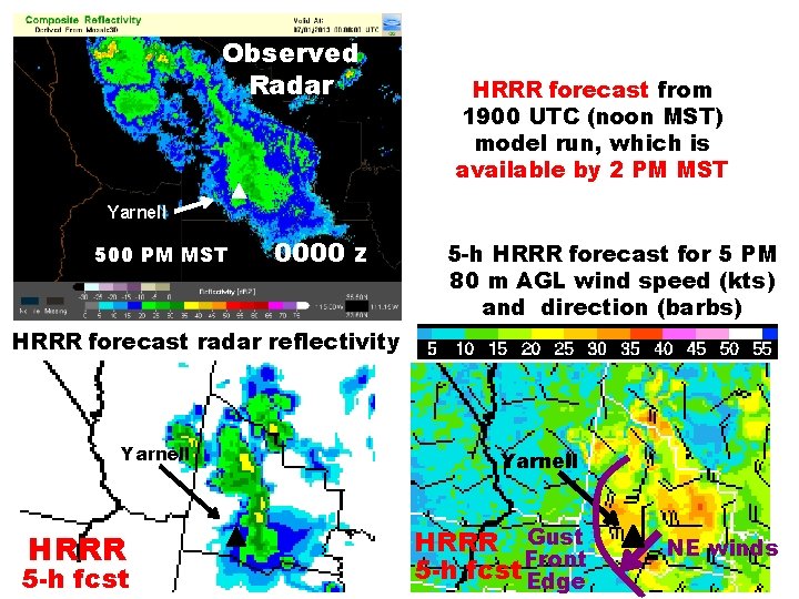
Yarnell, AZ Wildfire Background Wildfire Driven by thunderstorm outflow , 30 June 2013 July 2, 2013 Yarnell, AZ Wildfire Perimeter Radar Reflectivity 4 PM MST June 30, 2013 Yarnell, AZ Last contact with fire crew ~ 4: 30 PM MST (2330 UTC) Sun. 30 June, 2013
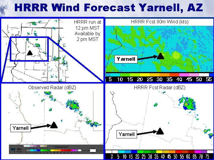
HRRR Forecast HRRR Wind (and HRRR RAP) Milestones Future Yarnell, Milestones. AZ HRRR run at 12 pm MST Available by 2 pm MST HRRR Fcst 80 m Wind (kts) Yarnell Observed Radar (d. BZ) HRRR Fcst Radar (d. BZ) Yarnell
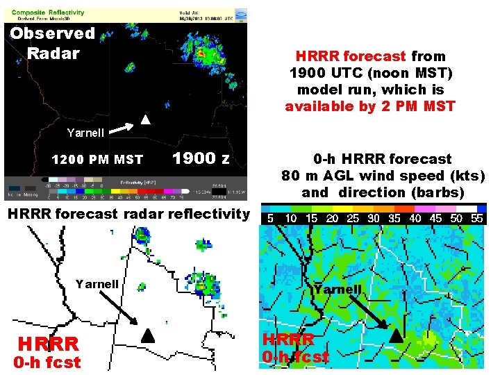
Observed Radar HRRR forecast from 1900 UTC (noon MST) model run, which is available by 2 PM MST Yarnell 1200 PM MST 1900 z 0 -h HRRR forecast 80 m AGL wind speed (kts) and direction (barbs) HRRR forecast radar reflectivity Yarnell HRRR 0 -h fcst
Observed Radar HRRR forecast from 1900 UTC (noon MST) model run, which is available by 2 PM MST Yarnell 100 PM MST 2000 z 1 -h HRRR forecast for 1 PM 80 m AGL wind speed (kts) and direction (barbs) HRRR forecast radar reflectivity Yarnell HRRR 1 -h fcst
Observed Radar HRRR forecast from 1900 UTC (noon MST) model run, which is available by 2 PM MST Yarnell 200 PM MST 2100 z 2 -h HRRR forecast for 2 PM 80 m AGL wind speed (kts) and direction (barbs) HRRR forecast radar reflectivity Yarnell HRRR 2 -h fcst Gust Front Edge
HRRR forecast from 1900 UTC (noon MST) model run, which is available by 2 PM MST Observed Radar Yarnell 300 PM MST 2200 z 3 -h HRRR forecast for 3 PM 80 m AGL wind speed (kts) and direction (barbs) HRRR forecast radar reflectivity Yarnell HRRR 3 -h fcst Gust Front Yarnell Edge HRRR 3 -h fcst SW winds
HRRR forecast from 1900 UTC (noon MST) model run, which is available by 2 PM MST Observed Radar Yarnell 400 PM MST 2300 z 4 -h HRRR forecast for 4 PM 80 m AGL wind speed (kts) and direction (barbs) HRRR forecast radar reflectivity Yarnell HRRR 4 -h fcst Gust Front Edge
Observed Radar HRRR forecast from 1900 UTC (noon MST) model run, which is available by 2 PM MST Yarnell 500 PM MST 0000 z 5 -h HRRR forecast for 5 PM 80 m AGL wind speed (kts) and direction (barbs) HRRR forecast radar reflectivity Yarnell HRRR 5 -h fcst Yarnell HRRR Gust 5 -h fcst. Front Edge NE winds
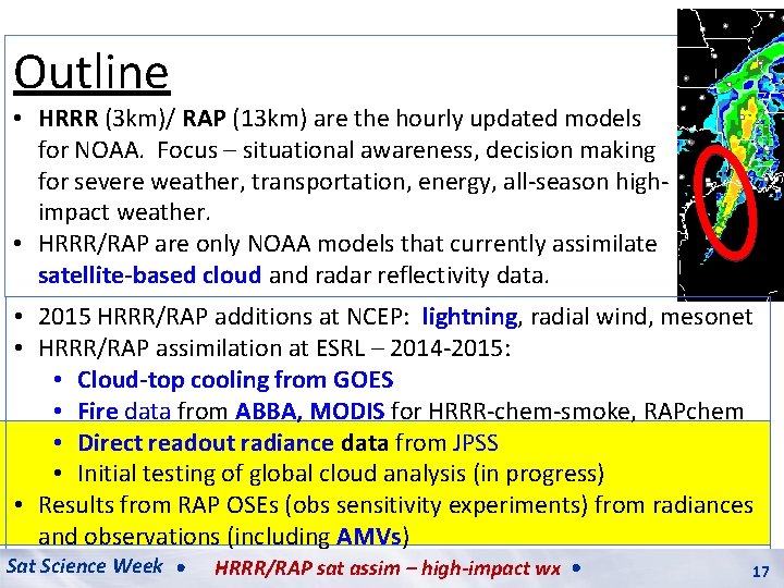
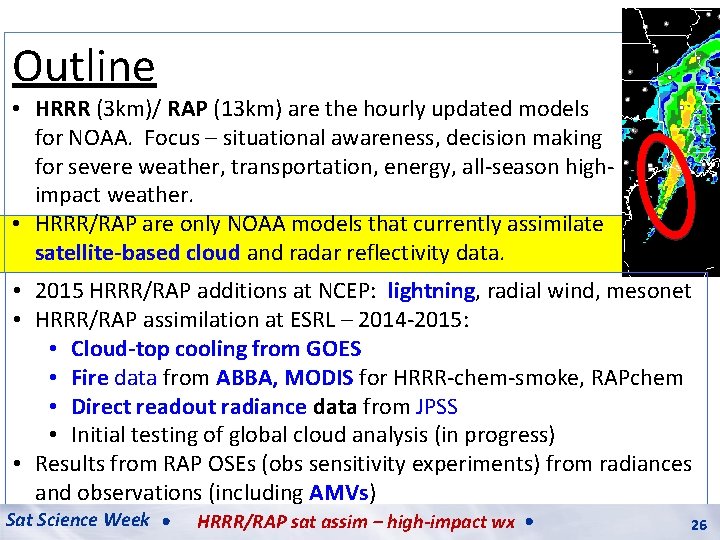
Outline • HRRR (3 km)/ RAP (13 km) are the hourly updated models for NOAA. Focus – situational awareness, decision making for severe weather, transportation, energy, all-season highimpact weather. • HRRR/RAP are only NOAA models that currently assimilate satellite-based cloud and radar reflectivity data. • 2015 HRRR/RAP additions at NCEP: lightning, radial wind, mesonet • HRRR/RAP assimilation at ESRL – 2014 -2015: • Cloud-top cooling from GOES • Fire data from ABBA, MODIS for HRRR-chem-smoke, RAPchem • Direct readout radiance data from JPSS • Initial testing of global cloud analysis (in progress) • Results from RAP OSEs (obs sensitivity experiments) from radiances and observations (including AMVs) Sat Science Week HRRR/RAP sat assim – high-impact wx 17 17
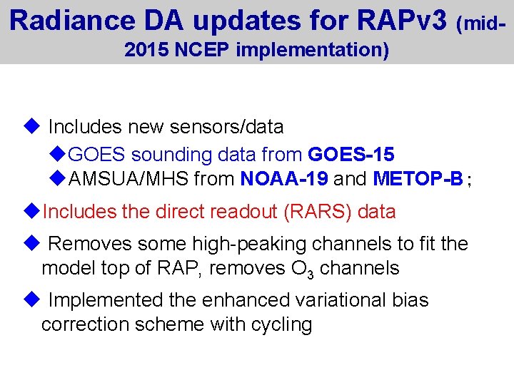
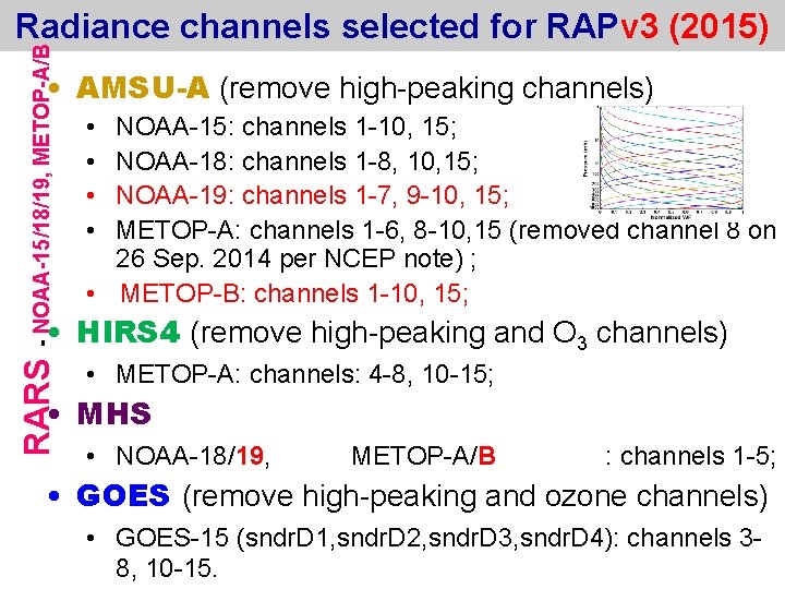
Radiance DA updates for RAPv 3 (mid 2015 NCEP implementation) u Includes new sensors/data u. GOES sounding data from GOES-15 u. AMSUA/MHS from NOAA-19 and METOP-B; u. Includes the direct readout (RARS) data u Removes some high-peaking channels to fit the model top of RAP, removes O 3 channels u Implemented the enhanced variational bias correction scheme with cycling
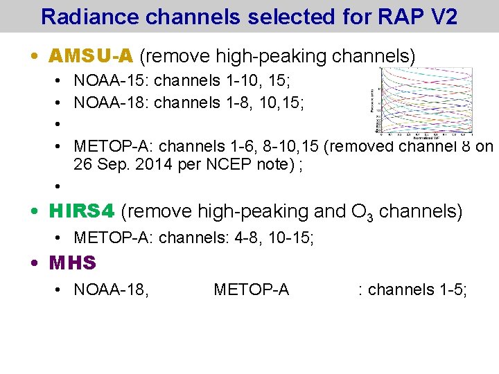
Radiance channels selected for RAP V 2 • AMSU-A (remove high-peaking channels) • NOAA-15: channels 1 -10, 15; • NOAA-18: channels 1 -8, 10, 15; • • METOP-A: channels 1 -6, 8 -10, 15 (removed channel 8 on 26 Sep. 2014 per NCEP note) ; • • HIRS 4 (remove high-peaking and O 3 channels) • METOP-A: channels: 4 -8, 10 -15; • MHS • NOAA-18, METOP-A : channels 1 -5;
RARS - NOAA-15/18/19, METOP-A/B Radiance channels selected for RAPv 3 (2015) • AMSU-A (remove high-peaking channels) • • NOAA-15: channels 1 -10, 15; NOAA-18: channels 1 -8, 10, 15; NOAA-19: channels 1 -7, 9 -10, 15; METOP-A: channels 1 -6, 8 -10, 15 (removed channel 8 on 26 Sep. 2014 per NCEP note) ; • METOP-B: channels 1 -10, 15; • HIRS 4 (remove high-peaking and O 3 channels) • METOP-A: channels: 4 -8, 10 -15; • MHS • NOAA-18/19, METOP-A/B : channels 1 -5; • GOES (remove high-peaking and ozone channels) • GOES-15 (sndr. D 1, sndr. D 2, sndr. D 3, sndr. D 4): channels 38, 10 -15.
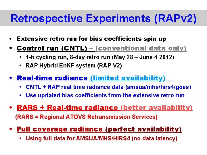
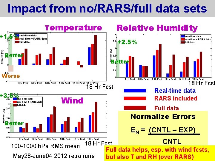
Retrospective Experiments (RAPv 2) • Extensive retro run for bias coefficients spin up • Control run (CNTL) – (conventional data only) • 1 -h cycling run, 8 -day retro run (May 28 – June 4 2012) • RAP Hybrid En. KF system (RAP V 2) • Real-time radiance (limited availability) • CNTL + RAP real time radiance data (amsua/mhs/hirs 4/goes) • Use updated bias coefficients from the extensive retro run • RARS + Real-time radiance (better availability) (RARS = Regional ATOVS Retransmission Services) • Full coverage radiance (perfect availability) • Using full data for AMSUA/MHS/HIRS 4 (no data latency)
Impact from no/RARS/full data sets +1. 5% Temperature Relative Humidity +2. 5% Better Worse 18 Hr Fcst +3. 5% Better Wind 18 Hr Fcst Real-time data RARS included Full data Normalize Errors EN = (CNTL – EXP) CNTL 18 Hr Fcst 100 -1000 h. Pa RMS mean Full data helps, esp. with wind fcsts, May 28 -June 04 2012 retro runs but also T and RH (over RARS)
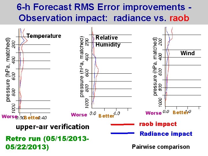
6 -h Forecast RMS Error improvements Observation impact: radiance vs. raob Temperature Relative Humidity Wind Worse Better Worse upper-air verification Retro run (05/15/201305/22/2013) Better Worse Better raob impact Radiance impact Pairwise comparison
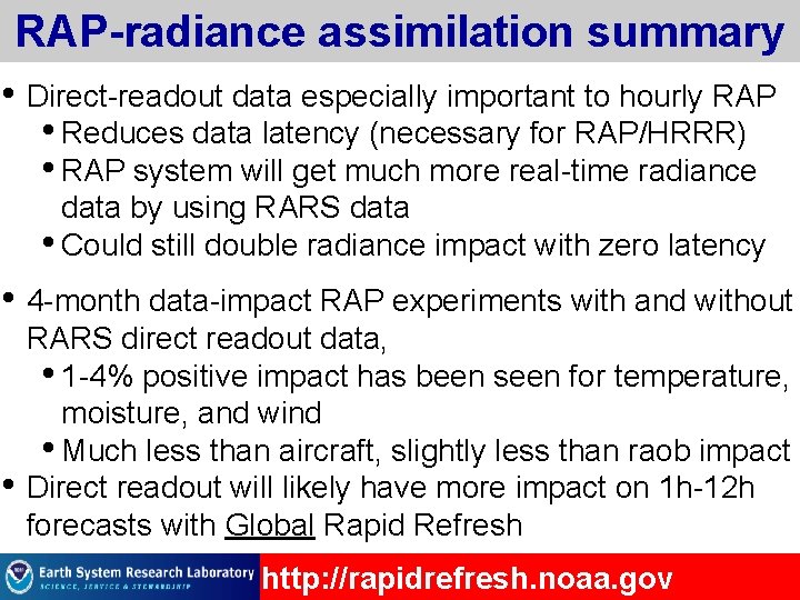
RAP-radiance assimilation summary • Direct-readout data especially important to hourly RAP • Reduces data latency (necessary for RAP/HRRR) • RAP system will get much more real-time radiance data by using RARS data • Could still double radiance impact with zero latency • 4 -month data-impact RAP experiments with and without • RARS direct readout data, • 1 -4% positive impact has been seen for temperature, moisture, and wind • Much less than aircraft, slightly less than raob impact Direct readout will likely have more impact on 1 h-12 h forecasts with Global Rapid Refresh http: //rapidrefresh. noaa. gov
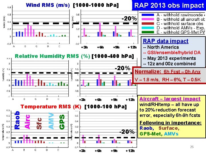
Wind RMS (m/s) [1000 -1000 h. Pa] RAP 2013 obs impact -20% RAP data impact +3 h +6 h +9 h +12 h Relative Humidity RMS (%) [1000 -400 h. Pa] -20% -- North America -- GSI/ensemble/hybrid DA -- May 2013 experiments -- 12 z and 00 z combined Normalize: 6 h Fcst – 0 h Anx V – 1. 8 m/s, RH – 6%, T – 0. 5 K +3 h +6 h +9 h +12 h GPS AMV Sfc Raob Airc Temperature RMS (K) [1000 -100 h. Pa] -20% +3 h +6 h +9 h +12 h Aircraft – largest impact wind/RH/temp – all have up to 20% reduction forecast error, especially 6 h-9 h fcsts Following in importance: Raob, Surface, GPS-Met, AMVs 25
Outline • HRRR (3 km)/ RAP (13 km) are the hourly updated models for NOAA. Focus – situational awareness, decision making for severe weather, transportation, energy, all-season highimpact weather. • HRRR/RAP are only NOAA models that currently assimilate satellite-based cloud and radar reflectivity data. • 2015 HRRR/RAP additions at NCEP: lightning, radial wind, mesonet • HRRR/RAP assimilation at ESRL – 2014 -2015: • Cloud-top cooling from GOES • Fire data from ABBA, MODIS for HRRR-chem-smoke, RAPchem • Direct readout radiance data from JPSS • Initial testing of global cloud analysis (in progress) • Results from RAP OSEs (obs sensitivity experiments) from radiances and observations (including AMVs) Sat Science Week HRRR/RAP sat assim – high-impact wx 26 26
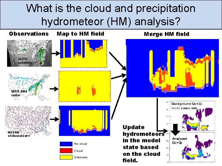
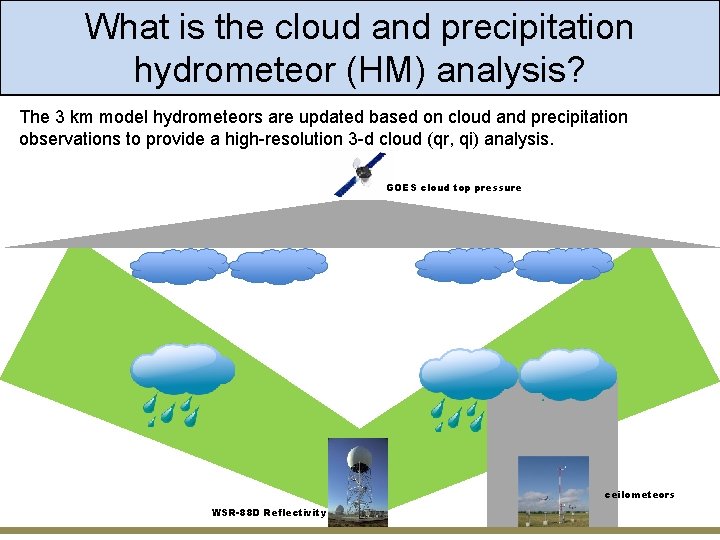
What is the cloud and precipitation hydrometeor (HM) analysis? Observations Map to HM field ceilometeors No cloud Cloud Unknown Merge HM field Update hydrometeors in the model state based on the cloud field.
What is the cloud and precipitation hydrometeor (HM) analysis? The 3 km model hydrometeors are updated based on cloud and precipitation observations to provide a high-resolution 3 -d cloud (qr, qi) analysis. GOES cloud top pressure ceilometeors WSR-88 D Reflectivity
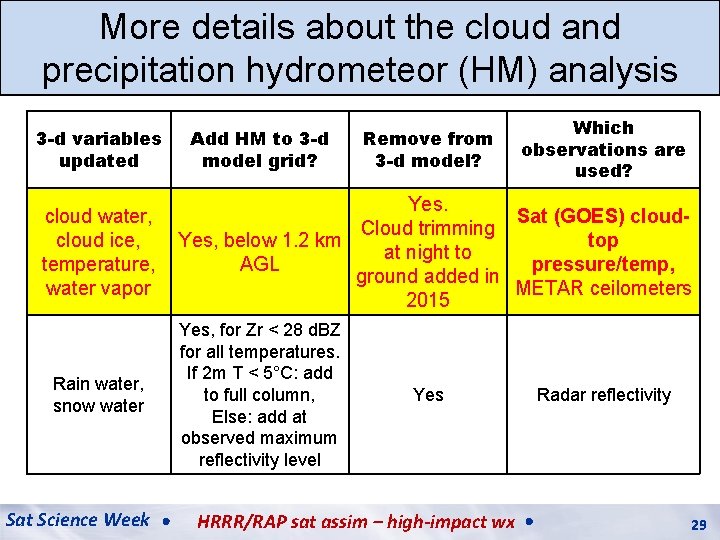
More details about the cloud and precipitation hydrometeor (HM) analysis 3 -d variables updated cloud water, cloud ice, temperature, water vapor Rain water, snow water Sat Science Week Add HM to 3 -d model grid? Remove from 3 -d model? Which observations are used? Yes. Sat (GOES) cloud. Cloud trimming Yes, below 1. 2 km top at night to AGL pressure/temp, ground added in METAR ceilometers 2015 Yes, for Zr < 28 d. BZ for all temperatures. If 2 m T < 5°C: add to full column, Else: add at observed maximum reflectivity level Yes HRRR/RAP sat assim – high-impact wx Radar reflectivity 29
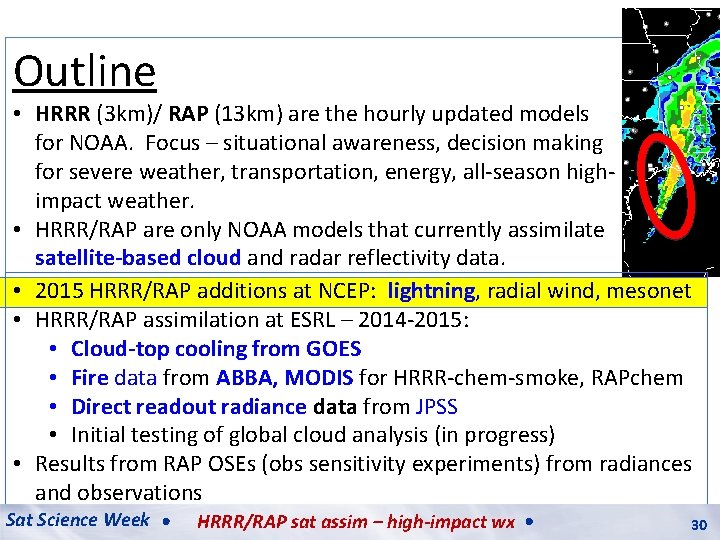
Outline • HRRR (3 km)/ RAP (13 km) are the hourly updated models for NOAA. Focus – situational awareness, decision making for severe weather, transportation, energy, all-season highimpact weather. • HRRR/RAP are only NOAA models that currently assimilate satellite-based cloud and radar reflectivity data. • 2015 HRRR/RAP additions at NCEP: lightning, radial wind, mesonet • HRRR/RAP assimilation at ESRL – 2014 -2015: • Cloud-top cooling from GOES • Fire data from ABBA, MODIS for HRRR-chem-smoke, RAPchem • Direct readout radiance data from JPSS • Initial testing of global cloud analysis (in progress) • Results from RAP OSEs (obs sensitivity experiments) from radiances and observations Sat Science Week HRRR/RAP sat assim – high-impact wx 30 30
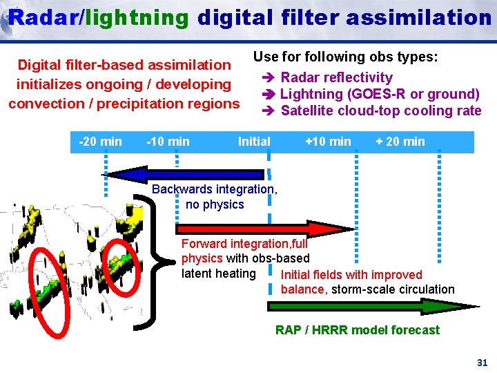
Radar/lightning digital filter assimilation HRRR (and HRRR RAP) Milestones Future Milestones Reflectivity Digital filter-based assimilation initializes ongoing / developing convection / precipitation regions -20 min -10 min Use for following obs types: Radar reflectivity Lightning (GOES-R or ground) Satellite cloud-top cooling rate Initial +10 min + 20 min Backwards integration, no physics Forward integration, full physics with obs-based latent heating Initial fields with improved balance, storm-scale circulation RAP / HRRR model forecast 31
Outline • HRRR (3 km)/ RAP (13 km) are the hourly updated models for NOAA. Focus – situational awareness, decision making for severe weather, transportation, energy, all-season highimpact weather. • HRRR/RAP are only NOAA models that currently assimilate satellite-based cloud and radar reflectivity data. • 2015 HRRR/RAP additions at NCEP: lightning, radial wind, mesonet • HRRR/RAP assimilation at ESRL – 2014 -2015: • Cloud-top cooling from GOES • Fire data from ABBA, MODIS for HRRR-chem-smoke, RAPchem • Direct readout radiance data from JPSS • Initial testing of global cloud analysis (in progress) • Results from RAP OSEs (obs sensitivity experiments) from radiances and observations 32
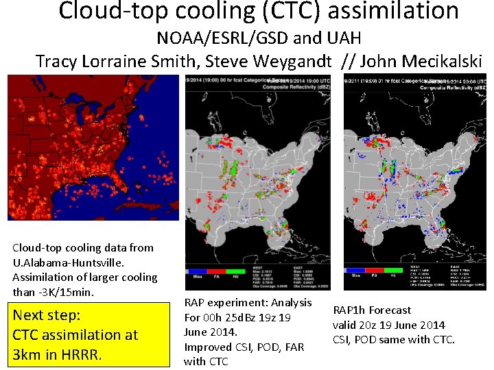
Cloud-top cooling (CTC) assimilation NOAA/ESRL/GSD and UAH Tracy Lorraine Smith, Steve Weygandt // John Mecikalski Cloud-top cooling data from U. Alabama-Huntsville. Assimilation of larger cooling than -3 K/15 min. Next step: CTC assimilation at 3 km in HRRR. RAP experiment: Analysis For 00 h 25 d. Bz 19 June 2014. Improved CSI, POD, FAR with CTC RAP 1 h Forecast valid 20 z 19 June 2014 CSI, POD same with CTC.
Outline • HRRR (3 km)/ RAP (13 km) are the hourly updated models for NOAA. Focus – situational awareness, decision making for severe weather, transportation, energy, all-season highimpact weather. • HRRR/RAP are only NOAA models that currently assimilate satellite-based cloud and radar reflectivity data. • 2015 HRRR/RAP additions at NCEP: lightning, radial wind, mesonet • HRRR/RAP assimilation at ESRL – 2014 -2015: • Cloud-top cooling from GOES • Fire data from ABBA, MODIS for HRRR-chem-smoke, RAPchem • Direct readout radiance data from JPSS • Initial testing of global cloud analysis (in progress) • Results from RAP OSEs (obs sensitivity experiments) from radiances and observations Sat Science Week HRRR/RAP sat assim – high-impact wx 34 34
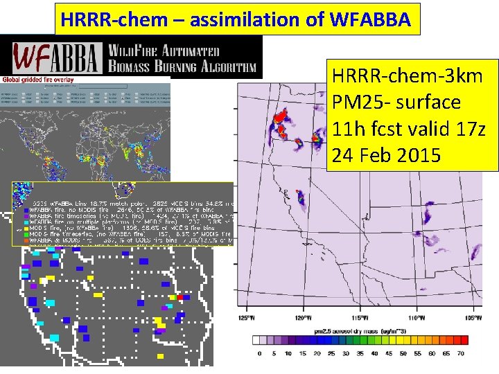
HRRR-chem – assimilation of WFABBA HRRR-chem-3 km PM 25 - surface 11 h fcst valid 17 z 24 Feb 2015 35
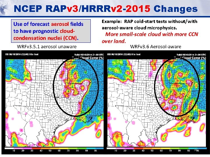
NCEP RAPv 3/HRRRv 2 -2015 Changes Use of forecast aerosol fields to have prognostic cloudcondensation nuclei (CCN). Example: RAP cold-start tests without/with aerosol-aware cloud microphysics. More small-scale cloud with more CCN over land. 36
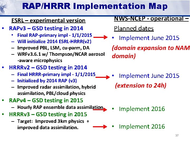
RAP/HRRR Implementation Map HRRR (and HRRR RAP) Milestones Future Milestones ESRL – experimental version • RAPv 3 – GSD testing in 2014 • – – – Final RAP-primary impl - 1/1/2015 Will initialize 2014 ESRL-HRRR(v 2) Improved PBL, LSM, cu-parm, DA WRFv 3. 6. 1 w/ Thompson/NCAR aerosol -aware microphysics NWS-NCEP - operational – Planned dates • Implement June 2015 (domain expansion to NAM domain) • HRRRv 2 – GSD testing in 2014 – Final HRRR-primary impl - 1/1/2015 – Initialized by 2014 RAP (v 3) – Improved radar assimilation, hybrid assimilation, PBL/cloud physics • Implement June 2015 (extension to 24 h) – Hourly RAP ensemble data assimilation • Implement 2016 – Target: Improved 3 km physics + improved data assimilation. • Implement 2016 • RAPv 4 – GSD testing in 2015 • HRRRv 3 – GSD testing in 2015 37
Improved high-impact weather HRRR/RAP forecast accuracy from assimilation of satellite-based cloud, lightning, convection, AMVs, fire, and radiance data • HRRR (3 km)/ RAP (13 km) are the hourly updated models for NOAA. Rapid Refresh Focus – situational awareness, decision making for severe weather, reflectivity - 0 h valid 02 z 26 Jan 2012 transportation, energy, all-season high-impact weather. • HRRR/RAP are only NOAA models that currently assimilate satellite. With based cloud and radar reflectivity data. • 2015 HRRR/RAP additions at NCEP: lightning, radial wind, mesonet lightning • HRRR/RAP assimilation at ESRL – 2014 -2015: assim • Cloud-top cooling from GOES • Fire data from ABBA, MODIS for HRRR-chem-smoke, RAPchem No • Direct readout radiance data from JPSS • Initial testing of global cloud analysis (in progress) lightning assim • 2015 -17 – storm-scale ens assimilation – GSI – 4 d. En. Var • HRRR ensemble, toward 15 -min update cycle (5 min) • Satellite data – GOES-R+, JPSS/SNPP – critical to improve HRRR as primary short-range prediction of high-impact wx
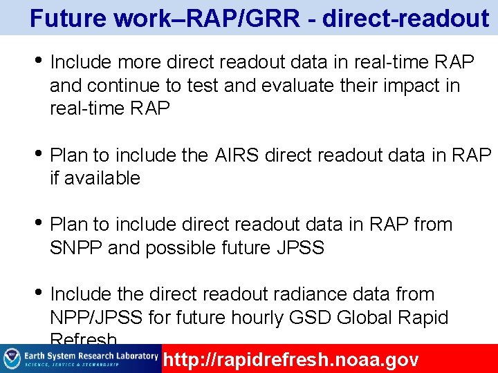
Future work–RAP/GRR - direct-readout • Include more direct readout data in real-time RAP and continue to test and evaluate their impact in real-time RAP • Plan to include the AIRS direct readout data in RAP if available • Plan to include direct readout data in RAP from SNPP and possible future JPSS • Include the direct readout radiance data from NPP/JPSS for future hourly GSD Global Rapid Refresh http: //rapidrefresh. noaa. gov