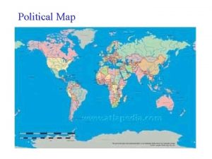
Political Geography Political map 1 CE Political Map


- Slides: 34

Political Geography

Political map 1 CE

Political Map 500 CE

Political Map 1400

Political Map 1700

• Prior to 1800 much of the worlds surface historically consisted of unorganized territory • Imperialism greatly changed this in 2 waves • 1 st wave 1600 s • 2 nd wave late 1800 s

1900

Cold War Era 1945 – 1991 (174 countries)

1995 • https: //www. youtube. com/watch? v=5 p. OFKmk 7 yt. U

2016 – (195 countries)

• Nation: • geographic area that is dominated by a large population that shares a common history and culture

STATE • A politically organized territory • Administered by a sovereign government • Recognized by a significant portion of the international community. A state must also contain: • a permanent resident population • an organized economy

Nation-State • political unit comprising a clearly delineated territory where the population shares a common history and culture, • Example - Japan.

Boundaries are: • Lines that establish the limit of each jurisdiction & authority • Jurisdiction administers laws; collects taxes; provides defense, education, training; enforces legal code, etc. • 3 -dimensional: flat, deep, high

Political Boundaries • Political boundaries represent the spatial limit of the political organization of territory • They exist at different scales: • Supra-national-scale organizations, international organizations such as UN • State-scale - Countries • Intra-state scale; boundaries used for the many subdivisions of territory within the state, such as…?

Boundary Types • Physical Boundary: major physical features such as a desert, mountain ranges, and/or water bodies that serves as a means of separation, • ie. Great Lakes, Pyrenees Mountains, and Sahara desert.

Boundary Types • Geometric Boundary: straight lines that serve as political boundaries that are unrelated to physical and /or cultural differences, ie. 1300 mile (straight line) United States/Canadian border.

How the States Got their Shapes? Ep 1 start

Boundary Types • Cultural Political Boundary: political boundary that separates different cultures, • ie. former Yugoslavia.

Boundary Types • Religious Boundary: boundary that separates different religions, • ie. Northern Ireland (protestant)/Ireland (Catholic).

Boundary Types • Language Boundary: boundary that separates different language speakers, • ie. traditionally many countries in Europe such as England, France, Spain, and Portugal.

• Super Imposed Boundary: • a boundary imposed on the territory of one nation that divides the members of the nation into two different states. Such boundaries are always unstable. • North & South Vietnam • North & South Korea • MOST OF AFRICA! Boundary Types

Superimposed Boundaries

The Scramble for Africa • The focus of most of Europe’s imperialist activities in the 19 th century was Africa. • https: //www. youtube. com/watch? v=Pis 5 f 085 P 3 M

• Until 1880’s only the coastlines of Africa had been colonized or explored • Gold, ivory and slaves had been taken from these colonies • The slave trade ended in the 1800’s but European powers now had control of most of the African coast The Scramble for Africa

Internal Reasons for Imperialism • African nations lacked unity • No common language • Lack of common culture • Wars between different groups • Lack of technology • Guns germs steel

• Rules for the Colonization of Africa • In 1884 European powers trying to colonize Africa were coming into conflict. • To avoid further conflict 14 European powers set up rules for colonizing Africa. • No members of the African community were present. The Berlin Conference

• Results of the Conference • In 1850 most of Africa had been free. • By 1914 only Liberia and Ethiopia were free of European control.

• Fortified Boundary: when a state constructs physical barriers along a boundary to either keep people in or out of their territory, • ie. Great Wall of China, Berlin Wall, • https: //www. youtube. com/watc h? v=Yl. SFs 9 Oen 3 A • US debating over creating one Boundary Types

Buffer Zone/Buffer State • a neutral area serving to separate hostile forces or nations broadly • a small neutral country, situated between two larger hostile countries, serving to prevent the outbreak of regional conflict. • Ex. Countries aligned with USSR in Europe during Cold War • Ex. Mongolia, North Korea

Supranational Division or International Cooperation • Multi-national treaties and trade blocks – either economic or military • Example • NATO – military • EU - Economic

Shapes of States • Compact State: • the distance from the geographic center of the area to any point on the boundary does not vary greatly, • ie. Hungary.

Shapes of States • Elongated State: • state that is geographically long and narrow, • ie. Chile.

Shapes of States • Landlocked State: state not having direct access to an ocean, ie. Bolivia. • Problems that landlocked states face?
 Ap human geography frqs
 Ap human geography political geography test
 Map of europe in 1990
 5 themes of geography ap human geography
 Classification of boundaries in political geography
 Objectives of political geography
 Population density map australia
 Relationship between political science and geography
 Boundaries ap human geography
 Compare geometric boundaries and antecedent boundaries.
 Political geography
 Centripetal vs centrifugal
 Topographic map definition ap human geography
 Mental map ap human geography
 Geography map rubric
 Types of map projections ap human geography
 Greece map mountains
 Zoning definition ap human geography
 Proportional symbol map ap human geography
 Remote sensing ap human
 Geography in ancient greece
 Weather station geography
 Mezzogiorno map leaving cert
 Mr stepek ap human geo
 Dot density map definition ap human geography
 Types of map scales in geography
 The first successful english colony was
 Generalized map ap human geography
 The study of human and nonhuman features of earth
 Alps mountains map
 Geographical coordinate system
 Metes and bounds ap human geography
 Geography synoptic weather map
 Swana map
 Swana
Swana

