Geography and Map Skills Unit Objective By the

Geography and Map Skills Unit Objective By the end of this lesson, I will be able to Use latitude and longitude to determine direction or locate or compare points on a map or representation of a globe. (G-1 A-M 2) • Today’s Objective: • By the end of class today, I will be able to identify and use the various tools to measure and divide the earth in an activote exit quiz with at least 85% accuracy • Agenda: • Bell Ringer: Copy objective and answer the following question • What are the different ways that we tell people where something is? • New Learning: geography key terms • Check for understanding quiz (5 Questions)

Mapping the Earth NOTES • The globe Is a scale representation of the earth • Divided by a grid, which is a web of intersecting lines that allow us to find places on the earth • Lines that run North-South and measure degrees east and west of the Prime Meridian (0⁰) are called longitude (also called meridians because they run the same direction as the Prime Meridian) • Lines that run east - west and measure degrees North-South of the Equator (0⁰) are called latitude (also called parallels because they run parallel to the equator)

Lines of Latitude • Range from 0⁰ at the equator to 90⁰ North or South at the Poles • Parallels above the Equator are ⁰N, and parallels below the equator are ⁰S

Lines of Longitude • Range from 0 ⁰ on the Primer Meridian to 180⁰ East or West to the mid-Pacific Ocean • Meridians that measure east of the prime meridian are ⁰E, Meridians that are West of the prime Meridian are ⁰W

Hemispheres • The equator and the Prime Meridian divide the world into 4 Hemispheres • • North South East West Any place can be in 2 hemispheres at one time v Northeast v Northwest v Southeast v Southwest

Earth’s Water • Geographers categorize earth’s water surface into parts • Largest is the world ocean. Divided into 4 parts: • • Indian Arctic Atlantic Pacific • Lakes and seas are smaller bodies of water

Landmasses • The globe has 7 large landmasses called continents • • Australia Africa Asia Europe North America South America Antarctica • Landmasses smaller than continents but surrounded completely by water are called islands

Exit Quiz: 1. North – South lines are called A. B. C. D. Degrees Longitude Latitude Continents

2. East- west lines are called A. B. C. D. Degrees Longitude Latitude Continents

• Our planet is divided into 7 large landmasses called A. B. C. D. Islands Meridians Continents Parallels
___ hemispheres A. B. C.")
• Our globe can be divided in to _(#)___ hemispheres A. B. C. D. 2 6 8 4

• The largest body of water is the Ocean, and Geographers divide it into 4 parts. Which is NOT an ocean? A. B. C. D. Atlantic Mediterranean Artic Indian

Geography and Map Skills Unit Objective By the end of this lesson, I will be able to Use latitude and longitude to determine direction or locate or compare points on a map or representation of a globe. (G-1 A-M 2) O Today’s Objective: O By the end of class today I will be able to recognize and recreate the various types of map projections from memory in an exit ticket out with at least 80% accuracy O Agenda: O Bell Ringer: Copy objective and answer the following question O What are the different ways that we tell people where something is? O New Learning: map projections O I do: Model how to recognize the various types of map projections O You do: exit quiz recreate map projections

Mapmaking O A map is a flat diagram of all or part of the earth’s surface O Mapmakers have created a variety of projections to show our round planet on flat maps O Because the earth is round, all flat maps are slightly distorted

Cylindrical projection O Based on a cylinder wrapped around the globe O The cylinder only touches the globe at the equator O Meridians are pulled apart rather than meeting at the poles O One type is a Mercator projection O Good for navigation but distorts the size of landmasses, especially close to the poles

Conic Projection O Based on a cone placed over the globe O Most accurate for longitude and latitude where the cone touches the globe; land masses are almost true shape and size O Good for use with areas with large east-west distances, like the United States

Flat-Plane Projection O Based on a plane touching the globe at one point, like one of the poles O Useful for true direction for airplane pilots and ship navigators O Shows true area but distorts landmass shape

I Do: Think aloud: What type of map projection O What kind of map projection is this? Defend your answer? O I see that the meridians, lines of longitude, are meeting at the center of this map. I can only see to around the Equator. This tells me that I am looking at either the North or the South Pole. Using my prior knowledge of the continents, I know that I am looking at the North pole. This is a Flat plane map.

We Do: With your partner, Identify these types of maps

You do/Exit Ticket: O Draw each of the 3 map projections from memory and label them to the best of your ability with at least 80% accuracy

Geography and Map Skills Unit Objective By the end of this lesson, I will be able to Use latitude and longitude to determine direction or locate or compare points on a map or representation of a globe. (G-1 A-M 2) O Today’s Objective: O By the end of class today I will be able to use longitude and latitude to find places on a map in an exit ticket out with at least 80% accuracy O Agenda: O Bell Ringer: Copy objective and answer the following question O How could longitude and latitude help people of different countries to find places easier? O New Learning: Map Essentials and Using longitude and latitude O I do: model finding a place using longitude and latitude O We do: rally coach each find 3 locations O You do: 10 question longitude and latitude quiz

Map Essentials O Title – tells the subject O O of the map Compass rose – the direction the map is facing Scale – represents distances between points Legend – explains symbols or colors on the map Locator map- shows where in the world the particular map is located

I Do: Watch and Listen http: //www. purposegames. com/game/longitude-andlatitude-quiz

Working with Maps • By the end of class today, I will be able to interpret the various types of maps by studying the titles and map keys in an Exit ticket out with 85% accuacy O Agenda: O Bell Ringer: Copy objective and answer the following question O What are different ways that maps can be used? O New Learning: Working with Maps O I do: model how to approach a map an determine its purpose O We do: rally robin identify the purpose of 4 maps O You do/Exit ticket: Create any of the maps that we discussed today. Label it and explain what characteristics are present that make it that map.

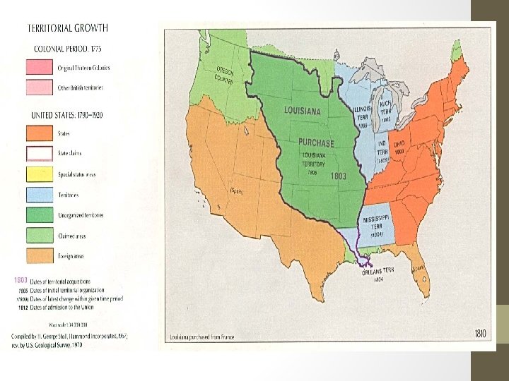
Historical Maps • Maps that show information about the past • Lands an empire controlled • Where certain groups of people lives • How a place changed over time • Colors used to indicate different things on a map

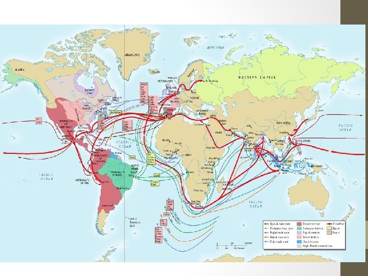
Route map • Shows the route, path that someone or something followed • Can show trade routes, invasion routes, or the journeys and travels of people • Routes shown with an arrow • If many routes they will have several arrows with different colors

Climate map • Shows climate patterns for different regions

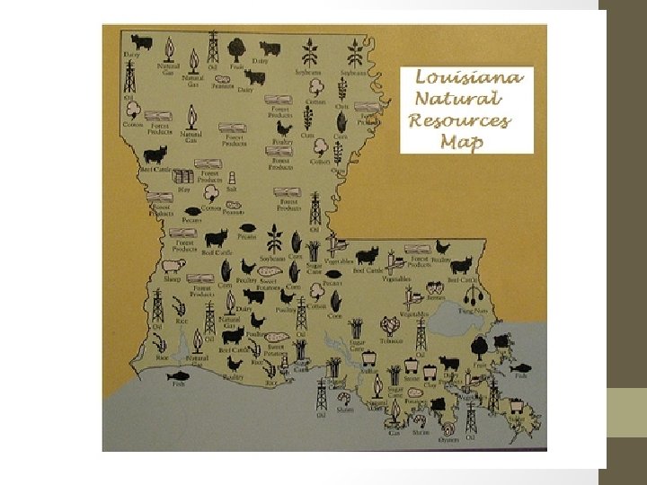
Resource Map • resource map shows the specific type of economic activity or natural resources present in an area through the use of different symbols or colors

I DO: Type of Map?

We Do? Name that Map Rally Table

You Do/ Exit Ticket • Create any of the maps that we discussed today. Label it and explain what characteristics are present that make it that map.
- Slides: 34