NRL Monterey Plans for Tropical Cyclone Modeling using

- Slides: 38

NRL Monterey Plans for Tropical Cyclone Modeling using the Coupled Ocean/Atmosphere Mesoscale Prediction System (COAMPS) 61 st Interdepartmental Hurricane Conference, New Orleans, LA 6 March 2007 Richard M. Hodur Marine Meteorology Division Naval Research Laboratory Monterey, CA COAMPS® is a registered trademark of the Naval Research Laboratory

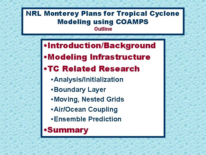
NRL Monterey Plans for Tropical Cyclone Modeling using COAMPS Outline • Introduction/Background • Modeling Infrastructure • TC Related Research • Analysis/Initialization • Boundary Layer • Moving, Nested Grids • Air/Ocean Coupling • Ensemble Prediction • Summary

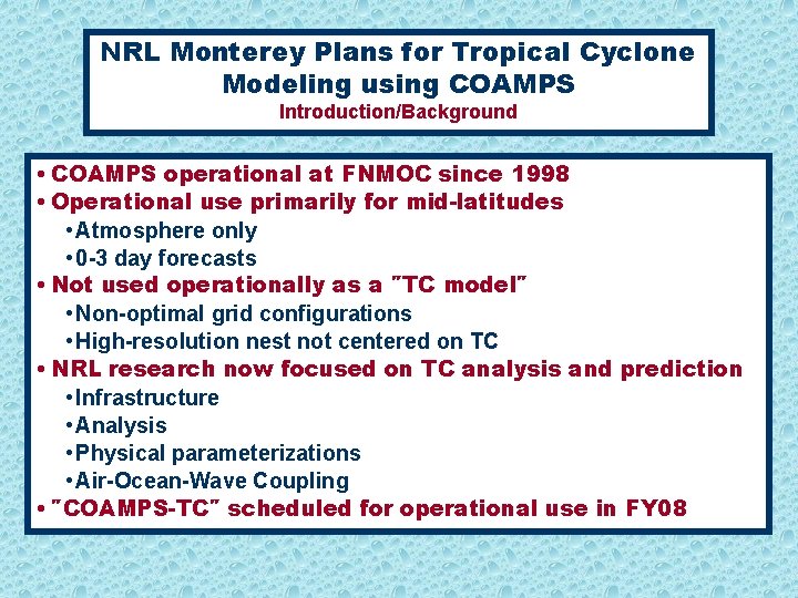
NRL Monterey Plans for Tropical Cyclone Modeling using COAMPS Introduction/Background • COAMPS operational at FNMOC since 1998 • Operational use primarily for mid-latitudes • Atmosphere only • 0 -3 day forecasts • Not used operationally as a ″TC model″ • Non-optimal grid configurations • High-resolution nest not centered on TC • NRL research now focused on TC analysis and prediction • Infrastructure • Analysis • Physical parameterizations • Air-Ocean-Wave Coupling • ″COAMPS-TC″ scheduled for operational use in FY 08

NRL Monterey Plans for Tropical Cyclone Modeling using COAMPS Outline • Introduction/Background • Modeling Infrastructure • TC Related Research • Analysis/Initialization • Boundary Layer • Moving, Nested Grids • Air/Ocean Coupling • Ensemble Prediction • Summary

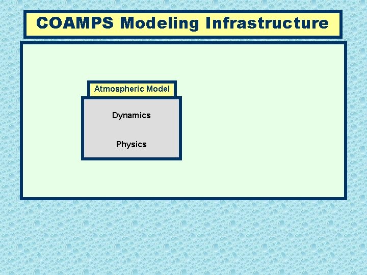
COAMPS Modeling Infrastructure Atmospheric Model Dynamics Physics

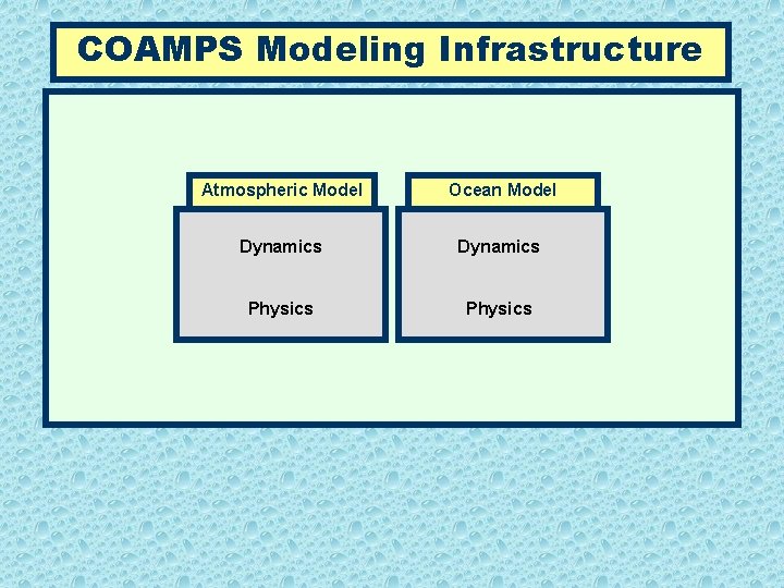
COAMPS Modeling Infrastructure Atmospheric Model Ocean Model Dynamics Physics

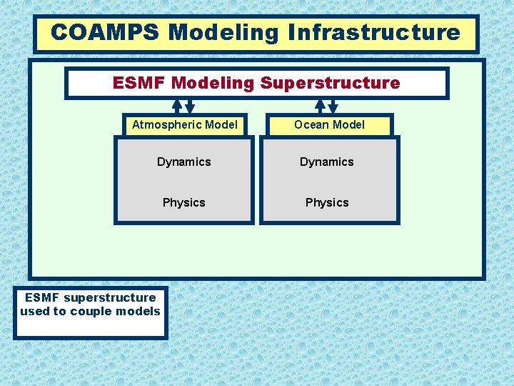
COAMPS Modeling Infrastructure ESMF Modeling Superstructure Atmospheric Model Ocean Model Dynamics Physics ESMF superstructure used to couple models

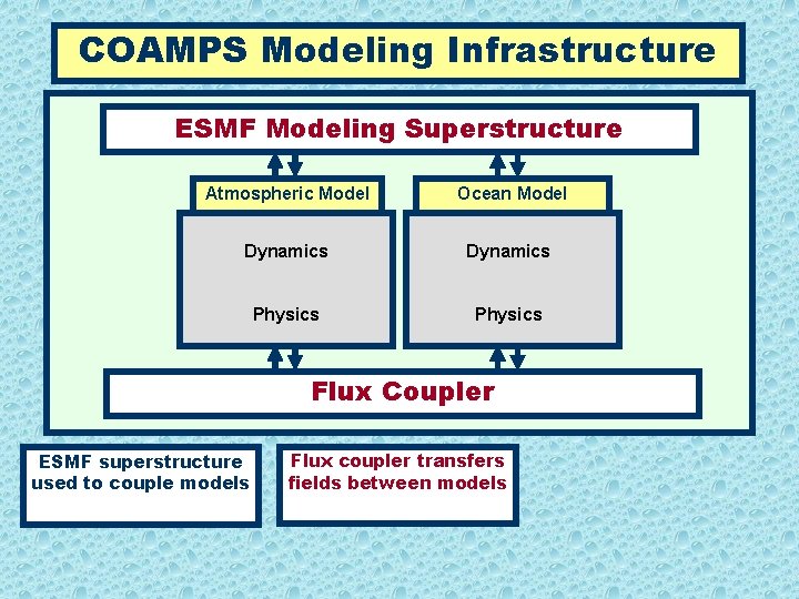
COAMPS Modeling Infrastructure ESMF Modeling Superstructure Atmospheric Model Ocean Model Dynamics Physics Flux Coupler ESMF superstructure used to couple models Flux coupler transfers fields between models

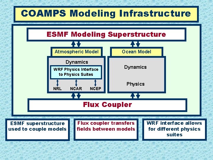
COAMPS Modeling Infrastructure ESMF Modeling Superstructure Atmospheric Model Dynamics WRF Physics Interface to Physics Suites NRL NCAR NCEP Ocean Model Dynamics Physics Flux Coupler ESMF superstructure used to couple models Flux coupler transfers fields between models WRF interface allows for different physics suites

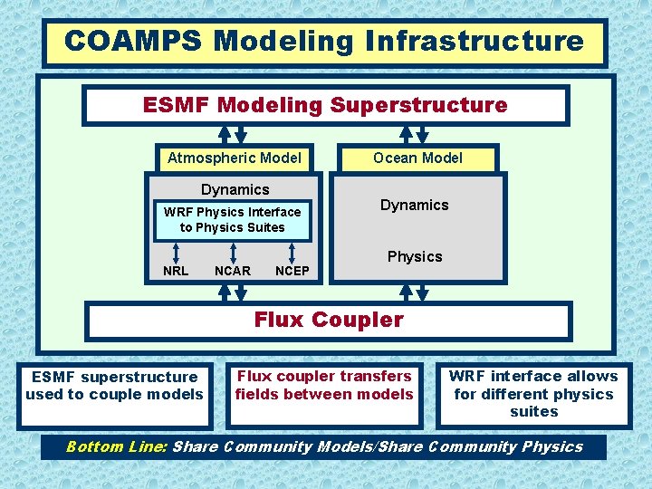
COAMPS Modeling Infrastructure ESMF Modeling Superstructure Atmospheric Model Dynamics WRF Physics Interface to Physics Suites NRL NCAR NCEP Ocean Model Dynamics Physics Flux Coupler ESMF superstructure used to couple models Flux coupler transfers fields between models WRF interface allows for different physics suites Bottom Line: Share Community Models/Share Community Physics

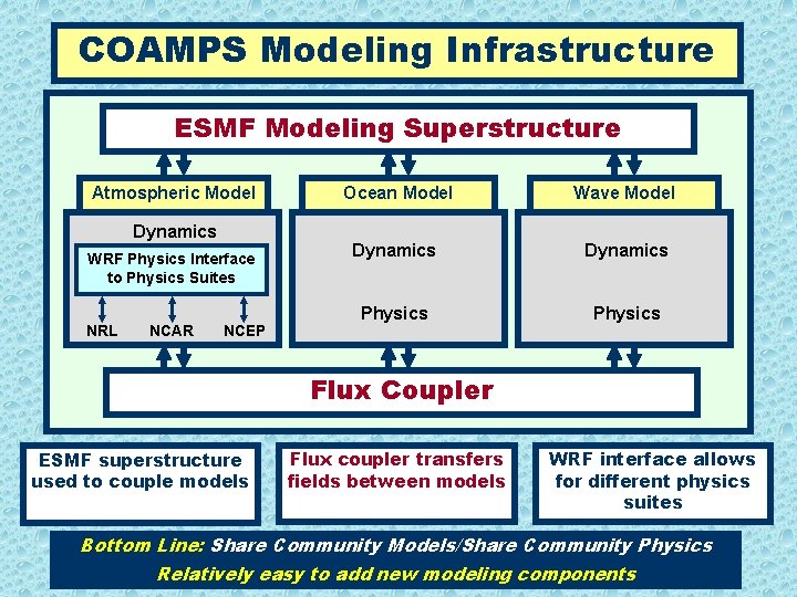
COAMPS Modeling Infrastructure ESMF Modeling Superstructure Atmospheric Model Dynamics WRF Physics Interface to Physics Suites NRL NCAR NCEP Ocean Model Wave Model Dynamics Physics Flux Coupler ESMF superstructure used to couple models Flux coupler transfers fields between models WRF interface allows for different physics suites Bottom Line: Share Community Models/Share Community Physics Relatively easy to add new modeling components

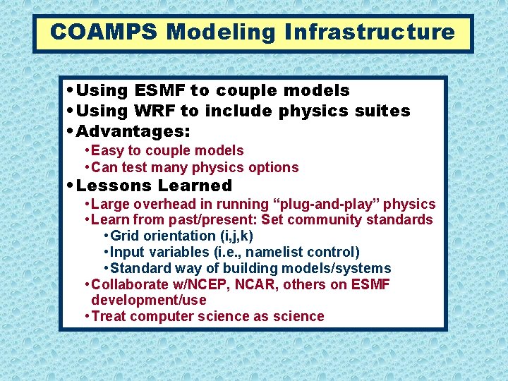
COAMPS Modeling Infrastructure • Using ESMF to couple models • Using WRF to include physics suites • Advantages: • Easy to couple models • Can test many physics options • Lessons Learned • Large overhead in running “plug-and-play” physics • Learn from past/present: Set community standards • Grid orientation (i, j, k) • Input variables (i. e. , namelist control) • Standard way of building models/systems • Collaborate w/NCEP, NCAR, others on ESMF development/use • Treat computer science as science

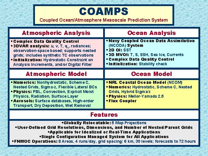
COAMPS Coupled Ocean/Atmosphere Mesoscale Prediction System Atmospheric Analysis • Complex Data Quality Control • 3 DVAR analysis: u, v, T, qv, radiances; observation-space based; supports nested grids; includes synthetic TC observations • Initialization: Hydrostatic Constraint on Analysis Increments, and/or Digital Filter Ocean Analysis • Navy Coupled Ocean Data Assimilation (NCODA) System • 2 D OI: SST • 3 D MVOI: T, S, SSH, Sea Ice, Currents • Complex Data Quality Control • Initialization: Stability check Atmospheric Model Ocean Model • Numerics: Nonhydrostatic, Scheme C, Nested Grids, Sigma-z, Flexible Lateral BCs • Physics: PBL, Convection, Explicit Moist Physics, Radiation, Surface Layer • Aerosols: Surface databases, High-order Transport, Dry Deposition, Wet Removal • NRL Coastal Ocean Model (NCOM) • Numerics: Hydrostatic, Scheme C, Nested Grids, Hybrid Sigma/z • Physics: Mellor-Yamada 2. 5 • Flux Coupler Features • Globally Relocatable: 5 Map Projections • User-Defined Grid Resolutions, Dimensions, and Number of Nested/Parent Grids • Applicable for Idealized or Real-Time Applications • Single Configuration Managed System for All Applications • FNMOC Operations: 8 Areas, 4 runs/day, grid spacing: 6 km, 30 levels; forecasts to 72 hours

NRL Monterey Plans for Tropical Cyclone Modeling using COAMPS Outline • Introduction/Background • Modeling Infrastructure • TC Related Research • Analysis/Initialization • Boundary Layer • Moving, Nested Grids • Air/Ocean Coupling • Ensemble Prediction • Summary

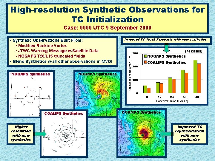
High-resolution Synthetic Observations for TC Initialization Case: 0000 UTC 9 September 2000 NOGAPS Synthetics Improved TC Track Forecasts with new synthetics Forecast Track Error (km) • Synthetic Observations Built From: • Modified Rankine Vortex • JTWC Warning Message w/Satellite Data • NOGAPS T 20/L 15 truncated fields • Blend Synthetics w/all other observations in MVOI (74 cases) NOGAPS Synthetics COAMPS Synthetics Forecast Time (Hours) COAMPS Synthetics Higher resolution with new synthetics COAMPS Synthetics Improved TC representation with new synthetics

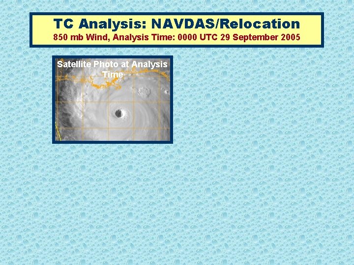
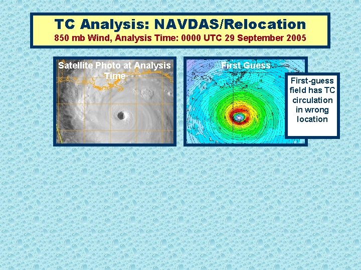
TC Analysis: NAVDAS/Relocation 850 mb Wind, Analysis Time: 0000 UTC 29 September 2005 Satellite Photo at Analysis Time

TC Analysis: NAVDAS/Relocation 850 mb Wind, Analysis Time: 0000 UTC 29 September 2005 Satellite Photo at Analysis Time First Guess First-guess field has TC circulation in wrong location

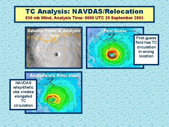
TC Analysis: NAVDAS/Relocation 850 mb Wind, Analysis Time: 0000 UTC 29 September 2005 Satellite Photo at Analysis Time Analysis w/o Relocation NAVDAS w/synthetic obs creates elongated TC circulation First Guess First-guess field has TC circulation in wrong location

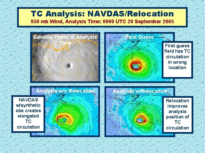
TC Analysis: NAVDAS/Relocation 850 mb Wind, Analysis Time: 0000 UTC 29 September 2005 Satellite Photo at Analysis Time First Guess Analysis w/o Relocation Analysis w/Relocation NAVDAS w/synthetic obs creates elongated TC circulation First-guess field has TC circulation in wrong location Relocation improves analysis position of TC circulation

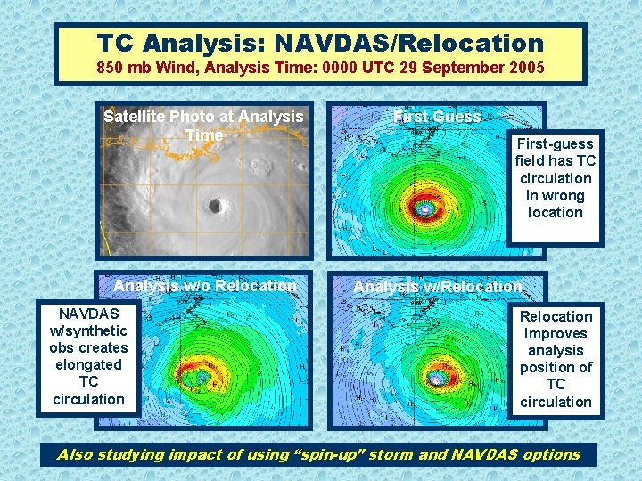
TC Analysis: NAVDAS/Relocation 850 mb Wind, Analysis Time: 0000 UTC 29 September 2005 Satellite Photo at Analysis Time First Guess Analysis w/o Relocation Analysis w/Relocation NAVDAS w/synthetic obs creates elongated TC circulation First-guess field has TC circulation in wrong location Relocation improves analysis position of TC circulation Also studying impact of using “spin-up” storm and NAVDAS options

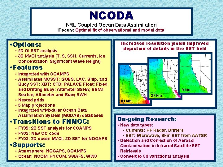
NCODA NRL Coupled Ocean Data Assimilation Focus: Optimal fit of observational and model data • Options: • 2 D OI SST analysis • 3 D MVOI analysis (T, S, SSH, Currents, Ice Concentration, Significant Wave Height) Increased resolution yields improved depiction of details in the SST field • Features • Integrated with COAMPS • Assimilates MCSST; GOES, LAC, Ship, and Buoy SST; XBT; CTD; PALACE Float; Fixed and Drifting Buoy; Altimeter SSHA; SSM/I Sea Ice; Altimeter and Buoy SWH • Nested grids • 5 Map projections • Integrated w/Modular Ocean Data Assimilation System (MODAS) databases • Transitions to FNMOC: • FY 99: 2 D SST analysis for COAMPS • FY 02: New QC code • FY 03: 3 D ocean MVOI; 2 D SST for NOGAPS • Supports: • Atmosphere: NOGAPS, COAMPS • Ocean: NCOM, HYCOM, SWAFS, WW 3 9 km 27 km 81 km On-going Research: • New data types: • Currents: HF Radar, Drifters • SST: Microwave, Skin SST from AATSR • Detection and Correction of Aerosol Contamination in Infrared Satellite SST Retrievals • Convert to 3 d variational analysis

NRL Monterey Plans for Tropical Cyclone Modeling using COAMPS Outline • Introduction/Background • Modeling Infrastructure • TC Related Research • Analysis/Initialization • Boundary Layer • Moving, Nested Grids • Air/Ocean Coupling • Ensemble Prediction • Summary

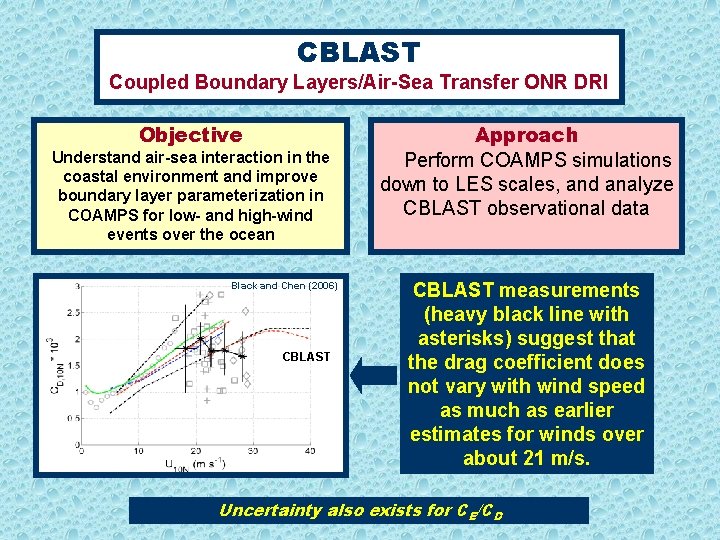
CBLAST Coupled Boundary Layers/Air-Sea Transfer ONR DRI Objective Understand air-sea interaction in the coastal environment and improve boundary layer parameterization in COAMPS for low- and high-wind events over the ocean Black and Chen (2006) CBLAST Approach Perform COAMPS simulations down to LES scales, and analyze CBLAST observational data CBLAST measurements (heavy black line with asterisks) suggest that the drag coefficient does not vary with wind speed as much as earlier estimates for winds over about 21 m/s. Uncertainty also exists for CE/CD

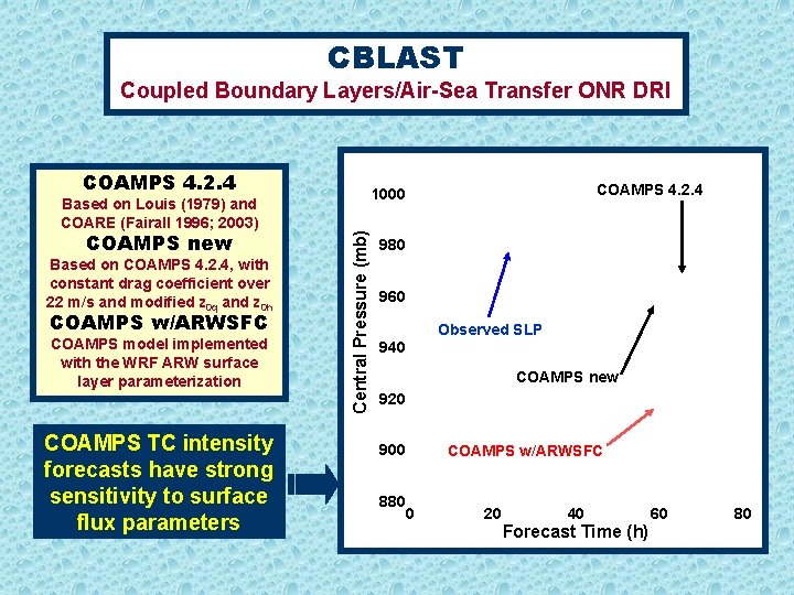
CBLAST Coupled Boundary Layers/Air-Sea Transfer ONR DRI COAMPS 4. 2. 4 COAMPS new Based on COAMPS 4. 2. 4, with constant drag coefficient over 22 m/s and modified z 0 q and z 0 h COAMPS w/ARWSFC COAMPS model implemented with the WRF ARW surface layer parameterization COAMPS TC intensity forecasts have strong sensitivity to surface flux parameters COAMPS 4. 2. 4 1000 Central Pressure (mb) Based on Louis (1979) and COARE (Fairall 1996; 2003) 980 960 Observed SLP 940 COAMPS new 920 900 880 0 COAMPS w/ARWSFC 20 40 Forecast Time (h) 60 80

NRL Monterey Plans for Tropical Cyclone Modeling using COAMPS Outline • Introduction/Background • Modeling Infrastructure • TC Related Research • Analysis/Initialization • Boundary Layer • Moving, Nested Grids • Air/Ocean Coupling • Ensemble Prediction • Summary

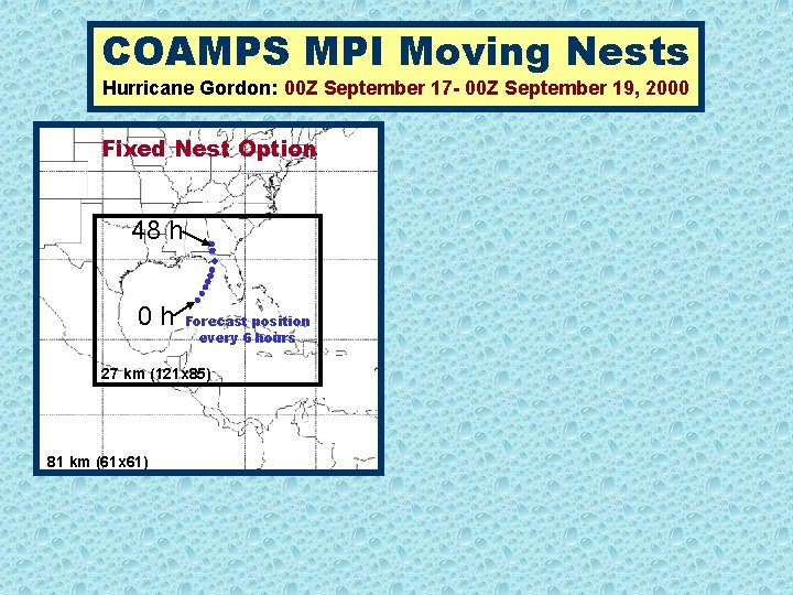
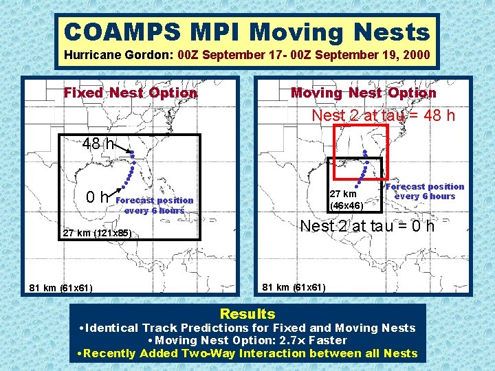
COAMPS MPI Moving Nests Hurricane Gordon: 00 Z September 17 - 00 Z September 19, 2000 Fixed Nest Option 48 h 0 h Forecast position every 6 hours 27 km (121 x 85) 81 km (61 x 61)

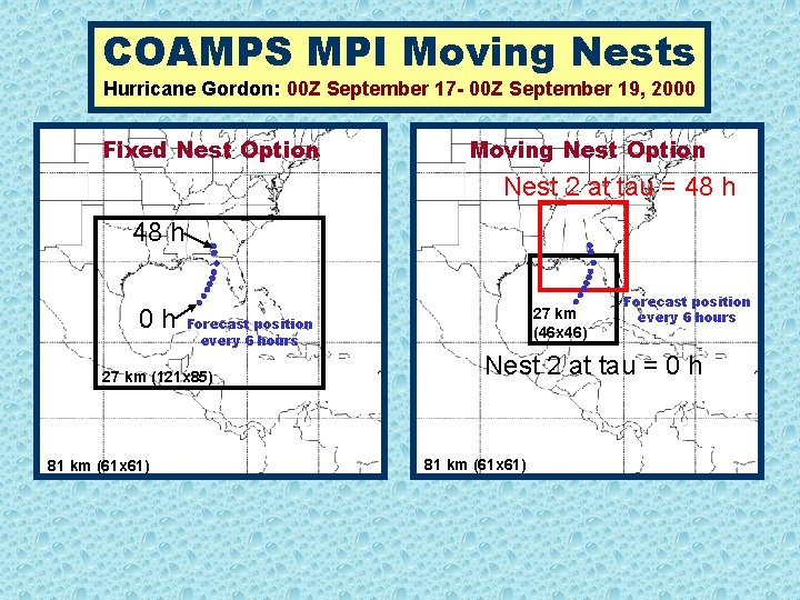
COAMPS MPI Moving Nests Hurricane Gordon: 00 Z September 17 - 00 Z September 19, 2000 Fixed Nest Option Moving Nest Option Nest 2 at tau = 48 h 0 h Forecast position every 6 hours 27 km (121 x 85) 81 km (61 x 61) 27 km (46 x 46) Forecast position every 6 hours Nest 2 at tau = 0 h 81 km (61 x 61)

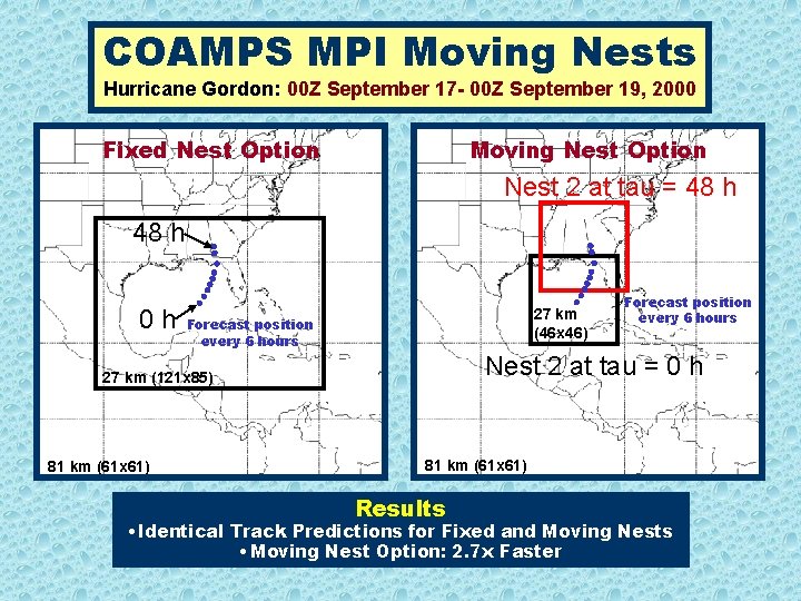
COAMPS MPI Moving Nests Hurricane Gordon: 00 Z September 17 - 00 Z September 19, 2000 Fixed Nest Option Moving Nest Option Nest 2 at tau = 48 h 0 h 27 km (46 x 46) Forecast position every 6 hours Nest 2 at tau = 0 h 27 km (121 x 85) 81 km (61 x 61) Forecast position every 6 hours 81 km (61 x 61) Results • Identical Track Predictions for Fixed and Moving Nests • Moving Nest Option: 2. 7 x Faster

COAMPS MPI Moving Nests Hurricane Gordon: 00 Z September 17 - 00 Z September 19, 2000 Fixed Nest Option Moving Nest Option Nest 2 at tau = 48 h 0 h 27 km (46 x 46) Forecast position every 6 hours Nest 2 at tau = 0 h 27 km (121 x 85) 81 km (61 x 61) Forecast position every 6 hours 81 km (61 x 61) Results • Identical Track Predictions for Fixed and Moving Nests • Moving Nest Option: 2. 7 x Faster • Recently Added Two-Way Interaction between all Nests

NRL Monterey Plans for Tropical Cyclone Modeling using COAMPS Outline • Introduction/Background • Modeling Infrastructure • TC Related Research • Analysis/Initialization • Boundary Layer • Moving, Nested Grids • Air/Ocean Coupling • Ensemble Prediction • Summary

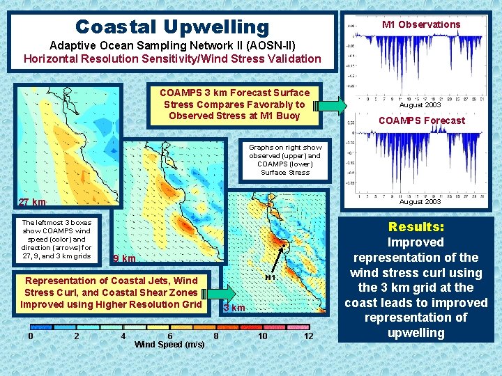
Coastal Upwelling M 1 Observations Adaptive Ocean Sampling Network II (AOSN-II) Horizontal Resolution Sensitivity/Wind Stress Validation COAMPS 3 km Forecast Surface Stress Compares Favorably to Observed Stress at M 1 Buoy August 2003 COAMPS Forecast Graphs on right show observed (upper) and COAMPS (lower) Surface Stress 27 km August 2003 The leftmost 3 boxes show COAMPS wind speed (color) and direction (arrows) for 27, 9, and 3 km grids 9 km M 1 Representation of Coastal Jets, Wind Stress Curl, and Coastal Shear Zones Improved using Higher Resolution Grid 0 2 4 6 Wind Speed (m/s) 3 km 8 10 12 Results: Improved representation of the wind stress curl using the 3 km grid at the coast leads to improved representation of upwelling

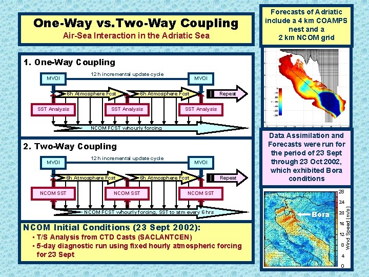
One-Way vs. Two-Way Coupling Air-Sea Interaction in the Adriatic Sea Forecasts of Adriatic include a 4 km COAMPS nest and a 2 km NCOM grid 1. One-Way Coupling 12 h incremental update cycle MVOI 6 h Atmosphere Fcst SST Analysis MVOI Repeat 6 h Atmosphere Fcst SST Analysis NCOM FCST w/hourly forcing 2. Two-Way Coupling 12 h incremental update cycle MVOI 6 h Atmosphere Fcst NCOM SST Repeat Data Assimilation and Forecasts were run for the period of 23 Sept through 23 Oct 2002, which exhibited Bora conditions 28 NCOM SST NCOM FCST w/hourly forcing, SST to atm every 6 hrs NCOM Initial Conditions (23 Sept 2002): • T/S Analysis from CTD Casts (SACLANTCEN) • 5 -day diagnostic run using fixed hourly atmospheric forcing for 23 Sept Bora 20 16 12 8 4 0 Wind Speed (m/s) 24

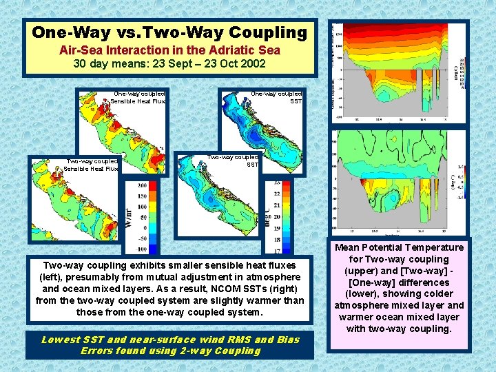
One-Way vs. Two-Way Coupling Air-Sea Interaction in the Adriatic Sea 30 day means: 23 Sept – 23 Oct 2002 One-way coupled Sensible Heat Flux Two-way coupled Sensible Heat Flux One-way coupled SST Two-way coupling exhibits smaller sensible heat fluxes (left), presumably from mutual adjustment in atmosphere and ocean mixed layers. As a result, NCOM SSTs (right) from the two-way coupled system are slightly warmer than those from the one-way coupled system. Lowest SST and near-surface wind RMS and Bias Errors found using 2 -way Coupling Mean Potential Temperature for Two-way coupling (upper) and [Two-way] [One-way] differences (lower), showing colder atmosphere mixed layer and warmer ocean mixed layer with two-way coupling.

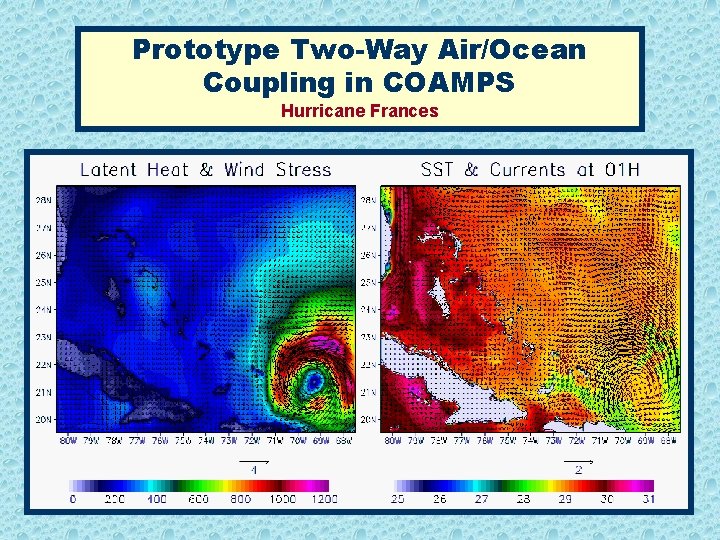
Prototype Two-Way Air/Ocean Coupling in COAMPS Hurricane Frances

NRL Monterey Plans for Tropical Cyclone Modeling using COAMPS Outline • Introduction/Background • Modeling Infrastructure • TC Related Research • Analysis/Initialization • Boundary Layer • Moving, Nested Grids • Air/Ocean Coupling • Ensemble Prediction • Summary

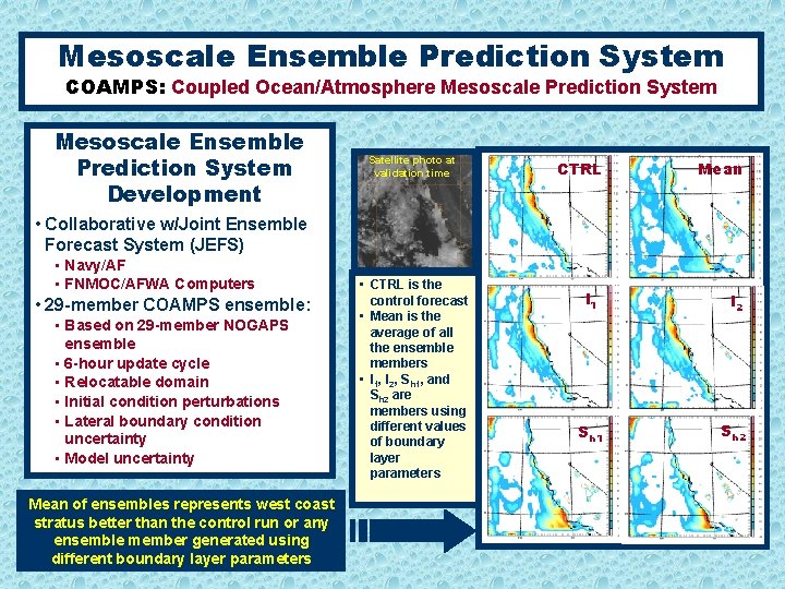
Mesoscale Ensemble Prediction System COAMPS: Coupled Ocean/Atmosphere Mesoscale Prediction System Mesoscale Ensemble Prediction System Development Satellite photo at validation time CTRL Mean • Collaborative w/Joint Ensemble Forecast System (JEFS) • Navy/AF • FNMOC/AFWA Computers • 29 -member COAMPS ensemble: • Based on 29 -member NOGAPS ensemble • 6 -hour update cycle • Relocatable domain • Initial condition perturbations • Lateral boundary condition uncertainty • Model uncertainty Mean of ensembles represents west coast stratus better than the control run or any ensemble member generated using different boundary layer parameters • CTRL is the control forecast • Mean is the average of all the ensemble members • I 1, I 2, Sh 1, and Sh 2 are members using different values of boundary layer parameters l 1 l 2 Sh 1 Sh 2

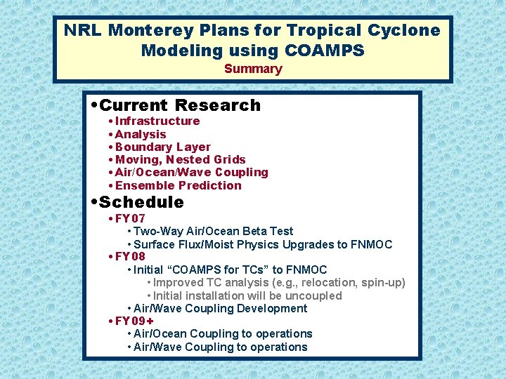
NRL Monterey Plans for Tropical Cyclone Modeling using COAMPS Summary • Current Research • Infrastructure • Analysis • Boundary Layer • Moving, Nested Grids • Air/Ocean/Wave Coupling • Ensemble Prediction • Schedule • FY 07 • Two-Way Air/Ocean Beta Test • Surface Flux/Moist Physics Upgrades to FNMOC • FY 08 • Initial “COAMPS for TCs” to FNMOC • Improved TC analysis (e. g. , relocation, spin-up) • Initial installation will be uncoupled • Air/Wave Coupling Development • FY 09+ • Air/Ocean Coupling to operations • Air/Wave Coupling to operations

NRL Monterey Plans for Tropical Cyclone Modeling using the Coupled Ocean/Atmosphere Mesoscale Prediction System (COAMPS) 61 st Interdepartmental Hurricane Conference, New Orleans, LA 6 March 2007 Richard M. Hodur Marine Meteorology Division Naval Research Laboratory Monterey, CA COAMPS® is a registered trademark of the Naval Research Laboratory