North Carolina Land of Contrasts Chapter 1 The


 along")


- Slides: 42
North Carolina: Land of Contrasts Chapter 1 The Lay of the Land Study Presentation
Chapter 1: The Lay of the Land • • • Section 1: The Tidewater Region Section 2: The Coastal Plain Region Section 3: The Piedmont Region Section 4: The Mountains Region Section 5: North Carolina’s Weather and Climate
Section 1: The Tidewater Region ESSENTIAL QUESTION – What are the major features of the Tidewater Region? Vocabulary 1. 2. 3. 4. sound barrier islands inlet Gulf Stream 5. 6. 7. 8. wetland estuary pocosin savanna
Section 1: The Tidewater Region
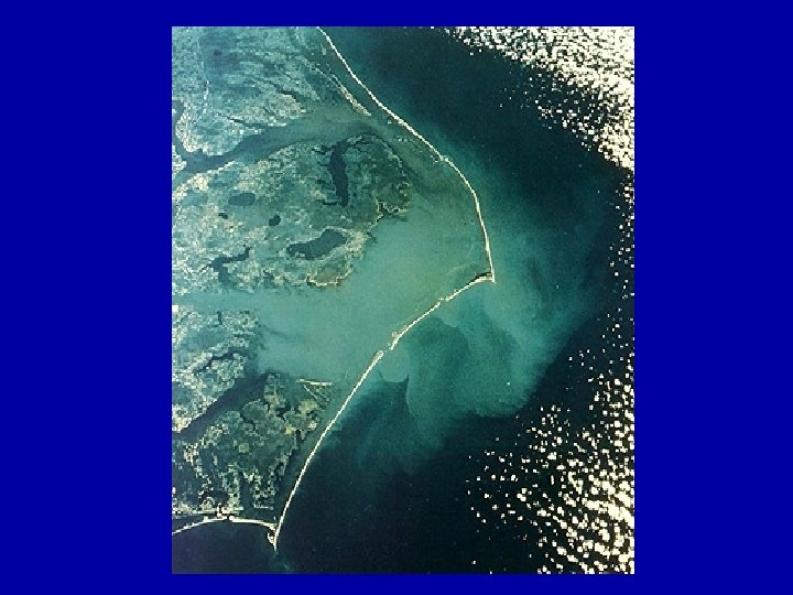
I. Section 1: The Tidewater Region A. Narrow strip of North Carolina (NC) along the Atlantic Ocean 1. 30 -50 miles wide 2. Tides affect the region’s water 3. Sounds: inland bodies of salt/fresh water mix
B. Barrier Islands 1. Islands form the beach of the Tidewater 2. Part of a chain of sand pits sticking up out of the ocean near the shore 3. Most less than two miles across, barely above sea level, and ever changing due to surf and wind 4. The Outer Banks are the most famous barrier islands 5. At Cape Hatteras islands are widest a. “Graveyard of the Atlantic”: nickname for waters near Cape Hatteras – dangerous due to storms caused by warm Gulf Stream colliding with cold Labrador Current 6. Cape Fear: true break in the island chain; Cape Fear River flows directly into the Atlantic
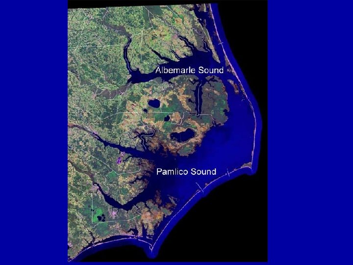
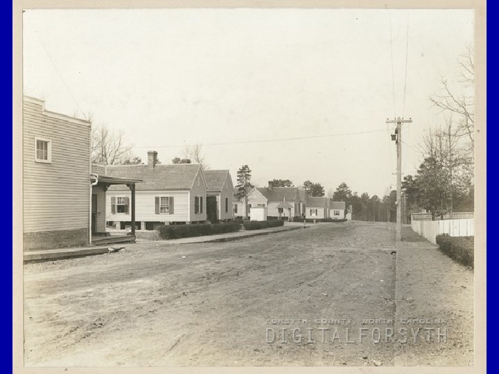
C. The Sounds 1. Each sound fed by fresh water river 2. Oldest towns in NC near the sounds 3. Great location for trade along river routes and ocean 4. Fishing is an important industry 5. Sediment (soil, clay, gravel) is deposited by the rivers in the sounds – makes them too shallow for large ships Largest Sounds Currituck Albemarle Pamlico Core Bogue
Section 2: The Coastal Plain Region ESSENTIAL QUESTION – What are the major features of the Coastal Plain Region? Vocabulary 1. crossroads hamlets 2. tobacco towns 3. Carolina bays
Section 2: The Coastal Plain Region
II. Section 2: The Coastal Plain Region A. Introduction to Coastal Plain 1. Stretches from Virginia to South Carolina and about 100 miles wide 2. Covers about 1/3 of the state 3. Rich soil and flat land make area good for farming
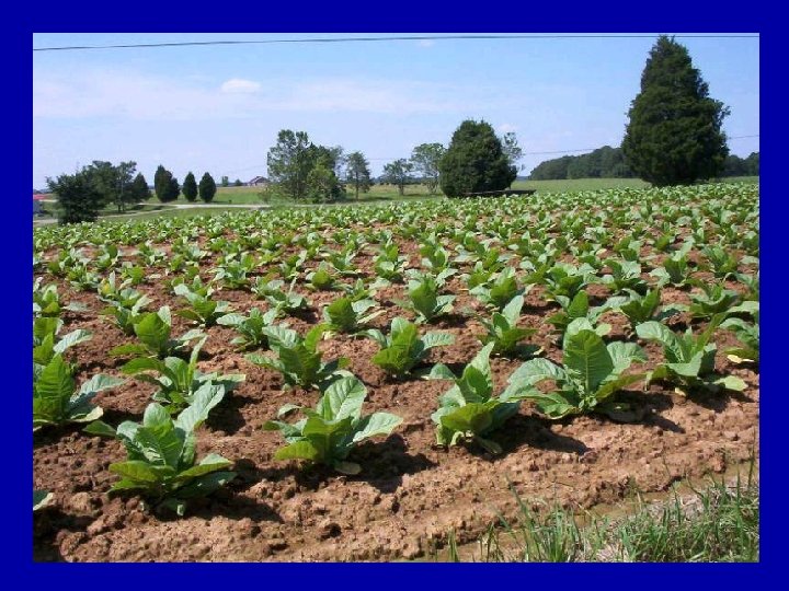
B. Types of Communities 1. Crossroads hamlets: serve rural areas, usually a one or two stores, church, school, etc. 2. Tobacco Towns a. Life and culture were dominated by tobacco farming b. Largest tobacco growing area in the world c. Longleaf pines were original plants of the region; millions of acres cut down for tobacco farming
C. The Sand Hills 1. Sandy, rolling ridges left by ancient coast of the Atlantic Ocean 2. Very poor soil 3. Used as home for golf courses and Fort Bragg military installation Click here to return to Main Menu.
Section 3: The Piedmont Region ESSENTIAL QUESTION – What are the major features of the Piedmont Region? Vocabulary 1. 2. 3. 4. 5. 6. fall line headwaters sectionalism mill village NASCAR monadnock
Section 3: The Piedmont Region
III. Section 3: The Piedmont Region A. Large region of NC known for hills and red clay soil 1. Red clay is a subsoil brought up through the black woods dirt as a result of timber loss and plowing fields 2. Kudzu brought from Asia to reduce erosion and save the soil a. This fast growing vine has grown like a weed and covered thousands of acres in the state
B. Fall Line 1. Fall line: divides the coastal plain from the Piedmont – noted by the last “waterfall” a river hits on its way to the ocean 2. Piedmont: from Latin, means “foot of the mountains”
C. Importance of Rivers 1. Principal rivers: Yadkin-Pee Dee and Catawba – flow into South Carolina 2. River “highways” connected people in western NC with SC more than they did with eastern NC, resulting in “sectionalism”
D. Forests 1. Over ½ of region is forests; pines cover old farms 2. biological succession: fast-growing pines die off and give way to oaks and hickory trees
E. Farms and Factories 1. Soil made farming difficult in the Piedmont 2. Livestock and dairy farms were more profitable, but have declined 3. Economy of the region has depended on factories to produce textiles, furniture and cigarettes 4. mill villages: clusters of homes in a town where mill workers lived; the company often provided the homes, schools, and stores 5. 1990 s: decline in industry 6. Textile and furniture factories moved to Asia
F. Banking and Racing 1. Charlotte: national banking center and home to NASCAR, and NASCAR Hall of Fame 2. Winston-Salem and Durham have grown in medical service industries linked to Wake Forest and Duke Universities 3. Salisbury: home to grocery industry 4. Research Triangle Park: leader in pharmaceuticals and computers
G. The Uwharries 1. Monadnocks: geological formation in which a point of land sticks out due to erosion of surrounding land (ex. Pilot Mountain on pages 3 and 24) 2. Uwharrie Mountains: cluster of monadnocks south of Greensboro (ex. Morrow Mountain) – slopes and slate soil discouraged settlement 3. Piedmont Crescent: string of towns from Raleigh to Charlotte Click here to return to Main Menu.
Section 4: The Mountains Region ESSENTIAL QUESTION – What are the major features of the Mountains Region? Vocabulary 1. elevation 2. bald 3. cove
Section 4: The Mountains Region
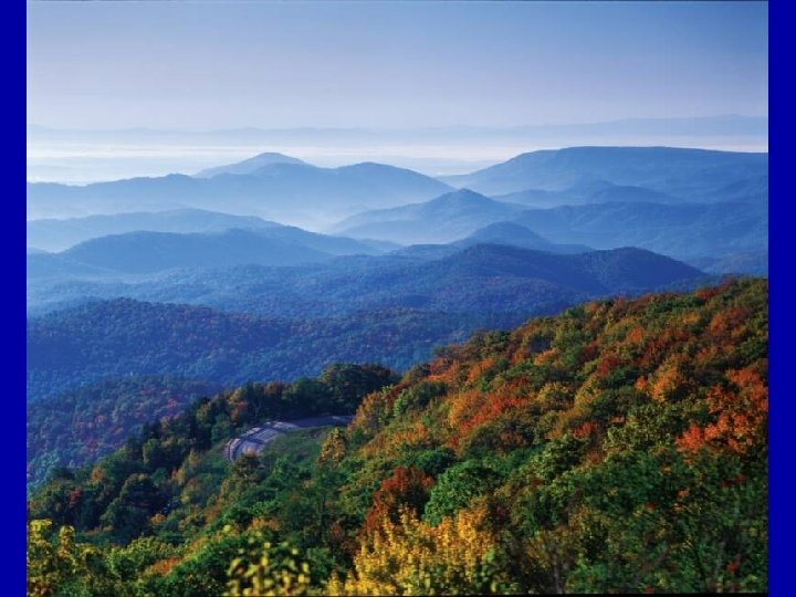
IV. Section 4: The Mountains Region A. Introduction to the Mountains 1. Blue Ridge: more than 1, 000 ft above the Piedmont hills; eastern boundary of the Appalachians 2. Blue Ridge Parkway: road that runs along the top of the ridge – Cherokee NC to Waynesboro, VA 3. Continental Divide – steams on the east run to the Atlantic; streams on the west run to the Gulf of Mexico
B. The Blue Ridge 1. Runs from Pennsylvania to Georgia 2. One long landform (like the barrier islands) with peaks and gaps 3. Early settlers depended on gaps to get through the mountains 4. Areas in the west very isolated 5. 1870 s: tunnels and road beds laid through Swannanoa Gap – near current I-40 from Old Fort to Black Mountain
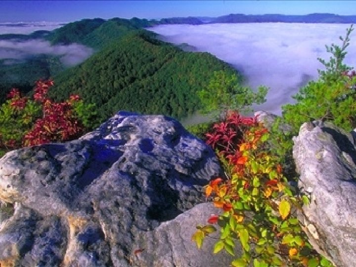
C. The Appalachians 1. Run from New York to Alabama 2. 43 peaks in NC over 6, 000 feet 3. Mt. Mitchell (6, 684 ft): highest point east of the Rockies 4. Ranges a. Black Mountains: known for dark shadows during thunderstorms b. Great Smoky Mountains: dew rises in mists creating a smoky effect; tallest peaks are Clingman’s Dome and Mt. Guyot; great variety of plants c. Balsams: large number of balds (places where few trees grow) example: Wayah Bald
D. The Mountains Economy 1. Early settlers isolated from others 2. Farming, traveling, trading were more difficult 3. Towns developed in valley areas 4. Known for sales of local plants with medicinal properties 5. Tourism is a major industry 6. Christmas tree is a new and growing industry; Fraser firs most popular Click here to return to Main Menu.
Section 5: North Carolina’s Weather and Climate ESSENTIAL QUESTION – What are characteristics of North Carolina’s climate? • What words do I need to know? 1. 2. 3. 4. 5. 6. 7. weather climate westerlies humidity precipitation tornado hurricane
V. Section 5: North Carolina’s Weather and Climate A. Difference between weather and climate 1. weather: short-term atmospheric conditions 2. climate: long-term atmospheric conditions B. Temperate climate 1. general climate zone for NC 2. known for few extremes of temperature or precipitation during the year 3. Day-to-day weather varies
C. “It’s Not the Heat; It’s the Humidity” 1. Westerly winds bring warmer air in the winter and cooler air in the summer – keeps temperatures similar across the state 2. Mountain peaks usually coldest a. -34°F: record cold at Mt. Mitchell (1985) 3. Sand hills usually the warmest 4. Humidity (moisture in the air) can make temperatures feel uncomfortably warm
D. Different Storms in Different Places 1. Precipitation rates vary across the state a. SW mountains get most rain b. Piedmont is the driest region (precipitation is blocked by the mountains) c. Mountains get most of the state’s snow 2. Thunderstorms occur all over NC in summer 3. NC is third in US in deaths due to lightning
E. The Path of Hurricanes 1. Hurricane damage sources: a. storm surge (huge tide on the beach) b. wind (can destroy homes, trees, property) c. flooding (slowing storm rapidly dumps the tropical rain) 2. Notable hurricanes: a. 1845, cut two inlets b. Hazel (1954) winds over 150 mph c. Floyd (1999) several towns in coastal plain flooded d. Hugo (1989) power outages for weeks 3. Hurricane season: June – November Click here to return to Main Menu.