MADIS Project Report for RITT MADIS Meteorological Assimilated
- Slides: 22
MADIS Project Report for RITT MADIS Meteorological Assimilated Data Ingest System Steve Pritchett NWS MADIS Transition Project Manager 08/15/2012
Agenda • MADIS Refresher • MADIS Purpose/Business case • MADIS Transition from Research to Operations
MADIS Program overview • The National Oceanic and Atmospheric Administration (NOAA) Research (Oceanic and Atmospheric Research) Earth System Research Laboratory (ESRL) Global Systems Division (GSD) developed the Meteorological Assimilation Data Ingest System (MADIS) to collect, integrate, quality control (QC), and distribute observations from NOAA and non-NOAA organizations. MADIS leverages partnerships with international agencies; federal, state, and local agencies (e. g. state Departments of Transportation); universities; volunteer networks; and the private sector (e. g. airlines, railroads) to integrate observations from their stations with those of NOAA to provide a finer density, higher frequency observational database for use by the greater meteorological community. MADIS observational products and services were first provided to the public in July of 2001. – – In excess of 60 K non-NOAA unique observing platforms Provides QC, data formatting and distribution OAR and NWS have jointly developed since 2001 System run by OAR as research system until 2010 when NWS initial operating capability achieved by transition team. – Supplementary data valued by WFOs – MADIS HOME
MADIS Data Sources • Datasets • Meteorological Surface – METAR (standard) – High Frequency METAR (experimental) – SAO – Maritime – New England Pilot Project (NEPP) – National Mesonet/Urba. Net – Integrated Mesonet – Climate Reference Network (CRN) – U. S. Historical Climatology Network - Modernization (USHCN-M) Radiosonde NOAA Profiler Network Hydrological Surface Automated Aircraft – Automated Aircraft Reports – Profiles at Airports Multi-Agency Profiler Radiometer Satellite Wind – GOES Operational 3 -Hour – GOES Experimental 1 -Hour Satellite Sounding – NOAA POES Satellite Radiance – NOAA POES Snow WISDOM Balloon Wind • • •
MADIS Data sources • • • Some of the datasets are restricted to certain users Distribution to government, research, and education organizations Public - Full distribution Distribution to NOAA only. The following datasets are available without restriction: – Meteorological Surface (non-mesonet) – Radiosonde – NOAA Profiler Network – Multi-Agency Profiler – Radiometer – Satellite Wind – Satellite Sounding – Satellite Radiance – Snow – WISDOM Balloon Wind – RSAS Surface Analyses The following datasets are available with some restrictions: * – Automated Aircraft – Hydrological Surface (mesonet) – Meteorological Surface (integrated mesonet) – Meteorological Surface (National Mesonet/Urba. Net)
Data sources • • Some of the datasets are restricted to certain users. Those receiving these datasets are expected to comply with the restrictions. Click here for details The datasets in the MADIS database are stored in net. CDF files. While users can write their own programs to read the files, to access the observations they are encouraged to use the MADIS Applications Program Interface (API) or its related utility programs, which allow easy access to the data and hide most of the details required to write a data ingest program to access variables from the net. CDF files. For surface observaions, XML and different text formats can also be returned by the MADIS Text/XML Viewer web service. For the RSAS grids, the MADIS RSASDUMP program can be used to output the grids in plain text. While many of the datasets are global, observations with the highest spatial and temporal density exit in North America.
MADIS Data users • • • Data Application : MADIS subscribers can receive real-time data or obtain access to an on-line archive of saved real -time data by requesting an ftp, OPe. NDAP or Text/XML Viewer account. For real-time data, LDM access is also available. OPe. NDAP and Text/XML Viewer accounts are recommended for those who have a need for data on-demand, as contrasted with continuous real-time access. In general, users who require a continuous datafeed will get better performance by accessing the data via ftp or LDM. Also note that at this time, the Text/XML Viewer can only be used for the surface observation datasets. Public MADIS Meteorological and Hydrological Surface datasets can be viewed in either text or XML formats. The unrestricted data are available from the links below. All users should read the Data Use Policy and the Disclaimer in the MADIS Data Application. Users eligible for the restricted mesonets should request a Text/XML Viewer account. Observation Displays ESRL/GSD Displays – Meteorological Surface – Upper Air Soundings – Automated Aircraft (restricted) – Multi-Agency Profiler Other Displays – NWS NOAA Profiler Network – NOHRSC Snow Depth – NOHRSC Snow Water Equivalent of Snowdepth – NOHRSC Snowfall Last 24 Hours – NOAA/NOS now. COAST Web Mapping Portal
Data Users • • • MADIS subscribers have access to an integrated, reliable, and easy-to-use database containing the real-time and saved real-time observational datasets described below. Also available are real-time gridded surface analyses that assimilate all of the MADIS surface datasets (including the highly-dense integrated mesonet data). The grids are produced by the Rapid Update Cycle (RUC) Surface Assimilation System (RSAS), which incorporates a 15 -km grid stretching from Alaska in the north to Central America in the south, and also covers significant oceanic areas. The RSAS grids are valid at the top of each hour, and are updated every 15 minutes. Since the inception of the MADIS project in 2001, over 700 individuals and institutions have requested access to MADIS data streams and services. A representative list of users in the public, private, academic and international sectors provided on the following slide. Public MADIS Meteorological and Hydrological Surface datasets can be viewed in either text or XML formats. The unrestricted data are available from the links below. All users should read the Data Use Policy and the Disclaimer in the MADIS Data Application. Users eligible for the restricted mesonets should request a Text/XML Viewer account. – Meteorological Surface – Hydrological Surface
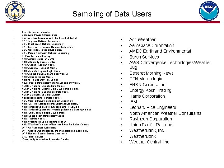
Sampling of Data Users • • • • • • • • • • Army Research Laboratory Bonneville Power Administration Denver Urban Drainage and Flood Control District DOE Argonne National Laboratory DOE Brookhaven National Laboratory DOE Lawrence Livermore National Laboratory DOE Oak Ridge National Laboratory DOE Pacific Northwest National Laboratory El Paso Merchant Energy NASA Ames Research Center NASA Kennedy Space Center NASA Glenn Research Center NASA Langley Research Center NASA Marshall Space Flight Center NASA Space Science Technology Center NASA Stennis Space Center National Interagency Fire Center Naval Pacific Meteorology and Oceanography Center NESDIS National Climatic Data Center NESDIS National Coastal Data Development Center NESDIS National Geophysical Data Center NESDIS Satellite Services Division Northeast Regional Climate Center NOS Coastal Survey Development Laboratory NWS OST Meteorological Development Laboratory NWS National Centers for Environmental Prediction NWS National Operational Hydrologic Remote Sensing Center NWS Office of Hydrologic Development NWS Space Flight Meteorology Group NWS Training Center NWS Warning Decision Training Branch NWS Weather Forecast Offices and River Prediction Centers OAR Air Resources Laboratory OAR Atlantic Oceanographic and Meteorological Laboratory OAR National Severe Storms Laboratory U. S. Forest Service Ventura City Watershed Protection District • • • • • Accu. Weather Aerospace Corporation AMEC Earth and Environmental Baron Services AWS Convergence Technologies/Weather Bug Deseret Morning News DTN Meteorlogix ENSR Corporation Entergy Koch Trading Harris Corporation IBM Leonard Rice Engineers North American Weather Consultants Raytheon Corporation Union Pacific Railroad Weather. Bank, Inc. Weather. Bonk Weather Central, Inc
Additional MADIS Information • • • Compatible Data Assimilation Software The links below provide information about, and downloads of, the data assimilation software packages that are directly compatible with the MADIS datasets. LAPS MADIS WRF-Var AMET Compatible Display Software The link below provides information about, and downloads of, the display software packages that are directly compatible with the MADIS datasets. Unidata Integrated Data Viewer (IDV) Observation Displays ESRL/GSD Displays – Meteorological Surface – Upper Air Soundings – Automated Aircraft (restricted) – Multi-Agency Profiler Other Displays – NWS NOAA Profiler Network – NOHRSC Snow Depth – NOHRSC Snow Water Equivalent of Snowdepth – NOHRSC Snowfall Last 24 Hours – NOAA/NOS now. COAST Web Mapping Portal
Archive • • Archive Script Package MADIS offer a script package for users who want to process a lot of MADIS data (e. g. , weeks-to-years). These scripts can be used to: Ftp the archive data to the local machine, set it up in the MADIS directory structure. Use the MADIS API dump programs to dump the data. Users who don't want to use the MADIS API can still use the ftp script to download the data. Download the proper script package for your system: Unix/Linux Windows
NWS Agreements required for Non-NOAA Providers (Incomplete sample) • • • • • • MADIS Data Provider Agreement for Government, Research, and Education (GRE)-only observation distribution I. The Parties A. The National Oceanic and Atmospheric Administration (NOAA) B. [Data provider] who wishes to provide observational data to eligible recipients II. Purpose NOAA wishes to include observational data within the Meteorological Assimilation Data Ingest System (MADIS). This agreement sets forth terms and conditions agreed upon by NOAA and the [data provider] with regard to NOAA’s receipt of observational data from the [data provider]. NOAA and [data provider] will work together to determine metadata, data communication, data coding, and formatting requirements which ensure compatibility with the NOAA MADIS systems located at NOAA operational centers and at the NOAA Office of Oceanic and Atmospheric's Earth System Research Laboratory Global Systems Division (ESRL/GSD). MADIS is an observation ingest, integration, quality control and distribution system, that integrates observations from multi-agency networks and provides them in uniformats to the community. [Data Provider] has requested that their data be placed in the MADIS Government, Research, and Education (GRE)-only distribution category. Access to observations and metadata in this category is restricted as described below. III. Undertaking For reasons beneficial to both parties, the parties agree to the following: A. [Data provider] will provide to NOAA a feed of its proprietary data. [Data provider] will provide this feed to NOAA at no charge. [Data provider] will incur all costs associated with collecting and delivering the data to NOAA recognizes and acknowledges the proprietary nature of the [data provider], and agrees to honor the restrictions of use reflected herein. B. The use of the data provided hereunder will be restricted as provided below. The data provided under this agreement may be used in any manner within NOAA, including incorporation within any information product or system of NOAA’s other line organizations. It is understood and agreed that NOAA will take appropriate steps to ensure that data users are aware of, and agree to abide by, the restrictions on re-distribution reflected herein. These restrictions will not apply under the following circumstances: a. NOAA may redistribute derivative products incorporating [data provider] data in whole or part, without attribution, as long as such derivative products do not have sufficient information to readily retrieve the original content of the [data provider] data provided under this agreement. b. In cases of emergencies, NOAA may distribute [data provider] data, in raw form or otherwise, to others as it deems appropriate under the circumstances. In all cases of such distribution of data, NOAA will notify [data provider] of the circumstances of such distribution as soon as is practical. c. When required by law. d. When given express written permission. 12
MADIS Purpose • The National Oceanic and Atmospheric Administration (NOAA) Research (Oceanic and Atmospheric Research) Earth System Research Laboratory (ESRL) Global Systems Division (GSD) developed the Meteorological Assimilation Data Ingest System (MADIS) to collect, integrate, quality control (QC), and distribute observations from NOAA and non-NOAA organizations. • MADIS leverages partnerships with international agencies; federal, state, and local agencies (e. g. state Departments of Transportation); universities; volunteer networks; and the private sector (e. g. airlines, railroads) to integrate observations from their stations with those of NOAA to provide a finer density, higher frequency observational database for use by the greater meteorological community. MADIS observational products and services were first provided to the public in July of 2001. 13
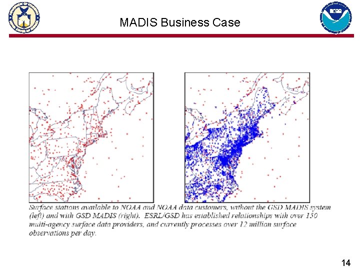
MADIS Business Case 14
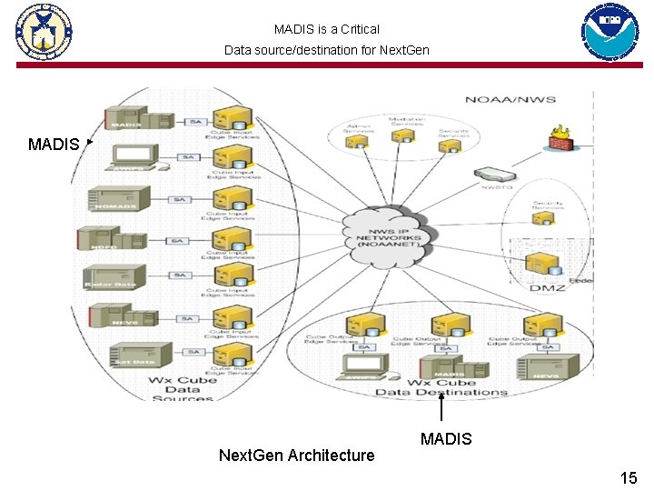
MADIS is a Critical Data source/destination for Next. Gen MADIS Next. Gen Architecture MADIS 15
MADIS Program overview – transition to operations • • MADIS has been a path finder in the NOAA research to operations transition push (2008 AGM priority) – 3 NOAA Line Offices cooperating in the transition – 2012 MADIS Letter of Agreement signed by NOAA AAs from OAR, NWS and NESDIS – R 20 transition Issues encountered between NOAA Line Offices with IT security, Policy, Budget, Staffing and understanding of roles and responsibilities Reason for transition to operations. MADIS is being transitioned to operations at the NWS to help improve performance for a wide-variety of service applications. – MADIS observations contribute to the reduction in the nation’s loss of life, property, and commerce caused by severe storms, drought, local high-impact weather, and toxic atmospheric plumes. – This is accomplished by: improving the density, usability, reliability, timeliness, and accuracy of the integrated surface and upper air observations used in local weather warning, model predictions, and hazardous situations; and by providing products in more easily accessible and usable formats that industry and society can better use to reduce risk and uncertainty, lower costs, and improve public safety and security.
MADIS R 20 History • Development – – – • OAR and NWS have jointly developed since 2001 Provides QC, data formatting and distribution Requires provider agreements, user subscriptions Several hundred providers, hundreds of users organizations In excess of 60 K non-NOAA unique observing platforms System run by OAR as research system between 2001 -2010 – Supplementary data valued by WFOs Transition to Operations – Transition to Operations effort began in 2007 in NWS Office of Operational Systems (OPS) – Independent Review Team in 2008 revised transition strategy • Distributed system I/O at NWS Gateway (NWSTG), QC at NCEP NCO – Transition effort moved to Office of Science and Technology (OST) in 2008 – NWS-OAR MADIS Letter of Agreement (LOA) signed October 2008 – OST MADIS PM change in May 2010 – IOC achieved in September 2010 – Transition to NWS Full Operating Capability (FOC) underway 2010 -2014 17
MADIS Transition Program Requirements • • • NWS MADIS IOC system is delivering products to users MADIS Transition to Operations - a NOAA Priority from the 2008 AGM MADIS is being transitioned to operations at the NWS to help improve performance for a wide-variety of service application MADIS is required by the NWS for meeting: – NOAA Strategic Plan requirements; – NWS Strategic plan requirements; – NWS Roadmap requirements; – NWS tactical requirements for: • AWIPS data ingest; • Next. Gen 4 D Cube; • NWP data assimilation and verification; • Situational awareness including Real-Time Mesoscale Analysis (RTMA); • WFO and River Forecast Centers (RFC) forecasts and warnings; The NWS MADIS at FOC will have a primary and backup system operated by the NWS with an archive supported by NCDC 18
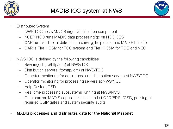
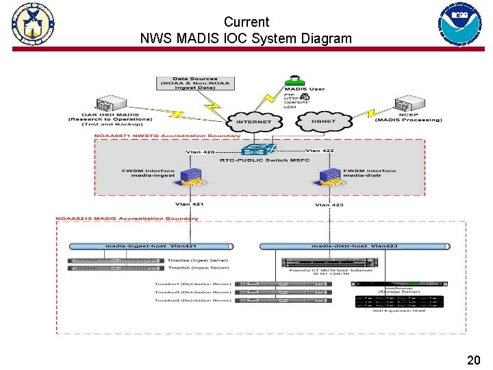
MADIS IOC system at NWS • Distributed System – NWS TOC hosts MADIS ingest/distribution component – NCEP NCO runs MADIS data processing/qc on NCO CCS – OAR runs additional data sets, archiving, help desk, and MADIS backup – OAR is Tier II O&M for TOC system and Tier III O&M for TOC and NCO • NWS IOC is defined by the following capabilities: – Raw ingest (ftp/http/ldm) at NWS/TOC – Distribution servers (ftp/http/ldm) at NWS/TOC – Operator monitoring for data ingest and distribution servers at NWS/TOC – Operator monitoring for processing servers at NWS/NCO – Help Desk at GSD – Real-time processing subsystems running at NWS/NCO – Other current MADIS capabilities sustained at OAR/ERSL/GSD, passing all required OSIP gates and system security audits • MADIS processes and distributes data for the National Mesonet 19
Current NWS MADIS IOC System Diagram 20
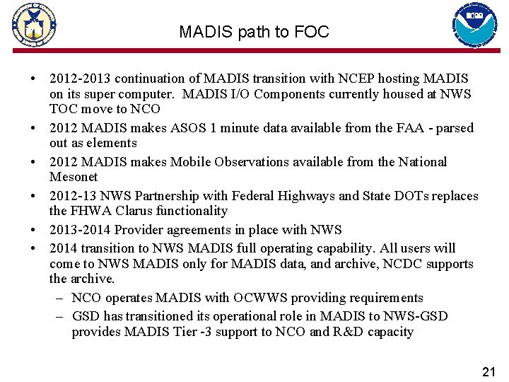
MADIS path to FOC • 2012 -2013 continuation of MADIS transition with NCEP hosting MADIS on its super computer. MADIS I/O Components currently housed at NWS TOC move to NCO • 2012 MADIS makes ASOS 1 minute data available from the FAA - parsed out as elements • 2012 MADIS makes Mobile Observations available from the National Mesonet • 2012 -13 NWS Partnership with Federal Highways and State DOTs replaces the FHWA Clarus functionality • 2013 -2014 Provider agreements in place with NWS • 2014 transition to NWS MADIS full operating capability. All users will come to NWS MADIS only for MADIS data, and archive, NCDC supports the archive. – NCO operates MADIS with OCWWS providing requirements – GSD has transitioned its operational role in MADIS to NWS-GSD provides MADIS Tier -3 support to NCO and R&D capacity 21
Questions – Steven. Pritchett@noaa. gov office 301 713 3557 ext 172 – Greg. Pratt@noaa. gov office 303 497 7237 22