Life in the Central Andes Adapting to a


- Slides: 15
Life in the Central Andes Adapting to a Mountainous Region
• List or draw six things you typically do every day. • You might include daily routines, such as riding the bus to school. • Or you might include activities, like going to soccer practice.
• List or draw three details about the physical geography of this location. • How might your routines and activities change if you lived here? • Why might they change? • How do you think the physical geography of this location influences the routines and activities of the people who live here?
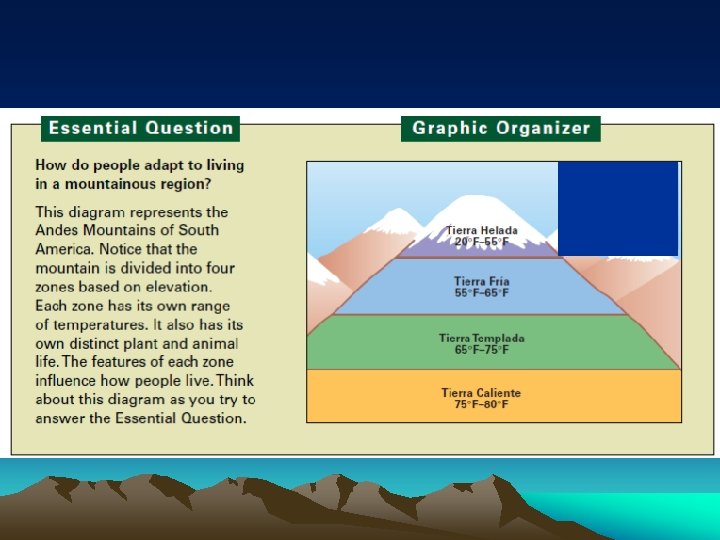
Definitions Altitudinal zonation – the division of land into zones based on elevation Snow line – lowest elevation on mountains where snow remains year-round Terracing – creation of flat areas on mountain slopes for the purpose of farming Vertical trade – trading of crops between highland lowland areas
– Read the section of Chapter 13 that corresponds with your assigned elevation zone. • Record the Elevation range. • Record at least 2 other physical characteristics of that zone. • Record at least 2 human adaptations
GROUPS AND PAGE NUMBERS 13. 6 p. 198 13. 5 p. 196 13. 4 p. 195 13. 3 p. 194 Group 3 Group 2 Group 1
Life in the Central Andes • Part 1 – Read the section of Chapter 13 that corresponds with your assigned elevation zone. • Record the Elevation range. • Record at least 2 other physical characteristics of that zone.
Life in the Central Andes • Part 2 – Find the 3 graphics that show human adaptations in each elevation zone. • Write the letter next to the correct elevation • Write a brief explanation of how or why it has been adapted to that elevation.
Tierra Helada • 13. 6 12, 000 -15, 000 • Extreme environment; cold windy climate; often freezes at night; snow falls at the highest elevations; snow line lies at the upper edge of this zone; trees are rare; the most common plant life are low-lying shrubs and hardy grass
Tierra Fria • 6, 000 -12, 000 • Average temps vary from 55 -65; night temperatures dip below freezing at higher elevations; steep, rugged mountains, flat basins and plateaus lie between the mountains; ah igh plateau, the Altiplano, lies between Peru and Bolivia and contains Lake Titicaca; pines and other conifers grow where is enough rain; only shrubs and grasses grow in dry areas
Tierra Templada • 3, 000 -6, 000 • Climate is temperate; temperature range from 65 -75; frost is rare; pleasant weather lasts all year; palms, bamboo, and jungle vines are common at lower elevations; broadleaf evergreen forest is typical at higher elevations
Tierra Caliente • 0 -3, 000 • Climate is generally hot and humid; average temps range from 75 -80; broadleaf evergreen forests cover the eastern slopes of the Andes; natural vegetation on the western slopes ranges from lush rainforest to tropical grassland; Peru’s coast gets little rainfall and is a desert