JAXA missions and datasets Status update A Rosenqvist

 implemented")


 May")


 characteristics Stripmap (res. 3/6/10 m) ALOS-4 ALOS-2 100 -200 km 30 -70")
 characteristics In. SAR capability between ALOS-2 and ALOS-4 Master/slave of In. SAR")
 • JAXA LIDAR mission to fly on")


 level L 1 L 2 Product category")


 Kahan river delta, North Kalimantan, Indonesia. (Left) Multi-temporal SAR")
 online at www. gfw. org and for public")
- Slides: 22
JAXA missions and datasets Status update A. Rosenqvist, O. Ochiai, T. Tadono, Motohka, M. Hayashi (JAXA) T. SDCG-14 Session 2 Item#6 JRC, Ispra/Italy, Sept 4 -5 2018 1
ALOS-2 • PALSAR-2 operations nominal • Major revision of Basic Observation Scenario (BOS) implemented from Jan 2018 - 10 m dual-pol Fine Beam mode - Observation windows increased (4 6) - Boreal observations in May-Sept period to reduce seasonal impact on backscatter - Increased obs frequency in the tropics - 50 m Scan. SAR - Staggered observations to improve acq. Success rate - Every 42 -day repeat maintained - 6 m Quad-pol - Global observations discontinued focus on Super Sites - 3 m Ultra-Fine - Global observation plan completed
Schedule of ALOS/ALOS-2 Data Processing and Open Free Access 2018 1 Q Jan Mar ALOS AVNIR-2 (10 m) 2 Q Apr Jun Japan Area 3 Q Jul Sept 2019 4 Q Oct Dec ± 60 Degree Area 1 Q Jan Mar 2 Q Apr Jun 3 Q Jul Sept 4 Q Oct Dec Global Data Processing PALSAR (10 m) Under negotiation with METI Japan Area ± 60 Degree Area Data Processing ALOS-2 Scan. SAR (100 m) Under negotiation with PD Fine Mode (10 m) Under negotiation with PD Global
Near-future missions
ALOS series development/operation 2014 2015 2016 2017 2018 2019 2020 2021 ALOS-2 (L-SAR) May 24 Launch Initial C/O Initial Cal-Val Product release Mission operation (5 years) ALOS-3 (Optical) Development ALOS-4 (L-SAR) Development Post-mission operation Launch
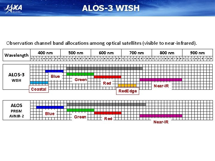
ALOS-3 Items Orbit Specifications Type Sun-synchronous sub-recurrent Altitude 669 km at the equator Local Sun Time 10: 30 am +/- 15 minutes at the descending node Revisit 35 days (Sub-cycle 3 days) Instruments - Wide-swath and high-resolution optical imager (WISH, as a tentative) - Dual-frequencies Infrared sensor (hosted payload) Ground Sampling Distance (GSD) - Panchromatic band of WISH (Pa): 0. 8 m - Multispectral band of WISH (Mu): 3. 2 m (6 bands) Quantization 11 bit / pixel Swath width 70 km at nadir Mission data rate Approx. 4 Gbps (after onboard data compression: 1/4 (Pa) and 1/3 (Mu)) Mission data downlink - Direct Transmission: Ka and X-band - via. the Optical Data Relay Satellite Mass Approx. 3 tons at launch Size 5 m× 16 m× 3. 5 m on orbit Duty 10 mins / recurrent Design life time Over 7 years Wide-swath and high-resolution optical imager (WISH) In-orbit configuration 6
ALOS-3 Observation Modes 1 Strip-map observation The satellite can normally perform observation covering 70 km in width and 4, 000 km in along-track direction as the strip-map observation mode. To increase the acquisition frequency, the images will be taken by less than 25 deg. pointing angle in cross-track direction (GSD < 1 m) when the satellite track is in oceans. 2 Point observation If the user has a certain ground point or an area of interest (AOI), the satellite can observe there using pointing capability within 60 deg. This mode will be used for natural disaster monitoring, for example. 3 Observation direction changing The satellite can observe any given point by the pointing capability up to 60 deg. in all direction against the satellite nadir. In the case of Japan, it can be activated within 24 hours after receiving the request. This will be used when the large natural disaster happens e. g. the expecting Nankai Trough large earthquake. 4 Wide-area observation This mode can cover in wide-ranging area of 200 km (in along-track direction) x 100 km (in cross-track direction) by satellite’s single orbital passage. This will be also used when the large natural disaster happens. 5 Stereoscopic observation Two ways proposes to acquire stereo-pair image: 1) in single orbit path, and 2) combining two strip-map observations by nadir view and backward view in neighboring path after three days (sub-cycle revisit orbit). The way 1) will be however not sufficient base-to-height ratio (B/H) to derive terrain information. As the advantages of the way 2), that is possible to set suitable B/H, and can acquire images over large area. However, this will depend on weather conditions i. e. cloud covers, to success stereo image acquisition within short period as a disadvantage. 1 and 5 will be used in the basic observations. 8
ALOS-4 Mission Objectives 1. Precise monitoring of land deformation and subsidence for detecting anomalies at an early stage 2. Continuation and enhancement of the ALOS-2 mission and also exploring new applications - All-weather disaster monitoring - Forest monitoring - Sea ice monitoring - Large infrastructure monitoring, etc. 3. Marine monitoring with AIS (Automatic Identification System)
ALOS-4 (PALSAR-3) characteristics Stripmap (res. 3/6/10 m) ALOS-4 ALOS-2 100 -200 km 30 -70 km Scan. SAR (res. 25 m*) 700 km 350 -490 km Spotlight (res. 1 x 3 m) 35 km× 35 km 25 km× 25 km *single look Ø Expanded swath width with maintained spatial resolution and image quality of PALSAR-2 by digital beam forming (DBF). Ø To guarantee the continuity of ALOS-2 applications, PALSAR-3 will inherit the major function and performance (NESZ, S/A, etc. ) of PALSAR-2
ALOS-4 (PALSAR-3) characteristics In. SAR capability between ALOS-2 and ALOS-4 Master/slave of In. SAR pair ALOS-2 Stripmap 100/200 km Scan. SAR 700 km Stripmap 50/70 km Scan. SAR 350/490 km Stripmap 100/200 km ○ ○ Scan. SAR 700 km ○ ○ ○ × ALOS-4 ü ALOS-4 reference orbit is the same as ALOS-2 ü Controlling accuracy is within +/- 500 m (= small baseline)
MOLI Multi-footprint Observation LIDAR and Imager (MOLI) • JAXA LIDAR mission to fly on the International Space Station, Japan Experimental Module (ISS-JEM) • Mission Design Review completed May 2017 • Operations foreseen from around 2020
MOLI Overview • • + Envelope 1600 x 640 x 830 MOLI i-SEEP • (IVA-replaceable Small Exposed Experiment Platform) • Schematic diagram of MOLI • • MOLI characteristics Demonstration mission on ISS-JEM ISS Orbit Altitude 400 km, Inclination 51. 6 deg Instruments – Double beam LIDAR • Wavelength: 1064 nm • Pulse width: less than 7 ns • PRF: 150 Hz • Double beam (2 foot prints) – Multiband Imager • Resolution: 5 m • Swath: 1 km • Band: NIR, R, G Canopy measurements – Foot print 25 m diameter – Height accuracy =< 3 m Mission duration; > 1 year Planned Launch year 2020 Using i-SEEP platform, more flexible environment and services by astronauts are expected. Laser Transmitter to be returned (post mission) for degradation evaluation on ground. 13
Foot print design for terrain relief calbaration Ø For calibration of terrain relief: - Staggered double footprints with the same transmitting timing Ø For estimation of ground surface slope angle: - Slope estimation using 3 footprints - Target slope: ≦ 30 deg. No snow cover. 50 m (PRF 150 Hz) Along track 15 m 15 m 25 m in diameter (beam divergence 62. 5 mrad ) (n)th pulse (n+1)th pulse ・・・ 14
MOLI data products Standard Products (quality assured) level L 1 L 2 Product category Products Remark Lidar footprint products Full waveforms including geolocation data Imager product (1 km swath) Image geometrically corrected Canopy heights including geolocation data AGB* including geolocation data Lidar footprint products *: Above Ground Biomass Research Products (quality evaluated) level Product category Products Tree canopy heights L 3 Synergy products with MOLI Lidar and imager (1 km swath) L 4 Synergy products with MOLI and other satellites Wall-to-Wall map products Tree canopy height Map Forest biomass map Remark Line to 2 D expansion “Wall 2 Wall” expansion 15
GFOI Core Data Set – 25 m L-band SAR mosaics and Forest/Non-Forest maps • HH backscatter (gamma-0) 16 bits • HV backscatter (gamma-0) 16 bits • Mask image (no-data, water, layover, shadowing. ) 8 bits • Local incidence angle image, 8 bits BYTE • Observation date image (DN = days after mission launch) 16 bits 16 16 public download at http: //www. eorc. jaxa. jp/ALOS/en/palsar_fnf/fnf_index. htm Open
GFOI Core Data Set – 25 m L-band SAR mosaics and Forest/Non-Forest maps Global coverage • PALSAR-2 2017 (released May 2018) • PALSAR-2 2016 • PALSAR-2 2015 • PALSAR 2007 – 2010 • JERS-1 ~1996 • Free download at: http: //www. eorc. jaxa. jp/AL OS/en/palsar_fnf/fnf_index. htm
GFOI Core Data Set – 25 m L-band SAR mosaics and Forest/Non-Forest maps Regional (pan-tropical) coverage (25 m) • JERS-1: 1996 – 1998 Global low resolution (100 m) coverage • JERS-1: 1996 – 1998 • Free download at: http: //www. eorc. jaxa. jp/ALO S/en/palsar_fnf/fnf_index. ht m
Global Mangrove Watch An international collaborative project established as part of JAXA’s Kyoto & Carbon (K&C) Initiative science programme. Mapping of extent and changes in global mangrove area Thematic Datasets • Global mangrove baseline extent maps for 2010 (PALSAR + Landsat) • Global maps of annual changes in the global mangrove extent – public release 2018/Q 4 • 1996 (JERS-1) • 2007 – 2009 (ALOS PALSAR) • 2015, 2016 & 2017 (ALOS-2 PALSAR-2) 19
Niger river delta, Nigeria 2010 global mangrove baseline Guayaquil, Ecuador Sundarbans, India & Bangladesh 20
Changes over time (7 epochs) Kahan river delta, North Kalimantan, Indonesia. (Left) Multi-temporal SAR composite (1996 JERS-1 SAR and 2016 ALOS-2 PALSAR-2) (Right) Mangrove extent and changes, Red – mangroves lost 1996 -2007, Orange – loss 2007 -2016, Green – mangrove cover in 2016.
Global 2010 baseline (v 2. 0) online at www. gfw. org and for public download at data. unep-wcmc. org/datasets/45