JAXA ALOS and MOLI developmentoperation JFY AprMar 2014
 2014 2015 2016 2017 2018 2019 2020")
 ALOS-4 project team /")


th Pulse (n+1)th Pulse Footprint 25 m φ Calculating ground")


- Slides: 17
JAXA ALOS and MOLI development/operation JFY (Apr-Mar) 2014 2015 2016 2017 2018 2019 2020 2021 2022 2023 2024 2025 2026 2027 ALOS-2 (SAR) Nominal operation (5 years) Post-mission operation ALOS-3 (Optical) Development Nominal operation (7 years) ALOS-4 (SAR) Development Nominal operation (7 years) MOLI (Li. DAR) Nominal operation (2 years) ALOS-3 F/O (Optical) ALOS-4 F/O (SAR)
ALOS-4 status update Takeshi Motohka Japan Aerospace Exploration Agency (JAXA) ALOS-4 project team / EORC ALOS Kyoto & Carbon Initiative meeting Jan. 30, 2018 2
ALOS-4 System characteristics Y Launch JFY 2020 H 3 launch vehicle Orbit Same orbit as ALOS-2 Sun-synchronous sub-recurrent orbit Altitude: 628 km Inclination angle: 97. 9 degree Local sun time at descending: 12: 00 ± 15 min. Revisit time: 14 day (15 -3/14 rev/day) Lifetime 7 years Satellite Mass approx. 3 tons Downlink 3. 6 Gbps/1. 8 Gbps (Ka-band) Mission Instruments - PALSAR-3 (Phased Array type Lband Synthetic Aperture Radar-3) - SPAISE 3 (SPace based AIS Experiment 3) Prime contractor Mitsubishi Electric Corporation X Z Solar array paddle PALSAR-3 antenna Ka-band DT antenna SPAISE 3 antenna
Compatibility with ALOS-2 Stripmap 10 -m mode same orbit, same geometry ALOS-4 observation beams ALOS-2 observation beams 200 km swath 70 km swath x 3 (F 2 -5~7) Incidence angle 28. 4 deg. 42. 6 deg.
Scan. SAR mode same orbit, same geometry ALOS-4 observation beams 700 km swath Incidence angle 19. 5 deg. 26 deg. ALOS-2 observation beams 350 km swath (W 2) 49 deg. 59. 8 deg.
K&C Science Team meeting #24 Tokyo, Japan, January 29 -31, 2018 Advanced Optical Satellite (ALOS-3) Overviews January 30, 2018 Takeo Tadono 1, Hidenori Watarai 1, Ayano Oka 1, Yousei Mizukami 1, Junichi Takaku 2, Fumi Ohgushi 2, and Masanori Doutsu 2 1 JAXA, 2 RESTEC E-mail: tadono. takeo@jaxa. jp
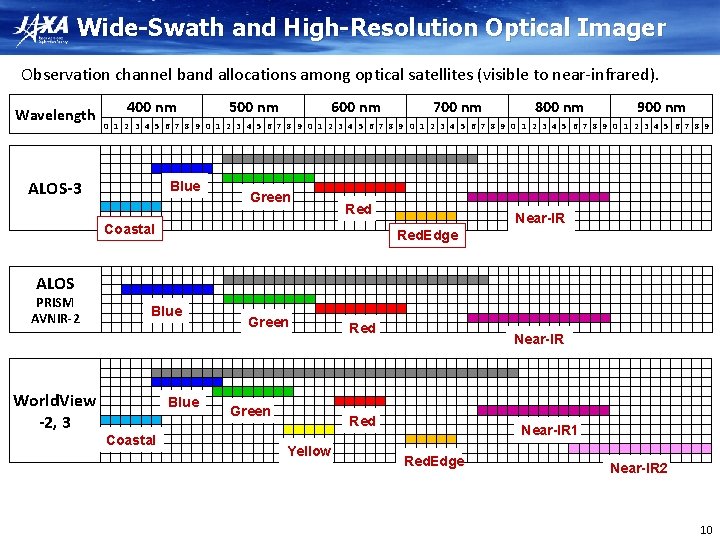
Overview of ALOS-3 Items Orbit Specifications Type Sun-synchronous sub-recurrent Altitude 669 km at the equator Local Sun Time 10: 30 am +/- 15 minutes at the descending node Revisit 35 days (Sub-cycle 3 days) Instruments - Wide-swath and high-resolution optical imager (WISH, as a tentative) - Dual-frequencies Infrared sensor (hosted payload) Ground Sampling Distance (GSD) - Panchromatic band of WISH (Pa): 0. 8 m - Multispectral band of WISH (Mu): 3. 2 m (6 bands) Quantization 11 bit / pixel Swath width 70 km at nadir Mission data rate Approx. 4 Gbps (after onboard data compression: 1/4 (Pa) and 1/3 (Mu)) Mission data downlink - Direct Transmission: Ka and X-band - via. the Optical Data Relay Satellite Mass Approx. 3 tons at launch Size 5 m× 16 m× 3. 5 m on orbit Duty 10 mins / recurrent Design life time Over 7 years Wide-swath and high-resolution optical imager (WISH) In-orbit configuration 9
Observation Modes 1 Strip-map observation The satellite can normally perform observation covering 70 km in width and 4, 000 km in along-track direction as the strip-map observation mode. To increase the acquisition frequency, the images will be taken by less than 25 deg. pointing angle in cross-track direction (GSD < 1 m) when the satellite track is in oceans. 2 Point observation If the user has a certain ground point or an area of interest (AOI), the satellite can observe there using pointing capability within 60 deg. This mode will be used for natural disaster monitoring, for example. 3 Observation direction changing The satellite can observe any given point by the pointing capability up to 60 deg. in all direction against the satellite nadir. In the case of Japan, it can be activated within 24 hours after receiving the request. This will be used when the large natural disaster happens e. g. the expecting Nankai Trough large earthquake. 4 Wide-area observation This mode can cover in wide-ranging area of 200 km (in along-track direction) x 100 km (in cross-track direction) by satellite’s single orbital passage. This will be also used when the large natural disaster happens. 5 Stereoscopic observation Two ways proposes to acquire stereo-pair image: 1) in single orbit path, and 2) combining two strip-map observations by nadir view and backward view in neighboring path after three days (sub-cycle revisit orbit). The way 1) will be however not sufficient base-to-height ratio (B/H) to derive terrain information. As the advantages of the way 2), that is possible to set suitable B/H, and can acquire images over large area. However, this will depend on weather conditions i. e. cloud covers, to success stereo image acquisition within short period as a disadvantage. 1 and 5 will be used in the basic observations. 1, 3 and 5 simulated images are shown. 11
Observation Direction Changing Mode Satellite orbit Observation area The satellite can observe any given point by the pointing capability up to 60 deg. in all direction against the satellite nadir. In the case of Japan, it can be activated within 24 hours after receiving the request. This will be used when the large natural disaster happens e. g. the expecting Nankai Trough large earthquake. 12
Related mission updates: MOLI Masato Hayashi, Tadashi Imai, Daisuke Sakaizawa, Jumpei Murooka, Rei Mitsuhashi, Toshiyoshi Kimura Japan Aerospace Exploration Agency (JAXA) Science Team meeting #24 Tokyo, Japan, January 29 -31, 2018
MOLI will be installed to ISS JEM in 2020.
← Time M ulti-footprint O bservation L idar and I mager Reflectance 反射レーザ Sensor Ø Li. DAR : 2 beams, 25 mφ footprint. Ø Imager : 5. 0 m resolution, 3 bands, 1 km swath. Ø To estimate forest biomass precisely and globally. Objective Ø To obtain spaceborne Li. DAR technology for future missions.
50 m 15 m (n)th Pulse (n+1)th Pulse Footprint 25 m φ Calculating ground elevation and slope. Multi-footprint observation.
MOLI products.
One month day year 51. 6°N year One month 51. 6°S 3. 5 km distance in average MOLI observation area (ISS orbit).
Summary p MOLI will be installed to ISS in 2020. p It can provide precise values of canopy height and forest biomass, globally. p We will also provide forest biomass map created by combining with the other satellite image (e. g. , PALSAR 2, 4). p We expect that MOLI will make significant contribution to carbon-cycle study and climate change measures.