Hydrologic Design of a Percolation Tank C P


,")


 Total height of embankment, H Top width of embankment = (5/100)")

")


- Slides: 25
Hydrologic Design of a Percolation Tank C. P. Kumar, Scientist ‘F’ National Institute of Hydrology Roorkee (India)
ARTIFICIAL RECHARGE The artificial recharge to ground water aims at augmentation of ground water reservoir by modifying the natural movement of surface water. Any man made scheme or facility that adds water to an aquifer may be considered to be an artificial recharge system. Artificial recharge techniques normally address to the following issues: 1. To enhance the sustainable yield in areas where over-development has depleted the aquifer. 2. Conservation and storage of excess surface water for future requirements, since these requirements often change within a season or a period. 3. To improve the quality of existing ground water through dilution. 4. The basic purpose of artificial recharge of ground water is to restore supplies from aquifers depleted due to excessive ground water development. Desaturated aquifer offers good scope in locations where source water, if available, can be stored using artificial recharge techniques.
BASIC REQUIREMENTS The basic requirements for recharging the ground water reservoir are: 1. Availability of non-committed surplus monsoon run off in space and time. 2. Identification of suitable hydrogeological environment and sites for creating subsurface reservoir through cost effective artificial recharge techniques.
ARTIFICIAL RECHARGE STRUCTURES A wide spectrum of techniques are being implemented to recharge the ground water reservoir. The artificial recharge structures, which are feasible in varied hydrogeological situation, are: 1. PERCOLATION TANKS 2. CHECK DAM/ NALA BUND 3. GABION STRUCTURE 4. MODIFICATION OF VILLAGE TANKS AS RECHARGE STRUCTURE 5. DUG WELL RECHARGE 6. RECHARGE SHAFTS 7. INJECTION WELL 8. GROUND WATER DAMS OR SUB SURFACE DYKES OR UNDERGROUND BANDHARAS 9. ROOF TOP RAIN WATER HARVESTING
PERCOLATION TANKS • The percolation tanks are mostly earthen dams with masonry structure only for spillway. These are the most prevalent structures in India as a measure to recharge the groundwater reservoir both in alluvial as well as hard rock formations. • Percolation tank is an artificially created surface water body, submerging in its reservoir a highly permeable land so that surface runoff is made to percolate and recharge the ground water storage. • Percolation tank should be constructed preferably on second to third order streams, located on highly fractured and weathered rocks, which have lateral continuity downstream. • Percolation tank should be located on highly fractured and weathered rock for speedy recharge. In case of alluvium, the bouldary formations are ideal for locating percolation tanks. • The aquifer to be recharged should have sufficient thickness of permeable vadose zone to accommodate recharge.
• The downstream of recharge area should have sufficient number of wells and cultivable land to get benefit from the augmented ground water. • In Peninsular India with semi arid climate, the storage capacity of percolation tank should be designed such that the water percolates to ground water reservoir by January/February, since the evaporation losses would be high subsequently. • The size of a percolation tank should be governed by the percolation capacity of the strata in the tank bed rather than yield of the catchment. In case, the percolation rate is not adequate, the impounded water is locked up and wasted more through evaporation losses, thus depriving the downstream area from the valuable water resource. • Detailed analysis of the rainfall pattern, number of rainy days, dry spells, evaporation rate and detailed hydrogeological studies are necessary to demarcate suitable percolation tank sites. • Detailed hydrological studies should be done for runoff assessment and designed capacity should normally not be more than 50 percent of the total quantum of utilizable runoff from the catchment.
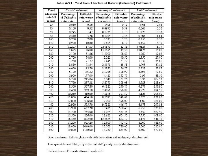
DESIGN OF PERCOLATION TANK Capacity of the percolation tank has to be calculated on the basis of the rainfall and catchment area of the tank. Also the weir length (surplus weir) has to be calculated. The procedure is as follows: 1. Select the site for the percolation tank. 2. From the toposheet, find out the correct catchment area of the watershed at that location. 3. Compute catchment yield from rainfall and runoff coefficient or Strange's table (using monsoon rainfall; nature of catchment - good, average or bad; and catchment area).
4. Make suitable assumptions - such as number of fillings per year (say 2), utilization of yield per filling (say 5%) etc. Compute capacity of percolation tank (based-upon utilization of yield per filling). 5. Development of stage-capacity curve/table: Draw the contour lines at every 50 cm interval between the bed level and the highest ground level at the site. From these contour lines, the capacity of the tank at 0. 5 m, 1. 0 m, 1. 5 m, 2. 0 m, …. height above the bed level is calculated. 6. Compute full tank level (FTL) from stage-capacity curve/table.
Embankment
7. Make allowances for free board and settlement. Free Board F = 1. 5 hw = free board in m hw = 0. 014 (Dm )0. 5 = wave height in m Dm = fetch length (the longest exposed water surface on the reservoir) in m Settlement Ø Depends upon the type of fill material and the method and speed of construction. Ø Varies from 10% of design height for hand compacted (normally constructed) fill to 5% for machine compacted (rolled at optimum moisture) fill.
8. Compute top width of embankment. W = H/5 + 1. 5 W = top width of embankment (m); H = total height of embankment (m). 9. Compute length of embankment. Length of the embankment is the distance between the points where the height intersects the contour having same elevation.
10. Based-upon the type of material, assign suitable side slopes for embankments.
11. Compute peak discharge depending upon the catchment area and type of corresponding data available. Rational method: Q = CIA/36 Q = peak discharge, m 3/s; C = runoff coefficient; I = Intensity of rainfall for duration equal to the time of concentration of the watershed, cm/hr; A = catchment area of the watershed, ha. Dicken’s formula: Q = CA 3/4 Q = peak discharge, m 3/s; A = catchment area in km 2; C = constant (for North India, C = 11. 5; Central India, C = 14 to 19. 5; Western India, C = 22 to 25). The formula is generally useful for catchments of North India. An average value of C equal to 11. 5 is generally used and it is increased for hilly catchments and vice versa. Ryve’s formula: Q = CA 2/3 Q = peak discharge, m 3/s; A = catchment area in km 2; C = constant (for areas within 80 km from coast, C = 6. 8; areas within 80 -2400 km from coast, C = 8. 8; areas near hills, C = 10. 1; actual observed values, C upto 40). The formula is applicable to catchments in South India. The average value of C to be used is 6. 8 with less value for flat catchments and more for hilly catchments.
12. Compute length of spillway using peak discharge. For small tanks, the height of flow over weir is taken between 0. 30 m 0. 60 m and this level is known as maximum water level (MWL). To decide the length of the surplus weir Q = CLh 3/2 L = Q/Ch 3/2 C = Constant =1. 67 (for broad crested weir) L = Length of the weir (m) h = Flow height over the weir (m)
13. Compute width of horizontal floor. Ø The width of horizontal floor of masonry weirs with vertical drop, from the foot of the drop wall to the downstream edge of the floor should not be less than 2(D+H), where D is the height of the drop wall and H is the maximum head of water over the wall. Ø The rough stone apron forming a talus below the last wall may be taken from 2. 5(D+H) to 5(D+H) depending upon the nature of the soil and the velocity. 14. Check the stability of the structure by locating the saturation line on the base.
Design Example of Earthen Embankment for Percolation Tank
Design an earthen embankment using the following data: Catchment area = 21 ha Intensity of rainfall = 17 cm/hr RL of ground surface = 100 m RL of HFL = 103. 00 m Runoff coefficient C = 0. 3 Soil type is sandy loam Slope of saturation line = 4: 1 Assume a fetch of 500 m
Hints Ø Compute height of water upto HFL. Ø Compute height of waves. Ø Compute free board. Ø Compute allowance for settlement. Ø Assign upstream and downstream slopes from table. Ø Compute peak discharge. Ø Compute length of spillway (assume head over spillway crest = 0. 3 m). Ø Compute width of horizontal floor. Ø Locate the saturation line for checking stability.
Solution Height of water upto HFL = 103. 00 – 100. 00 = 3. 00 m Height of waves, hw = 0. 014 (Dm )0. 5 = 0. 014 * 5000. 5 = 0. 31 m = 1. 5 hw = 1. 5 * 0. 31 = 0. 46 m = 3. 00 + 0. 46 = 3. 46 m Freeboard, F Height of embankment
Consolidation (5 %) Total height of embankment, H Top width of embankment = (5/100) * 3. 46 = 0. 17 m = 3. 46 + 0. 17 = 3. 63 m = H/5 + 1. 5 = 3. 63/5 + 1. 5 = 2. 23 m
Using the respective table, adopt the following side slopes of embankment for sandy loam – Upstream slope = 3 Downstream slope = 2. 5 : 1 = C I A / 36 = 0. 3 * 17 * 21 / 36 = 2. 975 m 3/s = Q / (C h 3/2 ) = 2. 975 / (1. 67 * 0. 33/2 ), Peak discharge, Q Length of spillway, L : 1 (assuming head over spillway crest, h as 0. 3 m) = 10. 84 m
Width of horizontal masonry floor, W 1 = = = 2 (D + H) 2 (3. 00 + 0. 3) 6. 60 m Width of rough stone talus, W 2 = = = 4 (D + H) 4 (3. 00 + 0. 3) 13. 20 m
2. 23 m HFL 3. 63 m 22. 20 m Actual length required for saturation line to be in the base of embankment = 3*4+3*3 = 21 m Length available for saturation line to be in the base of embankment = 3. 63 * 2. 5 + 2. 23 + 3. 63 * 3 = 22. 20 m The saturation line meets the base of embankment, therefore the section is stable.