Groundwater Freshwater 3 of total Earth water Glaciers


 Open to the surface, but confined at greater depth by")


 COUNTRY Share of demand * Total use Non-renewable")


- Slides: 46
Groundwater
Freshwater 3% of total Earth water Glaciers Atmosphere Groundwater Lakes Soils Rivers Wetlands
Aquifers/Groundwater 0. 6% of total earth water. 98% of all readily available freshwater Supplies ½ of the drinking water in U. S. and 90% of the drinking water in FL.
Aquifers Aqua – water Ferre – to carry Water-bearing formation that can store and release usable amounts of water.
Where is Groundwater? Water found in pore spaces, seams cracks, and fractures in geologic material or soils beneath the surface of the earth Water-bearing Unit materials Sands Silts Gravels Muds Clays Rock
Aquifers and Aquifer Types
Aquifer Classification Consolidated Unconsolidated Confined Unconfined
Basic Aquifer Classification Unconsolidated or Consolidated Unconsolidated: granular sand, gravel, clays, silts Water held in pore spaces between grains of sand, gravel, clays, or rock fragments Consolidated: sandstone, limestone, granite Water held in cracks, fissures and seams in solid rock formations.
Unconsolidated Aquifers
Unconsolidated sands and gravel Water-Bearing Unit
Unconsolidated: sand gravel saturated thickness ranges from a few feet to more than 1000 feet thick 174, 000 mi² High Plains Aquifer thin
Semi-arid Region 20% of U. S. grain production 27 percent of the irrigated land in the United States overlies this aquifer yields about 30 percent of the nation's ground water used for irrigation provides drinking water to 82 percent of the people who live within the aquifer boundary
Consolidated Aquifers
Water-Bearing Unit Consolidated Rock: igneous or sedimentary
Consolidated Aquifers Igneous Rocks formed from the cooling and solidification of molten magma originating in the earth's core Extrusive rock is formed when the solidification process occurs at or near the ground surface. These rocks are generally very permeable because of the "bubbling" of gases escaping during cooling and solidification. horizontal fracturing Granite The Columbia River Plateau covering eastern Washington and Oregon, and Idaho, averages about 500 m in thickness and is one of the largest basalt deposits in the world. Basalt aquifers are critically important water sources for the Hawaiian Islands.
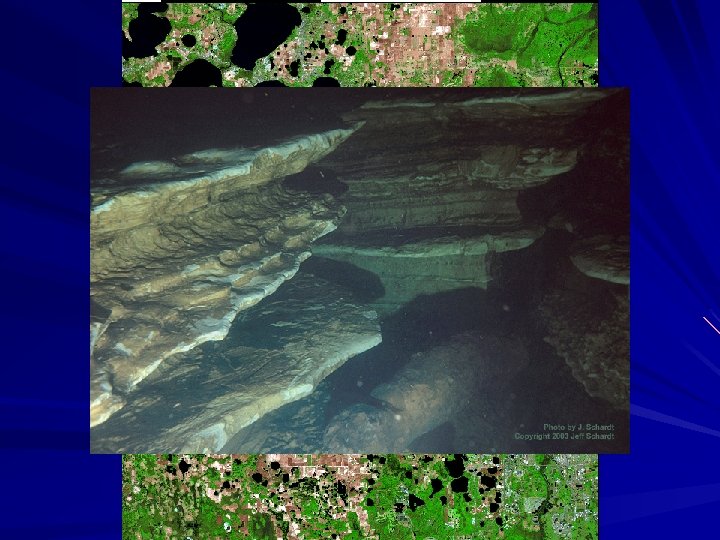
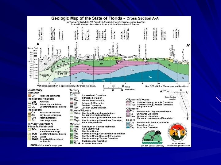
Consolidated Rock Aquifers Sedimentary Sandstone and Carbonate Sandstone is a cemented form of sand gravel St. Peter Sandstone in northeastern Illinois covers more than 290, 000 mi 2 and averages 80 to 160 ft in thickness Carbonate formations include limestone (Ca. CO 3) and dolomite Exhibit mostly secondary porosity due to fracturing and dissolution openings
Consolidated Aquifers: Guaraní Aquifer Sedimented sandstones deposited during the Triassic and Jurassic periods Thickness: 50 m to 800 m 37, 000 km³ of water 5% of world population fresh drinking water for 200 years overlaid with igneous basalt with low-permeability Slowly Recharged (166 km³/year) Argentina, Brazil, Paraguay and Uruguay
Confined and Unconfined Aquifers
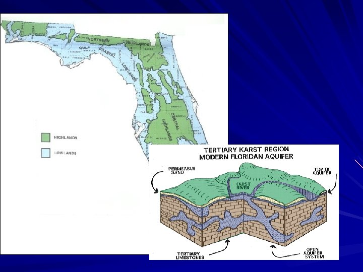
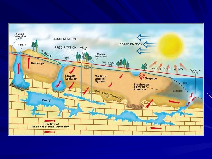
Unconfined Aquifer Water Open to the surface, but confined at greater depth by low-permeability material Low permeability – slow water Groundwater table High Permeability Saturated Zone Low Permeability Geologic or Soil material Saturated Zone thickness dependent on rainfall
Unconfined or Surficial Aquifer
Confined Aquifers A generally inclined, water-bearing formation located between impermeable layers of clay, rock, or shale.
Water-bearing unit is confined between two layers of material that are not permeable to water (confining units). Confining units (aquicludes) Water-bearing unit (consolidated or unconsolidated)
Confined Aquifers Recharge Flow Water-bearing unit Impermeable material High Pressure
Confined and Unconfined Recharge Water-bearing unit impe Wat rmea ble er-b impermeable eari ng u nit
Unconfined aquifer (surficial aquifer) Open to the surface, but confined at greater depth by low-permeability material Recharge is generally by rainfall and surface water bodies Confined aquifer Water-bearing unit is confined between two layers of material that are not permeable to water (confining units). Recharge is in areas where the upper confining unit is thin or absent Water-bearing units: sands, gravel, silts, clays, porous or fractured rock
Recharge, Usage, and Water Mining
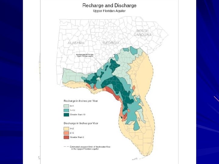
Aquifer Recharge: precipitation surface water runoff Lakes Streams Rivers Wetlands Sinkholes
Non-Renewable Groundwater Resources
Non-Renewable Groundwater Resources Groundwater resources are never strictly non-renewable. Climate Changes Time for Replenishment In cases where present-day aquifer replenishment is very limited but aquifer storage is very large, the groundwater resource can be termed non-renewable
“Fossil” Aquifers Non-renewable aquifers are often described as “fossil” aquifers. These are aquifers with no appreciable modern recharge. Groundwater is isolated from modern recharge Contemporary climate does not support sufficient recharge Most often found in arid climates, fossil and other non-renewable Aquifers are an important water resource for many nations. Nubian Sandstone aquifer underlying Chad, Egypt Libya and Sudan. Qa-Disi aquifer between Jordan and Saudi Arabia Great Artesian Basin of Australia
formed between 100 and 250 million years ago Formed 145. 5 to 65. 5 million years ago Average rainfall < 5 mm/year Closed water system • Age of most water > 20, 000 years,
Settings associated with non-renewable groundwater hyper-arid area with average rainfall of less than 4 in/yr and prolonged dry periods–bulk of aquifer contains fossil groundwater, which infiltrated during humid period s at least 10, 000 years or more ago and still has an active residual flow to a perennial discharge area.
No recharge temperate humid region with annual rainfall in excess of 1, 000 mm/yr normally generating renewable groundwater resources, but highly-confined portion of aquifer system contains essentially non-renewable groundwater as a result of geological structure and geomorphological history – and this is potentially of local strategic importance.
Non-renewable aquifers are often Associated with Water Mining Extensive exploitation of renewable and non-renewable aquifers Withdrawals exceed recharge creating deficits in the aquifer The world water deficit is concentrated in China, the Indian subcontinent, the Middle East, North Africa, and North America
China India Iran Israel Countries currently Withdrawing more Groundwater than Is replenished. Jordan Mexico Morocco Pakistan Saudi Arabia South Korea Spain Syria Tunisia United States Yemen
The Middle East GROUNDWATER (Mm 3/a) COUNTRY Share of demand * Total use Non-renewable Algeria 54% 2, 600 1, 680 Saudi Arabia 85% 21, 000 17, 800 Bahrain 63% 258 90 Egypt 7% 4, 850 900 UAE 70% 900 1, 570 Jordan 39% 486 170 Libya 95% 4, 280 3, 014 Oman 89% 1, 644 240 Qatar 53% 185 150 Tunisia 59% 1, 670 460 Yemen 62% 2, 200 700 *percentage of total use provided by groundwater Saudi Arabia and Libya, use 77% of the estimated total world extraction of non-renewable groundwater for urban supply and irrigated agriculture.
End Lecture 16
Sea Levels Temporary reestablishment of carbonate deposition
Vulnerability One gallon of gasoline can contaminate 1 million gallons of drinking water 1 ppm
Metals Nutrients Pesticides Petroleum Solvents