River Systems Physical Geography The Hydrologic Cycle Infiltration


 some sediment. • Force of gravity tends to")


 System Can be divided into 3 main parts Transport")


- Slides: 54
River Systems Physical Geography
The Hydrologic Cycle • Infiltration = Groundwater System • Runoff = Surface Water System – Runoff = Precipitation Evapotranspiration This is a solar powered system which will continue to recycle water molecules as long as the Sun shines on the Earth. Since (1) everything is connected on this Earth and (2) everything goes somewhere (3) nature knows best, and (4) there are consequences for any alteration of the conditions of the system. Human actions have consequences. Humans can choose to work with nature with minimal disturbance of the natural systems or humans can try to alter conditions and disrupt the natural systems. Human decisions should be carefully thought out before action is taken. Try to anticipate consequences before taking action.
Where is the Water ?
RIVERS & STREAMS • Water Reservoirs • The Hydrologic Cycle • Surface Water Systems • Meandering • Deltas/Alluvial Fans • Floods and flooding If you haven’t been to the Hoover Dam on the Colorado River, you should do that – it is spectacular – breathtaking.
Importance of rivers • Rivers: • • • Provide water and nutrients for agriculture Provide habitat to diverse flora and fauna Provide routes for commerce Provide recreation Provide electricity
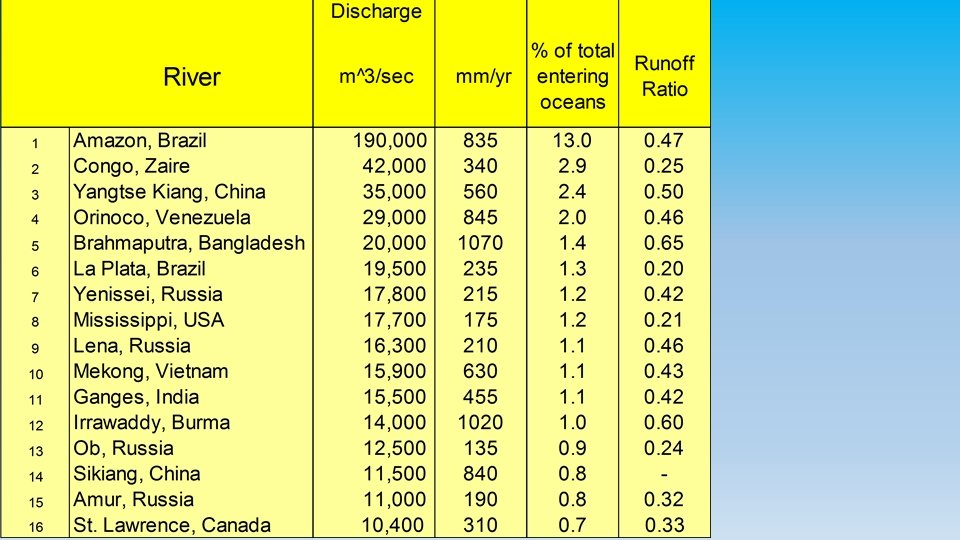
Natural Watercourses: Measurements • Discharge- volume of water • #1 is the Amazon River • Velocity- rate of water movement • Gradient- slope of inclined surface • The steeper the slope, the greater the velocity • More down cutting than side cutting • The more gradual the slope, the slower the velocity. • More side cutting and less down cutting.
Variation in time and space • The shape, size and content of a river are constantly changing, forming a close and mutual interdependence between the river and the land it traverses.
What is a Watershed? www. dec. state. ny. us/website/2000/watersheds. gif A drainage basin is any area of land where precipitation collects and drains off into a common outlet, such as into a river, bay, or other body of water.
The Worlds Largest Rivers 1. Nile 2. Amazon 3. Mississippi-Missouri 4. Yangtze 5. Ob
U. S. Precipitation Map Notice the effect of the Rocky Mountains U. S. Runoff Map
Laminar vs. Turbulent Flow
Near-Laminar flow in the center of a river channel Turbulent flow in the headwaters of a rushing mountain stream
So Where Does The Stream Move Fastest? • Headwaters move slowest • Mouth of stream moves fastest • Laminar flow is more efficient than turbulent flow. • Deeper stream move faster than shallow streams
Sediment Load: all streams carry (transport) some sediment. • Force of gravity tends to work to produce inert particles. • The volume and velocity of the stream overcomes inertia most easily with the smallest particles. The heavier the particles, the more the effect of gravity causes them to move toward being inert • As the velocity of a stream begins to slow down, sedimentation of the stream bed increases
Movement of Bedload by Saltation
Sedimentation
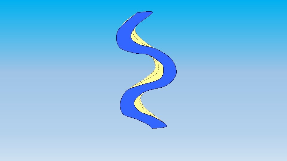
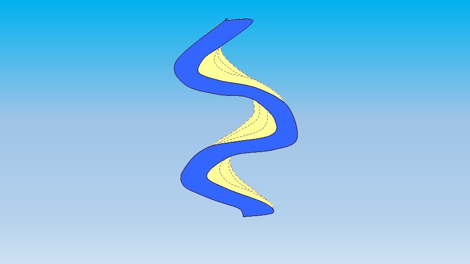
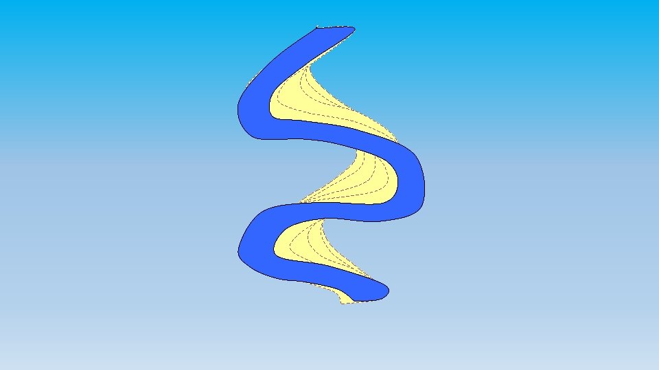
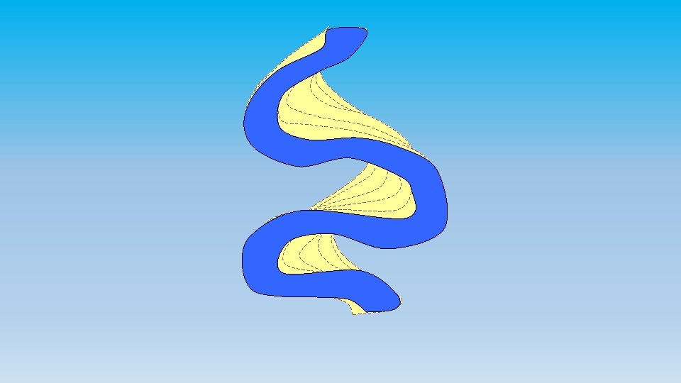
Longitudinal Stream Profile Drainage (Tributary) System Can be divided into 3 main parts Transport System Distributary System
Drainage System • Stream energy is spent eroding downward into the basement rock and. . . • Moving sediment • Creates “V” shaped canyon and valleys • When streams emerge from the mountain front, they often deposit some of this sediment forming alluvial fans. • A move from greater slope to lesser slope • A shift from higher velocity to lower velocity • The effect of gravity on the stream load (of sediment) increases
Alluvial Fans A shift from erosion and transportation to deposition Common feature where mountains descend to arid plains
Aging Rivers: How Old Is It? • Young- rapid bed erosion, waterfalls, rapids, v-shaped valleys, few tributaries, low volume • Mature- well established tributaries, larger volume of water, erode banks and not the bed (bottom), meanders, oxbow lakes
Flash Flooding & Sheetwash
Braided Pattern = moderate slope + high stream power + coarse bed materials
Braided Streams & Rivers • High sediment load • Constantly changing course • Floodplain is completely occupied by channels • Many small islands called mid-channel bars • Usually coarse sand gravel deposits.
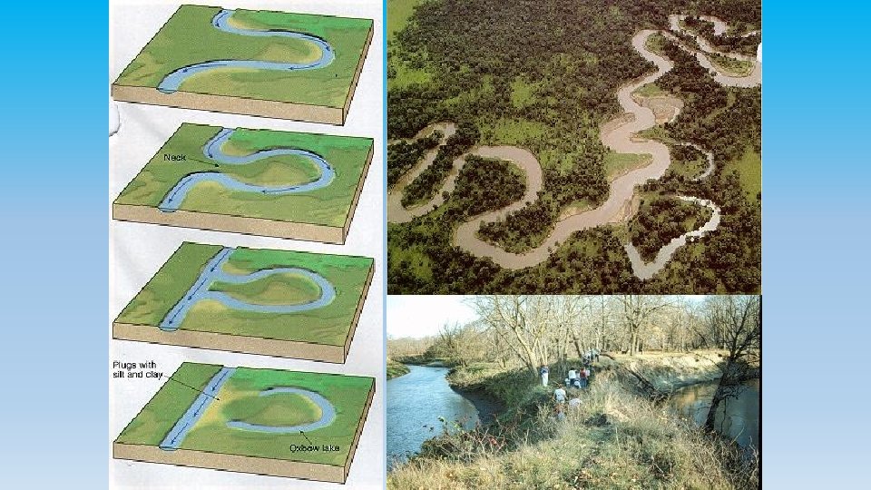
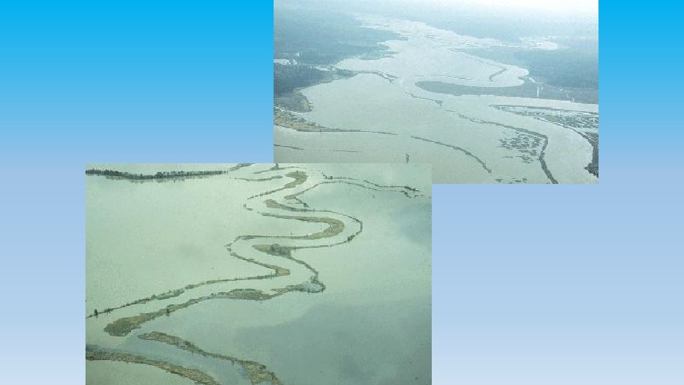
Meandering Rivers
Meandering Rivers • Constantly erode material - Cut bank • Constantly deposit material - Point bar • Change their channel course gradually • Create floodplains wider than the channel • Very Fertile soil • Subjected to seasonal flooding
Formation of Meanders
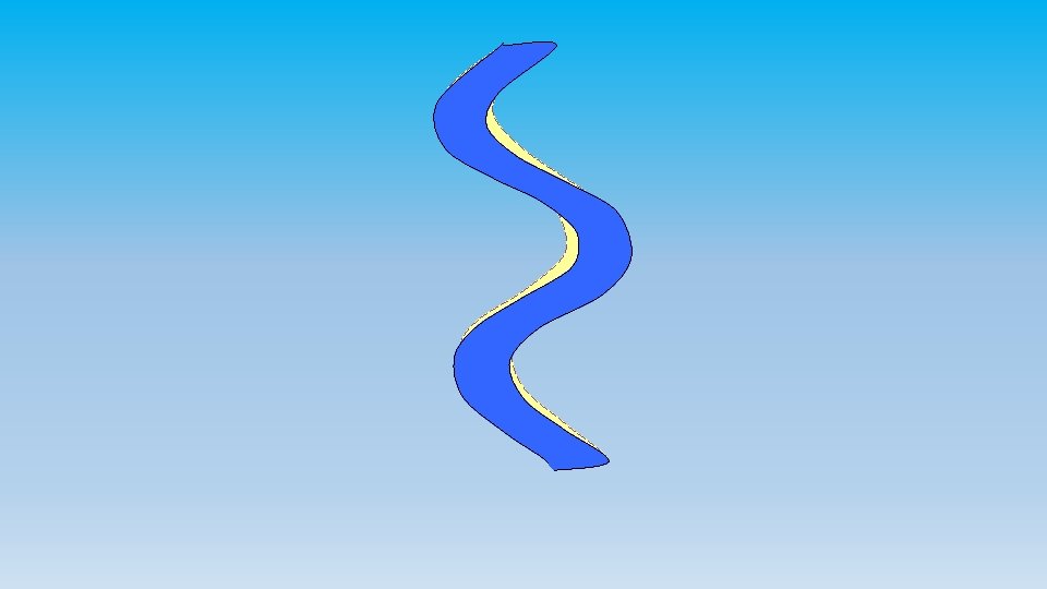
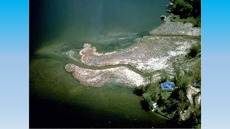
Point bar deposits
Point Bar Deposits Point bar deposits grows laterally through time
Cut bank erosion Point bar deposits } Meander loop
Formation of an Oxbow
Meandering stream flowing from top of screen to bottom
Maximum deposition Maximum erosion
Meander scars Oxbow Lake Oxbow cuttoff
1993 Mississippi Flood
Flooding & Sedimentation
Deltas - Distribution Systems Tributaries: smaller streams that feed into larger streams. Example: The Illinois River is a tributary of the Mississippi River. Distributaries: a stream that branches off and flows away from a main stream channel. They are a common feature of river deltas The phenomenon is known as river bifurcation (dividing up). The opposite of a distributary is a tributary.
If the Mississippi changes course again, what will happen to the City of New Orleans?
What could the 1993 flood teach us? • The Earth City levies held and protected the development there. • Because flood water couldn’t spill into that area, more water was pushed across the river and parts of St. Charles county were flooded which might not have been flooded if the Earth City levies hadn’t been built. • Levies don’t always hold, but when they do, they just create worse conditions for other areas and the people who live and work there. • Floodplains should not be intensively developed-they’re called floodplains for a reason! The best uses are farming and wildlife reserves and simple parks with a minimum of buildings. The flood damage costs would be very low and the land could be back in shape shortly.
Man-made levies • Man-made levies may temporarily protect a portion of the flood plain; however, they just push more water to the other side of the river and the flood extends furthere than it would have, or they cause floodwater downstream to be higher (creating problems for the people there) Remember Chesterfield Valley in 1993? Their levy failed and the whole developed floodplain was flooded. Then businesses foolishly rebuilt in the valley after the levy was sufficiently repaired (they hope).
Things to Remember • Ground water isn’t stationary and lakes and streams are where ground water levels are higher than that area of land. • Rivers are part of a larger hydrologic system • The have three main components: • Drainage (Tributary) systems - collect water • Transport Systems - move water along • Alluvial fans, braided streams, meandering streams • Distributary systems - return water to the sea • Deltas. • Rivers exceed their capacity during floods • Floodplains should not be intensively developed.