Surface Water and Groundwater Running Water and Groundwater


 • The Earth’s water cycle is balanced • Earth’s annual")

 2. Shape")


 is dependent")


")


")


- Slides: 50
Surface Water and Groundwater
Running Water and Groundwater • % of where the Earth’s water is located – Oceans (salt water) – 97 % – Freshwater trapped in Glaciers/ice – 2 % – Freshwater available to us - < 1 % • Water cycle - the continuous circulation of earth’s water supply – Powered by the sun
Elements of the Water Cycle • Evaporation = liquid to gas • Condensation = gas to liquid (forms clouds) • Precipitation = water returns to earth (rain, snow, ice, sleet, etc. ) • Infiltration = water that soaks into ground • Runoff = water that flows across the ground • Transpiration = water that plants release into the atmosphere (gas to liquid)
Water Cycle
Water Cycle (cont. ) • The Earth’s water cycle is balanced • Earth’s annual precipitation = the amount that evaporates • Local imbalances do exist like droughts and floods
Stream Flow • Velocity – distance water travels in a period of time – Some are slow, some are fast – Highest velocities are in the middle of the channel when it is straight – When it bends, the velocity is highest in the outside bank/bend – Ability of a stream to erode & transport materials depends on velocity
5 Stream Velocity Factors 1. Gradient = slope (how steep or flat) 2. Shape = crooked vs straight 3. Size = wide vs narrow & deep vs shallow 4. Roughness = smooth vs rough 5. Discharge = the volume of water flowing past a certain point per unit of time (m 3/s)
Stream Profile • Cross sectional view of a stream • Page 160
Stream Profile Changes • Decrease as you go downstream – Gradient – Roughness • Increase as you go downstream – Discharge – Velocity – Depth – Width • The ability of a stream to erode increases as the discharge increases.
French Broad River Headwaters West Fork, French Broad River North Fork, French Broad River
French Broad Decreasing Gradient Going Downstream Middle French Broad Lower French Broad
Stream Terms • Channel – where the main flow of the river is found • Bank – the side of the river
Stream Terms • Tributary – anything that empties into another stream • Base level – the lowest point to which a stream can erode its channel • Meander – bends/curves in a river/stream • Oxbow lake – a meander that gets cut off from the main stream and form a small lake.
Meanders and Oxbow Lake
Stream Erosion • The ability of stream to carry a load (sediment) is dependent upon 2 factors: – Competence - the largest particles the stream is transporting – Capacity – the maximum load it can carry
Sediment Transportation • 3 types 1. Dissolved Load – sediment that is dissolved in the stream/river q Usually comes from groundwater 2. Suspended Load – the visible cloud of sediment a stream carries q Where a stream carries most of its load 3. Bed Load – sediments that are too large to be carried in suspension q Move along the stream/river bed
Stream Deposition • As the stream slows down material begins to settle out • Larger materials settle out first • Levee – accumulation of sediment along the river banks
Stream Deposition • Delta – a triangular accumulation of sediment formed where a stream enters a lake/ocean
Stream Depostion • Alluvial Fan – forms when a stream slows at the mouth of a mountain canyon
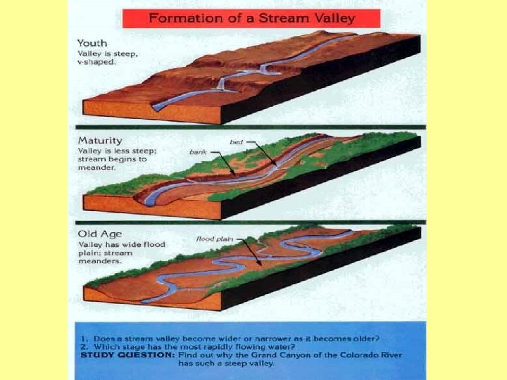
3 Stages of Stream Development 1. Young 2. Mature 3. Old
Young Rivers fast straight narrow rapids v-shaped valleys
Mature Rivers slower meanders wider
Old Rivers slowest meanders and oxbows widest
Flooding • Flood plain – flat areas along rivers that occasionally flood – Where sand rocks are deposited on the side of the river • Things that increase flooding: – Paving – Excess precipitation – Vegetation Removal • Methods of flood control – Dams and levees – Limiting development
Ohio River Flooding
• Drainage basin - the land area that contributes water to a stream • Divide – imaginary line that separates one drainage basin of one stream from another
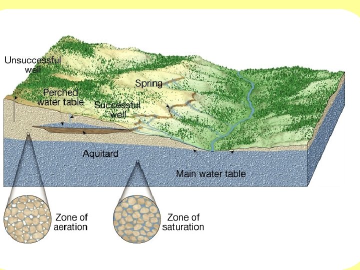
Groundwater • Zone of saturation – area below ground where all the pore spaces are completely filled with water • Zone of aeration – all the pore spaces are not completely filled with water • Water table – the line that divides the two
Groundwater • Porosity – the percentage of the total volume of rock (or sediment) that consists of pore spaces • Permeability – how well water moves through the rock/sediment – Well rounded and well sorted grains = high porosity • Aquifer – rock layers or sediment that allow groundwater to flow freely (sandstone)
Groundwater • Springs – form whenever the water table intersects the surface of the ground • Hot springs – water is heated from magma just below the surface • Geysers – intermittent hot spring/fountain that periodically erupts (Old Faithful)
Groundwater • Wells – a hole bored into the zone of saturation – A pump is needed – Cone of depression • Artesian wells – groundwater rises on its own under pressure and no pump is needed
Wastewater Treatment • https: //www. youtube. com/watch? v=xvid. RVA 9 Tg
Groundwater Environmental Problems • Overuse and contamination threatens groundwater supplies in some areas • Contamination • • • Fertilizers Pesticides Highway salts Chemicals Industrial wastes • Causes land subsidence with too much withdrawal
Land Subsidence
Groundwater Contamination
Caverns • A naturally formed underground chamber • Usually forms in limestone from carbonic acid dissolving the rock • Dripstones – Travertine – Calcium carbonate deposits – Stalactites – form from the ceiling – Stalagmite – form on the floor and reach toward the ceiling
Stalactites and Stalagmites
Karst Topography • limestone areas with many caves and sinkholes (collapsed caves)
Sinkholes
Glaciers
Glaciers • 10% of the Earth is covered in glaciers • Thick mass of ice that forms on land over hundreds or thousands of years
Glaciers • Act like bulldozers while they move – Move rocks and sediments with them and keep them with them until they melt • Iceberg – a mass of ice floating the water – A piece of a glacier that has broken off – Only about 10% of it is above water
Erosion by Glaciers • 5 types 1. 2. 3. 4. 5. 6. Glacial trough Hanging valley Cirque Arete Horn Striations
Glacial Trough • A “V-shaped” valley that has been eroded into a “U-shaped” valley
Hanging Valley • Valleys that are higher than the main glacial trough
Crique • Bowl-shaped depression at the head of a glacial valley – Surrounded on 3 sides by steep rock walls
Arete • Sharp edged ridges left by glaciers
Horn • Sharp pyramid shaped peaks left by glaciers
Glacial Striations • Groves left in the rock when the glacier melts