FCAC CACOF FORO DEL CLIMA DE AMERICA CENTRAL

- Slides: 24
FCAC (CACOF) FORO DEL CLIMA DE AMERICA CENTRAL Meteorological drought forecasting Inter-COF collaboration with Central America Cedric J. VAN MEERBEECK 1, Simon J. Mason 2, Berny Fallas 3 and Patricia Ramirez 4 1 The Caribbean Institute for Meteorology and Hydrology (CIMH), 2 International Research Institute for Climate and Society (IRI), 3 Instituto Costarricense de Electricidad (ICE), 4 Comité Regional de Recursos Hidráulicos (CRRH) Cari. COF Seasonal Forecast Training, May 26 -27, Kingston, Jamaica
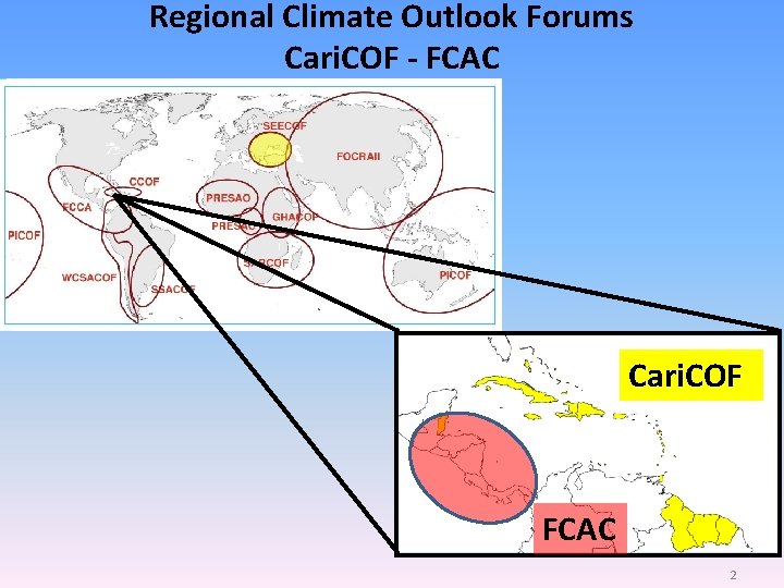
Regional Climate Outlook Forums Cari. COF - FCAC Cari. COF FCAC 2
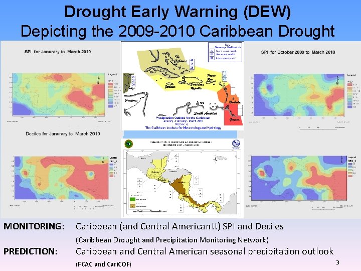
Drought Early Warning (DEW) Depicting the 2009 -2010 Caribbean Drought MONITORING: Caribbean (and Central American!!) SPI and Deciles (Caribbean Drought and Precipitation Monitoring Network) PREDICTION: Caribbean and Central American seasonal precipitation outlook (FCAC and Cari. COF) 3
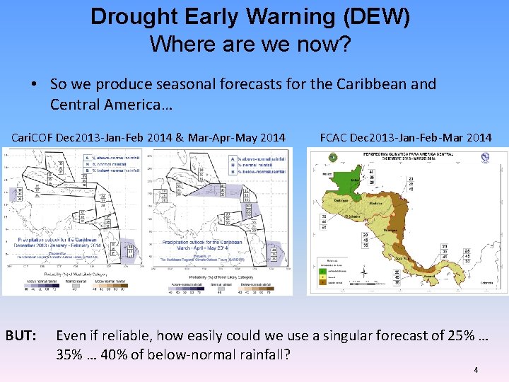
Drought Early Warning (DEW) Where are we now? • So we produce seasonal forecasts for the Caribbean and Central America… Cari. COF Dec 2013 -Jan-Feb 2014 & Mar-Apr-May 2014 BUT: FCAC Dec 2013 -Jan-Feb-Mar 2014 Even if reliable, how easily could we use a singular forecast of 25% … 35% … 40% of below-normal rainfall? 4
Drought Early Warning (DEW) Where do we want to go? BUT: Even if reliable, how easily could we use a singular forecast of 25% … 35% … 40% of below-normal rainfall? • What kind of drought forecasts best inform DEW? – – – Reliable = forecast probabilities correspond well with observed frequencies Timely Understandable language Salient = forecast must relate to an outcome of direct interest to the user Sharp = assigned probabilities are high enough for effective sectoral resources allocation – Cost-effective and sustainable = requiring guaranteed continuity of operations in the face of frequent understaffing and limited funding 5
SPI OUTLOOK CASE STUDY THE 2009 -2010 CARIBBEAN DROUGHT 6
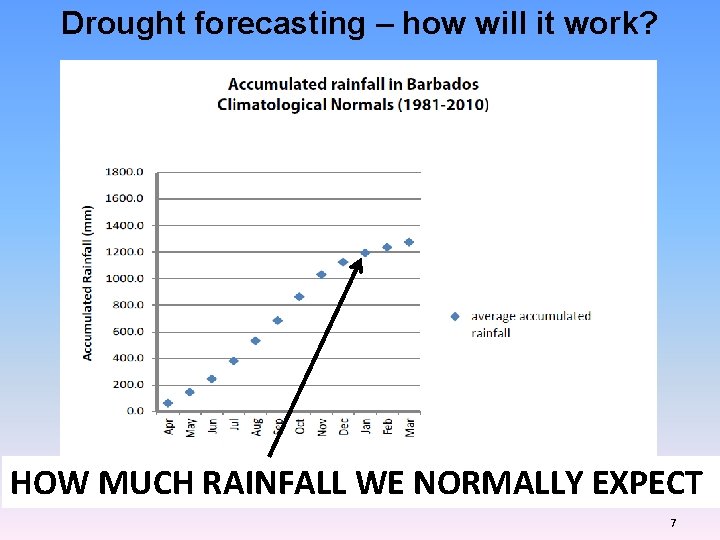
Drought forecasting – how will it work? HOW MUCH RAINFALL WE NORMALLY EXPECT 7
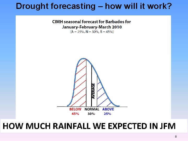
Drought forecasting – how will it work? HOW MUCH RAINFALL WE EXPECTED IN JFM 8
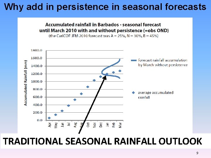
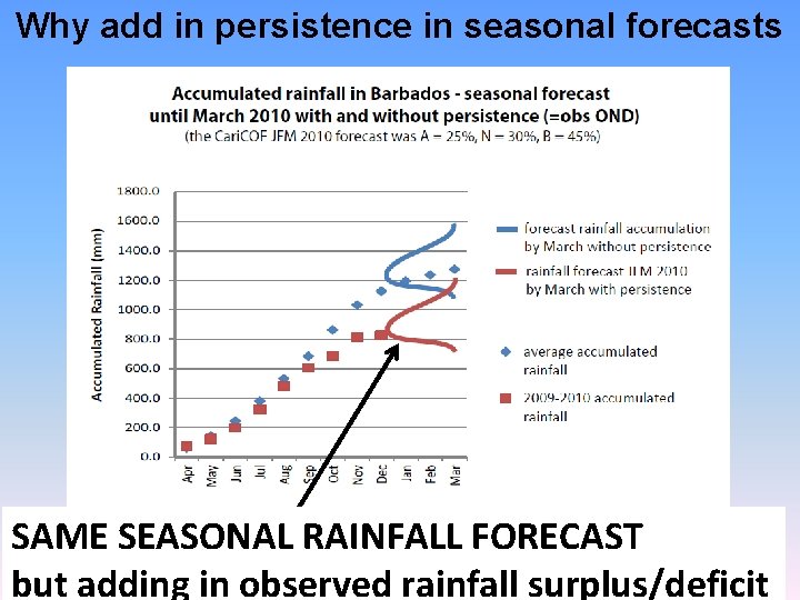
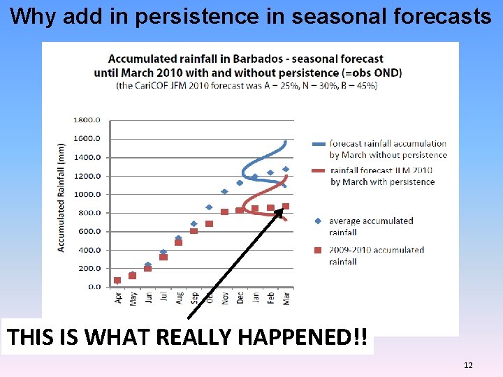
Why add in persistence in seasonal forecasts TRADITIONAL SEASONAL RAINFALL OUTLOOK 9
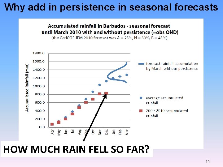
Why add in persistence in seasonal forecasts HOW MUCH RAIN FELL SO FAR? 10
Why add in persistence in seasonal forecasts SAME SEASONAL RAINFALL FORECAST but adding in observed rainfall surplus/deficit 11
Why add in persistence in seasonal forecasts THIS IS WHAT REALLY HAPPENED!! 12
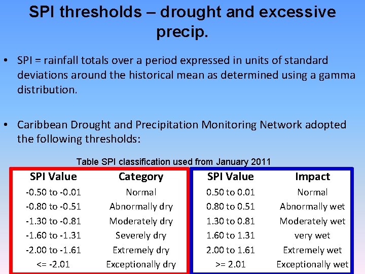
SPI thresholds – drought and excessive precip. • SPI = rainfall totals over a period expressed in units of standard deviations around the historical mean as determined using a gamma distribution. • Caribbean Drought and Precipitation Monitoring Network adopted the following thresholds: Table SPI classification used from January 2011 SPI Value Category SPI Value Impact -0. 50 to -0. 01 -0. 80 to -0. 51 -1. 30 to -0. 81 -1. 60 to -1. 31 -2. 00 to -1. 61 <= -2. 01 Normal Abnormally dry Moderately dry Severely dry Extremely dry Exceptionally dry 0. 50 to 0. 01 0. 80 to 0. 51 1. 30 to 0. 81 1. 60 to 1. 31 2. 00 to 1. 61 >= 2. 01 Normal Abnormally wet Moderately wet very wet Extremely wet Exceptionally wet 13
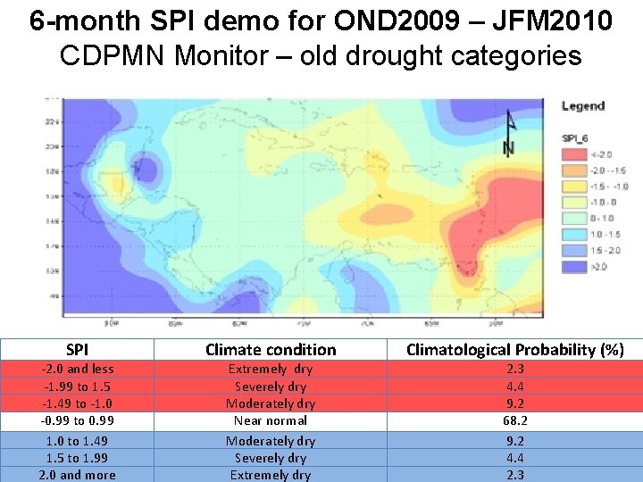
6 -month SPI demo for OND 2009 – JFM 2010 CDPMN Monitor – old drought categories SPI -2. 0 and less -1. 99 to 1. 5 -1. 49 to -1. 0 -0. 99 to 0. 99 1. 0 to 1. 49 1. 5 to 1. 99 2. 0 and more Climate condition Extremely dry Severely dry Moderately dry Near normal Moderately dry Severely dry Extremely dry Climatological Probability (%) 2. 3 4. 4 9. 2 68. 2 9. 2 4. 4 2. 3 14
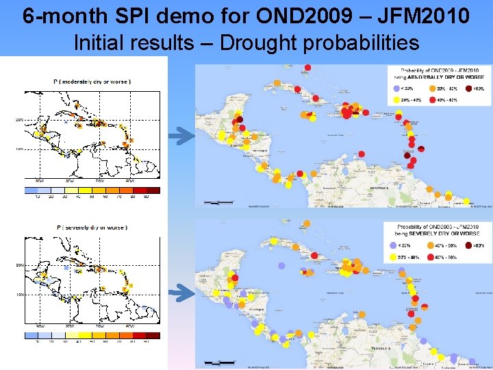
6 -month SPI demo for OND 2009 – JFM 2010 Initial results – Drought probabilities 15
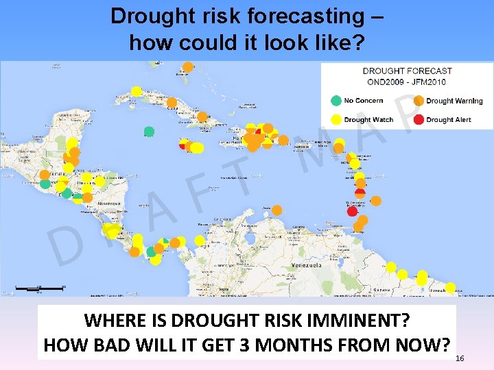
Drought risk forecasting – how could it look like? WHERE IS DROUGHT RISK IMMINENT? HOW BAD WILL IT GET 3 MONTHS FROM NOW? 16
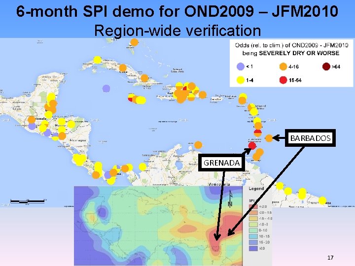
6 -month SPI demo for OND 2009 – JFM 2010 Region-wide verification BARBADOS GRENADA 17
DROUGHT OUTLOOK FOR THE END OF AUGUST 2014 6 -month SPI outlook 18
SPI outlook MAMJJA – what’s the probability for impactful drought? • In the wet season, sufficient rain falls over the territories to not cause drought impacts, even when rainfall is a bit lower than usual. • Only severely dry conditions (or worse) would cause significant impacts to our economic sectors, in particular agriculture and water resource management. • So we ask: 1. for the hurricane season 2014, what are the chances for impactful drought across the Caribbean? 2. Is there any area where drought risk is imminent? 3. Is there any concern beyond the wet/hurricane season? 19
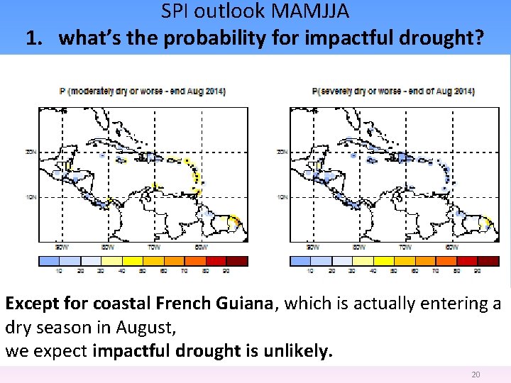
SPI outlook MAMJJA 1. what’s the probability for impactful drought? Except for coastal French Guiana, which is actually entering a dry season in August, we expect impactful drought is unlikely. 20
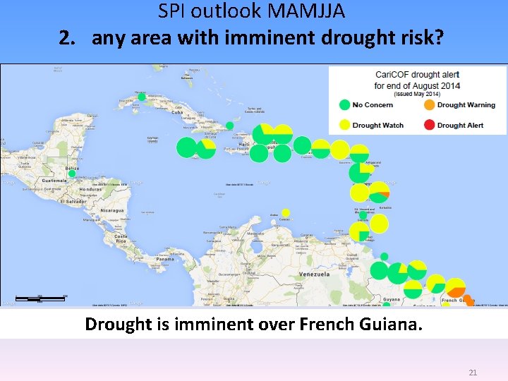
SPI outlook MAMJJA 2. any area with imminent drought risk? Drought is imminent over French Guiana. 21
SPI outlook MAMJJA 3. any concern beyond the wet/hurricane season? • El Niño is associated with a drier wet season. • If El Niño manifests, less water will be stored during the wet season. • By consequence, less water would be available for use in the dry season, which is our tourist season. CONSERVE WATER!! Especially in the Eastern and Southern Caribbean 22
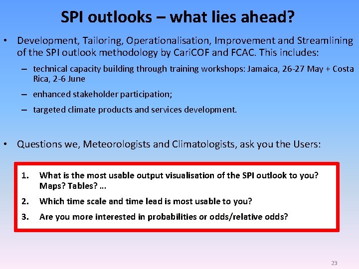
SPI outlooks – what lies ahead? • Development, Tailoring, Operationalisation, Improvement and Streamlining of the SPI outlook methodology by Cari. COF and FCAC. This includes: – technical capacity building through training workshops: Jamaica, 26 -27 May + Costa Rica, 2 -6 June – enhanced stakeholder participation; – targeted climate products and services development. • Questions we, Meteorologists and Climatologists, ask you the Users: 1. What is the most usable output visualisation of the SPI outlook to you? Maps? Tables? … 2. Which time scale and time lead is most usable to you? 3. Are you more interested in probabilities or odds/relative odds? 23
Thank you 24