Remote Sensing Microwave Remote Sensing 1 Passive Microwave


 ► Ranging - distance from the antenna to the")
 ► The \"all weather\" capability: - the l used")
 ► Spatial resolution - spatial scale at 1: 100,")


 Slant-range resolution (Sr) is consistent - equal to half the")

 ► is determined by the angular beam width b and")


- Slides: 32
Remote Sensing Microwave Remote Sensing
1. Passive Microwave Sensors Microwave emission is related to temperature and emissivity ► Microwave radiometers are sensitive to l = 0. 1 mm - 30 cm ► The interpretation requires knowledge of the system, the atmosphere, and thermal property of the objects ►
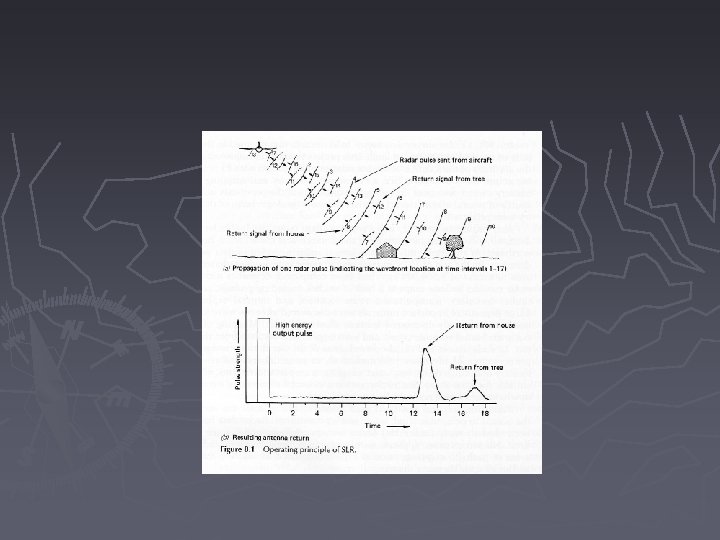
2. Active Microwave Sensors Radars RADAR: RAdio Detection And Ranging
2. Active Microwave Sensors Radars ► Transmitter: transmits repetitive pulse of microwave energy ► Receiver: receives the reflected signal through antenna and filters and amplifies the signal
2. Active Microwave Sensors Radars ► Antenna array: transmits a narrow beam of microwave energy ► Recorder: image records and displays the signal as an
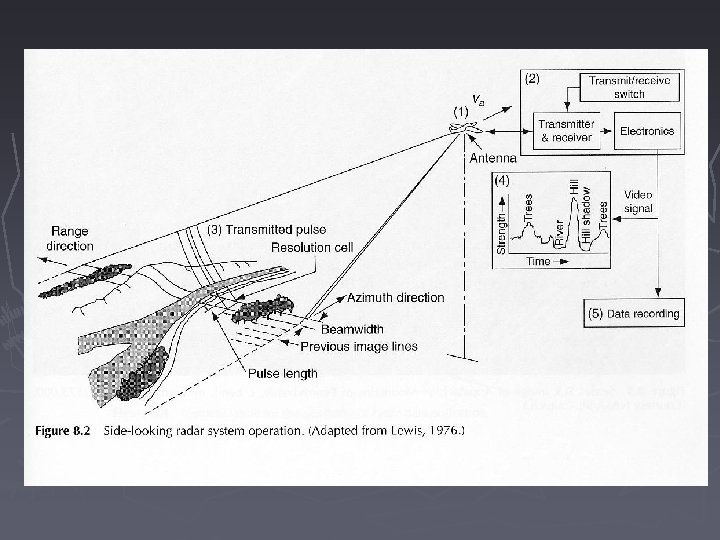
3. Side-Looking Airborne Radar (SLAR) ► Ranging - distance from the antenna to the features can be calculated by measuring the time delay between the time when a signal is transmitted to the time its echo is received ► Detecting frequency and polarization shifts - by comparing the transmitted signal of known properties to the received signal
3. Side-Looking Airborne Radar (SLAR) ► The "all weather" capability: - the l used by SLAR is long enough to penetrate clouds and light rain, e. g. applications in tropical area - SLAR systems are independent from solar illumination, which makes night missions possible
3. Side-Looking Airborne Radar (SLAR) ► Spatial resolution - spatial scale at 1: 100, 000, between Landsat and air photo - spectral information different from other sensor systems
4. Geometry of the Radar Image ► Radar shadow ► Radar layover ► Radar foreshortening
4. Geometry of the Radar Image ► Depression angle ► Far, mid, and near-range portion of a radar image ► Radar shadow, more severe in the far range
4. Geometry of the Radar Image
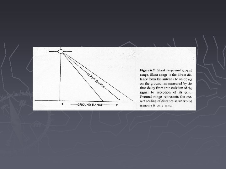
4. Geometry of the Radar Image ► Slant range distance - direct distance from the antenna to an object on the ground measured by time delay ► Ground range distance - distance of correct scaling as we would measure on a map
4. Geometry of the Radar Image ► Geometric errors - because radars collect information in slant range distance Radar layover ► Radar foreshortening ►
4. Geometry of the Radar Image ► Radar layover - the top of a tall object appears closer to the antenna than its base - the antenna receives the echo of the top before the base - it is more severe in the near range
Radar Layover
Radar Layover
4. Geometry of the Radar Image ► Radar foreshortening - with modest or high relief in the mid or far range portion - features maintain relative position but incorrect distance causing near range slope appear steeper and far range slope gentler
Radar Foreshortening
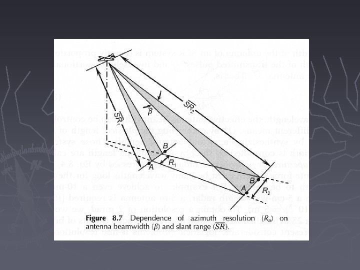
5. Resolutions Slant range resolution ► Ground range resolution ► Azimuthal resolution ►
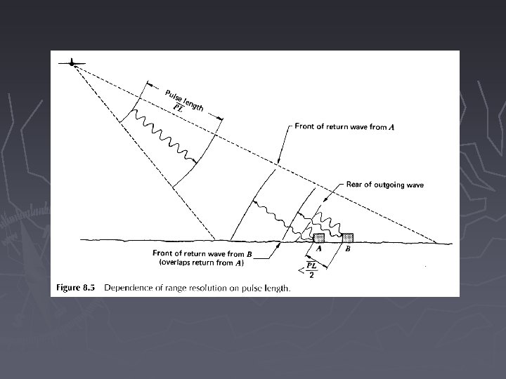
5. Resolutions ► Two determinant parameters: pulse length and antenna beam width - the pulse length dictates the spatial resolution in the direction of energy propagation - the width of the antenna beam determines the resolution cell size in the flight direction
Range Resolutions (along track) Slant-range resolution (Sr) is consistent - equal to half the transmitted pulse length PL/2 ► Ground-range resolution (Rr) changes with distance from the aircraft - inversely related to the cosine of depression angle Rr = slant range resolution/cosqd, qd - depression angle ►
Range Resolutions
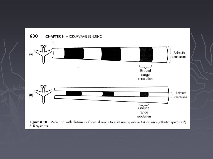
Azimuth Resolution (cross track) ► is determined by the angular beam width b and slant range Sr - while beam width b is inversely related to antenna length AL Ra = Sr ·b, b = l/AL, l-pulse wavelength - near range portion has finer resolution than the far range
Readings ► Chapter 8