MONTANA in PREHISTORY Environment Montana is a place


 grow mostly in the western")


- Slides: 64
MONTANA in PREHISTORY
Environment • Montana is a place of broad dimensions and sharp contrasts
“Treasure State” • 147, 138 square miles – Nation’s fourth largest state • 535 miles from east to west • 275 miles from north to south • Population of less than a million people – Country’s sixth least populated state • “acreage state”- lots of land few people
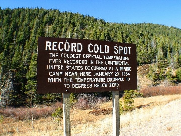
• Granite Peak- 12, 850 feet • Kootenai River- 1, 800 feet • Temperatures vary from the very hottest, occasionally over 110 degrees in the far eastern section , to a low of nearly 70 degrees below zero at Rogers Pass near Helena in 1954
Topography • Alpine peaks of Glacier National Park to rolling plains near the Dakota state line.
Geologic Past • Sixty million years ago • The mountains of western Montana were formed by massive shifts of the earth’s surface and the explosive spurting of lava through volcanoes and fissures.
Geologic Past • Ancient seas and lakes rose and fell, covering at various times all of today’s Montana, leaving behind fascinating geological formations and sedimentary deposits of limestone, phosphates, and many other compounds
Geologic Past • Great swamps formed east of the mountains and were later buried to become coal and oil fields.
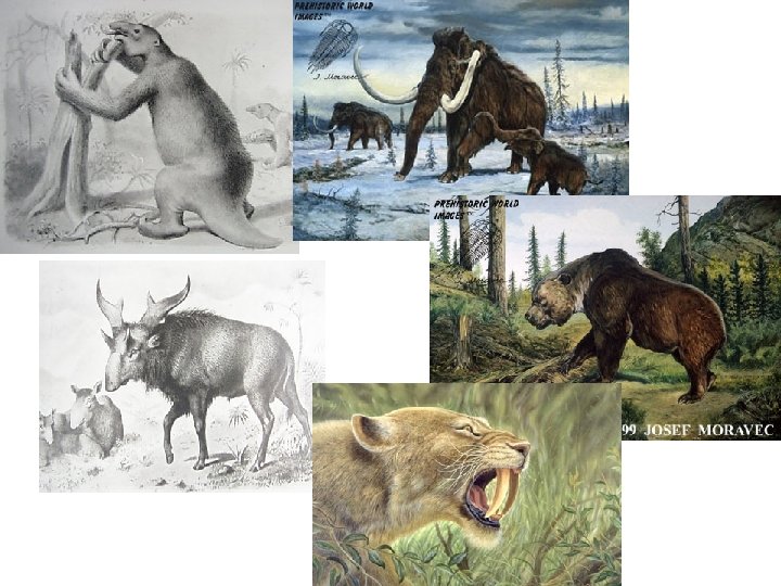
After the Seas Receded • Dinosaurs roamed the plains east of the Rockies.
Fossils found in Montana • Tyrannosaurus fossil – Found north of Jordan in 1908 – Judith Basin – Bears Paw Mountains – Rocky Mountain Front in the Two Medicine Formation • Duckbilled Maiasaura – Choteau
Dinosaurs died off sixty to eighty million years ago at the dawn of the age of mammals.
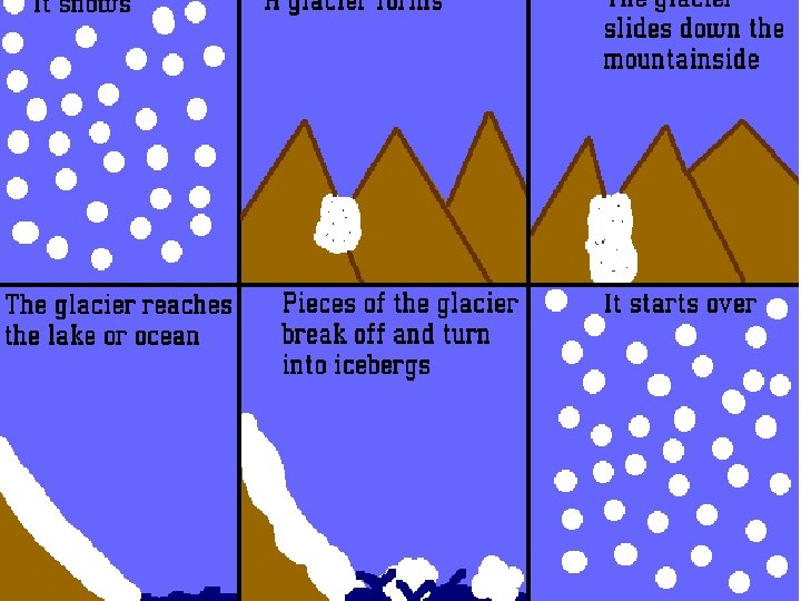
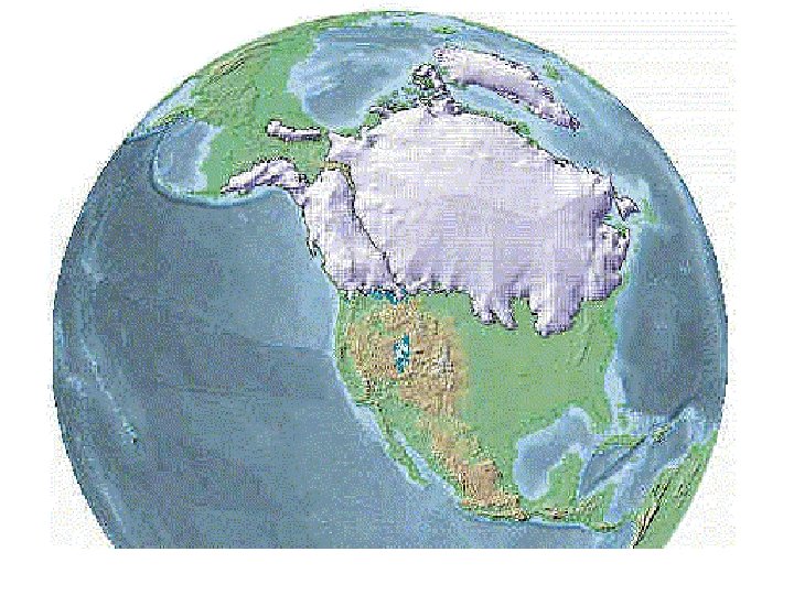
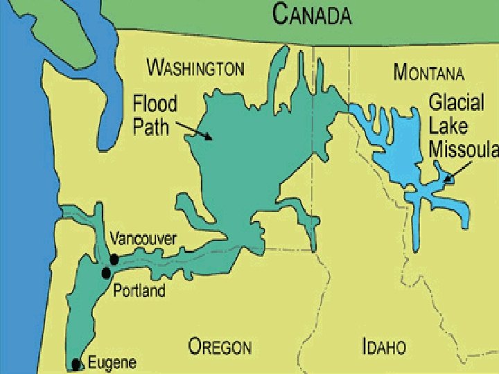
Pleistocene Era • Glacial Moving – Glaciers moved south from present day Canada into present day Montana. Four different times the glaciers moved south as far as Great Falls and Glendive. Each time the glaciers melted and receded • Forming U-shaped valleys and causing debris to dam huge lakes.
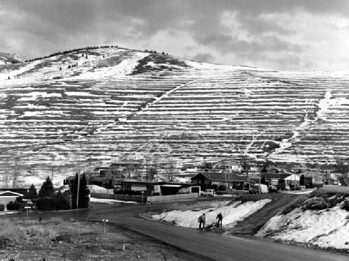
Lake Missoula • Flooded all of the valleys west of the Rockies to a depth of 800 feet or greater • Glaciers in the mountains hallowed out and formed wider valleys and more lakes
Changed Waterways • Missouri River – First flowed to the Arctic north of Hudson Bay. Ice sheets blocked and shifted it eastward and eventually southward to the Gulf of Mexico.
Western Montana • Western third of the state has the Rocky Mountains
Eastern Montana • Eastern two thirds of the state are plains
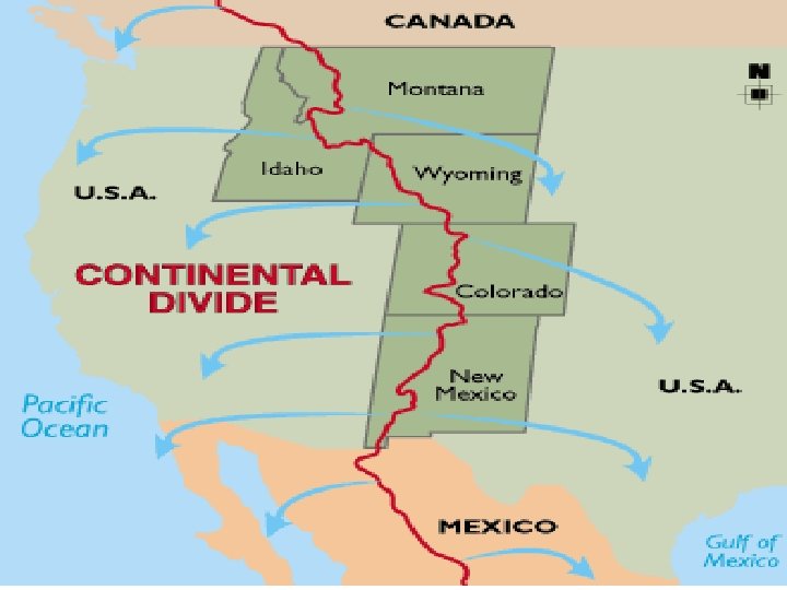
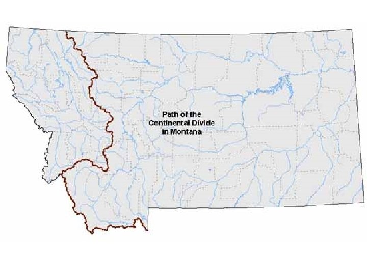
Continental Divide • Follows the primary mountain chains southward from Glacier National Park to Butte, where it bows westward to the Bitterroot crest like an inverted question mark, then turns south eastward again into Yellowstone Park, enclosing the Beaverhead Basin of southwestern Montana in the Atlantic drainage.
A continental divide is a line of elevated terrain which forms a border between two watersheds such that water falling on one side of the line eventually travels to one ocean or body of water, and water on the other side travels to another, generally on the opposite side of the continent. Because the exact border between bodies of water is usually not clearly defined, the continental divide is not always definite for any continent (The International Hydrographic Organization's publication Limits of Oceans and Seas defines exact boundaries of oceans, but it is not universally recognized). Moreover, some rivers empty into inland seas, and thus do not end up in the oceans.
• East side of Continental Divide- waters flow east into the Missouri River , which flows into the Mississippi and finally into the Gulf of Mexico. • West side of Continental Divide- waters flow west into the Columbia River Basin and finally out into the Pacific Ocean.
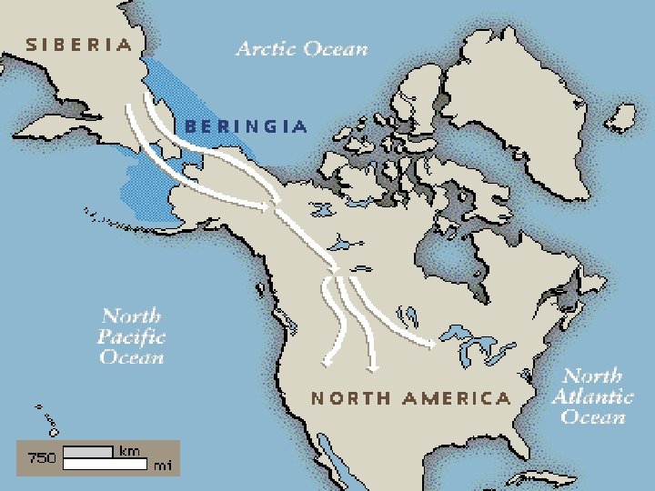
Early Immigrants • 15 to 20 thousand years ago • Bering land bridge • Following Pleistocene animals
The Three Ecological Regions of Montana • Driving across Montana is like passing through three different countries. Within its boundaries lie three distinctly different ecologies: – The western region (Columbia Plateau) – The central region (Rocky Mountain Front) – The eastern region (Northern Plains • Geography, climate, and resources have shaped the history and culture of each region differently.
The Western Region: Rugged Mountains, Forested Ridges, High Precipitation • Western Montana is crumpled into continuous mountains, winding rivers, and thick forests. • Natural Mountain Passes • Wide Fertile Valleys • Precipitation (rain and snow) – Rain-average of 15 to 25 inches per year – Snow-some areas more than 300 inches per year » Greener region and supports more vegetation than any other region in the state.
What to look for: • Montana’s western rivers feed the Columbia River, which flows west to the Pacific Ocean.
• Flathead Lake, encompasses 197 square miles of northwestern Montana, and is the larges natural freshwater body of water west of the Great Lakes
• Ash, elm, cedar, and larch trees grow only in the western region. Montana Cedar Montana Elm Western Larch
• The tallest pine tree in Montana is a 300 -year -old ponderosa pine over 180 feet tall, growing near St. Regis
• A grove of giant cedar trees, unlike any other trees in the state, grows near Libby • Most of Montana’s grizzly bears live in western Montana.
• Bear grass and bitterroot (the state flower) grow mostly in the western region.
Central Region: Isolate Mountains, High Plains, Chinook Winds • Central Montana spreads east from the foothills of the Rocky Mountains. Its small scattered mountain ranges rise above gently rolling plains. • Prominent mountain clusters – Sweetgrass Hills, the Bear’s Paws, the Little Rockies, the Highwoods, the Moccasin-Judiths, the Big Snowys, the Crazys, the Pryors, the Big and Little Belts and the Bighorns.
What to look for • Ponderosa pine, Douglas fir and spruce trees cover the mountains, while blue bunch wheatgrass, timothy grass and fescue fill the grasslands
• Lupines, larkspur and Indian blanket flower grow on the hillsides, and prickly pear cactus and sagebrush grow in the lowlands
• Montana’s two largest river systems, the Missouri River and the Yellowstone River, begin in central Montana.
• Mule deer and pronghorn spread throughout the lowlands, with black bear, elk and moose in the forests and hills.
• Pheasants, sage grouse and Hungarian partridge hide in the brush, and hawks, falcons, and eagles soar in the sky.
• Trout, sturgeon and bass are the most important fish species
Eastern Region: Rolling plains, persistent winds, the endless sky • Almost uninterrupted grassland. • The Missouri Breaks and the badlands in Makoshika State Park form two of the most dramatic examples of a landscape sculpted by water and wind erosion. – Eastern Montana is dry, windy, and extreme
Irrigation-Bringing in a supply of water to make farmland more productive • Ranches and farms require more irrigation, more space for grazing, and a little more patience than in the other regions.
What to look for: • The Fort Peck Dam forms the Fort Peck Reservoir on the Missouri River • The fifth largest human make reservoir in the US. • 134 miles long, 220 feet at its deepest and 1, 520 miles of shoreline.
• Woody shrubs like juniper thrive in the dry, elevated soils of eastern Montana, while ponderosa pine, Douglas fir and spruce trees grow in the high elevations.
Symbols of the Treasure State • Symbols help us express feelings like respect for the land, pride in our communities, and a sense of place.
State Seal • A sunrise shines over snowy mountains • Pick, shovel, plowsymbols of Montana’s mining and farming heritage • Mountains, hills, trees, cliffs, waterfalls, and the Missouri River
State Flag • Shows the state seal on a blue rectangle with yellow edges. • “MONTANA” was added to the top of the flag in 1981
State Song • Three official state songs – “Montana” -1910 – “Montana Melody”-1983 – “Montana Lullaby”-2007
State Gemstones: Agate and Sapphire • Agates from the east • Sapphires from the west
State Flower: Bitterroot • Montana Indians used the dried roots of the bitterroot for food and trade
State Tree: Ponderosa Pine • The most common pine tree in Montana. • Can grow up to 300 ft tall and 8 ft thick
State Animal: Grizzly Bear • Most of the grizzly bears in the Lower 48 states live in Montana • Adult grizzlies can grow to 8 ft long and weigh 1, 500 pounds
State Fossil: Maiasaura • Montana adopted the Maiasaura as its state fossil after an important discovery at Egg Mountain, near Choteau. • They took care of their babies the way birds do
State Fish: Blackspotted Cutthroat Trout • Adopted this fish to help save it from its decline due to overfishing and changes in the environment. • Name comes from the black spots that run down its back
State bird: Western Meadowlark • Known for its loud, cheerful song • As big as a robin, with a bright yellow chest and throat under a black collar
State Butterfly: The Mourning Cloak • Bright blue shimmering spots along the inner edge of a yellow or beige border characterize the mourning cloak’s dark brown wings
State grass: Bluebunch Wheatgrass • Found all over the state • Good grazing for cattle and sheep
State Nickname: “The Treasure State” and “Big Sky Country” • Treasure State- state’s valuable minerals, gems and precious metals • 1960 Montana also adopted the “Big Sky Country” after a novel called The Big Sky by Montana author A. B. Guthrie Jr.