MATA KULIAH DINAMIKA IKLIM TROPIS KOMPETENSI Mahasiswa Mampu


- Slides: 24

MATA KULIAH DINAMIKA IKLIM TROPIS KOMPETENSI : Mahasiswa Mampu Memahami, Menganalisis dan Menginterpretasi Fenomena Dinamika Cuaca-Musim-Iklim yang Terjadi di Wilayah Beriklim Tropis.

MATERI KULIAH Minggu 1 : Batasan Wilayah dan Karakteristik Iklim Tropis Minggu 2 : Faktor Pengendali Cuaca / Iklim Tropis Minggu 3 : Sirkulasi Global, Regional dan Lokal Minggu 4 : Variasi Komponen Iklim Tropis 1 Minggu 5 : Variasi Komponen Iklim Tropis 2 Minggu 6 : Variasi Komponen Iklim Tropis 3 Minggu 7 : Dinamika Sistem Monsoon Minggu 8 : Dinamika ENSO (El Nino dan La Nina) Minggu 9 : Dinamika Dipole Mode (Indian Ocean Dipole) Minggu 10 : Review Makalah Minggu 11 : Dinamika Siklon Tropis Minggu 12 : Dinamika Kekeringan di Wilayah Iklim Tropis Minggu 13 : Cuaca Ekstrim di Wilayah Tropis Kontinental Minggu 14 : Cuaca Ekstrim di Wilayah Tropis Maritim/Kepulauan Minggu 15 : Resume Bulletin Minggu 16 : Ujian Akhir Semester 2

DAFTAR PUSTAKA • Laing, A & J. L. Evans (2011). Introductions to Tropical Meteorology, The COMET Program, 2 nd Editions, • T. N. Krishnamurti, T. N. , L. Stefanova, & V. Misra (2013). Tropical Meteorology : An Introduction, Springer, New York. • Reding, A. J. , R. D. Thompson & A. C. Millington (1995). Humid Tropical Environments, Blackwell, Massachusetts. • Barry, R. G. & R. J. Chorley (1998). Atmosphere, Weather and Climate, Routledge, London • WMO Publications (Bulletins, Manual and Statements). • Journal : Climate Dynamics, Atmospheric Research, dan Dynamics of Atmosphere and Oceans. 3

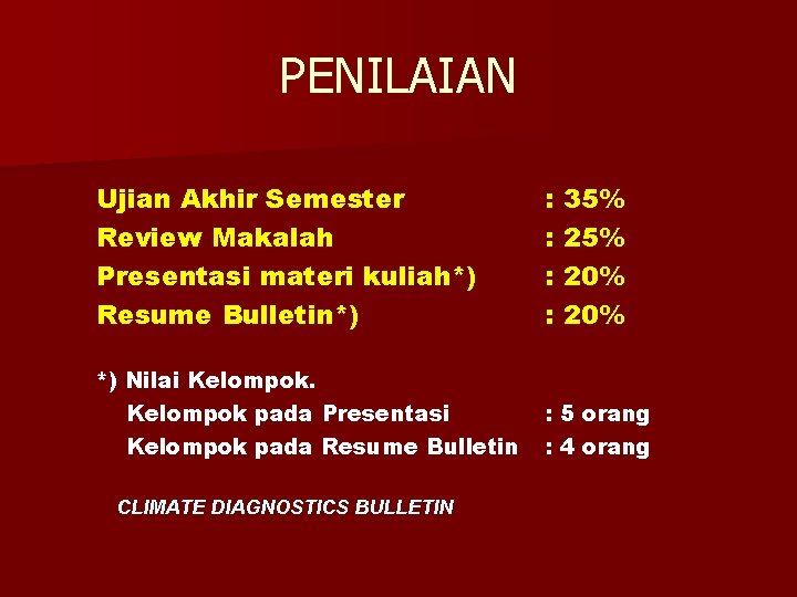
PENILAIAN Ujian Akhir Semester Review Makalah Presentasi materi kuliah*) Resume Bulletin*) : : *) Nilai Kelompok pada Presentasi Kelompok pada Resume Bulletin : 5 orang : 4 orang CLIMATE DIAGNOSTICS BULLETIN 35% 20% 20%

MINGGU 1 INTRODUKSI DINAMIKA IKLIM TROPIS Ø Batasan Wilayah Tropis Ø Karakteristik Iklim Tropis 5

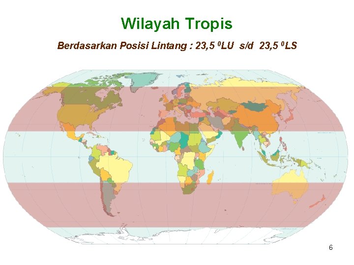
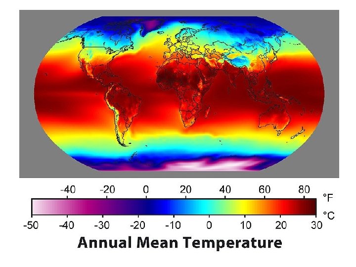
Wilayah Tropis Berdasarkan Posisi Lintang : 23, 5 0 LU s/d 23, 5 0 LS 6

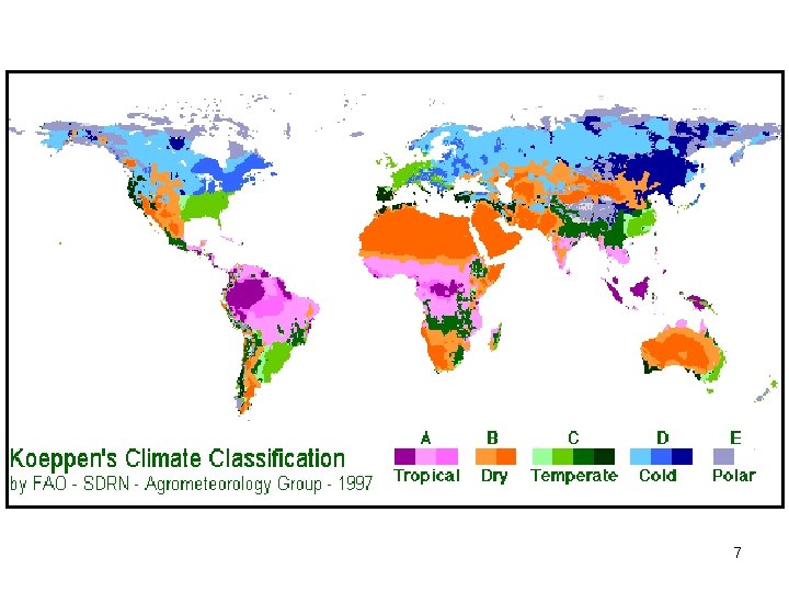
7

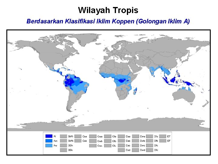
Wilayah Tropis Berdasarkan Klasifikasi Iklim Koppen (Golongan Iklim A) 8

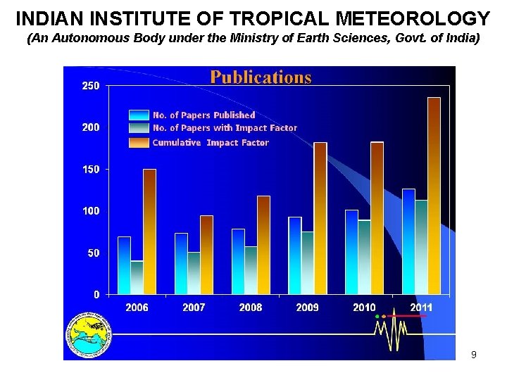
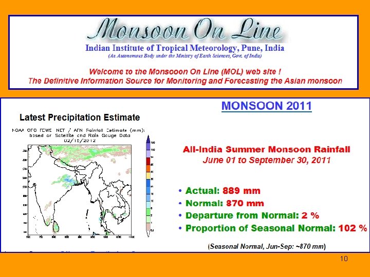
INDIAN INSTITUTE OF TROPICAL METEOROLOGY (An Autonomous Body under the Ministry of Earth Sciences, Govt. of India) 9

10

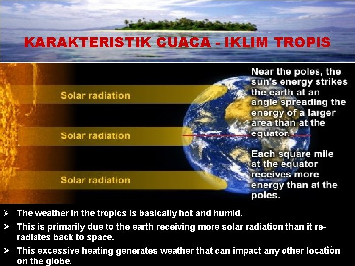
KARAKTERISTIK CUACA - IKLIM TROPIS Ø The weather in the tropics is basically hot and humid. Ø This is primarily due to the earth receiving more solar radiation than it reradiates back to space. 11 Ø This excessive heating generates weather that can impact any other location on the globe.

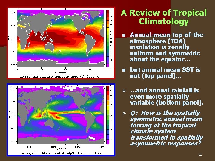
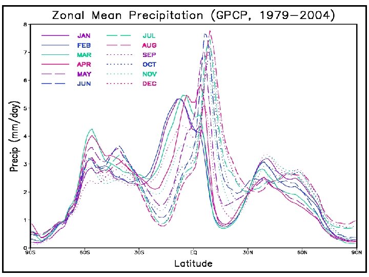
A Review of Tropical Climatology n Annual-mean top-of-theatmosphere (TOA) insolation is zonally uniform and symmetric about the equator… n but annual mean SST is not (top panel)… Ø …and annual rainfall is even more spatially variable (bottom panel). Ø Q: How is the spatially symmetric annual mean forcing of the tropical climate system transformed to spatially asymmetric responses? 12

13

14

There is abundant rainfall due to the rising air created by the sun's heating, and during certain periods, thunderstorms can occur every day. Nevertheless, the tropics still receive a considerable amount of sunshine, and when combined with the excessive rainfall, provide ideal growing conditions. Because a substantial part of the Sun's heat energy is used up in evaporation and rain formation, temperatures in the tropics rarely exceed 95°F (35°C). At night the abundant cloud cover restricts heat loss, and minimum temperatures fall no lower than about 72°F (22°C). This high level of temperature is maintained with little variation throughout the year. Therefore, the seasons are not distinguished by warm and cold periods but by variation of rainfall and cloudiness. 15

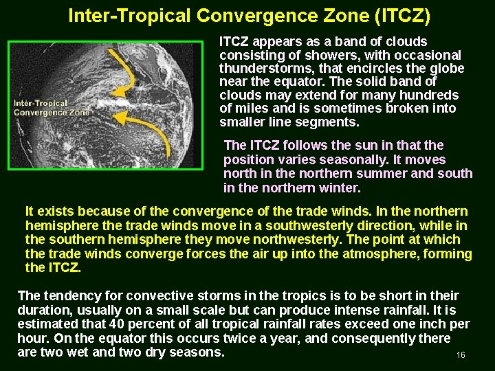
Inter-Tropical Convergence Zone (ITCZ) ITCZ appears as a band of clouds consisting of showers, with occasional thunderstorms, that encircles the globe near the equator. The solid band of clouds may extend for many hundreds of miles and is sometimes broken into smaller line segments. The ITCZ follows the sun in that the position varies seasonally. It moves north in the northern summer and south in the northern winter. It exists because of the convergence of the trade winds. In the northern hemisphere the trade winds move in a southwesterly direction, while in the southern hemisphere they move northwesterly. The point at which the trade winds converge forces the air up into the atmosphere, forming the ITCZ. The tendency for convective storms in the tropics is to be short in their duration, usually on a small scale but can produce intense rainfall. It is estimated that 40 percent of all tropical rainfall rates exceed one inch per hour. On the equator this occurs twice a year, and consequently there are two wet and two dry seasons. 16

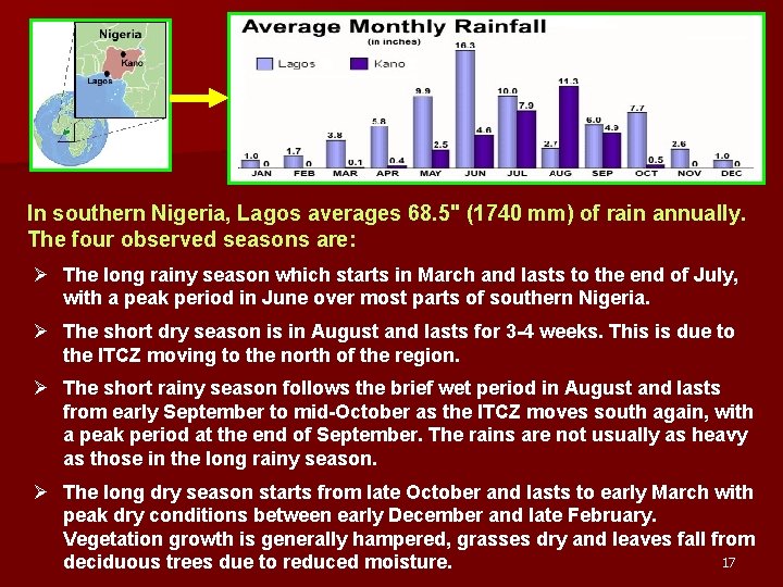
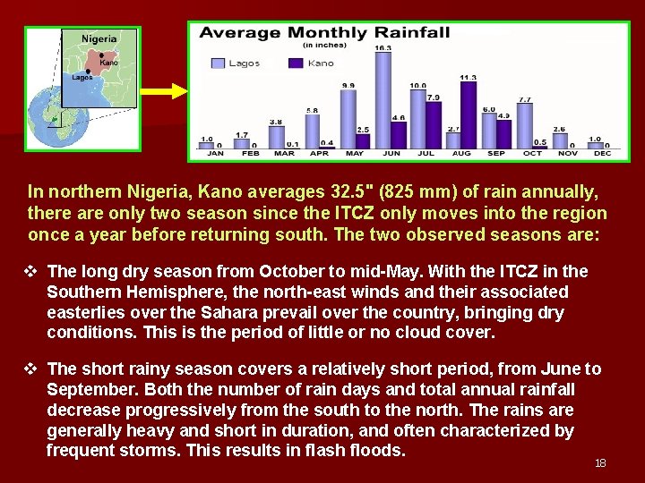
In southern Nigeria, Lagos averages 68. 5" (1740 mm) of rain annually. The four observed seasons are: Ø The long rainy season which starts in March and lasts to the end of July, with a peak period in June over most parts of southern Nigeria. Ø The short dry season is in August and lasts for 3 -4 weeks. This is due to the ITCZ moving to the north of the region. Ø The short rainy season follows the brief wet period in August and lasts from early September to mid-October as the ITCZ moves south again, with a peak period at the end of September. The rains are not usually as heavy as those in the long rainy season. Ø The long dry season starts from late October and lasts to early March with peak dry conditions between early December and late February. Vegetation growth is generally hampered, grasses dry and leaves fall from 17 deciduous trees due to reduced moisture.

In northern Nigeria, Kano averages 32. 5" (825 mm) of rain annually, there are only two season since the ITCZ only moves into the region once a year before returning south. The two observed seasons are: v The long dry season from October to mid-May. With the ITCZ in the Southern Hemisphere, the north-east winds and their associated easterlies over the Sahara prevail over the country, bringing dry conditions. This is the period of little or no cloud cover. v The short rainy season covers a relatively short period, from June to September. Both the number of rain days and total annual rainfall decrease progressively from the south to the north. The rains are generally heavy and short in duration, and often characterized by frequent storms. This results in flash floods. 18

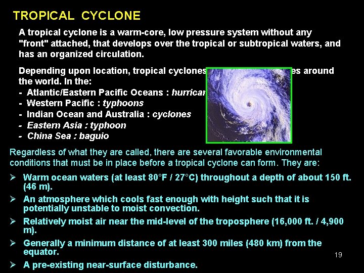
TROPICAL CYCLONE A tropical cyclone is a warm-core, low pressure system without any "front" attached, that develops over the tropical or subtropical waters, and has an organized circulation. Depending upon location, tropical cyclones have different names around the world. In the: - Atlantic/Eastern Pacific Oceans : hurricanes - Western Pacific : typhoons - Indian Ocean and Australia : cyclones - Eastern Asia : typhoon - China Sea : baguio Regardless of what they are called, there are several favorable environmental conditions that must be in place before a tropical cyclone can form. They are: Ø Warm ocean waters (at least 80°F / 27°C) throughout a depth of about 150 ft. (46 m). Ø An atmosphere which cools fast enough with height such that it is potentially unstable to moist convection. Ø Relatively moist air near the mid-level of the troposphere (16, 000 ft. / 4, 900 m). Ø Generally a minimum distance of at least 300 miles (480 km) from the equator. 19 Ø A pre-existing near-surface disturbance.

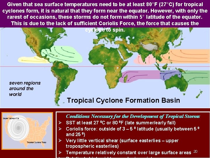
Given that sea surface temperatures need to be at least 80°F (27°C) for tropical cyclones form, it is natural that they form near the equator. However, with only the rarest of occasions, these storms do not form within 5° latitude of the equator. This is due to the lack of sufficient Coriolis Force, the force that causes the cyclone to spin. seven regions around the world Tropical Cyclone Formation Basin Conditions Necessary for the Development of Tropical Storms Ø SST at least 27 0 C or 80 0 F (late summer/early fall) Ø Coriolis force: outside of 3 – 5 0 latitude (usually between 5 0 and 25 0) Ø Very little vertical shear (surface easterlies – upper tropospheric easterlies) Ø Temperature relatively constant over large surface areas 20

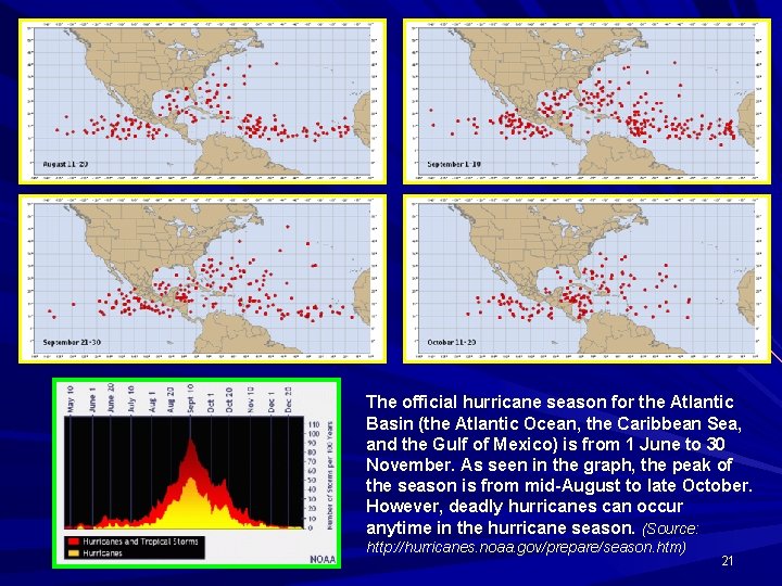
The official hurricane season for the Atlantic Basin (the Atlantic Ocean, the Caribbean Sea, and the Gulf of Mexico) is from 1 June to 30 November. As seen in the graph, the peak of the season is from mid-August to late October. However, deadly hurricanes can occur anytime in the hurricane season. (Source: http: //hurricanes. noaa. gov/prepare/season. htm) 21

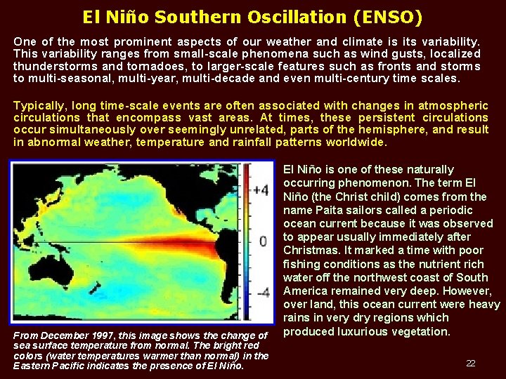
El Niño Southern Oscillation (ENSO) One of the most prominent aspects of our weather and climate is its variability. This variability ranges from small-scale phenomena such as wind gusts, localized thunderstorms and tornadoes, to larger-scale features such as fronts and storms to multi-seasonal, multi-year, multi-decade and even multi-century time scales. Typically, long time-scale events are often associated with changes in atmospheric circulations that encompass vast areas. At times, these persistent circulations occur simultaneously over seemingly unrelated, parts of the hemisphere, and result in abnormal weather, temperature and rainfall patterns worldwide. From December 1997, this image shows the change of sea surface temperature from normal. The bright red colors (water temperatures warmer than normal) in the Eastern Pacific indicates the presence of El Niño is one of these naturally occurring phenomenon. The term El Niño (the Christ child) comes from the name Paita sailors called a periodic ocean current because it was observed to appear usually immediately after Christmas. It marked a time with poor fishing conditions as the nutrient rich water off the northwest coast of South America remained very deep. However, over land, this ocean current were heavy rains in very dry regions which produced luxurious vegetation. 22

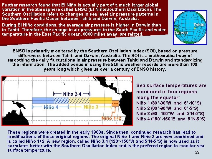
Further research found that El Niño is actually part of a much larger global variation in the atmosphere called ENSO (El Niño/Southern Oscillation). The Southern Oscillation refers to changes in sea level air pressure patterns in the Southern Pacific Ocean between Tahiti and Darwin, Australia. During El Niño conditions, the average air pressure is higher in Darwin than in Tahiti. Therefore, the change in air pressures in the South Pacific and water temperature in the East Pacific ocean, 8000 miles away, are related. ENSO is primarily monitored by the Southern Oscillation Index (SOI), based on pressure differences between Tahiti and Darwin, Australia. The SOI is a mathematical way of smoothing the daily fluctuations in air pressure between Tahiti and Darwin and standardizing the information. The added bonus in using the SOI is weather records are more than 100 years long which gives us over a century of ENSO history. Sea surface temperatures are monitored in four regions along the equator: Niño 1 (80°-90°W and 5°-10°S) Niño 2 (80°-90°W and 0°-5°S) Niño 3 (90°-150°W and 5°N-5°S) Niño 4 (150°-160°E and 5°N-5°S) These regions were created in the early 1980 s. Since then, continued research has lead to modifications of these original regions. The original Niño 1 and Niño 2 are now combined and is called Niño 1+2. A new region, called Niño 3. 4 (120°-150°W and 5°N-5°S) is now used as it corrolates better with the Southern Oscillation Index and is the prefered region to monitor sea surface temperature. 23

TERIMA KASIH