Lesson Understanding Land Measurement and Legal Descriptions Interest


- Slides: 53
Lesson Understanding Land Measurement and Legal Descriptions
Interest Approach • Ask students to write out the directions to their house on a piece of paper. • When finished ask them to give their paper to someone in the class that does not know where they live.
Interest Approach • Ask the other student if they think they would be able to find this house by following these directions. • Discuss with the class why clear and understandable instructions are needed to give the legal description of a property.
Student Learning Objectives 1. Explain the purpose of land measurement and legal descriptions. 2. Identify the systems of land measurement and legal description used in the United States. 3. Discuss the causes of irregular townships and sections.
Terms • • • Artificial monuments Base lines Clear title Meridian Natural monuments Regular township Section
Objective One Explain the purpose of land measurement and legal descriptions.
What is the Purpose of Land Measurement and Legal Descriptions? I. Land is owned as private property in the United States and is transferred in various ways from one owner to another.
What is the Purpose of Land Measurement and Legal Descriptions? To make this type of transfer possible, it is essential to have a system through which a purchaser can obtain a clear title to any tract of land. Clear Title: means that there are no legal claims against the ownership of the property.
What is the Purpose of Land Measurement and Legal Descriptions? • In order to transfer the real estate, its location must be positively and specifically described. • If this is not done, endless arguments and lawsuits may occur.
What is the Purpose of Land Measurement and Legal Descriptions? • Surveying land for the purpose of describing and locating it includes the work of identifying boundaries and recording descriptive data.
What is the Purpose of Land Measurement and Legal Descriptions? Although different systems of surveys can be used, they all accomplish these two objectives:
What is the Purpose of Land Measurement and Legal Descriptions? A. A land description gives the definite location of a specific tract of land. – Such a description can fit no other tract. – From it you can locate that specific area. – The legal description of property is given on many documents and papers, such as abstracts, deeds, and tax statements.
What is the Purpose of Land Measurement and Legal Descriptions? B. A land title, or title to a tract of land, is evidence of ownership. – Title to real estate is dependent on a legal description of the property, which in turn must be based on an official survey.
Objective Two Identify the systems of land measurement and legal description used in the United States.
What are the systems of land measurement and legal description? II. There are two systems of describing land used in the United States. One is known as the system of metes and bounds and the other is the system of rectangular surveys.
What are the systems of land measurement and legal description? A. Metes and bounds: The metes and bounds system of describing land is widely used in many parts of the world and was the system initially used in the United States.
What are the systems of land measurement and legal description? • In the eastern part of the United States, an area extending from the northern boundary of Florida to Canada and to the western boundaries of Georgia, Tennessee, Kentucky, West Virginia, Pennsylvania, New York, and parts of Ohio, were described under this system.
What are the systems of land measurement and legal description? • Texas, when admitted to the United States in 1845, had been previously a part of Mexico and has been described under a metes and bounds system.
What are the systems of land measurement and legal description? Since it is impossible to impose one system for land description on top of another, the old system has been retained.
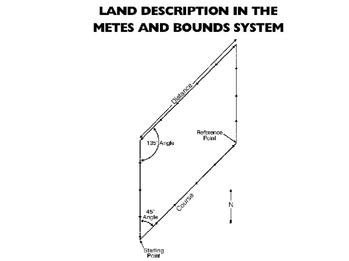
What are the systems of land measurement and legal description? There are three basic items that can be included in a land description in the metes and bounds system. They are: - Starting point - Courses and Distances - Irregular boundaries - Rectangular land surveys
What are the systems of land measurement and legal description? • Starting point: A description according to the metes and bounds system must have a starting place or point of reference. The description continues for specified distances along lines called courses until the tract has been circumscribed and the starting point is again reached.
What are the systems of land measurement and legal description? • These points may be trees, stones, rivers, or lakes and are called Natural Monuments. • Natural monuments and Artificial Monuments, such as government markers, fences, or highways, have the disadvantage that they may be moved or destroyed.
What are the systems of land measurement and legal description? • Courses and Distances: Courses are identified by direction, with distances being linear measurements along these lines.
What are the systems of land measurement and legal description? Sometimes a course has been partly described as connecting two natural monuments, such as trees, but generally it is described in terms of its angle to a point of reference. The usual point of reference is a Meridian or true north and south line.
What are the systems of land measurement and legal description? • Irregular Boundaries: Some tracts of land, such as those bordering lakes or rivers, have irregular boundaries.
What are the systems of land measurement and legal description? A tract described as lying along a river is typically interpreted as having one boundary at the middle line between the shores of the stream.
What are the systems of land measurement and legal description? Lake boundaries are somewhat different. The owners of land adjoining a natural lake own to the center, if the lake is not navigable; otherwise the title to the bed of the lake is in trust for the people.
What are the systems of land measurement and legal description? The ownership of artificial lake beds depends upon the words of conveyance used in transferring the shoreline property. Streets and highways can sometimes also serve as boundaries.
What are the systems of land measurement and legal description? • Rectangular Land Surveys: In 1785 the Continental Congress of the United States passed an ordinance directing that a rectangular system be used in surveying public lands.
What are the systems of land measurement and legal description? Thomas Jefferson was directed to organize it. The United States was the first country to use such a system, but Canada later adopted it.
What are the systems of land measurement and legal description? The rectangular survey system was set up to accomplish two things: 1. Provide for definite location of the land by establishing corner markers on the ground, 2. Provide a short, complete, direct, and easily understood legal description. The system involves the use of principal meridians, base lines, townships, sections, and tracts.
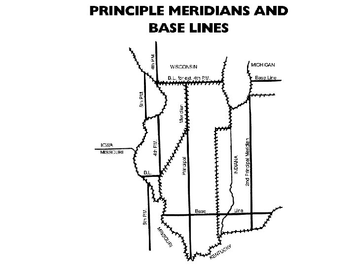
What are the systems of land measurement and legal description? B. Principal Meridians and Base Lines: These lines form the skeleton of the rectangular survey system.
What are the systems of land measurement and legal description? The intersection of the base line and the principal meridian is the starting point of the survey for a given area. The meridians are north and south lines. The Baselines are east and west lines.
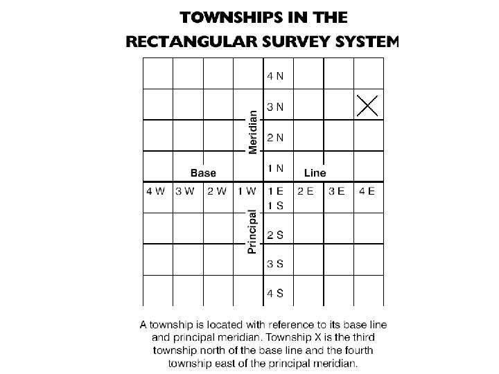
What are the systems of land measurement and legal description? 1. Townships and Sections: The location of a township can be expressed in terms of ranges east or west of the principal meridian and in terms of tiers of townships north or south of the base line.
What are the systems of land measurement and legal description? • A Regular Township is six miles square. – A section is located within a township. • Each square mile of a township is considered a Section.
What are the systems of land measurement and legal description? • In all surveys since 1796, the sections in each township have been numbered from 1 to 36, beginning at the upper right, or northeast, corner of the township.
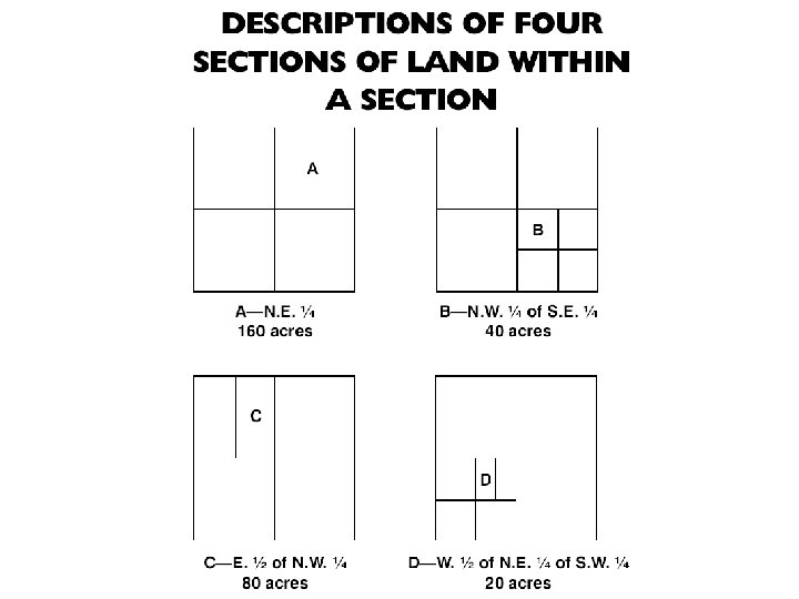
What are the systems of land measurement and legal description? 2. Tracts of Land: A tract of land is located within a section. • If the tract in question is smaller than a section or is located in more than one section, the fraction or fractions of the section or sections must be indicated.
What are the systems of land measurement and legal description? This is done by identifying and locating the fractional portion of each section for each tract of land. In land descriptions the last fraction given is the largest area or portion of the section.
What are the systems of land measurement and legal description? We read from left to right. However, in writing a description from a map or in locating a tract of land on a map, we proceed from right to left.
Objective Three Discuss the causes of irregular townships and sections.
What Causes Irregular Townships and Sections? III. It can be observed that not all townships and sections in a rectangular survey are square. There are several possible reasons for this. - Curvature of the Earth - Human error - Surveys meeting
What Causes Irregular Townships and Sections? • Curvature of the Earth: Applying a rectangular system to a curved surface, such as the Earth, results in some irregularities. – Meridian lines get closer together as they approach the north and south poles.
What Causes Irregular Townships and Sections? Therefore, a township based off these lines cannot be a perfect square. It is impossible for all sections to be perfectly square and to contain exactly 640 acres. Sections containing more or less than 640 acres may be found in the north and west rows of sections in a township.
What Causes Irregular Townships and Sections? Most of the other sections will be approximately 640 acres in size. When designing this system, surveyors were requested to throw all deficiencies or excesses in acreage into the north and west sides of the townships.
What Causes Irregular Townships and Sections? • Human Error: The surveyors who conducted these surveys are human and therefore made mistakes. Occasionally errors in surveying have resulted in townships with sections of odd shapes and sizes.
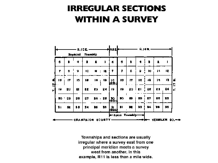
What Causes Irregular Townships and Sections? • Surveys Meeting: Where the survey from one principal meridian meets the survey from another, both irregular townships and sections are sure to occur. • The same is true where surveys from two different base lines meet.
Review / Summary • • Land is owned as private property in the United States and is transferred in various ways from one owner to another. A land description gives the definite location of a specific tract of land. There are two systems of describing land used in the United States. A Regular Township is six miles square.
Review / Summary It can be observed that not all townships and sections in a rectangular survey are square. There are several possible reasons for this. - Curvature of the Earth - Human error - Surveys meeting Applying a rectangular system to a curved surface, such as the Earth, results in some irregularities.